close
-
Layers w
- Weather Layers
- Pro
- Pro
- Pro
- Pro
- Pro
- Pro
- More Layers
- Pro
- Pro
- Pro
- Pro
-
Upgrade to

3D
Trail Conditions
- Unknown
- Snow Groomed
- Snow Packed
- Snow Covered
- Snow Cover Partial
- Freeze/thaw Cycle
- Icy
- Prevalent Mud
- Wet
- Variable
- Ideal
- Dry
- Very Dry
Trail Flow (Ridden Direction)
Trailforks scans users ridelogs to determine the most popular direction each trail is ridden. A good flowing trail network will have most trails flowing in a single direction according to their intension.
The colour categories are based on what percentage of riders are riding a trail in its intended direction.
The colour categories are based on what percentage of riders are riding a trail in its intended direction.
- > 96%
- > 90%
- > 80%
- > 70%
- > 50%
- < 50%
- bi-directional trail
- no data
Trail Last Ridden
Trailforks scans ridelogs to determine the last time a trail was ridden.
- < 2 days
- < 1 week
- < 2 weeks
- < 1 month
- < 6 months
- > 6 months
Trail Ridden Direction
The intended direction a trail should be ridden.
- Downhill Only
- Downhill Primary
- Both Directions
- Uphill Primary
- Uphill Only
- One Direction
Contribute Details
Colors indicate trail is missing specified detail.
- Description
- Photos
- Description & Photos
- Videos
Trail Popularity ?
Trailforks scans ridelogs to determine which trails are ridden the most in the last 9 months.
Trails are compared with nearby trails in the same city region with a possible 25 colour shades.
Think of this as a heatmap, more rides = more kinetic energy = warmer colors.
- most popular
- popular
- less popular
- not popular
ATV/ORV/OHV Filter
Max Vehicle Width
inches
US Cell Coverage
Legend

Radar Time
Activity Recordings
Trailforks uses anonymized public activity data.
?
Activity Recordings
Trailforks uses anonymized public activity data.
?
Personal Heatmap
▶
Activity Types
all
/
none
▶
Options
2
Date range
month
–
Winter Trails
Warning
A routing network for winter maps does not exist. Selecting trails using the winter trails layer has been disabled.
Missing Trails
Most Popular
Least Popular
Trails are colored based on popularity. The more popular a trail is, the more red. Less popular trails trend towards green.
Jump Magnitude Heatmap
Heatmap of where riders jump on trails. Zoom in to see individual jumps, click circles to view jump details.
BC Backroad Status
![map legend]()
Service Road Atlas is a free to use, community-driven service for viewing and creating reports on the numerous back-country service roads around B.C. and Alberta.

Slope Aspect
Direction the slope faces
Trails Deemphasized
Trails are shown in grey.
Only show trails with no bike usage.
Suggested Layers
Based on selected activity type
Save the current map location and zoom level as your default home location whenever this page is loaded.
SaveIreland's largest trail network with over 100km of trails Showers, toilets, bike wash, bit of grub and hot drinks available at the trail head! Bring €5 in coins for the car park though.
The trail system presents riders with a combination of narrow singletrack and boardwalk sections and also has sections
of forest road climbs over short and long distances. The trails are laid out in 5 loops and each loop leads onto the next. The loops are waymarked in one direction – just pick the colour of the loop you want to ride and follow the arrows. There is more information out on the trails at the start of each loop.
Please ensure you are equipped fully to undertake this adventure sport and respect other trial users at all times. The
trail can be quite exposed on the upper slopes and can be very windy in poor weather – dress accordingly.
Primary Trail Type: Cross-Country
Land Status: Regional Recreation Area
 google parking directions
 Access Info:
The trails are located in the Ballyhoura Mountains which cover east Limerick and north Cork. The trailhead is located 2 kms south of Ardpatrick village in Co. Limerick off the R512 road (OSI Discovery Series Sheet 73).
This region uses the Uk/Euro style trail grading system.
Activities Click to view
- Mountain Bike
68 trails
- E-Bike
47 trails
- Hike
54 trails
- Trail Running
54 trails
Region Details
- 48
- 3
- 7
- 3
- 6
Region Status
Open as of Oct 22, 2025Stats
- Avg Trail Rating
- Trails (view details)
- 67
- Trails Mountain Bike
- 68
- Trails E-Bike
- 47
- Trails Hike
- 54
- Trails Trail Running
- 54
- Total Distance
- 39 miles
- Total Descent
- 7,488 ft
- Total Vertical
- 1,029 ft
- Highest Trailhead
- 1,636 ft
- Reports
- 92
- Photos
- 32
- Ridden Counter
- 3,030
Popular Ballyhoura Mountain Biking Trails
• 95 ★ 4.0 • 4 miles • 597 ft • 244 •
This loop is the perfect introduction to mountain biking with easy climbs and fun singletrack descents and is the shortest of all the loops giving a great flavour of the Ballyhoura Trails. It is essentially one gradual climb followed by...
• 55 ★ 4.7 • 7 miles • 836 ft • 228 •
The loop features some steep climbs on forest roads and singletrack as well as long singletrack descents. All of the singletrack trails have extremely varied and sometimes very uneven surfaces, including rocks, loose gravel, mud, water...
• 80 ★ 5.0 • 1 mile • 16 ft • 171 •
Fast trail centre like segment. Nice tall burms and a few air times especially if you are coming very fast.
• 80 ★ 5.0 • 5,266 ft • 3 ft • 139 •
Popular blue difficulty singletrack. This mountain bike primary trail can be used downhill primary. It features berm, bridge, jump and rock garden. On average it takes 7 minutes to complete this trail.
• 100 ★ 0.0 • 751 ft • 0 ft • 137 •
Popular black difficulty singletrack. This mountain bike primary trail can be used downhill only. Trail visibility is always easy to follow. On average it takes 4 minutes to complete this trail.
• 100 ★ 4.5 • 4,255 ft • 0 ft • 117 •
Popular red difficulty singletrack. This mountain bike primary trail can be used downhill only with a 0 ft black diamond climb. It features berm. Trail visibility is always easy to follow. On average it takes 5 minutes to complete this trail.
• 95 ★ 0.0 • 876 ft • 11 ft • 108 •
Popular blue difficulty singletrack. This mountain bike primary trail can be used downhill only. It features berm. Trail visibility is always easy to follow. On average it takes 3 minutes to complete this trail.
• 75 ★ 4.0 • 3,875 ft • 119 ft • 89 •
Popular red difficulty singletrack. This mountain bike primary trail can be used downhill only and has a easy overall physical rating. It features berm, bridge, drop, jump and rock garden. Trail visibility is always easy to follow. On average it takes 8 minutes to complete this trail.
Ballyhoura Mountain Bike Routes
★ 5.0 • 29 miles • 3,396 ft • 1 • Loop •
Castlepook Loop - Red Loop This is the ultimate loop of the Ballyhoura trails, being the longest and most...
★ 4.5 • 17 miles • 2,293 ft • 2 • Loop •
Purple loop, called "Tech Trails" by locals. 27km of fun that includes the Tech Loop 1 and and some other...
★ 4.0 • 21 miles • 2,475 ft • 1 • Loop •
The Garrane Loop ventures westwards from Waypoint 3 taking in some long and fast singletrack descents as...
26 miles • 3,119 ft • 1 • Loop •
Streamhill Loop - Blue Loop The Streamhill Loop provides an initial detour from the Garrane Loop giving a...
11 miles • 1,377 ft • 2 • Loop •
Mountrussell Loop - Brown Loop The is a more technical and physically demanding version of the and follows...
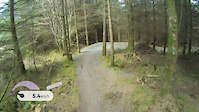
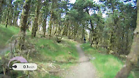
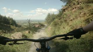
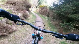
Photos of Ballyhoura Mountain Bike
Videos of Ballyhoura Mountain Bike
trail: Tech Loop 2
4:58 |
325 |
Dec 20, 2016
trail: Tech Section 1
6:09 |
293 |
Dec 20, 2016
trail: Greenwood Loop
3:32 |
1011 |
Aug 9, 2021 , Limerick
trail: Mountrussell Loop
5:30 |
1381 |
Aug 9, 2021 , Limerick
Recent Trail Reports
| status | trail | date | condition | info | user |
|---|---|---|---|---|---|
| Greenwood Loop | Aug 6, 2025 @ 1:06pm Aug 6, 2025 | Dry | cathalh | ||
| Garane 13 | Aug 6, 2025 @ 1:06pm Aug 6, 2025 | Dry | cathalh | ||
| Garane 12 | Aug 6, 2025 @ 1:06pm Aug 6, 2025 | Dry | cathalh | ||
| Garane 11 | Aug 6, 2025 @ 1:06pm Aug 6, 2025 | Dry | cathalh | ||
| Garane 10 | Aug 6, 2025 @ 1:06pm Aug 6, 2025 | Dry | cathalh | ||
| Garane 9 | Aug 6, 2025 @ 1:06pm Aug 6, 2025 | Dry | cathalh | ||
| Garane 5 | Aug 6, 2025 @ 1:06pm Aug 6, 2025 | Dry | cathalh | ||
| Red Grade - Forest Gump | Aug 6, 2025 @ 1:06pm Aug 6, 2025 | Dry | cathalh | ||
| Red Grade - Cliff Hanger | Aug 6, 2025 @ 1:06pm Aug 6, 2025 | Dry | cathalh | ||
| Garane 4 | Aug 6, 2025 @ 1:06pm Aug 6, 2025 | Dry | cathalh |
Activity Feed
| username | action | type | title | date |
|---|---|---|---|---|
| Wblazek | ridden | trail | activity #95942974 | May 31, 2026 @ 8:27am May 31, 2026 |
| Burnhardx | vote | route | activity #95109176 | May 20, 2026 @ 8:16am May 20, 2026 |
| Burnhardx | wishlist | route | activity #95109172 | May 20, 2026 @ 8:16am May 20, 2026 |
| Cmtrask | wishlist | trail | activity #91780969 | Apr 2, 2026 @ 2:10pm Apr 2, 2026 |
| jjreidy | wishlist | trail | activity #89851720 | Mar 2, 2026 @ 11:34am Mar 2, 2026 |
Recent Comments
| username | type | title | comment | date |
|---|---|---|---|---|
| trail | Good trail. Mostly rock steps and rock trail.... | Sep 12, 2025 @ 4:06am Sep 12, 2025 | ||
| trail | Best trail on the park | Jun 8, 2020 @ 2:22pm Jun 8, 2020 | ||
| trail | Fast flowing tight trail with a tricky left... | Jun 8, 2020 @ 2:21pm Jun 8, 2020 |
Nearby Areas
| name | distance | ||||
|---|---|---|---|---|---|
| Ballinaboola | 3.8 km | ||||
| Cratloe | 6 | 28.2 km | |||
| Naggles mountains | 29.4 km | ||||
| Curragh Woods | 3 | 1 | 29.5 km | ||
| Keeper Hill | 1 | 30 km |
Local Badges
-

Completionist0 awarded
Activity Type Stats
| activitytype | trails | distance | descent | descent distance | total vertical | rating | global rank | state rank | photos | reports | routes | ridelogs |
|---|---|---|---|---|---|---|---|---|---|---|---|---|
| Mountain Bike | 68 | 39 miles | 7,487 ft | 21 miles | 1,030 ft | #1,185 | #7 | 32 | 91 | 10 | 2,268 | |
| E-Bike | 47 | 23 miles | 4,117 ft | 12 miles | 1,030 ft | #906 | #9 | 79 | 8 | 442 | ||
| Hike | 54 | 32 miles | 5,079 ft | 16 miles | 1,030 ft | #1,240 | #6 | 85 | 23 | |||
| Trail Running | 54 | 32 miles | 5,079 ft | 16 miles | 1,030 ft | #699 | #6 | 85 | 11 |
Frequently Asked Questions About Ballyhoura
▼
What are the highest rated mountain biking trails in Ballyhoura?
The highest rated mountain biking trails in Ballyhoura are:
- Tech Section 1 (4.3/5)
- Tech Loop 2 (4.2/5)
- Mountrussell Loop (4.2/5)
- Freebird (4.1/5)
- Red 2 (4/5)
▼
What is the best time of the year to ride in Ballyhoura?
Based on ride log data, the most popular months to ride in Ballyhoura are:
- August (20 activities)
- June (18 activities)
- July (13 activities)
▼
Where can I park to ride in Ballyhoura?
There are 2 parking locations listed in Ballyhoura. The most popular parking spots are:
▼
What is the longest trail in Ballyhoura?
The longest trail in Ballyhoura is Mountrussell Loop at 11.6 km. View all trails sorted by distance.
Activities
- By NotDannyHart & contributors
- Admins: apply
- #10267 - 11,188 views
- ballyhoura activity log | embed map of Ballyhoura mountain bike trails | ballyhoura mountain biking points of interest
Downloading of trail gps tracks in kml & gpx formats is enabled for Ballyhoura.
You must login to download files.