close
-
Layers w
- Weather Layers
- Pro
- Pro
- Pro
- Pro
- Pro
- Pro
- More Layers
- Pro
- Pro
- Pro
- Pro
-
Upgrade to

3D
Trail Conditions
- Unknown
- Snow Groomed
- Snow Packed
- Snow Covered
- Snow Cover Partial
- Freeze/thaw Cycle
- Icy
- Prevalent Mud
- Wet
- Variable
- Ideal
- Dry
- Very Dry
Trail Flow (Ridden Direction)
Trailforks scans users ridelogs to determine the most popular direction each trail is ridden. A good flowing trail network will have most trails flowing in a single direction according to their intension.
The colour categories are based on what percentage of riders are riding a trail in its intended direction.
The colour categories are based on what percentage of riders are riding a trail in its intended direction.
- > 96%
- > 90%
- > 80%
- > 70%
- > 50%
- < 50%
- bi-directional trail
- no data
Trail Last Ridden
Trailforks scans ridelogs to determine the last time a trail was ridden.
- < 2 days
- < 1 week
- < 2 weeks
- < 1 month
- < 6 months
- > 6 months
Trail Ridden Direction
The intended direction a trail should be ridden.
- Downhill Only
- Downhill Primary
- Both Directions
- Uphill Primary
- Uphill Only
- One Direction
Contribute Details
Colors indicate trail is missing specified detail.
- Description
- Photos
- Description & Photos
- Videos
Trail Popularity ?
Trailforks scans ridelogs to determine which trails are ridden the most in the last 9 months.
Trails are compared with nearby trails in the same city region with a possible 25 colour shades.
Think of this as a heatmap, more rides = more kinetic energy = warmer colors.
- most popular
- popular
- less popular
- not popular
ATV/ORV/OHV Filter
Max Vehicle Width
inches
US Cell Coverage
Legend

Radar Time
Activity Recordings
Trailforks uses anonymized public activity data.
?
Activity Recordings
Trailforks uses anonymized public activity data.
?
Personal Heatmap
▶
Activity Types
all
/
none
▶
Options
2
Date range
month
–
Winter Trails
Warning
A routing network for winter maps does not exist. Selecting trails using the winter trails layer has been disabled.
Missing Trails
Most Popular
Least Popular
Trails are colored based on popularity. The more popular a trail is, the more red. Less popular trails trend towards green.
Jump Magnitude Heatmap
Heatmap of where riders jump on trails. Zoom in to see individual jumps, click circles to view jump details.
BC Backroad Status
![map legend]()
Service Road Atlas is a free to use, community-driven service for viewing and creating reports on the numerous back-country service roads around B.C. and Alberta.

Slope Aspect
Direction the slope faces
Trails Deemphasized
Trails are shown in grey.
Only show trails with no bike usage.
Suggested Layers
Based on selected activity type
Save the current map location and zoom level as your default home location whenever this page is loaded.
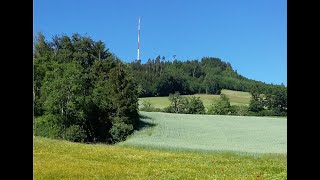
SaveSingletrail Network in the NE of Berne. Some nice MTB-Tours into Emmental start from here.
Primary Trail Type: All-Mountain & Downhill
AKA: Lutzere
Land Status: Community Forest
 google parking directions
 Access Info:
Cars can be parked at the "Bantiger-Parkplatz" below the village of Bantigen. It's even easier to access the region by public transportation (RBS-Train) or with your Bike coming from the Village Ostermundigen.
Links
This region uses the Uk/Euro style trail grading system.
Activities Click to view
- Mountain Bike
7 trails
- E-Bike
8 trails
- Hike
10 trails
- Trail Running
10 trails
Region Details
- 2
- 2
- 1
- 1
- 1
Region Status
Open as of May 21, 2026Stats
- Avg Trail Rating
- Trails (view details)
- 9
- Trails Mountain Bike
- 8
- Trails E-Bike
- 8
- Trails Hike
- 10
- Trails Trail Running
- 10
- Total Distance
- 4 miles
- Total Descent
- 2,096 ft
- Total Vertical
- 726 ft
- Highest Trailhead
- 3,099 ft
- Reports
- 125
- Photos
- 14
- Ridden Counter
- 688
Popular Bantiger Mountain Biking Trails
• 5 ★ 4.0 • 1 mile • 63 ft • 161 •
Singletrail (Wanderweg) vom Bantiger in Richtung Krauchthal. Technische Elemente: Wurzelteppiche, ausgefahrenen Rinnen, Stufen (Treppen). Gefahren: Armierungseisen, teilweise stark exponiert! Hinweise: Der Trail kreuzt zwei mal den...
• 70 ★ 4.4 • 2,395 ft • 3 ft • 108 •
Nice Singletrail heading from Bantiger Antenna down to Ferenberg. The Trail is a old hiking trail, so be aware of armours like steel-pins that might be washed out were staircases are built in to the trail. Following this trail you will...
• 50 ★ 4.0 • 988 ft • 0 ft • 81 •
Ausgesetzter Singletrail mit kurzer, sehr steiler Wurzelteppich-Passage.
• 45 ★ 4.0 • 1,299 ft • 0 ft • 65 •
Moderately popular green difficulty singletrack. This multi-use trail can be used both directions and has a moderate overall physical rating with a 0 ft black diamond climb. On average it takes 1 minutes to complete this trail.
• 60 ★ 4.7 • 1,076 ft • 0 ft • 57 •
Kurze steilere alternative zur " " - spassige technische Elemente wie Stufen, Treppen und Natürliche Hindernisse. Achtung hat teilweise auch noch Metallstifte! Trail ist relativ ausgefahren und im Sommer ein wenig verwachsen.
• 40 ★ 3.0 • 951 ft • 0 ft • 49 •
Kurzes Stück eingewachsener Waldweg in Fall-Linie - eher eine Abkürzungs-Herausforderung zum Hochpedalieren...
Photos of Bantiger Mountain Bike
Videos of Bantiger Mountain Bike

trail: Wurzel Kante
5:16 |
1038 |
Jul 6, 2020 , Bolligen
trail: Chatzestyg
5:16 |
560 |
Jul 6, 2020 , Bolligen
Recent Trail Reports
| status | trail | date | condition | info | user |
|---|---|---|---|---|---|
| Möslihole | May 21, 2026 @ 6:09pm (Europe/Zurich) May 21, 2026 | Prevalent Mud | ScreamXY | ||
| Stotzgrotze | Apr 17, 2026 @ 12:55pm (Europe/Zurich) Apr 17, 2026 | Dry | ScreamXY | ||
| Zwyflue | Apr 17, 2026 @ 12:55pm (Europe/Zurich) Apr 17, 2026 | Dry | ScreamXY | ||
| Chatzestyg | Apr 7, 2026 @ 6:57pm (Europe/Zurich) Apr 7, 2026 | Variable | Alkabi | ||
| Wurzel Kante | Apr 7, 2026 @ 6:57pm (Europe/Zurich) Apr 7, 2026 | Variable | Alkabi | ||
| Bantriple | Apr 7, 2026 @ 6:57pm (Europe/Zurich) Apr 7, 2026 | Variable | Alkabi | ||
| Mösliacher Climb (FSR) | Jun 9, 2022 @ 8:41am Jun 9, 2022 | Variable | Switish |
Activity Feed
| username | action | type | title | date |
|---|---|---|---|---|
| ScreamXY | vote | trail | activity #95491947 | May 25, 2026 @ 8:37am May 25, 2026 |
| ScreamXY | add | report | activity #95227349 | May 22, 2026 @ 12:53am May 22, 2026 |
| ScreamXY | add | report | activity #92785102 and 1 more | Apr 17, 2026 @ 7:06am Apr 17, 2026 |
| fd0jDB | ridden | trail | activity #92705928 | Apr 15, 2026 @ 10:53pm Apr 15, 2026 |
| Alkabi | add | report | activity #92233714 and 2 more | Apr 8, 2026 @ 9:17pm Apr 8, 2026 |
Recent Comments
| username | type | title | comment | date |
|---|---|---|---|---|
| report | Definitiv unlustig der Stotzgrotzen. | May 16, 2020 @ 4:36am May 16, 2020 | ||
| report | Yes, and there is a "fence" that you will have... | Aug 15, 2019 @ 12:15pm Aug 15, 2019 | ||
| report | @danpetersson is there a sign that says it's... | Aug 15, 2019 @ 1:25am Aug 15, 2019 |
Nearby Areas
| name | distance | ||||
|---|---|---|---|---|---|
| Schwarzchopf | 3 | 3 | 1.7 km | ||
| Ostermundigeberg | 4 | 2.5 km | |||
| Denteberg | 2 | 2.8 km | |||
| Gurten | 4 | 8 | 5.8 km | ||
| Chünizberg | 17 | 6.7 km |
Activity Type Stats
| activitytype | trails | distance | descent | descent distance | total vertical | rating | global rank | state rank | photos | reports | routes | ridelogs |
|---|---|---|---|---|---|---|---|---|---|---|---|---|
| Mountain Bike | 7 | 3 miles | 1,342 ft | 2 miles | 725 ft | #4,385 | #73 | 13 | 128 | 662 | ||
| E-Bike | 8 | 3 miles | 1,342 ft | 2 miles | 725 ft | #2,900 | #68 | 1 | 118 | 63 | ||
| Hike | 10 | 4 miles | 2,096 ft | 3 miles | 725 ft | #3,925 | #61 | 128 | 32 | |||
| Trail Running | 10 | 4 miles | 2,096 ft | 3 miles | 725 ft | #3,152 | #53 | 128 | 32 |
Frequently Asked Questions About Bantiger
▼
What are the highest rated mountain biking trails in Bantiger?
The highest rated mountain biking trails in Bantiger are:
- Chatzestyg (4.2/5)
- Wurzel Kante (4.1/5)
- Möslihole (4/5)
- Zwyflue (4/5)
- Bantriple (4/5)
▼
What is the best time of the year to ride in Bantiger?
Based on ride log data, the most popular months to ride in Bantiger are:
- February (9 activities)
- March (8 activities)
- April (5 activities)
▼
Where can I park to ride in Bantiger?
There are 2 parking locations listed in Bantiger. The most popular parking spots are:
▼
What is the longest trail in Bantiger?
The longest trail in Bantiger is Bantriple at 1.0 mile. View all trails sorted by distance.
Activities
Trails
Points of Interest
- By AlpineTracker
 & contributors
 - Admins: Trailnet Bern, daflow17, paraenggu
- #14545 - 5,664 views
- bantiger activity log | embed map of Bantiger mountain bike trails | bantiger mountain biking points of interest
Downloading of trail gps tracks in kml & gpx formats is enabled for Bantiger.
You must login to download files.