close
-
Layers w
- Weather Layers
- Pro
- Pro
- Pro
- Pro
- Pro
- Pro
- More Layers
- Pro
- Pro
- Pro
- Pro
-
Upgrade to

3D
Trail Conditions
- Unknown
- Snow Groomed
- Snow Packed
- Snow Covered
- Snow Cover Partial
- Freeze/thaw Cycle
- Icy
- Prevalent Mud
- Wet
- Variable
- Ideal
- Dry
- Very Dry
Trail Flow (Ridden Direction)
Trailforks scans users ridelogs to determine the most popular direction each trail is ridden. A good flowing trail network will have most trails flowing in a single direction according to their intension.
The colour categories are based on what percentage of riders are riding a trail in its intended direction.
The colour categories are based on what percentage of riders are riding a trail in its intended direction.
- > 96%
- > 90%
- > 80%
- > 70%
- > 50%
- < 50%
- bi-directional trail
- no data
Trail Last Ridden
Trailforks scans ridelogs to determine the last time a trail was ridden.
- < 2 days
- < 1 week
- < 2 weeks
- < 1 month
- < 6 months
- > 6 months
Trail Ridden Direction
The intended direction a trail should be ridden.
- Downhill Only
- Downhill Primary
- Both Directions
- Uphill Primary
- Uphill Only
- One Direction
Contribute Details
Colors indicate trail is missing specified detail.
- Description
- Photos
- Description & Photos
- Videos
Trail Popularity ?
Trailforks scans ridelogs to determine which trails are ridden the most in the last 9 months.
Trails are compared with nearby trails in the same city region with a possible 25 colour shades.
Think of this as a heatmap, more rides = more kinetic energy = warmer colors.
- most popular
- popular
- less popular
- not popular
ATV/ORV/OHV Filter
Max Vehicle Width
inches
US Cell Coverage
Legend

Radar Time
Activity Recordings
Trailforks uses anonymized public activity data.
?
Activity Recordings
Trailforks uses anonymized public activity data.
?
Personal Heatmap
▶
Activity Types
all
/
none
▶
Options
2
Date range
month
–
Winter Trails
Warning
A routing network for winter maps does not exist. Selecting trails using the winter trails layer has been disabled.
Missing Trails
Most Popular
Least Popular
Trails are colored based on popularity. The more popular a trail is, the more red. Less popular trails trend towards green.
Jump Magnitude Heatmap
Heatmap of where riders jump on trails. Zoom in to see individual jumps, click circles to view jump details.
BC Backroad Status
![map legend]()
Service Road Atlas is a free to use, community-driven service for viewing and creating reports on the numerous back-country service roads around B.C. and Alberta.

Slope Aspect
Direction the slope faces
Trails Deemphasized
Trails are shown in grey.
Only show trails with no bike usage.
Suggested Layers
Based on selected activity type
Save the current map location and zoom level as your default home location whenever this page is loaded.
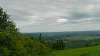
SaveThe Bas-Saint-Laurent (Lower Saint-Lawrence) region is located along the south shore of the lower Saint Lawrence River in Quebec. The river widens at this place and became farther a bay who discharges itself in the sea and is often nicknamed "Bas-du-Fleuve" (Lower-River). The region is formed by 8 regional county municipalities and 114 municipalities.
It has a population of 199,977[1] and a land area of 22,234.10km².
Its geography is marked by the Saint Lawrence River to the northwest, the Notre Dame Mountains section of the Appalachians, as well as the Matapédia and Témiscouata valleys, which form the natural communication corridors with the Gaspé Peninsula, Maine, and the Maritimes.
source: Bas-St-Laurent
AKA: Lower St-Lawrence, Bas-du-Fleuve
Region Details
- 39
- 4
- 78
- 82
- 55
- 16
- 1
Local Trail Association
Stats
- Avg Trail Rating
- Trails (view details)
- 461
- Trails Mountain Bike
- 277
- Trails E-Bike
- 127
- Trails Gravel Bike
- 26
- Trails Adaptive Bike
- 25
- Trails Winter Fat Bike
- 51
- Trails Hike
- 208
- Trails Trail Running
- 204
- Trails Dirtbike/Moto
- 1
- Trails ATV/ORV/OHV
- 3
- Trails Snowmobile
- 6
- Trails Snowshoe
- 44
- Trails Downhill Ski
- 2
- Trails Nordic Ski
- 62
- Total Distance
- 512 miles
- Total Descent
- 48,709 ft
- Total Vertical
- 2,239 ft
- Highest Trailhead
- 2,247 ft
- Reports
- 912
- Photos
- 638
- Ridden Counter
- 18,354
Articles
jerome gagnon in Mont-Joli, Quebec, Canada - photo by mikejonssantacruz
Dec 29, 2022 from pinkbike.com
Photo of jerome gagnon in Mont-Joli, Quebec, Canada. carte des sentiers du mont-comi , 2017 merci au bénévoles
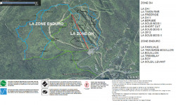
Popular Trail Networks
view all areas »Sub Regions
- Degelis (10)
- La Pocatière (44)
- Boisé Beaupré (44)
- Matane (37)
- Mont-Joli (25)
- Parc du Mont-Comi (24)
- Notre-Dame-du-Portage (12)
- Sentiers du Portage (22)
- Rimouski (60)
- Rivière-du-Loup (50)
- Sainte-Irène (35)
- Trois-Pistoles (10)
- Club Sportif Appalaches (1)
- Lac Adele (1)
Popular Bas-St-Laurent Mountain Biking Trails
• 95 ★ 4.2 • 2 miles • 58 ft • 331 •
Highly rated popular blue difficulty singletrack. This mountain bike primary trail can be used downhill primary and has a moderate overall physical rating with a 58 ft blue climb. On average it takes 15 minutes to complete this trail.
• 90 ★ 4.5 • 1,247 ft • 0 ft • 236 •
Highly rated popular black diamond difficulty singletrack. This mountain bike primary trail can be used downhill only and has a hard overall physical rating with a 0 ft black diamond climb. It features berm, drop and roller coaster. On average it takes 2 minutes to complete this trail.
• 100 ★ 4.0 • 3,054 ft • 212 ft • 227 •
Popular blue difficulty singletrack. This mountain bike primary trail can be used uphill only and has a hard overall physical rating with a 212 ft black diamond climb. On average it takes 7 minutes to complete this trail.
• 100 ★ 4.9 • 2,126 ft • 0 ft • 225 •
Highly rated popular black diamond difficulty singletrack. This mountain bike primary trail can be used downhill only and has a hard overall physical rating with a 0 ft black diamond climb. It features berm and drop. On average it takes 7 minutes to complete this trail.
• 90 ★ 4.8 • 1,716 ft • 0 ft • 189 •
Popular black diamond difficulty singletrack. This mountain bike primary trail can be used downhill only and has a hard overall physical rating with a 0 ft black diamond climb. It features berm, drop and jump. On average it takes 8 minutes to complete this trail.
• 80 ★ 4.4 • 1,273 ft • 3 ft • 188 •
Popular black diamond difficulty singletrack. This mountain bike primary trail can be used downhill only and has a hard overall physical rating with a 3 ft black diamond climb. It features berm, drop and jump. On average it takes 3 minutes to complete this trail.
• 85 ★ 4.9 • 1 mile • 0 ft • 165 •
Découvrez ou redécouvrez, la star incontestée de nos sentiers ! Remise à neuf pour 2025, cette piste machine built offre un flow incomparable, de la vitesse, des berms et des rollers spectaculaires . Que vous fassiez vos premiers...
Bas-St-Laurent Mountain Bike Routes
26 miles • 1,255 ft • 0 • Loop •
Gravel 42km Boucle Grotte des Fées St-Damase Lac des Îles
• 6 miles • 888 ft • 19 •
• 10 miles • 1,884 ft • 39 •
• 8 miles • 2,806 ft • 8 •
• 7 miles • 1,240 ft • 32 •
• 12 miles • 954 ft • 19 •
Photos of Bas-St-Laurent Mountain Bike
Videos of Bas-St-Laurent Mountain Bike
Recent Trail Reports
Activity Feed
| username | action | type | title | date |
|---|---|---|---|---|
| padipad | ridden | trail | activity #97367957 | Jun 19, 2026 @ 11:11pm 2 days |
| Yannnn | update | trail | activity #97355355 and 2 more | Jun 19, 2026 @ 5:18pm 2 days |
| Yannnn | add | photo | activity #97354123 and 10 more | Jun 19, 2026 @ 4:56pm 2 days |
| vegetox | wishlist | region | activity #97339727 | Jun 19, 2026 @ 1:02pm 2 days |
| mont-sainte-anne | wishlist | region | activity #97338256 | Jun 19, 2026 @ 12:39pm 2 days |
Recent Comments
| username | type | title | comment | date |
|---|---|---|---|---|
| report | Très beau sauts pour progresser. Bien... | Sep 12, 2025 @ 4:47pm Sep 12, 2025 | ||
| report | Le sentier viens d'ouvrir c'est vraiment très... | Sep 12, 2025 @ 12:37pm Sep 12, 2025 | ||
| trail | Sauts parfait pour progresser. Ils peuvent... | Aug 3, 2025 @ 2:16pm Aug 3, 2025 | ||
| trail | Superbe courte piste de descente. Le step up... | Aug 15, 2024 @ 8:28pm Aug 15, 2024 | ||
| trail | Semblable à Sidewinder dans Kingdom Trails... | Sep 4, 2023 @ 2:23pm Sep 4, 2023 |
Local Badges
-

Top 10 Trails3 awarded -

Epic Ride 50k24 awarded -
Epic Ride 50k104 awarded -
Top 10 Trails1 awarded -

Completionist1 awarded -

Epic Ride Climb 2k0 awarded
Bike & Skill Parks
| name | type | city | rating |
|---|---|---|---|
| Parc du Mont-Comi | bike park | Mont-Joli | |
| Parc du Mont Saint-Mathieu | bike park | Trois-Pistoles | |
| Pumptrack Parc Beauséjour | skill park | Rimouski | |
| Parc d'Habiletés - Boisé Beaupré | skill park | La Pocatière | |
| Parc d'habileté Laser ProVue | skill park | Rimouski |
Activity Type Stats
| activitytype | trails | distance | descent | descent distance | total vertical | rating | global rank | state rank | photos | reports | routes | ridelogs |
|---|---|---|---|---|---|---|---|---|---|---|---|---|
| Mountain Bike | 277 | 323 miles | 34,213 ft | 145 miles | 2,238 ft | 653 | 911 | 1 | 14,347 | |||
| E-Bike | 127 | 249 miles | 25,558 ft | 118 miles | 2,215 ft | 759 | 1 | 887 | ||||
| Gravel Bike | 26 | 110 miles | 4,892 ft | 43 miles | 2,215 ft | 57 | 1 | 178 | ||||
| Adaptive Bike | 25 | 29 miles | 1,050 ft | 7 miles | 856 ft | 79 | ||||||
| Winter Fat Bike | 51 | 34 miles | 2,867 ft | 11 miles | 574 ft | 1 | 120 | 119 | ||||
| Hike | 208 | 328 miles | 18,192 ft | 131 miles | 2,218 ft | 846 | 1,363 | |||||
| Trail Running | 204 | 325 miles | 16,483 ft | 128 miles | 2,218 ft | 842 | 1,192 | |||||
| Dirtbike/Moto | 1 | 1 mile | 85 ft | 1 | 246 | |||||||
| ATV/ORV/OHV | 3 | 3 miles | 39 ft | 2,582 ft | 285 ft | 246 | 57 | |||||
| Snowmobile | 6 | 6 miles | 413 ft | 2 miles | 1,621 ft | 4 | 5 | |||||
| Snowshoe | 44 | 41 miles | 4,193 ft | 15 miles | 1,860 ft | 183 | 215 | |||||
| Downhill Ski | 2 | 1 mile | 26 ft | 837 ft | 177 ft | 145 | 737 | |||||
| Nordic Ski | 62 | 104 miles | 5,817 ft | 36 miles | 1,775 ft | 148 | 1,183 |
Activities
- Bas-St-Laurent Mountain Biking Trails
- Bas-St-Laurent E-Biking Trails
- Bas-St-Laurent Gravel Biking Trails
- Bas-St-Laurent Adaptive Biking Trails
- Bas-St-Laurent Winter Fat Biking Trails
- Bas-St-Laurent Hiking Trails
- Bas-St-Laurent Trail Running Trails
- Bas-St-Laurent Snowmobiling Trails
- Bas-St-Laurent Snowshoeing Trails
- Bas-St-Laurent Nordic Skiing Trails
Trails
Points of Interest
- Sentier du Jardin Viewpoint
- WiFi Other
- Haite du Nordet Viewpoint
- Hiate du Suroit Viewpoint
- Sentier de la Corniche Viewpoint
- Sentier de la Corniche Viewpoint
- Camping de l'Anse a la Boule
- Camping Les Belugas
- Pointe Ouest Viewpoint
- Anse aux Epervieres Viewpoint
- Val d'Irène (2,234 ft)
- Montagne de la Tour (2,215 ft)
- Montagne des Cinq Milles (2,113 ft)
- By Bricklin69
 & contributors
 - Admins: VQ, bigjay, StephaneMarceau, Canadmos
- #5805 - 8,915 views
- bas-st-laurent activity log | embed map of Bas-St-Laurent mountain bike trails | bas-st-laurent mountain biking points of interest
Downloading of trail gps tracks in kml & gpx formats is enabled for Bas-St-Laurent.
You must login to download files.