close
-
Layers w
- Weather Layers
- Pro
- Pro
- Pro
- Pro
- Pro
- Pro
- More Layers
- Pro
- Pro
- Pro
- Pro
-
Upgrade to

3D
Trail Conditions
- Unknown
- Snow Groomed
- Snow Packed
- Snow Covered
- Snow Cover Partial
- Freeze/thaw Cycle
- Icy
- Prevalent Mud
- Wet
- Variable
- Ideal
- Dry
- Very Dry
Trail Flow (Ridden Direction)
Trailforks scans users ridelogs to determine the most popular direction each trail is ridden. A good flowing trail network will have most trails flowing in a single direction according to their intension.
The colour categories are based on what percentage of riders are riding a trail in its intended direction.
The colour categories are based on what percentage of riders are riding a trail in its intended direction.
- > 96%
- > 90%
- > 80%
- > 70%
- > 50%
- < 50%
- bi-directional trail
- no data
Trail Last Ridden
Trailforks scans ridelogs to determine the last time a trail was ridden.
- < 2 days
- < 1 week
- < 2 weeks
- < 1 month
- < 6 months
- > 6 months
Trail Ridden Direction
The intended direction a trail should be ridden.
- Downhill Only
- Downhill Primary
- Both Directions
- Uphill Primary
- Uphill Only
- One Direction
Contribute Details
Colors indicate trail is missing specified detail.
- Description
- Photos
- Description & Photos
- Videos
Trail Popularity ?
Trailforks scans ridelogs to determine which trails are ridden the most in the last 9 months.
Trails are compared with nearby trails in the same city region with a possible 25 colour shades.
Think of this as a heatmap, more rides = more kinetic energy = warmer colors.
- most popular
- popular
- less popular
- not popular
ATV/ORV/OHV Filter
Max Vehicle Width
inches
US Cell Coverage
Legend

Radar Time
Activity Recordings
Trailforks uses anonymized public activity data.
?
Activity Recordings
Trailforks uses anonymized public activity data.
?
Personal Heatmap
▶
Activity Types
all
/
none
▶
Options
2
Date range
month
–
Winter Trails
Warning
A routing network for winter maps does not exist. Selecting trails using the winter trails layer has been disabled.
Missing Trails
Most Popular
Least Popular
Trails are colored based on popularity. The more popular a trail is, the more red. Less popular trails trend towards green.
Jump Magnitude Heatmap
Heatmap of where riders jump on trails. Zoom in to see individual jumps, click circles to view jump details.
BC Backroad Status
![map legend]()
Service Road Atlas is a free to use, community-driven service for viewing and creating reports on the numerous back-country service roads around B.C. and Alberta.

Slope Aspect
Direction the slope faces
Trails Deemphasized
Trails are shown in grey.
Only show trails with no bike usage.
Suggested Layers
Based on selected activity type
Save the current map location and zoom level as your default home location whenever this page is loaded.
SaveLa zona dove sono situati i sentieri è un area forestale chiamata Monte Leoni (dal monte che si eleva maggiormente nell'area), utilizzata per il taglio della legna e la caccia, ma è molto frequentata anche da motociclisti e riders in bici, ci sono svariati sentieri che formano degli anelli. E' un area ideale per le ebike data la verietà di sentieri e le pendenze importanti che si possono trovare nelle risalite.
This region uses the Uk/Euro style trail grading system.
Activities Click to view
- Mountain Bike
54 trails
- E-Bike
31 trails
- Gravel Bike
0 trails
- Adaptive Bike
0 trails
- Horse
5 trails
- Hike
47 trails
- Trail Running
51 trails
- Dirtbike/Moto
10 trails
- ATV/ORV/OHV
0 trails
Region Details
- 16
- 9
- 13
Region Status
Caution as of May 24, 2026Stats
- Avg Trail Rating
- Trails (view details)
- 40
- Trails Mountain Bike
- 54
- Trails E-Bike
- 31
- Trails Horse
- 5
- Trails Hike
- 47
- Trails Trail Running
- 51
- Trails Dirtbike/Moto
- 10
- Total Distance
- 41 miles
- Total Descent
- 11,854 ft
- Total Vertical
- 1,835 ft
- Highest Trailhead
- 1,952 ft
- Reports
- 348
- Photos
- 80
- Ridden Counter
- 563
Popular Batignano Mountain Biking Trails
• 95 ★ 4.0 • 1,539 ft • 0 ft • 32 •
La parte bassa dello storico singletrack di , rimasta dopo la chiusura della prima parte; adesso è utilizzato in entrambe le direzioni, tecnicamente molto semplice sia in salita che in discesa.
• 90 ★ 3.0 • 3,084 ft • 0 ft • 15 •
Scorrevole e velocissimo! Con qualche salto e un punto più tecnico per il fondo sconnesso.
• 80 ★ 0.0 • 2,096 ft • 6 ft • 14 •
Un vecchio sentiero di caccia con pendenze minime e senza tratti tecnici, ottimo sia in salita che in discesa
• 95 ★ 0.0 • 3,291 ft • 16 ft • 14 •
Popular green difficulty singletrack. This mountain bike primary trail can be used downhill only and has a moderate overall physical rating. It features jump and wallride. Trail visibility is always easy to follow. On average it takes 6 minutes to complete this trail.
• 55 ★ 5.0 • 2,159 ft • 6 ft • 10 •
Sentiero sviluppato nella lecceta di Poggio Cornocchio, pieno di curve, molto scorrevole e adatto a tutti; è possibile imboccare soltanto la parte finale del trail (la traccia originale) come alternativa allo strada principale.
• 80 ★ 0.0 • 2,169 ft • 0 ft • 8 •
Un sentiero dei cacciatori adattato e preparato per le mtb, pendenze minime, molto scorrevole, solo il tratto centrale spezza un po' il ritmo con qualche curva stretta. La traccia è un po' stretta e per andare forte serve precisione...
• 90 ★ 3.0 • 2,598 ft • 0 ft • 8 •
Lo storico singletrack della zona, risistemato dopo anni di abbandono per via del disboscamento; velocissimo e ripido, con nuove linee e nuovi salti.
• 60 ★ 3.0 • 1 mile • 0 ft • 8 •
Moderately popular blue difficulty singletrack. This multi-use trail can be used downhill primary. It features berm and rock face. On average it takes 13 minutes to complete this trail.
Photos of Batignano Mountain Bike
Videos of Batignano Mountain Bike
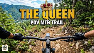
trail: The Queen of Monte Leoni
8:40 |
12 |
Mar 1, 2026 , Batignano
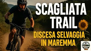
trail: Scagliata 1
6:10 |
10 |
Feb 7, 2026 , Batignano
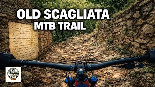
trail: Scagliata 1
3:06 |
12 |
Feb 7, 2026 , Batignano

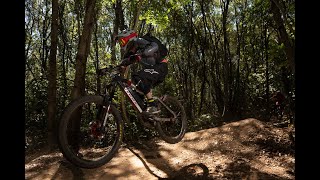
trail: Il Soldato
41 |
Jun 10, 2025 , Batignano

trail: Il Soldato
48 |
Jun 10, 2025 , Batignano
trail: L'Infermiera
6:22 |
43 |
May 13, 2025 , Batignano

trail: Cornocchio Trail
5:36 |
56 |
May 6, 2025 , Batignano
trail: Scagliata 1
4:11 |
33 |
Apr 14, 2025 , Batignano
Recent Trail Reports
| status | trail | date | condition | info | user |
|---|---|---|---|---|---|
| Cornocchio Trail | May 25, 2026 @ 7:44am (Europe/Rome) May 24, 2026 | Very Dry | ethan28 | ||
| 777 Trail | Apr 12, 2026 @ 9:23am (Europe/Vatican) Apr 12, 2026 | Variable | MaremmaTrailTUBE | ||
| The Cave trail | Apr 12, 2026 @ 9:23am (Europe/Vatican) Apr 12, 2026 | Dry | MaremmaTrailTUBE | ||
| The Queen of Monte Leoni lower | Apr 12, 2026 @ 9:23am (Europe/Vatican) Apr 12, 2026 | Ideal | MaremmaTrailTUBE | ||
| The Queen of Monte Leoni | Apr 12, 2026 @ 9:23am (Europe/Vatican) Apr 12, 2026 | Ideal | MaremmaTrailTUBE | ||
| Kaccirillo | Apr 12, 2026 @ 9:23am (Europe/Vatican) Apr 12, 2026 | Variable | MaremmaTrailTUBE | ||
| Wild Boar singletrack | Apr 12, 2026 @ 9:23am (Europe/Vatican) Apr 12, 2026 | Ideal | MaremmaTrailTUBE | ||
| Scagliata Maremma Freeride | Apr 12, 2026 @ 9:23am (Europe/Vatican) Apr 12, 2026 | Ideal | MaremmaTrailTUBE | ||
| Scagliata 1 | Apr 12, 2026 @ 9:23am (Europe/Vatican) Apr 12, 2026 | Ideal | MaremmaTrailTUBE | ||
| Il Soldato | Apr 12, 2026 @ 9:23am (Europe/Vatican) Apr 12, 2026 | Ideal | MaremmaTrailTUBE |
Activity Feed
| username | action | type | title | date |
|---|---|---|---|---|
| ethan28 | add | report | activity #95466712 | May 24, 2026 @ 10:44pm May 24, 2026 |
| MaremmaTrailTUBE | vote | trail | activity #93718186 | Apr 30, 2026 @ 9:31am Apr 30, 2026 |
| MaremmaTrailTUBE | add | photo | activity #93718101 | Apr 30, 2026 @ 9:30am Apr 30, 2026 |
| ethan28 | add | trail | activity #93336451 | Apr 25, 2026 @ 2:49am Apr 25, 2026 |
| morixx | wishlist | region | activity #93083677 | Apr 21, 2026 @ 8:50am Apr 21, 2026 |
Recent Comments
| username | type | title | comment | date |
|---|---|---|---|---|
| trail | Oki doki, grazie mille ☺️ | Apr 12, 2024 @ 1:01pm Apr 12, 2024 | ||
| trail | si infatti. la mia intenzione era quella di... | Apr 12, 2024 @ 6:52am Apr 12, 2024 | ||
| trail | questo commento sarebbe più appropriato come... | Apr 12, 2024 @ 5:46am Apr 12, 2024 | ||
| trail | sistemata la vegetazione. Il sentiero è ok!! | Apr 11, 2024 @ 2:47pm Apr 11, 2024 | ||
| report | Anche il fondo è stato ripulito dalle foglie | Apr 9, 2024 @ 9:55am Apr 9, 2024 |
Local Badges
-

Epic Ride Climb 2k31 awarded -

Climbing 10k Badge14 awarded -

Climbing 100k Badge0 awarded -

Epic Ride Descent 2k41 awarded -

Descent 10k Badge14 awarded -

Descent 100k Badge0 awarded
Bike & Skill Parks
| name | type | city | rating |
|---|---|---|---|
| borgo santa rita | skill park | Batignano |
Activity Type Stats
| activitytype | trails | distance | descent | descent distance | total vertical | rating | global rank | state rank | photos | reports | routes | ridelogs |
|---|---|---|---|---|---|---|---|---|---|---|---|---|
| Mountain Bike | 54 | 41 miles | 11,854 ft | 23 miles | 1,834 ft | #3,875 | #232 | 80 | 346 | 1,977 | ||
| E-Bike | 31 | 19 miles | 8,314 ft | 14 miles | 1,801 ft | #4,148 | #393 | 297 | 308 | |||
| Horse | 5 | 3,084 ft | 315 ft | 3,018 ft | 315 ft | #2,197 | #142 | 23 | ||||
| Hike | 47 | 39 miles | 10,138 ft | 21 miles | 1,834 ft | #4,970 | #215 | 271 | 16 | |||
| Trail Running | 51 | 40 miles | 10,564 ft | 22 miles | 1,834 ft | #4,299 | #192 | 297 | 36 | |||
| Dirtbike/Moto | 10 | 7 miles | 3,576 ft | 7 miles | 1,663 ft | #854 | #33 | 15 |
Frequently Asked Questions About Batignano
▼
What are the highest rated mountain biking trails in Batignano?
The highest rated mountain biking trails in Batignano are:
- Boyz Trail (4.1/5)
- Scagliata Maremma Freeride (4/5)
- Fonte del Dottore Freeride (3.8/5)
- 777 Trail (0/5)
- Il Soldato (0/5)
▼
What is the best time of the year to ride in Batignano?
Based on ride log data, the most popular months to ride in Batignano are:
- July (5 activities)
- December (3 activities)
- November (2 activities)
▼
Where can I park to ride in Batignano?
Check the Batignano trail map for trailhead and parking information. Community members regularly update access and parking details for trails in the area.
▼
What is the longest trail in Batignano?
The longest trail in Batignano is La Rete at 2.0 miles. View all trails sorted by distance.
Activities
Trails
- By Stinketto
 Lumberjacks AMFR TASSO & contributors
 - Admins: DanielePracchia, Lumberjacks
- #12466 - 2,781 views
- batignano activity log | embed map of Batignano mountain bike trails | batignano mountain biking points of interest
Downloading of trail gps tracks in kml & gpx formats is enabled for Batignano.
You must login to download files.