close
-
Layers w
- Weather Layers
- Pro
- Pro
- Pro
- Pro
- Pro
- Pro
- More Layers
- Pro
- Pro
- Pro
- Pro
-
Upgrade to

3D
Trail Conditions
- Unknown
- Snow Groomed
- Snow Packed
- Snow Covered
- Snow Cover Partial
- Freeze/thaw Cycle
- Icy
- Prevalent Mud
- Wet
- Variable
- Ideal
- Dry
- Very Dry
Trail Flow (Ridden Direction)
Trailforks scans users ridelogs to determine the most popular direction each trail is ridden. A good flowing trail network will have most trails flowing in a single direction according to their intension.
The colour categories are based on what percentage of riders are riding a trail in its intended direction.
The colour categories are based on what percentage of riders are riding a trail in its intended direction.
- > 96%
- > 90%
- > 80%
- > 70%
- > 50%
- < 50%
- bi-directional trail
- no data
Trail Last Ridden
Trailforks scans ridelogs to determine the last time a trail was ridden.
- < 2 days
- < 1 week
- < 2 weeks
- < 1 month
- < 6 months
- > 6 months
Trail Ridden Direction
The intended direction a trail should be ridden.
- Downhill Only
- Downhill Primary
- Both Directions
- Uphill Primary
- Uphill Only
- One Direction
Contribute Details
Colors indicate trail is missing specified detail.
- Description
- Photos
- Description & Photos
- Videos
Trail Popularity ?
Trailforks scans ridelogs to determine which trails are ridden the most in the last 9 months.
Trails are compared with nearby trails in the same city region with a possible 25 colour shades.
Think of this as a heatmap, more rides = more kinetic energy = warmer colors.
- most popular
- popular
- less popular
- not popular
ATV/ORV/OHV Filter
Max Vehicle Width
inches
US Cell Coverage
Legend

Radar Time
Activity Recordings
Trailforks uses anonymized public activity data.
?
Activity Recordings
Trailforks uses anonymized public activity data.
?
Personal Heatmap
▶
Activity Types
all
/
none
▶
Options
2
Date range
month
–
Winter Trails
Warning
A routing network for winter maps does not exist. Selecting trails using the winter trails layer has been disabled.
Missing Trails
Most Popular
Least Popular
Trails are colored based on popularity. The more popular a trail is, the more red. Less popular trails trend towards green.
Jump Magnitude Heatmap
Heatmap of where riders jump on trails. Zoom in to see individual jumps, click circles to view jump details.
BC Backroad Status
![map legend]()
Service Road Atlas is a free to use, community-driven service for viewing and creating reports on the numerous back-country service roads around B.C. and Alberta.

Slope Aspect
Direction the slope faces
Trails Deemphasized
Trails are shown in grey.
Only show trails with no bike usage.
Suggested Layers
Based on selected activity type
Save the current map location and zoom level as your default home location whenever this page is loaded.
SaveBear's Best is the newest Cross country/All-Mountain proving grounds. Design to assist progression in local MTB community and challenge the old and new alike.
Primary Trail Type: Cross-Country
eBikes Allowed:
Yes
 google parking directions
 Access Info:
Mesa Park
Activities Click to view
- Mountain Bike
114 trails
- E-Bike
51 trails
- Hike
111 trails
- Trail Running
111 trails
Region Details
- 11
- 1
- 13
- 52
- 10
Region Status
Caution as of May 27, 2026Stats
- Avg Trail Rating
- Trails (view details)
- 87
- Trails Mountain Bike
- 115
- Trails E-Bike
- 51
- Trails Gravel Bike
- 3
- Trails Hike
- 111
- Trails Trail Running
- 111
- Total Distance
- 105 miles
- Total Descent
- 14,467 ft
- Total Vertical
- 1,199 ft
- Highest Trailhead
- 4,000 ft
- Reports
- 2,193
- Photos
- 354
- Ridden Counter
- 30,082
Popular Red Rock - Bear’s Best Mountain Biking Trails
• 100 ★ 4.2 • 4,806 ft • 5 ft • 1,313 •
This absolutely should be ridden from south to north. There are two distinct sections to this trail - the wrap around the side of a mtn which has a slight climb to mostly flat then the straight away locals have coined Permagrin....
• 100 ★ 4.3 • 4,708 ft • 99 ft • 1,274 •
This slowly climbs from the road, with a short but steep section. The trail slowly levels off until the 5-Way, where the preferred quick and fun loop is to do Permagrin. This can be ridden both ways, and is fun to drop off at the end,...
• 90 ★ 4.1 • 2 miles • 194 ft • 1,096 •
This trail is a good access trail from the to get into the canyon. It is pretty easy and just undulates across the bench. Good XC trail to get in desert miles and create a nice big loop in the area.
• 70 ★ 3.6 • 2 miles • 61 ft • 1,092 •
Popular blue difficulty singletrack. This mountain bike primary trail and has a moderate overall physical rating with a 61 ft blue climb. It features drop and jump. Exposure: Normal Injury Risk. On average it takes 14 minutes to complete this trail.
• 90 ★ 3.1 • 2 miles • 474 ft • 1,067 •
If you start on the north end and climb heading southwest this is a moderate climb with a few rocky and technical sections. The downhill flows nicely with some technical sections and drops. Do not crash, there is cactus ever where; I...
• 100 ★ 4.6 • 1 mile • 145 ft • 1,015 •
This is a flowy trail that is mostly pretty smooth. The end has some steep bermy drop down section that you have to take fast, but the trail is pretty easy. A few fast little gullies to drop down. Make sure you ride this heading west.
• 100 ★ 3.5 • 3,753 ft • 89 ft • 920 •
Paved bike path accessing the trails. Nearby dirt road is currently gated and locked.
• 95 ★ 4.3 • 2,762 ft • 76 ft • 918 •
Nice little climb up to the saddle. Slow grind up heading north and fast down. Commonly used after dropping off of or to climb up to the big intersection.
Red Rock - Bear’s Best Mountain Bike Routes
★ 4.4 • 14 miles • 1,112 ft • 18 • Loop •
This is a fairly easy loop starting and ending at McGhie's Bike outpost. Trails are in very good...
★ 5.0 • 34 miles • 3,292 ft • 12 • Loop •
30 mile loop. BearsBest - Cottonwood - LateNight
★ 5.0 • 24 miles • 2,436 ft • 47 • Loop •
want a good combination of ascend and descend? this route will give you both, some good punch climb and a...
★ 5.0 • 11 miles • 1,126 ft • 16 •
Bear's Best Access Road, connecting to Gnarley, Yellow Hoe, Round the Outside, back to the Access Road
★ 5.0 • 16 miles • 1,778 ft • 9 • Loop •
Reserved for people who like to earn their DH.
★ 4.0 • 11 miles • 895 ft • 8 • Loop •
Outer Alice to Benchmark and Perma Grin
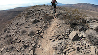
Photos of Red Rock - Bear’s Best Mountain Bike
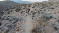
Videos of Red Rock - Bear’s Best Mountain Bike
trail: Bears Best
0:11 |
272 |
Feb 3, 2022

trail: Perma Grin
5:58 |
111 |
Oct 6, 2020
trail: Teddy Bear
4:55 |
172 |
Sep 24, 2020

trail: Outer Alice
3:20 |
307 |
Oct 13, 2019
trail: Man with a Van
6:59 |
98 |
Jan 27, 2019
trail: Goat (South)
0:48 |
164 |
Nov 20, 2018
trail: Get Schwifty
0:42 |
394 |
Nov 20, 2018
trail: Perma Grin
3:57 |
443 |
Nov 20, 2018
Recent Trail Reports
| status | trail | date | condition | info | user |
|---|---|---|---|---|---|
| David Flowie | May 27, 2026 @ 7:36pm (America/Los_Angeles) May 27, 2026 | Unknown | metalheadmilo17 | ||
| Queer Eye | May 27, 2026 @ 7:35pm (America/Los_Angeles) May 27, 2026 | Unknown | metalheadmilo17 | ||
| Hidden Canyon | May 27, 2026 @ 7:34pm (America/Los_Angeles) May 27, 2026 | Unknown | metalheadmilo17 | ||
| Connect the Dots | May 27, 2026 @ 7:33pm (America/Los_Angeles) May 27, 2026 | Unknown | metalheadmilo17 | ||
| Beats the Road | May 27, 2026 @ 7:32pm (America/Los_Angeles) May 27, 2026 | Unknown | metalheadmilo17 | ||
| Get Schwifty | May 27, 2026 @ 7:32pm (America/Los_Angeles) May 27, 2026 | Unknown | metalheadmilo17 | ||
| Man with a Van | May 27, 2026 @ 7:31pm (America/Los_Angeles) May 27, 2026 | Unknown | metalheadmilo17 | ||
| Porn Star | May 27, 2026 @ 7:31pm (America/Los_Angeles) May 27, 2026 | Unknown | metalheadmilo17 | ||
| Kona | May 27, 2026 @ 7:30pm (America/Los_Angeles) May 27, 2026 | Unknown | metalheadmilo17 | ||
| Outer Alice | May 27, 2026 @ 7:30pm (America/Los_Angeles) May 27, 2026 | Unknown | metalheadmilo17 |
Activity Feed
| username | action | type | title | date |
|---|---|---|---|---|
| Jacobyk2UC5 | wishlist | trail | activity #97268192 | Jun 18, 2026 @ 12:06pm Jun 18, 2026 |
| metalheadmilo17 | vote | trail | activity #97228563 and 2 more | Jun 17, 2026 @ 8:06pm Jun 17, 2026 |
| metalheadmilo17 | difficultyvote | trail | activity #97225132 | Jun 17, 2026 @ 6:58pm Jun 17, 2026 |
| DougYHya4r | wishlist | route | activity #97156176 and 2 more | Jun 16, 2026 @ 7:12pm Jun 16, 2026 |
| metalheadmilo17 | difficultyvote | trail | activity #97154642 | Jun 16, 2026 @ 6:43pm Jun 16, 2026 |
Recent Comments
| username | type | title | comment | date |
|---|---|---|---|---|
| trail | This might just be the best trail in bears... | Jun 14, 2026 @ 11:26pm Jun 14, 2026 | ||
| trail | This is a pretty fun trail and the wash... | Jun 14, 2026 @ 11:24pm Jun 14, 2026 | ||
| trail | Super fast but too short | Jun 14, 2026 @ 11:22pm Jun 14, 2026 | ||
| trail | One of the funnest climbs in bears best.... | Jun 14, 2026 @ 11:22pm Jun 14, 2026 | ||
| trail | This was previously marked as goat, so in the... | Jun 14, 2026 @ 11:21pm Jun 14, 2026 |
Nearby Areas
| name | distance | ||||
|---|---|---|---|---|---|
| Southwest Ridge | 4 | 7 | 3 | 2 | 3 km |
| Red Rock - Cowboy Trails | 2 | 7 | 13 | 4 | 4.4 km |
| Calico Basin Area | 7 | 5 | 3 | 5.2 km | |
| Enterprise | 1 | 6.3 km | |||
| Exploration Park | 2 | 2 | 1 | 1 | 7.3 km |
Local Badges
-

Completionist40 awarded
Activity Type Stats
| activitytype | trails | distance | descent | descent distance | total vertical | rating | global rank | state rank | photos | reports | routes | ridelogs |
|---|---|---|---|---|---|---|---|---|---|---|---|---|
| Mountain Bike | 114 | 105 miles | 14,469 ft | 48 miles | 1,201 ft | #124 | #44 | 361 | 2,189 | 26 | 19,366 | |
| E-Bike | 51 | 43 miles | 6,913 ft | 20 miles | 1,198 ft | #2,150 | #751 | 3 | 1,992 | 2 | 2,996 | |
| Gravel Bike | 3 | 7 miles | 682 ft | 4 miles | 295 ft | #457 | #230 | 21 | 1 | 9 | ||
| Hike | 111 | 102 miles | 13,973 ft | 47 miles | 1,201 ft | #1,712 | #747 | 4 | 2,184 | 310 | ||
| Trail Running | 111 | 102 miles | 13,973 ft | 47 miles | 1,201 ft | #947 | #307 | 1 | 2,184 | 614 |
Frequently Asked Questions About Red Rock - Bear’s Best
▼
What are the highest rated mountain biking trails in Red Rock - Bear’s Best?
The highest rated mountain biking trails in Red Rock - Bear’s Best are:
- Kona (4.4/5)
- Stiff Cocktail (4.3/5)
- Kona (4.3/5)
- Get Schwifty (Upper) (4.3/5)
- Your Mom (4.3/5)
▼
What is the best time of the year to ride in Red Rock - Bear’s Best?
Based on ride log data, the most popular months to ride in Red Rock - Bear’s Best are:
- April (146 activities)
- May (128 activities)
- March (118 activities)
▼
Where can I park to ride in Red Rock - Bear’s Best?
There are 2 parking locations listed in Red Rock - Bear’s Best. The most popular parking spots are:
▼
What is the longest trail in Red Rock - Bear’s Best?
The longest trail in Red Rock - Bear’s Best is Brokeback Mtn at 10.5 km. View all trails sorted by distance.
Activities
Trails
- Hard trails in Red Rock - Bear’s Best
- Easy trails in Red Rock - Bear’s Best
- Favorite trails in Red Rock - Bear’s Best
- Most ridden trails in Red Rock - Bear’s Best
- Singletrack in Red Rock - Bear’s Best
- Viewpoint trails in Red Rock - Bear’s Best
- Trails with technical features in Red Rock - Bear’s Best
- Race routes in Red Rock - Bear’s Best
- By Quantumhigh & contributors
- Admins: Las Vegas, SNMBA, RedRock, BLM NV GBNM
- #16052 - 25,263 views
- red rock - bear’s best activity log | embed map of Red Rock - Bear’s Best mountain bike trails | red rock - bear’s best mountain biking points of interest
Downloading of trail gps tracks in kml & gpx formats is enabled for Red Rock - Bear’s Best.
You must login to download files.