close
-
Layers w
- Weather Layers
- Pro
- Pro
- Pro
- Pro
- Pro
- Pro
- More Layers
- Pro
- Pro
- Pro
- Pro
-
Upgrade to

3D
Trail Conditions
- Unknown
- Snow Groomed
- Snow Packed
- Snow Covered
- Snow Cover Partial
- Freeze/thaw Cycle
- Icy
- Prevalent Mud
- Wet
- Variable
- Ideal
- Dry
- Very Dry
Trail Flow (Ridden Direction)
Trailforks scans users ridelogs to determine the most popular direction each trail is ridden. A good flowing trail network will have most trails flowing in a single direction according to their intension.
The colour categories are based on what percentage of riders are riding a trail in its intended direction.
The colour categories are based on what percentage of riders are riding a trail in its intended direction.
- > 96%
- > 90%
- > 80%
- > 70%
- > 50%
- < 50%
- bi-directional trail
- no data
Trail Last Ridden
Trailforks scans ridelogs to determine the last time a trail was ridden.
- < 2 days
- < 1 week
- < 2 weeks
- < 1 month
- < 6 months
- > 6 months
Trail Ridden Direction
The intended direction a trail should be ridden.
- Downhill Only
- Downhill Primary
- Both Directions
- Uphill Primary
- Uphill Only
- One Direction
Contribute Details
Colors indicate trail is missing specified detail.
- Description
- Photos
- Description & Photos
- Videos
Trail Popularity ?
Trailforks scans ridelogs to determine which trails are ridden the most in the last 9 months.
Trails are compared with nearby trails in the same city region with a possible 25 colour shades.
Think of this as a heatmap, more rides = more kinetic energy = warmer colors.
- most popular
- popular
- less popular
- not popular
ATV/ORV/OHV Filter
Max Vehicle Width
inches
US Cell Coverage
Legend

Radar Time
Activity Recordings
Trailforks uses anonymized public activity data.
?
Activity Recordings
Trailforks uses anonymized public activity data.
?
Personal Heatmap
▶
Activity Types
all
/
none
▶
Options
2
Date range
month
–
Winter Trails
Warning
A routing network for winter maps does not exist. Selecting trails using the winter trails layer has been disabled.
Missing Trails
Most Popular
Least Popular
Trails are colored based on popularity. The more popular a trail is, the more red. Less popular trails trend towards green.
Jump Magnitude Heatmap
Heatmap of where riders jump on trails. Zoom in to see individual jumps, click circles to view jump details.
BC Backroad Status
![map legend]()
Service Road Atlas is a free to use, community-driven service for viewing and creating reports on the numerous back-country service roads around B.C. and Alberta.

Slope Aspect
Direction the slope faces
Trails Deemphasized
Trails are shown in grey.
Only show trails with no bike usage.
Suggested Layers
Based on selected activity type
Save the current map location and zoom level as your default home location whenever this page is loaded.
Save
No description for Beaupré has been added yet!
Login or register to submit one.
Activities Click to view
- Mountain Bike
132 trails
- E-Bike
185 trails
- Adaptive Bike
0 trails
- Hike
59 trails
- Trail Running
59 trails
- Snowshoe
2 trails
- Downhill Ski
81 trails
- Backcountry Ski
18 trails
- Nordic Ski
23 trails
Region Details
- 15
- 2
- 10
- 46
- 34
- 14
- 8
Region Status
Closed as of Mar 12, 2026Stats
- Avg Trail Rating
- Trails (view details)
- 261
- Trails Mountain Bike
- 133
- Trails E-Bike
- 185
- Trails Hike
- 59
- Trails Trail Running
- 59
- Trails Snowshoe
- 2
- Trails Downhill Ski
- 81
- Trails Backcountry Ski
- 18
- Trails Nordic Ski
- 23
- Total Distance
- 266 miles
- Total Descent
- 97,842 ft
- Total Vertical
- 2,592 ft
- Highest Trailhead
- 2,624 ft
- Reports
- 2,598
- Photos
- 1,134
- Ridden Counter
- 54,816
Articles
Video; Mont-Sainte-Anne Celebrates 30 Years of Mountain Bike History & Legends
Nov 1, 2025 from pinkbike.com
Legendary races, iconic riders, and unforgettable moments define this Québec mountain’s storied past.
Video: Brice Shirbach Discovers Mont-Sainte-Anne's Finest Trails in 'Underexposed'
Oct 14, 2025 from pinkbike.com
Mont Sainte Anne might have to bid farewell to the World Cup for the time being, but this amazing community isn't going anywhere.

Kenny & Team MS Ride in Pink for Breast Cancer Awareness at Mont-Sainte-Anne
Oct 8, 2025 from pinkbike.com
A new collaborative kit project turns one rider’s personal story into a collective show of support during Pink October.

Details Announced For 2025 Downhill Quebec Cup in Mont Sainte-Anne
May 7, 2025 from pinkbike.com
The race will take place on Labour Day weekend, with the finals on Sunday, August 31st.
Sub Regions
-
Centre de ski de fond Mont-Sainte-Anne
- 1
-
Mont-Sainte-Anne DH Park
- 1
- 1
- 2
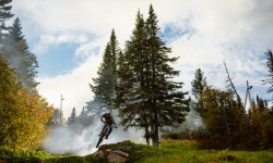
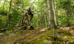
Popular Beaupré Mountain Biking Trails
• 5 ★ 0.0 • 2,523 ft • 15 ft • • skixc
Less popular blue difficulty machine groomed. This nordic ski primary trail. Winter use: Classic / Skating snow grooming.
Beaupré Mountain Bike Routes
★ 4.0 • 11 miles • 856 ft • 4 • Loop •
Parcours débutant/intermédiaire empruntant en grande majorité des sentiers singletracks. Possibilité...
17 miles • 1,221 ft • 11 • Loop •
That is one of the finest way to ride your average mountain bike accros the legendary MSA trail system....
6 miles • 277 ft • 4 • Point to Point •
This is a very nice way to experience Mont-Sainte-Anne from the summit! Warm-up in before hitting the...
9 miles • 1,289 ft • 4 • Loop •
A loop that takes you all the way to rang Saint-Julien featuring La Bouttaboutte, and . A great mix of...
23 miles • 2,191 ft • 12 • Point to Point •
If you have only one day to discover MSA and if you have the legs... You'll strart from the top, but...
7 miles • 527 ft • 2 • Loop •
Starting from the top of the mountain, this short route is a good way to discover the intermediate trails,...
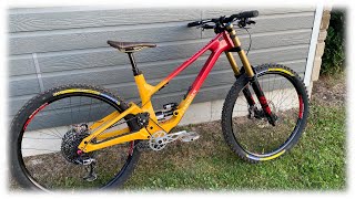
Photos of Beaupré Mountain Bike
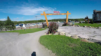
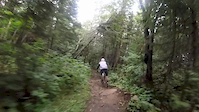
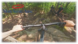
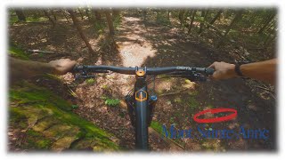
Videos of Beaupré Mountain Bike

trail: 1837 (La Bête)
0:00 |
112 |
Apr 7, 2020
trail: 1837 (La Bête)
2:35 |
164 |
Sep 20, 2018
trail: 1837 Bête
0:47 |
106 |
Sep 10, 2018
youtuber
![45 minutes de DH avec Émile + le crash de...]()

44:05 |
61 |
Jan 26, 2026
youtuber
![La Machine de Freeride Ultime]()
20:29 |
46 |
Oct 6, 2025
youtuber
![On Ride Toute le Slow Tech Double Noir du MSA...]()

41:46 |
40 |
Sep 15, 2025
youtuber
![On test le YT Capra en DH]()
12:38 |
51 |
Jan 20, 2025
youtuber
![DH en trail bike au MSA]()
18:04 |
82 |
Jan 13, 2025
Recent Trail Reports
| status | trail | date | condition | info | user |
|---|---|---|---|---|---|
| Ancienne Vietnam Up | Dec 7, 2025 @ 3:31am (America/Toronto) Dec 7, 2025 | Freeze/thaw Cycle | kyleluvsdh | ||
| Ancienne Vietnam | Dec 7, 2025 @ 3:31am (America/Toronto) Dec 7, 2025 | Freeze/thaw Cycle | kyleluvsdh | ||
| 1837 to WCDH | Dec 7, 2025 @ 3:31am (America/Toronto) Dec 7, 2025 | Freeze/thaw Cycle | kyleluvsdh | ||
| 1837 Bête | Dec 7, 2025 @ 3:31am (America/Toronto) Dec 7, 2025 | Freeze/thaw Cycle | kyleluvsdh | ||
| 1837 (La Bête) | Dec 7, 2025 @ 3:31am (America/Toronto) Dec 7, 2025 | Freeze/thaw Cycle | kyleluvsdh | ||
| 1837 (La Belle) | Dec 7, 2025 @ 3:31am (America/Toronto) Dec 7, 2025 | Freeze/thaw Cycle | kyleluvsdh |
Activity Feed
| username | action | type | title | date |
|---|---|---|---|---|
| seblamenace | wishlist | route | activity #95613191 | May 26, 2026 @ 9:44pm May 26, 2026 |
| atrokz | ridden | trail | activity #94023545 | May 4, 2026 @ 7:30am May 4, 2026 |
| trailforks | add | event | activity #93498718 | Apr 26, 2026 @ 9:45pm Apr 26, 2026 |
| PupPuck | wishlist | region | activity #93469463 | Apr 26, 2026 @ 12:40pm Apr 26, 2026 |
| Sylvinado | add | report | activity #90452273 | Mar 12, 2026 @ 12:18pm Mar 12, 2026 |
Recent Comments
| username | type | title | comment | date |
|---|---|---|---|---|
| trail | Butt puckering, every single time! (in a good... | Mar 5, 2022 @ 7:32pm Mar 5, 2022 | ||
| trail | Cette connexion est géniale car vous pouvez... | Feb 27, 2021 @ 11:13am Feb 27, 2021 |
Local Badges
-

Top 10 Trails0 awarded -

Big Ride 30k3,965 awarded -

Epic Ride 50k839 awarded -

10 Expert Trails131 awarded -

Descent 100k Badge36 awarded -

Completionist0 awarded
Bike & Skill Parks
| name | type | city | rating |
|---|---|---|---|
| Mont-Sainte-Anne DH Park | bike park | Beaupré | |
| Pump Track & Skate Park École Secondaire Mont-Sainte-Anne | skill park | Beaupré |
Upcoming Local Events
Activity Type Stats
| activitytype | trails | distance | descent | descent distance | total vertical | rating | global rank | state rank | photos | reports | routes | ridelogs |
|---|---|---|---|---|---|---|---|---|---|---|---|---|
| Mountain Bike | 132 | 125 miles | 37,260 ft | 70 miles | 2,178 ft | #1,370 | #17 | 1,121 | 2,578 | 44 | 43,615 | |
| E-Bike | 185 | 163 miles | 80,636 ft | 104 miles | 2,178 ft | 7 | 2,271 | 6 | 1,498 | |||
| Hike | 59 | 81 miles | 12,723 ft | 31 miles | 2,431 ft | #2,585 | #16 | 1 | 2,435 | 1 | 3,377 | |
| Trail Running | 59 | 81 miles | 12,723 ft | 31 miles | 2,431 ft | #2,137 | #11 | 4 | 2,433 | 2 | 3,279 | |
| Snowshoe | 2 | 3,176 ft | 180 ft | 20 ft | #406 | #12 | 60 | 193 | ||||
| Downhill Ski | 81 | 50 miles | 51,588 ft | 50 miles | 2,037 ft | #137 | #2 | 31 | 3,351 | |||
| Backcountry Ski | 18 | 15 miles | 5,758 ft | 5 miles | 2,028 ft | #218 | #5 | 23 | 2,371 | |||
| Nordic Ski | 23 | 52 miles | 4,557 ft | 20 miles | 2,011 ft | #101 | #2 | 1 | 62 | 6,911 |
Frequently Asked Questions About Beaupré
▼
What are the best places to ride in Beaupré?
Beaupré has 4 areas to explore for mountain biking. The top rated areas are:
▼
What are the highest rated mountain biking trails in Beaupré?
The highest rated mountain biking trails in Beaupré are:
- 1837 (La Bête) (4.4/5)
- 1837 (La Belle) (4.4/5)
- 1837 Bête (4.2/5)
- Ancienne Vietnam (0/5)
- Ski de Fond (0/5)
▼
What is the best time of the year to ride in Beaupré?
Based on ride log data, the most popular months to ride in Beaupré are:
- July (1,192 activities)
- August (948 activities)
- September (740 activities)
▼
Where can I park to ride in Beaupré?
Check the Beaupré trail map for trailhead and parking information. Community members regularly update access and parking details for trails in the area.
Activities
Trails
- By brenthillier
 NSMBA TRAILFORKS & contributors
 - Admins: QVDM, quebecsingletrack
- #7345 - 8,838 views
- beaupré activity log | embed map of Beaupré mountain bike trails | beaupré mountain biking points of interest
Downloading of trail gps tracks in kml & gpx formats is enabled for Beaupré.
You must login to download files.