close
-
Layers w
- Weather Layers
- Pro
- Pro
- Pro
- Pro
- Pro
- Pro
- More Layers
- Pro
- Pro
- Pro
- Pro
-
Upgrade to

3D
Trail Conditions
- Unknown
- Snow Groomed
- Snow Packed
- Snow Covered
- Snow Cover Partial
- Freeze/thaw Cycle
- Icy
- Prevalent Mud
- Wet
- Variable
- Ideal
- Dry
- Very Dry
Trail Flow (Ridden Direction)
Trailforks scans users ridelogs to determine the most popular direction each trail is ridden. A good flowing trail network will have most trails flowing in a single direction according to their intension.
The colour categories are based on what percentage of riders are riding a trail in its intended direction.
The colour categories are based on what percentage of riders are riding a trail in its intended direction.
- > 96%
- > 90%
- > 80%
- > 70%
- > 50%
- < 50%
- bi-directional trail
- no data
Trail Last Ridden
Trailforks scans ridelogs to determine the last time a trail was ridden.
- < 2 days
- < 1 week
- < 2 weeks
- < 1 month
- < 6 months
- > 6 months
Trail Ridden Direction
The intended direction a trail should be ridden.
- Downhill Only
- Downhill Primary
- Both Directions
- Uphill Primary
- Uphill Only
- One Direction
Contribute Details
Colors indicate trail is missing specified detail.
- Description
- Photos
- Description & Photos
- Videos
Trail Popularity ?
Trailforks scans ridelogs to determine which trails are ridden the most in the last 9 months.
Trails are compared with nearby trails in the same city region with a possible 25 colour shades.
Think of this as a heatmap, more rides = more kinetic energy = warmer colors.
- most popular
- popular
- less popular
- not popular
ATV/ORV/OHV Filter
Max Vehicle Width
inches
US Cell Coverage
Legend

Radar Time
Activity Recordings
Trailforks uses anonymized public activity data.
?
Activity Recordings
Trailforks uses anonymized public activity data.
?
Personal Heatmap
▶
Activity Types
all
/
none
▶
Options
2
Date range
month
–
Winter Trails
Warning
A routing network for winter maps does not exist. Selecting trails using the winter trails layer has been disabled.
Missing Trails
Most Popular
Least Popular
Trails are colored based on popularity. The more popular a trail is, the more red. Less popular trails trend towards green.
Jump Magnitude Heatmap
Heatmap of where riders jump on trails. Zoom in to see individual jumps, click circles to view jump details.
BC Backroad Status
![map legend]()
Service Road Atlas is a free to use, community-driven service for viewing and creating reports on the numerous back-country service roads around B.C. and Alberta.

Slope Aspect
Direction the slope faces
Trails Deemphasized
Trails are shown in grey.
Only show trails with no bike usage.
Suggested Layers
Based on selected activity type
Save the current map location and zoom level as your default home location whenever this page is loaded.
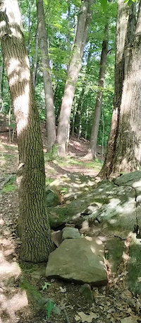
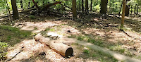
SaveBedford Reservation is a part of the Cleveland Metroparks, and has about 11 miles of easy mountain bike trails.
Primary Trail Type: Cross-Country
Land Status: City Managed
 google parking directions
 Access Info:
There is parking at the Egbert Picnic Area on Gorge Parkway.
Links
Activities Click to view
- Mountain Bike
21 trails
- Horse
6 trails
- Hike
27 trails
- Trail Running
27 trails
Region Details
- 2
- 6
- 9
Region Status
Open as of Sep 5, 2025Stats
- Avg Trail Rating
- Global Ranking
- #9,699
- State Ranking
- #3,824
- Trails (view details)
- 21
- Trails Mountain Bike
- 21
- Trails E-Bike
- 3
- Trails Horse
- 6
- Trails Hike
- 27
- Trails Trail Running
- 27
- Total Distance
- 26 miles
- Total Descent
- 2,013 ft
- Total Vertical
- 352 ft
- Highest Trailhead
- 977 ft
- Reports
- 169
- Photos
- 4
- Ridden Counter
- 3,443
Popular Bedford Reservation Mountain Biking Trails
• 90 ★ 3.0 • 4,304 ft • 42 ft • 278 •
Popular blue difficulty singletrack. This mountain bike primary trail. On average it takes 3 minutes to complete this trail.
• 100 ★ 3.0 • 2 miles • 79 ft • 272 •
Popular blue difficulty singletrack. This mountain bike primary trail. On average it takes 7 minutes to complete this trail.
• 80 ★ 3.0 • 1 mile • 105 ft • 269 •
Popular blue difficulty singletrack. This mountain bike primary trail. On average it takes 8 minutes to complete this trail.
• 60 ★ 4.0 • 4,646 ft • 76 ft • 264 •
Moderately popular blue difficulty singletrack. This mountain bike primary trail. On average it takes 7 minutes to complete this trail.
• 65 ★ 3.0 • 1,699 ft • 29 ft • 259 •
Moderately popular blue difficulty singletrack. This mountain bike primary trail. On average it takes 2 minutes to complete this trail.
• 70 ★ 2.0 • 4,459 ft • 45 ft • 252 •
Popular green difficulty singletrack. This mountain bike primary trail. On average it takes 5 minutes to complete this trail.
• 75 ★ 0.0 • 1,988 ft • 30 ft • 250 •
Popular blue difficulty singletrack. This mountain bike primary trail. On average it takes 2 minutes to complete this trail.
• 45 ★ 3.0 • 2 miles • 119 ft • 241 •
Moderately popular blue difficulty singletrack. This mountain bike primary trail. On average it takes 9 minutes to complete this trail.
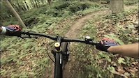
Videos of Bedford Reservation Mountain Bike
trail: Touch Stone North
0:06 |
54 |
Jun 21, 2023
trail: Wight Oaks Loop - South
0:05 |
40 |
Jun 21, 2023
trail: Touch Stone South
0:09 |
103 |
Jun 15, 2023
Recent Trail Reports
| status | trail | date | condition | info | user |
|---|---|---|---|---|---|
| Egbert Picnic Area and Trailhead Connector | Sep 5, 2025 @ 3:41pm Sep 5, 2025 | Ideal | suthaar | ||
| Wight Oaks Loop - South | Aug 17, 2025 @ 7:52am Aug 17, 2025 | Ideal | jnaidorf | ||
| Friendship Trail | Aug 17, 2025 @ 7:52am Aug 17, 2025 | Ideal | jnaidorf | ||
| Eddie's Wildlife Pass | Aug 17, 2025 @ 7:52am Aug 17, 2025 | Ideal | jnaidorf | ||
| Touch Stone North | Nov 17, 2024 @ 1:05pm Nov 17, 2024 | Ideal | clip78 | ||
| Parallel Universe | Nov 17, 2024 @ 1:05pm Nov 17, 2024 | Ideal | clip78 | ||
| Volunteer Spirit Trail | Nov 17, 2024 @ 1:05pm Nov 17, 2024 | Ideal | clip78 | ||
| Moore Trails! | Nov 17, 2024 @ 1:05pm Nov 17, 2024 | Ideal | clip78 | ||
| Wight Oaks Loop - North | Nov 17, 2024 @ 1:05pm Nov 17, 2024 | Ideal | clip78 | ||
| Karl's Corner | Nov 17, 2024 @ 1:05pm Nov 17, 2024 | Ideal | clip78 |
Activity Feed
| username | action | type | title | date |
|---|---|---|---|---|
| lmcmahon60393 | ridden | trail | activity #91616006 and 2 more | Mar 30, 2026 @ 4:25pm Mar 30, 2026 |
| somecallmetim | add | photo | activity #87378970 | Jan 17, 2026 @ 4:26pm Jan 17, 2026 |
| somecallmetim | ridden | trail | activity #87376804 and 5 more | Jan 17, 2026 @ 3:53pm Jan 17, 2026 |
| dustmuffins | ridden | trail | activity #83637772 and 8 more | Nov 5, 2025 @ 1:46pm Nov 5, 2025 |
| Egotist9O3Y4V | wishlist | region | activity #80822553 | Sep 21, 2025 @ 7:42am Sep 21, 2025 |
Recent Comments
| username | type | title | comment | date |
|---|---|---|---|---|
| trail | Trail direction is backwards. This is a one... | Jun 2, 2025 @ 7:40pm Jun 2, 2025 | ||
| trail | Direction on Trailforks is wrong. This is a... | Jun 2, 2025 @ 7:39pm Jun 2, 2025 | ||
| report | Very dry despite slight rain today | Oct 6, 2019 @ 6:27pm Oct 6, 2019 | ||
| report | Dry | Jul 5, 2017 @ 4:01pm Jul 5, 2017 | ||
| report | Dry and good to go. | Jul 5, 2017 @ 4:00pm Jul 5, 2017 |
Nearby Areas
| name | distance | ||||
|---|---|---|---|---|---|
| Cuyahoga Valley National Park | 24 | 2 | 5.9 km | ||
| Ohio & Erie Canal Reservation | 2 | 2 | 6.8 km | ||
| West Creek Reservation | 8 | 7.4 km | |||
| South Chagrin Reservation | 7.4 km | ||||
| East Rim Trails | 5 | 1 | 8.2 km |
Local Badges
-

Completionist0 awarded
Activity Type Stats
| activitytype | trails | distance | descent | descent distance | total vertical | rating | global rank | state rank | photos | reports | routes | ridelogs |
|---|---|---|---|---|---|---|---|---|---|---|---|---|
| Mountain Bike | 21 | 14 miles | 1,257 ft | 6 miles | 154 ft | #9,699 | #3,824 | 4 | 169 | 2,861 | ||
| E-Bike | 3 | 1 mile | 92 ft | 2,972 ft | 82 ft | 154 | 55 | |||||
| Horse | 6 | 10 miles | 755 ft | 5 miles | 299 ft | #2,464 | #1,367 | 17 | ||||
| Hike | 27 | 26 miles | 2,014 ft | 11 miles | 351 ft | #7,468 | #2,742 | 169 | 106 | |||
| Trail Running | 27 | 26 miles | 2,014 ft | 11 miles | 351 ft | #6,920 | #2,260 | 169 | 65 |
Frequently Asked Questions About Bedford Reservation
▼
What are the highest rated mountain biking trails in Bedford Reservation?
The highest rated mountain biking trails in Bedford Reservation are:
- Touch Stone North (4/5)
- Mars Quarry (4/5)
- Wight Oaks Loop - South (3.8/5)
- Wight Oaks Loop - North (3.8/5)
- Friendship Trail (3.8/5)
▼
What is the best time of the year to ride in Bedford Reservation?
Based on ride log data, the most popular months to ride in Bedford Reservation are:
- August (45 activities)
- July (37 activities)
- September (30 activities)
▼
Where can I park to ride in Bedford Reservation?
There are 7 parking locations listed in Bedford Reservation. The most popular parking spots are:
- Parking
- Parking
- Bridal Veil Falls Parking Lot
- Touch Stone Trail Head Parking
- Egbert Picnic Area and Trailhead
▼
What is the longest trail in Bedford Reservation?
The longest trail in Bedford Reservation is Parallel Universe at 1.6 miles. View all trails sorted by distance.
Activities
- By swampboy62 & contributors
- Admins: CAMBA, CAMBA
- #6054 - 8,838 views
- bedford reservation activity log | embed map of Bedford Reservation mountain bike trails | bedford reservation mountain biking points of interest
Downloading of trail gps tracks in kml & gpx formats is enabled for Bedford Reservation.
You must login to download files.