close
-
Layers w
- Weather Layers
- Pro
- Pro
- Pro
- Pro
- Pro
- Pro
- More Layers
- Pro
- Pro
- Pro
- Pro
-
Upgrade to

3D
Trail Conditions
- Unknown
- Snow Groomed
- Snow Packed
- Snow Covered
- Snow Cover Partial
- Freeze/thaw Cycle
- Icy
- Prevalent Mud
- Wet
- Variable
- Ideal
- Dry
- Very Dry
Trail Flow (Ridden Direction)
Trailforks scans users ridelogs to determine the most popular direction each trail is ridden. A good flowing trail network will have most trails flowing in a single direction according to their intension.
The colour categories are based on what percentage of riders are riding a trail in its intended direction.
The colour categories are based on what percentage of riders are riding a trail in its intended direction.
- > 96%
- > 90%
- > 80%
- > 70%
- > 50%
- < 50%
- bi-directional trail
- no data
Trail Last Ridden
Trailforks scans ridelogs to determine the last time a trail was ridden.
- < 2 days
- < 1 week
- < 2 weeks
- < 1 month
- < 6 months
- > 6 months
Trail Ridden Direction
The intended direction a trail should be ridden.
- Downhill Only
- Downhill Primary
- Both Directions
- Uphill Primary
- Uphill Only
- One Direction
Contribute Details
Colors indicate trail is missing specified detail.
- Description
- Photos
- Description & Photos
- Videos
Trail Popularity ?
Trailforks scans ridelogs to determine which trails are ridden the most in the last 9 months.
Trails are compared with nearby trails in the same city region with a possible 25 colour shades.
Think of this as a heatmap, more rides = more kinetic energy = warmer colors.
- most popular
- popular
- less popular
- not popular
ATV/ORV/OHV Filter
Max Vehicle Width
inches
US Cell Coverage
Legend

Radar Time
Activity Recordings
Trailforks uses anonymized public activity data.
?
Activity Recordings
Trailforks uses anonymized public activity data.
?
Personal Heatmap
▶
Activity Types
all
/
none
▶
Options
2
Date range
month
–
Winter Trails
Warning
A routing network for winter maps does not exist. Selecting trails using the winter trails layer has been disabled.
Missing Trails
Most Popular
Least Popular
Trails are colored based on popularity. The more popular a trail is, the more red. Less popular trails trend towards green.
Jump Magnitude Heatmap
Heatmap of where riders jump on trails. Zoom in to see individual jumps, click circles to view jump details.
BC Backroad Status
![map legend]()
Service Road Atlas is a free to use, community-driven service for viewing and creating reports on the numerous back-country service roads around B.C. and Alberta.

Slope Aspect
Direction the slope faces
Trails Deemphasized
Trails are shown in grey.
Only show trails with no bike usage.
Suggested Layers
Based on selected activity type
Save the current map location and zoom level as your default home location whenever this page is loaded.
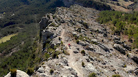
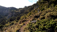
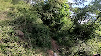
SaveThe city of Berga and the municipality of Berguedà is home to an insane amount of bikeable trails. From 2500 meters altitude all the way down to 500 meters altitude gives home to year round biking. Road biking and XC-biking are popular with the local crowd but here on Trailforks the focus is on alpine enduro trails. 99% of the enduro riding here is done on old work trails between villages, from the abandoned carbon mines or on alpine trails. If you're used to riding bikeparks you'll find different challenges here.
Some good to know points:
All of the main enduro trails are possible to shuttle on good asphalt roads up to high passes.
The north sides are more humid and less rocky while the south side generally gives more technical terrain.
The high areas have snow in winter so be careful with choosing your trails in wintertime.
eBikes Allowed:
Yes
AKA: Berguedà
This region uses the Uk/Euro style trail grading system.
Activities Click to view
- Mountain Bike
623 trails
- E-Bike
579 trails
- Adaptive Bike
14 trails
- Horse
14 trails
- Hike
620 trails
- Trail Running
616 trails
Region Details
- 112
- 122
- 221
- 108
- 59
Region Status
Caution as of Jun 14, 2026Local Trail Association
Stats
- Avg Trail Rating
- Trails (view details)
- 630
- Trails Mountain Bike
- 623
- Trails E-Bike
- 579
- Trails Gravel Bike
- 1
- Trails Adaptive Bike
- 14
- Trails Horse
- 14
- Trails Hike
- 620
- Trails Trail Running
- 616
- Trails Dirtbike/Moto
- 1
- Trails ATV/ORV/OHV
- 1
- Total Distance
- 603 miles
- Total Descent
- 253,348 ft
- Total Vertical
- 7,163 ft
- Highest Trailhead
- 8,247 ft
- Reports
- 3,663
- Photos
- 624
- Ridden Counter
- 24,560
Sub Regions
-
4 Riders Bike Park
- 2
- 1
- 2
- 1
-
El Berguedà
- 105
- 202
- 101
- 58
-
Lluçanès Enduro
- 10
- 6
- 2
Popular Berga Mountain Biking Trails
• 100 ★ 5.0 • 1 mile • 20 ft • 299 •
Pista fàcil amb molts peraltes enormes i algunes mesetes no massa grans.
• 60 ★ 4.0 • 3,143 ft • 15 ft • 265 •
Highly rated moderately popular red difficulty machine groomed. This multi-use trail can be used downhill only. It features berm, bridge, drop and gap jump. Trail visibility is always easy to follow. On average it takes 9 minutes to complete this trail.
• 80 ★ 4.8 • 3,596 ft • 7 ft • 237 •
Popular red difficulty machine groomed. This multi-use trail can be used downhill only. It features berm, drop, jump and gap jump. Trail visibility is always easy to follow. On average it takes 6 minutes to complete this trail.
• 40 ★ 4.5 • 2,195 ft • 0 ft • 220 •
Moderately popular black difficulty singletrack. This multi-use trail can be used downhill only. It features berm, drop, jump, gap jump and rock garden. Trail visibility is always easy to follow. On average it takes 10 minutes to complete this trail.
• 20 ★ 2.0 • 249 ft • 0 ft • 211 •
Less popular green difficulty singletrack. This mountain bike primary trail and has a easy overall physical rating with a 0 ft blue climb. Trail visibility is always easy to follow. On average it takes 1 minutes to complete this trail.
• 95 ★ 4.6 • 4,911 ft • 9 ft • 176 •
EN: Another excellent trail for the area. Last bit: From the bridge the trail goes steep down (and way more difficult) down to the main road where you can have a car parked by and shuttle up. If you're heading up to Vallcebre you skip...
• 85 ★ 4.5 • 4,036 ft • 16 ft • 155 •
EN: Superb open rocky landscapes with a lot of small jumps. A must! ES: Parte genial con mini-saltos y mucho espacio.
Berga Mountain Bike Routes
Visit Capolat Featured
★ 4.7 • 14 miles • 2,912 ft • 10 • Loop •
The perfect introduction to the dryer southern part of our riding paradise. Here the rock type is...
Catllaràs Dreams Featured
★ 4.2 • 13 miles • 3,534 ft • 5 • Loop •
EN: Possible one of the better forest enduro routes in Spain. Incredible +1100 vertical meters of downhill...
Visit Vilada Featured
★ 5.0 • 16 miles • 4,780 ft • 8 • Loop •
EN: Long uphill on gravel road with nice views and a chance to stop in the nice hut midway for a refill of...
★ 5.0 • 5 miles • 1,258 ft • 3 • Loop •
EN: Great combination of the trails of and TT 78. Expect quite a hard uphill... ES: Combinación genial de...
★ 4.0 • 33 miles • 8,859 ft • 16 • Loop •
Ruta larga con dos buenos descendos de montana. Buenas vistas de la zona del Pedraforca. Empuja bici de...
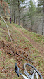
Photos of Berga Mountain Bike
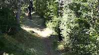
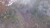
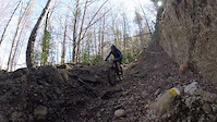
Videos of Berga Mountain Bike
featured
![Trails with a view]()
trail: Serra de Corbera
0:10 |
163 |
Oct 2, 2018
trail: Cingles de Vall-Llobrega
0:17 |
365 |
Sep 28, 2021
trail: Cucut
3:33 |
67 |
Jun 11, 2021

trail: Cal Paulo
3:10 |
9 |
May 25, 2021
trail: The Two Peaks part 1
0:08 |
51 |
Apr 10, 2021
trail: Got-got
0:40 |
69 |
Apr 9, 2021
trail: The Mule Killer
0:48 |
149 |
Mar 26, 2021
trail: The Wolf part 1
0:08 |
|
Feb 14, 2021
Current Trail Warnings
| status | trail | date | condition | user | info |
|---|---|---|---|---|---|
| Banyadors Direct | Jun 8, 2026 @ 10:41am (Europe/Madrid) Jun 8, 2026 | Ideal | delabozzo | E-Bike Molts arbres caiguts al tram llarg... | |
| Sobrepuny Vertical | Jun 6, 2026 @ 9:35am (Europe/Madrid) Jun 6, 2026 | Variable | kardi13 TFSPAIN | En general molt malament degut a les... | |
| The Panter 3 | Jun 6, 2026 @ 9:18am (Europe/Andorra) Jun 6, 2026 | Variable | eldecalblau | Està fet un desastre. Moolts arbres i... |
Recent Trail Reports
| status | trail | date | condition | info | user |
|---|---|---|---|---|---|
| Planàs part 2 | Jun 14, 2026 @ 10:36pm (Europe/Madrid) Jun 14, 2026 | Dry | delabozzo | ||
| Planàs part 1 | Jun 14, 2026 @ 10:36pm (Europe/Madrid) Jun 14, 2026 | Dry | delabozzo | ||
| Joc de Pilota | Jun 14, 2026 @ 10:34pm (Europe/Madrid) Jun 14, 2026 | Ideal | delabozzo | ||
| The Panter part 1 | Jun 14, 2026 @ 10:32pm (Europe/Madrid) Jun 14, 2026 | Ideal | delabozzo | ||
| El Toixó | Jun 8, 2026 @ 10:37am (Europe/Madrid) Jun 8, 2026 | Wet | delabozzo | ||
| Gall Fer | Jun 8, 2026 @ 10:34am (Europe/Madrid) Jun 8, 2026 | Wet | delabozzo | ||
| Vilada Express Upper | Jun 6, 2026 @ 9:35am (Europe/Madrid) Jun 6, 2026 | Variable | kardi13 TFSPAIN | ||
| Return to Sant Julia | Jun 6, 2026 @ 9:35am (Europe/Madrid) Jun 6, 2026 | Variable | kardi13 TFSPAIN | ||
| Fulleracs | Jun 6, 2026 @ 9:35am (Europe/Madrid) Jun 6, 2026 | Variable | kardi13 TFSPAIN | ||
| La Nou to Catllaràs | Jun 6, 2026 @ 9:35am (Europe/Madrid) Jun 6, 2026 | Variable | kardi13 TFSPAIN |
Activity Feed
| username | action | type | title | date |
|---|---|---|---|---|
| edgarcerda | wishlist | route | activity #97035365 | Jun 15, 2026 @ 5:52am Jun 15, 2026 |
| delabozzo | add | report | activity #97000975 and 3 more | Jun 14, 2026 @ 1:33pm Jun 14, 2026 |
| MichelRush | comment | route | activity #96904689 | Jun 13, 2026 @ 12:17pm Jun 13, 2026 |
| MichelRush | ridden | route | activity #96853243 | Jun 13, 2026 @ 1:07am Jun 13, 2026 |
| MichelRush | wishlist | region | activity #96829197 | Jun 12, 2026 @ 2:47pm Jun 12, 2026 |
Recent Comments
| username | type | title | comment | date |
|---|---|---|---|---|
| report | Trail net i repassat per Berga Enduro | Jun 9, 2026 @ 11:09pm Jun 9, 2026 | ||
| report | Tot net i repasat per Berga Enduro | Jun 9, 2026 @ 11:07pm Jun 9, 2026 | ||
| trail | Si vas a hacer un loop de enduro puede... | Jun 1, 2026 @ 6:03am Jun 1, 2026 | ||
| trail | No espereu una baixada "clàssica", és més... | May 31, 2026 @ 8:30am May 31, 2026 | ||
| report | Se mantiene en forma ..un árbol caído que se... | Apr 24, 2026 @ 11:51am Apr 24, 2026 |
Local Badges
-

El Minero2 awarded -

Completionist0 awarded -

Top 10 Trails1 awarded -
Completionist0 awarded -
Completionist0 awarded -

Epic Ride 50k1,456 awarded
Bike & Skill Parks
| name | type | city | rating |
|---|---|---|---|
| 4 Riders Bike Park | bike park | Berga | |
| Mini DH | skill park | Berga | |
| MC Baix Berguedà motocross | skill park | Berga |
Activity Type Stats
| activitytype | trails | distance | descent | descent distance | total vertical | rating | global rank | state rank | photos | reports | routes | ridelogs |
|---|---|---|---|---|---|---|---|---|---|---|---|---|
| Mountain Bike | 623 | 592 miles | 246,257 ft | 370 miles | 7,162 ft | #163 | #20 | 616 | 3,662 | 17 | 12,616 | |
| E-Bike | 579 | 556 miles | 230,289 ft | 348 miles | 6,916 ft | #32 | #27 | 8 | 3,593 | 12 | 3,010 | |
| Gravel Bike | 1 | 2,018 ft | 121 ft | #637 | #5 | 9 | 182 | |||||
| Adaptive Bike | 14 | #97 | #85 | 3 | ||||||||
| Horse | 14 | 13 miles | 4,429 ft | 7 miles | 4,127 ft | #302 | #23 | 109 | ||||
| Hike | 620 | 598 miles | 250,157 ft | 372 miles | 7,162 ft | #88 | #25 | 3,609 | 2 | 1,877 | ||
| Trail Running | 616 | 596 miles | 247,936 ft | 371 miles | 7,162 ft | #65 | #25 | 3,605 | 2 | 1,494 | ||
| Dirtbike/Moto | 1 | 106 | 3 | |||||||||
| ATV/ORV/OHV | 1 | 104 |
Frequently Asked Questions About Berga
▼
What are the best places to ride in Berga?
Berga has 11 areas to explore for mountain biking. The top rated areas are:
▼
What are the highest rated mountain biking trails in Berga?
The highest rated mountain biking trails in Berga are:
- Commencal (4.5/5)
- Tossal Llissol (4.5/5)
- Solei Albiol (4.5/5)
- Coll Pan (4.5/5)
- El Gaudi (4.4/5)
▼
What is the best time of the year to ride in Berga?
Based on ride log data, the most popular months to ride in Berga are:
- October (73 activities)
- May (70 activities)
- June (64 activities)
▼
Where can I park to ride in Berga?
There are 28 parking locations listed in Berga. The most popular parking spots are: View all parking and trailhead locations on the map to plan your visit.
Activities
Trails
- By carballada & contributors
- Admins: snaker4, kai-bcn, henrikenduro, Galis, parlindholm, kardi13
- #18339 - 26,644 views
- berga activity log | embed map of Berga mountain bike trails | berga mountain biking points of interest
Downloading of trail gps tracks in kml & gpx formats is enabled for Berga.
You must login to download files.