close
-
Layers w
- Weather Layers
- Pro
- Pro
- Pro
- Pro
- Pro
- Pro
- More Layers
- Pro
- Pro
- Pro
- Pro
-
Upgrade to

3D
Trail Conditions
- Unknown
- Snow Groomed
- Snow Packed
- Snow Covered
- Snow Cover Partial
- Freeze/thaw Cycle
- Icy
- Prevalent Mud
- Wet
- Variable
- Ideal
- Dry
- Very Dry
Trail Flow (Ridden Direction)
Trailforks scans users ridelogs to determine the most popular direction each trail is ridden. A good flowing trail network will have most trails flowing in a single direction according to their intension.
The colour categories are based on what percentage of riders are riding a trail in its intended direction.
The colour categories are based on what percentage of riders are riding a trail in its intended direction.
- > 96%
- > 90%
- > 80%
- > 70%
- > 50%
- < 50%
- bi-directional trail
- no data
Trail Last Ridden
Trailforks scans ridelogs to determine the last time a trail was ridden.
- < 2 days
- < 1 week
- < 2 weeks
- < 1 month
- < 6 months
- > 6 months
Trail Ridden Direction
The intended direction a trail should be ridden.
- Downhill Only
- Downhill Primary
- Both Directions
- Uphill Primary
- Uphill Only
- One Direction
Contribute Details
Colors indicate trail is missing specified detail.
- Description
- Photos
- Description & Photos
- Videos
Trail Popularity ?
Trailforks scans ridelogs to determine which trails are ridden the most in the last 9 months.
Trails are compared with nearby trails in the same city region with a possible 25 colour shades.
Think of this as a heatmap, more rides = more kinetic energy = warmer colors.
- most popular
- popular
- less popular
- not popular
ATV/ORV/OHV Filter
Max Vehicle Width
inches
US Cell Coverage
Legend

Radar Time
Activity Recordings
Trailforks uses anonymized public activity data.
?
Activity Recordings
Trailforks uses anonymized public activity data.
?
Personal Heatmap
▶
Activity Types
all
/
none
▶
Options
2
Date range
month
–
Winter Trails
Warning
A routing network for winter maps does not exist. Selecting trails using the winter trails layer has been disabled.
Missing Trails
Most Popular
Least Popular
Trails are colored based on popularity. The more popular a trail is, the more red. Less popular trails trend towards green.
Jump Magnitude Heatmap
Heatmap of where riders jump on trails. Zoom in to see individual jumps, click circles to view jump details.
BC Backroad Status
![map legend]()
Service Road Atlas is a free to use, community-driven service for viewing and creating reports on the numerous back-country service roads around B.C. and Alberta.

Slope Aspect
Direction the slope faces
Trails Deemphasized
Trails are shown in grey.
Only show trails with no bike usage.
Suggested Layers
Based on selected activity type
Save the current map location and zoom level as your default home location whenever this page is loaded.
Save
No description for Berkeley County has been added yet!
Login or register to submit one.
Links
Activities Click to view
- Mountain Bike
32 trails
- E-Bike
11 trails
- Horse
2 trails
- Hike
32 trails
- Trail Running
32 trails
- Dirtbike/Moto
11 trails
- ATV/ORV/OHV
11 trails
Region Details
- 1
- 1
- 18
- 12
Stats
- Avg Trail Rating
- Trails (view details)
- 32
- Trails Mountain Bike
- 32
- Trails E-Bike
- 11
- Trails Horse
- 2
- Trails Hike
- 32
- Trails Trail Running
- 32
- Trails Dirtbike/Moto
- 11
- Trails ATV/ORV/OHV
- 11
- Total Distance
- 160 miles
- Total Descent
- 5,167 ft
- Total Vertical
- 112 ft
- Highest Trailhead
- 114 ft
- Reports
- 277
- Photos
- 45
- Ridden Counter
- 865
Sub Regions
Popular Berkeley County Mountain Biking Trails
• 80 ★ 4.0 • 8 miles • 96 ft • 183 •
Popular blue difficulty singletrack. This multi-use trail can be used downhill primary. On average it takes 46 minutes to complete this trail.
• 100 ★ 3.8 • 7 miles • 1,337 ft • 179 •
The runs within the north portion of Wannamaker County Park, accessible from Goose Creek. The 13-mile trail is designed for and open to mountain bicyclists of all experience levels. The trail is also open to hikers, walkers, and...
• 85 ★ 4.5 • 2,585 ft • 8 ft • 174 •
Popular blue difficulty mixed. This multi-use trail can be used both directions. On average it takes 6 minutes to complete this trail.
• 100 ★ 3.8 • 2,815 ft • 84 ft • 142 •
Popular blue difficulty singletrack. This mountain bike primary trail can be used downhill primary. On average it takes 2 minutes to complete this trail.
• 95 ★ 4.0 • 4 miles • 829 ft • 142 •
Popular blue difficulty singletrack. This mountain bike primary trail can be used both directions. On average it takes 40 minutes to complete this trail.
• 35 ★ 3.4 • 992 ft • 27 ft • 140 •
Less popular blue difficulty singletrack. This mountain bike primary trail can be used downhill primary. On average it takes 1 minutes to complete this trail.
• 50 ★ 3.8 • 4,708 ft • 209 ft • 140 •
Moderately popular blue difficulty singletrack. This mountain bike primary trail can be used downhill primary. On average it takes 7 minutes to complete this trail.
• 70 ★ 3.7 • 1 mile • 181 ft • 137 •
Popular blue difficulty singletrack. This mountain bike primary trail can be used both directions. On average it takes 8 minutes to complete this trail.
Berkeley County Mountain Bike Routes
12 miles • 131 ft • 2 • Loop •
You'll hit all 3 single track trails. , to Blue to Orange loop, back to Blue to the trailhead.
9 miles • 134 ft • 0 •
Paved trail and roads with some heaving in the pavement due to roots Beginner trail
1 mile • 18 ft • 0 • Loop • Race •
The Wednesday Wannamaker Worlds XCC Course
Photos of Berkeley County Mountain Bike
Videos of Berkeley County Mountain Bike

7:41 |
129 |
May 26, 2025 , My City
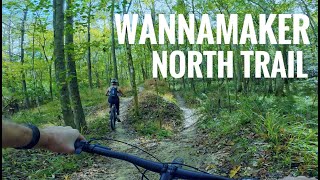
trail: Wannamaker North Trail
4:24 |
2713 |
Nov 12, 2020 , Goose Creek
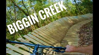
trail: Biggin Creek Loop
3:05 |
1996 |
Oct 29, 2020 , Moncks Corner
Current Trail Warnings
| status | trail | date | condition | user | info |
|---|---|---|---|---|---|
| Wannamaker North Trail Wannamaker County Park | May 24, 2026 @ 10:54am (America/Kentucky/Monticello) May 24, 2026 | Wet | redneckhippiegeek | Trail is closed to dry out |
Recent Trail Reports
National Scenic Trails & Official Routes
-
The Palmetto Trail
- Mountain Bike
- Horse
- Hike
- Trail Running
Activity Feed
| username | action | type | title | date |
|---|---|---|---|---|
| jbrittain | add | photo | activity #96509319 and 4 more | Jun 7, 2026 @ 5:10pm Jun 7, 2026 |
| jbrittain | add | photo | activity #96403388 and 1 more | Jun 6, 2026 @ 1:45pm Jun 6, 2026 |
| jbrittain | wishlist | region | activity #96403190 | Jun 6, 2026 @ 1:43pm Jun 6, 2026 |
| SylvesterStalloam | add | report | activity #95983374 and 5 more | May 31, 2026 @ 3:39pm May 31, 2026 |
| redneckhippiegeek | add | report | activity #95422310 | May 24, 2026 @ 10:07am May 24, 2026 |
Recent Comments
| username | type | title | comment | date |
|---|---|---|---|---|
| trail | Two word review. Sand Sandwich. Need a fat bike. | Oct 19, 2023 @ 7:23pm Oct 19, 2023 | ||
| trail | The Trail crew has been out clearing some of... | Sep 24, 2023 @ 5:54pm Sep 24, 2023 | ||
| trail | love this beautiful dike ride. | Apr 1, 2023 @ 6:33pm Apr 1, 2023 | ||
| trail | Horrible "trail" - either potholed back roads... | Feb 19, 2023 @ 6:48pm Feb 19, 2023 | ||
| trail | Tight single track full of tight turns and... | Jan 7, 2023 @ 5:31am Jan 7, 2023 |
Activity Type Stats
| activitytype | trails | distance | descent | descent distance | total vertical | rating | global rank | state rank | photos | reports | routes | ridelogs |
|---|---|---|---|---|---|---|---|---|---|---|---|---|
| Mountain Bike | 32 | 160 miles | 5,167 ft | 32 miles | 112 ft | 41 | 277 | 3 | 11,381 | |||
| E-Bike | 11 | 35 miles | 249 ft | 5 miles | 33 ft | 197 | 2 | 386 | ||||
| Horse | 2 | 18 miles | 75 ft | 2 miles | 30 ft | 9 | ||||||
| Hike | 32 | 160 miles | 5,167 ft | 32 miles | 112 ft | 4 | 277 | 305 | ||||
| Trail Running | 32 | 160 miles | 5,167 ft | 32 miles | 112 ft | 277 | 81 | |||||
| Dirtbike/Moto | 11 | 35 miles | 249 ft | 5 miles | 33 ft | 9 | 3 | |||||
| ATV/ORV/OHV | 11 | 35 miles | 249 ft | 5 miles | 33 ft | 9 |
Frequently Asked Questions About Berkeley County
▼
What are the best places to ride in Berkeley County?
Berkeley County has 4 areas to explore for mountain biking. The top rated areas are:
▼
What are the highest rated mountain biking trails in Berkeley County?
The highest rated mountain biking trails in Berkeley County are:
- Trailhead Loop (4.1/5)
- Central Loop (4/5)
- East Loop (4/5)
- Alpha Loop (4/5)
- Jericho Horse Trail (4/5)
▼
What is the best time of the year to ride in Berkeley County?
Based on ride log data, the most popular months to ride in Berkeley County are:
- October (103 activities)
- May (90 activities)
- September (88 activities)
▼
What is the longest trail in Berkeley County?
The longest trail in Berkeley County is The Palmetto Trail - Lake Moultrie Passage at 26.6 miles. View all trails sorted by distance.
Activities
Trails
- By WillieJacobsz
 Trailforks SBP SWW & contributors
 - Admins: SORBA, trailtraverser
- #53116 - 929 views
- berkeley county activity log | embed map of Berkeley County mountain bike trails | berkeley county mountain biking points of interest
Downloading of trail gps tracks in kml & gpx formats is enabled for Berkeley County.
You must login to download files.