close
-
Layers w
- Weather Layers
- Pro
- Pro
- Pro
- Pro
- Pro
- Pro
- More Layers
- Pro
- Pro
- Pro
- Pro
-
Upgrade to

3D
Trail Conditions
- Unknown
- Snow Groomed
- Snow Packed
- Snow Covered
- Snow Cover Partial
- Freeze/thaw Cycle
- Icy
- Prevalent Mud
- Wet
- Variable
- Ideal
- Dry
- Very Dry
Trail Flow (Ridden Direction)
Trailforks scans users ridelogs to determine the most popular direction each trail is ridden. A good flowing trail network will have most trails flowing in a single direction according to their intension.
The colour categories are based on what percentage of riders are riding a trail in its intended direction.
The colour categories are based on what percentage of riders are riding a trail in its intended direction.
- > 96%
- > 90%
- > 80%
- > 70%
- > 50%
- < 50%
- bi-directional trail
- no data
Trail Last Ridden
Trailforks scans ridelogs to determine the last time a trail was ridden.
- < 2 days
- < 1 week
- < 2 weeks
- < 1 month
- < 6 months
- > 6 months
Trail Ridden Direction
The intended direction a trail should be ridden.
- Downhill Only
- Downhill Primary
- Both Directions
- Uphill Primary
- Uphill Only
- One Direction
Contribute Details
Colors indicate trail is missing specified detail.
- Description
- Photos
- Description & Photos
- Videos
Trail Popularity ?
Trailforks scans ridelogs to determine which trails are ridden the most in the last 9 months.
Trails are compared with nearby trails in the same city region with a possible 25 colour shades.
Think of this as a heatmap, more rides = more kinetic energy = warmer colors.
- most popular
- popular
- less popular
- not popular
ATV/ORV/OHV Filter
Max Vehicle Width
inches
US Cell Coverage
Legend

Radar Time
Activity Recordings
Trailforks uses anonymized public activity data.
?
Activity Recordings
Trailforks uses anonymized public activity data.
?
Personal Heatmap
▶
Activity Types
all
/
none
▶
Options
2
Date range
month
–
Winter Trails
Warning
A routing network for winter maps does not exist. Selecting trails using the winter trails layer has been disabled.
Missing Trails
Most Popular
Least Popular
Trails are colored based on popularity. The more popular a trail is, the more red. Less popular trails trend towards green.
Jump Magnitude Heatmap
Heatmap of where riders jump on trails. Zoom in to see individual jumps, click circles to view jump details.
BC Backroad Status
![map legend]()
Service Road Atlas is a free to use, community-driven service for viewing and creating reports on the numerous back-country service roads around B.C. and Alberta.

Slope Aspect
Direction the slope faces
Trails Deemphasized
Trails are shown in grey.
Only show trails with no bike usage.
Suggested Layers
Based on selected activity type
Save the current map location and zoom level as your default home location whenever this page is loaded.
SavePopular Trail Networks
view all areas »
No description for Bern Kanton has been added yet!
Login or register to submit one.
This region uses the Uk/Euro style trail grading system.
Region Details
- 193
- 203
- 318
- 189
- 47
- 3
Local Trail Association
Stats
- Avg Trail Rating
- Trails (view details)
- 974
- Trails Mountain Bike
- 958
- Trails E-Bike
- 810
- Trails Gravel Bike
- 1
- Trails Adaptive Bike
- 1
- Trails Winter Fat Bike
- 1
- Trails Horse
- 1
- Trails Hike
- 892
- Trails Trail Running
- 891
- Total Distance
- 904 miles
- Total Descent
- 391,900 ft
- Total Vertical
- 7,657 ft
- Highest Trailhead
- 9,115 ft
- Reports
- 5,934
- Photos
- 1,697
- Ridden Counter
- 54,075
Articles
Video: Manuel Scheidegger Claims World's First Wheelied Everest
Jun 22, 2020 from pinkbike.com
The Swiss rider clams to have climbed 9,029 metres on his rear wheel in Steffisburg
Video: Claudio Caluori Introduces Pump Track BMXers to Alpine Enduro
Oct 15, 2019 from pinkbike.com
Eddy Clerté and Tommy Zula take a ride with Claudio Caluori to prepare for the Pump Track World Finals in Bern
Sub Regions
- Bezirk Bern-Mittelland (154)
- Belp (9)
- Belpberg (8)
- Bern (53)
- Chünizberg (26)
- Denteberg (2)
- Ostermundigeberg (3)
- Bolligen (16)
- Bantiger (7)
- Schwarzchopf (8)
- Frauenkappelen (5)
- Köniz (44)
- Konolfingen (6)
- Churzenberg (6)
- Laupen (3)
- Mattstetten (3)
- Münchenbuchsee (2)
- Neuenegg (4)
- Oberdiessbach (3)
- Falkenfluh (3)
- Rüeggisberg (2)
- Wohlen Bei Bern (5)
- Belp (9)
- Bezirk Biel/Bienne (80)
- Biel/Bienne (71)
- Bözingeberg (20)
- Magglingen (44)
- La Neuveville (1)
- Twann-Tüscherz (8)
- Biel/Bienne (71)
- Bezirk Emmental (29)
- Burgdorf (11)
- Burgdorf (7)
- Krauchthal (1)
- Langnau Im Emmental (17)
- Burgdorf (11)
- Bezirk Frutigen-Niedersimmental (92)
- Adelboden (15)
- Adelboden (15)
- Aeschi bei Spiez (4)
- Därstetten (10)
- Diemtigen (10)
- Frutigen (4)
- Kandersteg (28)
- Krattigen (3)
- Reichenbach im Kandertal (7)
- Spiez (6)
- Wimmis (4)
- Adelboden (15)
- Bezirk Interlaken-Oberhasli (276)
- Beatenberg (7)
- Brienz BE (19)
- Grindelwald (55)
- Guttannen (4)
- Interlaken (39)
- Lauterbrunnen (34)
- Leissigen (2)
- Meiringen (111)
- Haslital (106)
- Oberried Am Brienzersee (1)
- Bezirk Oberaargau (22)
- Aarwangen (2)
- Attiswil (9)
- Langenthal (11)
- Aarwangen (2)
- Bezirk Obersimmental-Saanenland (191)
- Boltigen (3)
- Lenk (67)
- Lenk - St. Stephan (67)
- Oberwil Im Simmental (1)
- Saanen (128)
- Gstaad Saanenland (120)
- St. Stephan (9)
- Boltigen (3)
- Bezirk Seeland (3)
- Gals (1)
- Ins (1)
- Seedorf BE (1)
- Gals (1)
- Bezirk Thun (95)
- Blumenstein (4)
- Horrenbach-Buchen (2)
- Pohlern (6)
- Reutigen (5)
- Sigriswil (26)
- Blueme (15)
- Steffisburg (24)
- Thun (16)
- Wattenwil (13)
- Blumenstein (4)
- Prefecture Jura Bernois (28)
- Moutier (4)
- Nods (7)
- Orvin (6)
- Plateau de Diesse (2)
- Saint-Imier (1)
- Sauge (2)
- Sonvilier (1)
- Valbirse (5)
- Moutier (4)
Popular Bern Kanton Mountain Biking Trails
• 95 ★ 4.8 • 1 mile • 0 ft • 465 •
Verspielter Flowtrail mit hohen Steilwandkurven und vielen Sprüngen.
• 100 ★ 4.9 • 2 miles • 4 ft • 458 •
Highly rated popular blue difficulty family friendly machine groomed. This mountain bike primary trail and has a moderate overall physical rating. It features berm, drop, jump, gap jump and roller coaster. On average it takes 15 minutes to complete this trail.
• 100 ★ 3.6 • 1,555 ft • 0 ft • 333 •
Nice singletrack, flow at the start, and then full of roots, and to finish a steep part like a WC track !
• 95 ★ 4.2 • 2 miles • 4 ft • 312 •
Great views from Bachalpsee and all the way down to Restaurant . Worth stopping for a cold drink or something to eat on the super terrace.
• 95 ★ 4.4 • 1,240 ft • 0 ft • 308 •
Highly rated popular blue difficulty singletrack. This mountain bike primary trail. On average it takes 3 minutes to complete this trail.
• 100 ★ 4.7 • 1 mile • 4 ft • 304 •
Highly rated popular blue difficulty singletrack. This mountain bike primary trail can be used downhill only and has a moderate overall physical rating. It features jump and roller coaster. On average it takes 11 minutes to complete this trail.
• 100 ★ 4.8 • 3,760 ft • 89 ft • 292 •
Fun traverse through forest. Also popular with hikers
Bern Kanton Mountain Bike Routes
Gstaad Bergbahnen Tour Featured
33 miles • 8,246 ft • 12 • Loop •
This mountain railway tour is for mountain bikers seeking a more challenging experience. With the help of...
★ 4.0 • 13 miles • 1,548 ft • 6 •
EN First, however, the tour starts comfortably with the gondola to the Betelberg to the starting point,...
★ 3.5 • 19 miles • 4,009 ft • 8 • Loop •
EN The ascent first leads over an asphalt and later a gravel road with a pleasant climb to Balemad. Here...
★ 5.0 • 9 miles • 2,982 ft • 5 • Loop •
Als alternative kann man ganz bequem mit der Gondel bis Reuti hochfahren, damit spart man die eher steilen...
★ 4.0 • 19 miles • 4,687 ft • 7 • Loop •
This trail is suitable for trail beginners and advanced, but already require an advanced mountain bike...
★ 3.5 • 19 miles • 4,269 ft • 5 • Loop •
The ascent requires a good level of fitness. On asphalt and later on gravel roads, the route leads through...
Photos of Bern Kanton Mountain Bike
Videos of Bern Kanton Mountain Bike

trail: Leitistock
0:49 |
6 |
May 25, 2026
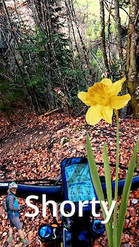
trail: Shorty
0:17 |
4 |
Mar 2, 2026
trail: Abstecher Trail
0:23 |
32 |
Aug 30, 2025

trail: Blackrock
0:50 |
|
Aug 26, 2022
trail: GurtenTrail 2.0
0:08 |
|
Aug 17, 2021
trail: Gurten - Eldorado l
0:08 |
507 |
Jun 4, 2021
trail: Goldiwheel Trail
5:18 |
287 |
Jan 22, 2021

trail: Slalom
0:54 |
1136 |
Nov 1, 2020
Current Trail Warnings
| status | trail | date | condition | user | info |
|---|---|---|---|---|---|
| 2 Brothers Reutigen | Jun 16, 2026 @ 9:54pm (Europe/Zurich) Jun 16, 2026 | Unknown | Jeremi7Tu80g | Weg ist nicht mehr sichtbar | |
| Sergent 2.0 Saint-Imier | May 26, 2026 @ 2:08pm (Europe/Zurich) May 26, 2026 | Dry | armailli | On the top and the bottom part, you can... |
Recent Trail Reports
Activity Feed
| username | action | type | title | date |
|---|---|---|---|---|
| 3HvXrl | wishlist | route | activity #97515581 | Jun 21, 2026 @ 1:22pm 1 day |
| oders3 | wishlist | route | activity #97509404 | Jun 21, 2026 @ 12:17pm 1 day |
| missmission | wishlist | route | activity #97399574 | Jun 20, 2026 @ 8:39am 2 days |
| missmission | wishlist | route | activity #97399355 | Jun 20, 2026 @ 8:37am 2 days |
| nicolais2000 | vote | trail | activity #97397737 and 2 more | Jun 20, 2026 @ 8:20am 2 days |
Recent Comments
| username | type | title | comment | date |
|---|---|---|---|---|
| trail | cleaned - awesome steep trail 👌💯 technical | Jun 1, 2026 @ 11:23pm Jun 1, 2026 | ||
| report | trail ist komplett zugewachsen! kein... | May 23, 2026 @ 8:35am May 23, 2026 | ||
| report | 22.05.26 - alles komplett zugewachsen! trail... | May 23, 2026 @ 8:34am May 23, 2026 | ||
| trail | Watch out for the several metal bindings of... | May 20, 2026 @ 6:08am May 20, 2026 | ||
| trail | Schön zu hören. Kommentare sind für... | Apr 13, 2026 @ 9:14am Apr 13, 2026 |
Local Badges
-

10x Ruine Ägerten2 awarded -

Bremer-Loop x1013 awarded -
HiKa Trail x103 awarded -
Ulmizberg DH x108 awarded -
10x GurtenTrail135 awarded -

10x Gurten Eldorado1 awarded
Bike & Skill Parks
| name | type | city | rating |
|---|---|---|---|
| Wiriehorn Bikepark | bike park | Diemtigen | |
| Bike Park Valbirse | bike park | Valbirse | |
| Pumptrack- und Velospielanlage Viererfeld | skill park | Bern | |
| Dirtpark Schiesskanal | skill park | Bern | |
| Pumptrack Weissenstein Bern | skill park | Bern |
Activity Type Stats
| activitytype | trails | distance | descent | descent distance | total vertical | rating | global rank | state rank | photos | reports | routes | ridelogs |
|---|---|---|---|---|---|---|---|---|---|---|---|---|
| Mountain Bike | 958 | 887 miles | 383,340 ft | 505 miles | 7,657 ft | 1,634 | 5,933 | 50 | 100,284 | |||
| E-Bike | 810 | 750 miles | 307,234 ft | 420 miles | 7,654 ft | 16 | 5,496 | 28 | 15,032 | |||
| Gravel Bike | 1 | 11 | 1 | 1,576 | ||||||||
| Adaptive Bike | 1 | 2 | ||||||||||
| Winter Fat Bike | 1 | 2 | 3 | |||||||||
| Horse | 1 | 511 | ||||||||||
| Hike | 892 | 855 miles | 353,018 ft | 472 miles | 7,657 ft | 37 | 5,591 | 3 | 11,919 | |||
| Trail Running | 891 | 855 miles | 353,018 ft | 472 miles | 7,657 ft | 2 | 5,584 | 2 | 3,220 |
Activities
Trails
Points of Interest
- Haslibach Bridge TTF
- Camping Seegarten
- Camping Hasenweide
- [Bike Wash] Eldorado Bike Wash Other
- [Bike Wash] Gurtenbahn Bike Wash Other
- Schutzhütte Rawilpass (shelter) Cabin
- Wildstrubelhütte SAC Lodge
- Aare Logride TTF
- Abe i Burggrabe TTF
- Hirschmösli Jump 1 TTF
- Eiger (12,910 ft)
- Schreckhorn (12,346 ft)
- Mittelhorn (12,031 ft)
- By brenthillier
 NSMBA TRAILFORKS & contributors
 - Admins: swiss, trailpapst
- #8948 - 10,285 views
- bern kanton activity log | embed map of Bern Kanton mountain bike trails | bern kanton mountain biking points of interest polygons
Downloading of trail gps tracks in kml & gpx formats is enabled for Bern Kanton.
You must login to download files.