close
-
Layers w
- Weather Layers
- Pro
- Pro
- Pro
- Pro
- Pro
- Pro
- More Layers
- Pro
- Pro
- Pro
- Pro
-
Upgrade to

3D
Trail Conditions
- Unknown
- Snow Groomed
- Snow Packed
- Snow Covered
- Snow Cover Partial
- Freeze/thaw Cycle
- Icy
- Prevalent Mud
- Wet
- Variable
- Ideal
- Dry
- Very Dry
Trail Flow (Ridden Direction)
Trailforks scans users ridelogs to determine the most popular direction each trail is ridden. A good flowing trail network will have most trails flowing in a single direction according to their intension.
The colour categories are based on what percentage of riders are riding a trail in its intended direction.
The colour categories are based on what percentage of riders are riding a trail in its intended direction.
- > 96%
- > 90%
- > 80%
- > 70%
- > 50%
- < 50%
- bi-directional trail
- no data
Trail Last Ridden
Trailforks scans ridelogs to determine the last time a trail was ridden.
- < 2 days
- < 1 week
- < 2 weeks
- < 1 month
- < 6 months
- > 6 months
Trail Ridden Direction
The intended direction a trail should be ridden.
- Downhill Only
- Downhill Primary
- Both Directions
- Uphill Primary
- Uphill Only
- One Direction
Contribute Details
Colors indicate trail is missing specified detail.
- Description
- Photos
- Description & Photos
- Videos
Trail Popularity ?
Trailforks scans ridelogs to determine which trails are ridden the most in the last 9 months.
Trails are compared with nearby trails in the same city region with a possible 25 colour shades.
Think of this as a heatmap, more rides = more kinetic energy = warmer colors.
- most popular
- popular
- less popular
- not popular
ATV/ORV/OHV Filter
Max Vehicle Width
inches
US Cell Coverage
Legend

Radar Time
Activity Recordings
Trailforks uses anonymized public activity data.
?
Activity Recordings
Trailforks uses anonymized public activity data.
?
Personal Heatmap
▶
Activity Types
all
/
none
▶
Options
2
Date range
month
–
Winter Trails
Warning
A routing network for winter maps does not exist. Selecting trails using the winter trails layer has been disabled.
Missing Trails
Most Popular
Least Popular
Trails are colored based on popularity. The more popular a trail is, the more red. Less popular trails trend towards green.
Jump Magnitude Heatmap
Heatmap of where riders jump on trails. Zoom in to see individual jumps, click circles to view jump details.
BC Backroad Status
![map legend]()
Service Road Atlas is a free to use, community-driven service for viewing and creating reports on the numerous back-country service roads around B.C. and Alberta.

Slope Aspect
Direction the slope faces
Trails Deemphasized
Trails are shown in grey.
Only show trails with no bike usage.
Suggested Layers
Based on selected activity type
Save the current map location and zoom level as your default home location whenever this page is loaded.
SaveMulti-use trail network with various options for mountain bikes, hikers and trail runners.
Primary Trail Type: All-Mountain & Downhill
eBikes Allowed:
Yes
AKA: Bethlehem Farm
Land Status: Private Property
Land Manager: Bethlehem Plaas
 google parking directions
 Access Info:
Old Bethlehem Farm, Kylemore
Disclaimer:
Permits required for cyclist only. Pay at the main entrance via Zapper or Snapscan. We also accept Banhoek Conservancy day and Winelands Annual permits.
Region Supporters & Maintainers
![]()
Bethlehem Trail Team
since 2018Sponsor
Activities Click to view
- Mountain Bike
22 trails
- E-Bike
22 trails
- Hike
21 trails
- Trail Running
21 trails
Region Details
- 4
- 9
- 8
- 1
Region Status
Open as of Jun 16, 2026Stats
- Avg Trail Rating
- Trails (view details)
- 24
- Trails Mountain Bike
- 22
- Trails E-Bike
- 22
- Trails Hike
- 21
- Trails Trail Running
- 21
- Total Distance
- 14 miles
- Total Descent
- 2,348 ft
- Total Vertical
- 1,239 ft
- Highest Trailhead
- 1,932 ft
- Reports
- 255
- Photos
- 22
- Ridden Counter
- 5,797
Popular Bethlehem Plaas Mountain Biking Trails
• 100 ★ 4.6 • 4,905 ft • 0 ft • 734 •
Very fast gradual descending line with some small technical sections and a few nice jumps
• 100 ★ 4.8 • 3,698 ft • 0 ft • 715 •
Flowing fast descent off Niknaks and . Awesome features.
• 100 ★ 4.6 • 3,310 ft • 3 ft • 625 •
Flowing berm-filled descent from on the foothills of Dragoon peak.
• 95 ★ 0.0 • 676 ft • 0 ft • 532 •
Popular green difficulty family friendly singletrack. This multi-use trail can be used both directions and has a easy overall physical rating with a 0 ft green climb. Trail visibility is always easy to follow. On average it takes minutes to complete this trail.
• 85 ★ 3.5 • 4,056 ft • 325 ft • 464 •
Easy smooth climbing up the foothill of Dragoon peak. Bringing you to the start of the descent.
• 90 ★ 3.0 • 1 mile • 450 ft • 422 •
Easy climb up from to the Ninaks and
• 80 ★ 3.0 • 4,045 ft • 128 ft • 356 •
Trail acces route into Old Bethlehem Trail system as well as the Sky Traverse, , the Game Trail and . Also hiking access to the various hiking routes up Dragoon Peak, and the old mountain club hut.
• 75 ★ 4.0 • 2,700 ft • 124 ft • 343 •
Easy up or down with some nice turns
Bethlehem Plaas Mountain Bike Routes
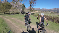
Photos of Bethlehem Plaas Mountain Bike
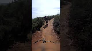
Videos of Bethlehem Plaas Mountain Bike
trail: Afterburner
0:21 |
148 |
Jun 9, 2021

youtuber
![Chasing locals at Banhoek South Africa //...]()

trail: Afterburner
2:12 |
130 |
Jan 30, 2025 , Stellenbosch


Recent Trail Reports
| status | trail | date | condition | info | user |
|---|---|---|---|---|---|
| Cobra | Jun 16, 2026 @ 11:05am (Africa/Maseru) Jun 16, 2026 | Ideal | SchalkMarais | ||
| Klipwerf | Jun 16, 2026 @ 11:05am (Africa/Maseru) Jun 16, 2026 | Ideal | SchalkMarais | ||
| Afterburner | Jun 16, 2026 @ 11:05am (Africa/Maseru) Jun 16, 2026 | Variable | SchalkMarais | ||
| Contour connector | Dec 26, 2025 @ 7:04am (Africa/Maseru) Dec 25, 2025 | Ideal | john-van-esch Wine Lands | ||
| Connector to Elevator | Dec 26, 2025 @ 7:04am (Africa/Maseru) Dec 25, 2025 | Ideal | john-van-esch Wine Lands | ||
| Dig Bos | Oct 18, 2025 @ 7:58am (Africa/Johannesburg) Oct 17, 2025 | Variable | headshot TokaiMTB | ||
| Bethlehem Ascent to Nick Nacks | Jul 13, 2025 @ 9:38am Jul 13, 2025 | Ideal | gravelpatrol | ||
| Bethlehem Gate | Jul 13, 2025 @ 12:05pm Jul 13, 2025 | Ideal | Eb4dv8 | ||
| Game Trail easy up | Jan 22, 2025 @ 10:43am Jan 22, 2025 | Very Dry | Robi49 | ||
| Fence Trail | Jan 13, 2024 @ 1:14am Jan 13, 2024 | Ideal | faniefiets |
Activity Feed
| username | action | type | title | date |
|---|---|---|---|---|
| SchalkMarais | add | report | activity #97166107 and 2 more | Jun 17, 2026 @ 12:06am 2 days |
| ArnoutA72e3c | ridden | trail | activity #95947849 | May 31, 2026 @ 9:15am May 31, 2026 |
| Zapcatdan | add | report | activity #89946944 | Mar 4, 2026 @ 6:12am Mar 4, 2026 |
| bobiwasabi | ridden | trail | activity #89560554 and 1 more | Feb 26, 2026 @ 12:08am Feb 26, 2026 |
| gusquovadis | wishlist | trail | activity #87460680 and 2 more | Jan 18, 2026 @ 11:59pm Jan 18, 2026 |
Recent Comments
| username | type | title | comment | date |
|---|---|---|---|---|
| trail | Superb! | May 18, 2025 @ 8:17am May 18, 2025 | ||
| trail | A true Gem of a Trail!!! | Mar 7, 2025 @ 1:20am Mar 7, 2025 | ||
| report | Perfect conditions | Aug 20, 2023 @ 2:44pm Aug 20, 2023 | ||
| trail | Wow | Jul 5, 2021 @ 12:37am Jul 5, 2021 | ||
| trail | Trail is open. | Feb 13, 2021 @ 7:24am Feb 13, 2021 |
Nearby Areas
| name | distance | ||||
|---|---|---|---|---|---|
| Banhoek Conservancy Trails | 16 | 13 | 1 | 0.7 km | |
| Hellsend Dirt Compound | 4 | 0.8 km | |||
| Boschendal Wine Farm | 12 | 10 | 2.2 km | ||
| Idas Valley Nature Area | 3 | 3 km | |||
| STF Botmaskop | 4 | 7 | 3.1 km |
Local Badges
-

Completionist0 awarded
Local Trail Supporters
![]()
- Old Bethlehem Trail team
![]()
- Old Bethlehem Farm
Activity Type Stats
| activitytype | trails | distance | descent | descent distance | total vertical | rating | global rank | state rank | photos | reports | routes | ridelogs |
|---|---|---|---|---|---|---|---|---|---|---|---|---|
| Mountain Bike | 22 | 13 miles | 2,346 ft | 7 miles | 1,240 ft | #3,591 | #69 | 20 | 252 | 1 | 1,634 | |
| E-Bike | 22 | 13 miles | 2,346 ft | 7 miles | 1,240 ft | #3,470 | #145 | 246 | 263 | |||
| Hike | 21 | 12 miles | 1,568 ft | 5 miles | 1,240 ft | #6,530 | #165 | 2 | 252 | 64 | ||
| Trail Running | 21 | 12 miles | 1,568 ft | 5 miles | 1,240 ft | #5,625 | #158 | 250 | 189 |
Frequently Asked Questions About Bethlehem Plaas
▼
What are the highest rated mountain biking trails in Bethlehem Plaas?
The highest rated mountain biking trails in Bethlehem Plaas are:
- Cobra (4.3/5)
- Klipwerf (4.3/5)
- Afterburner (4.3/5)
- Another Connector (4.1/5)
- Game Trail easy up (4/5)
▼
What is the best time of the year to ride in Bethlehem Plaas?
Based on ride log data, the most popular months to ride in Bethlehem Plaas are:
- October (7 activities)
- April (6 activities)
- June (5 activities)
▼
Where can I park to ride in Bethlehem Plaas?
There are 1 parking locations listed in Bethlehem Plaas. The most popular parking spots are:
▼
What is the longest trail in Bethlehem Plaas?
The longest trail in Bethlehem Plaas is Bethlehem Ascent to Nick Nacks at 2.0 km. View all trails sorted by distance.
Activities
Trails
- By Wynbass Bethlehem & contributors
- Admins: STF, Bethlehem
- #45076 - 5,760 views
- bethlehem plaas activity log | embed map of Bethlehem Plaas mountain bike trails | bethlehem plaas mountain biking points of interest
Downloading of trail gps tracks in kml & gpx formats is enabled for Bethlehem Plaas.
You must login to download files.