close
-
Layers w
- Weather Layers
- Pro
- Pro
- Pro
- Pro
- Pro
- Pro
- More Layers
- Pro
- Pro
- Pro
- Pro
-
Upgrade to

3D
Trail Conditions
- Unknown
- Snow Groomed
- Snow Packed
- Snow Covered
- Snow Cover Partial
- Freeze/thaw Cycle
- Icy
- Prevalent Mud
- Wet
- Variable
- Ideal
- Dry
- Very Dry
Trail Flow (Ridden Direction)
Trailforks scans users ridelogs to determine the most popular direction each trail is ridden. A good flowing trail network will have most trails flowing in a single direction according to their intension.
The colour categories are based on what percentage of riders are riding a trail in its intended direction.
The colour categories are based on what percentage of riders are riding a trail in its intended direction.
- > 96%
- > 90%
- > 80%
- > 70%
- > 50%
- < 50%
- bi-directional trail
- no data
Trail Last Ridden
Trailforks scans ridelogs to determine the last time a trail was ridden.
- < 2 days
- < 1 week
- < 2 weeks
- < 1 month
- < 6 months
- > 6 months
Trail Ridden Direction
The intended direction a trail should be ridden.
- Downhill Only
- Downhill Primary
- Both Directions
- Uphill Primary
- Uphill Only
- One Direction
Contribute Details
Colors indicate trail is missing specified detail.
- Description
- Photos
- Description & Photos
- Videos
Trail Popularity ?
Trailforks scans ridelogs to determine which trails are ridden the most in the last 9 months.
Trails are compared with nearby trails in the same city region with a possible 25 colour shades.
Think of this as a heatmap, more rides = more kinetic energy = warmer colors.
- most popular
- popular
- less popular
- not popular
ATV/ORV/OHV Filter
Max Vehicle Width
inches
US Cell Coverage
Legend

Radar Time
Activity Recordings
Trailforks uses anonymized public activity data.
?
Activity Recordings
Trailforks uses anonymized public activity data.
?
Personal Heatmap
▶
Activity Types
all
/
none
▶
Options
2
Date range
month
–
Winter Trails
Warning
A routing network for winter maps does not exist. Selecting trails using the winter trails layer has been disabled.
Missing Trails
Most Popular
Least Popular
Trails are colored based on popularity. The more popular a trail is, the more red. Less popular trails trend towards green.
Jump Magnitude Heatmap
Heatmap of where riders jump on trails. Zoom in to see individual jumps, click circles to view jump details.
BC Backroad Status
![map legend]()
Service Road Atlas is a free to use, community-driven service for viewing and creating reports on the numerous back-country service roads around B.C. and Alberta.

Slope Aspect
Direction the slope faces
Trails Deemphasized
Trails are shown in grey.
Only show trails with no bike usage.
Suggested Layers
Based on selected activity type
Save the current map location and zoom level as your default home location whenever this page is loaded.
Save
No description for Bielsa has been added yet!
Login or register to submit one.
This region uses the Uk/Euro style trail grading system.
Activities Click to view
- Mountain Bike
104 trails
- E-Bike
104 trails
- Gravel Bike
0 trails
- Adaptive Bike
0 trails
- Hike
126 trails
- Trail Running
127 trails
Region Details
- 42
- 18
- 28
- 13
Region Status
Open as of 2 daysStats
- Avg Trail Rating
- Trails (view details)
- 124
- Trails Mountain Bike
- 104
- Trails E-Bike
- 104
- Trails Hike
- 127
- Trails Trail Running
- 127
- Total Distance
- 201 miles
- Total Descent Distance
- 87 miles
- Total Descent
- 72,253 ft
- Total Vertical
- 7,479 ft
- Highest Trailhead
- 10,070 ft
- Reports
- 867
- Photos
- 546
- Ridden Counter
- 7,188
Sub Regions
-
Bielsa
- 18
- 27
- 13
Popular Bielsa Mountain Biking Trails
• 100 ★ 5.0 • 1 mile • 20 ft • 302 •
Sendero flow, limpio, con curvas y z's que te harán disfrutar, algún escalón no muy potente, pero sobre todo muy divertida.
• 100 ★ 4.8 • 4,951 ft • 61 ft • 270 •
De entrada hay que salvar un buen tramo de subida que pocos podrán hacer montados por pendiente y técnica, quizás con e-bike...luego es sendero disfruton por bosque, con algún pasito para darle interés
• 95 ★ 4.6 • 2 miles • 62 ft • 253 •
Descenso del pico Comodoto. La primera parte con mucha pendiente y terreno suelto, pocos lo harán montados todo... Despues senda entre prados muy bonita para disfrutar del ambiente.
• 100 ★ 4.7 • 3,911 ft • 0 ft • 245 •
De las mejores de la zona, combina de todo lo mejor, flow natural, raíces, saltos naturales, pendiente, curvas cerradas y el tramo final con algo de piedra. En mojado es mucho más complicada porque en los toboganes es difícil parar....
• 90 ★ 4.2 • 2,349 ft • 528 ft • 244 •
Subida a Comodoto desde Plana Fonda. Mayormente porteo y empujar. Mientras subimos podremos deleitarnos con la norte del Monte Perdido.
• 100 ★ 4.6 • 2,142 ft • 0 ft • 234 •
Final del camino " ", los últimos 200 metros son comunes con el GR " ", así que por favor respeta al resto de usuarios!
• 80 ★ 4.7 • 1 mile • 24 ft • 229 •
Excelente camino para bajar de Espierba al camping. Ambiente forestal mayormente muy frondoso. Mucha tierra vegetal y bastante ancho, muy gozoso.
• 75 ★ 4.5 • 2,595 ft • 0 ft • 218 •
Sendero con partes flow por bosque, pero con tramos de fuerte pendiente, en curva, escalones y pasos estrechos entre rocas, raices.
Bielsa Mountain Bike Routes
★ 5.0 • 15 miles • 4,106 ft • 6 • Loop •
Versión eBike de la ruta clásica del Comodoto. En esta ocasión subimos a Espierba por una senda que...
★ 5.0 • 14 miles • 4,188 ft • 6 • Loop •
TIEMPO: 4h. - 5h. h CON BARRO: Factible BALIZADA: GPS ZONA: Bielsa SALIDA: Camping de Pineta LLEGADA:...
★ 5.0 • 32 miles • 9,077 ft • 7 • Loop •
TIEMPO: 11h. - 13h. h CON BARRO: Factible BALIZADA: No. GPS ZONA: Bielsa SALIDA: Bielsa LLEGADA: Bielsa...
★ 3.5 • 14 miles • 4,942 ft • 4 • Loop •
TIEMPO: 7h. - 8h. h CON BARRO: Factible BALIZADA: No. GPS ZONA: Bielsa SALIDA: Hospital de Parzán...
★ 4.0 • 26 miles • 7,244 ft • 1 • Loop •
BALIZADA: GPS ZONA: Bielsa SALIDA: Bielsa LLEGADA: Bielsa VARIANTES: No tiene DESCRIPCIÓN Un reto...
★ 4.0 • 16 miles • 3,405 ft • 2 • Loop •
TIEMPO: 3h - 3:30h h CON BARRO: Factible BALIZADA: GPS ZONA: Bielsa SALIDA: Camping Pineta LLEGADA:...
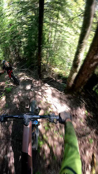
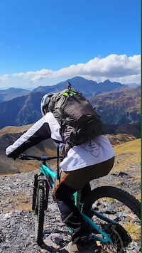
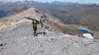
Photos of Bielsa Mountain Bike
Videos of Bielsa Mountain Bike
trail: Supergrass
0:51 |
46 |
Jan 29, 2026
trail: Bachimala to Viadós
0:29 |
14 |
Oct 11, 2025
trail: Suelza Climb
0:51 |
140 |
Jul 31, 2021
trail: Llanos del Due
2:04 |
94 |
May 31, 2021
youtuber
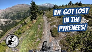
![My most epic day of mountainbiking - Pyrenees...]()
16:07 |
66 |
Sep 8, 2025 , Bielsa
youtuber
![This was supposed to be an easier day!! -...]()
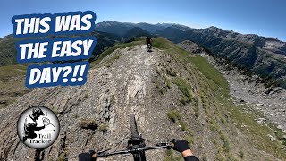
trail: Llanos del Due
13:25 |
82 |
Sep 1, 2025 , Bielsa

trail: Llanos del Due
12:12 |
56 |
Aug 9, 2025 , Bielsa
trail: Sarratillons
12:12 |
61 |
Aug 9, 2025 , Bielsa
Current Trail Warnings
| status | trail | date | condition | user | info |
|---|---|---|---|---|---|
| Enlace Comodoto-Llanos del Due Superior | May 29, 2026 @ 1:22pm (Europe/Madrid) May 29, 2026 | Snow Cover Partial | marcossantamaria TFSPAIN | Hay que cruzar 2 neveros, y la subida... |
Recent Trail Reports
| status | trail | date | condition | info | user |
|---|---|---|---|---|---|
| Ska-güesss | Jun 8, 2026 @ 8:26am (Pacific/Midway) Jun 8, 2026 | Dry | Kalamarrrrrdo TFSPAIN | ||
| Acceso Ska-güesss | Jun 8, 2026 @ 8:26am (Pacific/Midway) Jun 8, 2026 | Dry | Kalamarrrrrdo TFSPAIN | ||
| Enlace Suelza Line Intermedio | Jun 8, 2026 @ 8:26am (Pacific/Midway) Jun 8, 2026 | Dry | Kalamarrrrrdo TFSPAIN | ||
| Las Costadieras | Jun 8, 2026 @ 10:25am (Europe/Andorra) Jun 8, 2026 | Dry | Kalamarrrrrdo TFSPAIN | ||
| Sarratillons | Jun 8, 2026 @ 10:25am (Europe/Andorra) Jun 8, 2026 | Dry | Kalamarrrrrdo TFSPAIN | ||
| Llanos del Due | Jun 8, 2026 @ 10:25am (Europe/Andorra) Jun 8, 2026 | Dry | Kalamarrrrrdo TFSPAIN | ||
| Alcorce Comodoto | Jun 8, 2026 @ 10:25am (Europe/Andorra) Jun 8, 2026 | Dry | Kalamarrrrrdo TFSPAIN | ||
| Enlace Comodoto-Llanos del Due Inferior | Jun 8, 2026 @ 10:25am (Europe/Andorra) Jun 8, 2026 | Dry | Kalamarrrrrdo TFSPAIN | ||
| Comodoto (Espierba - La Estiva) | Jun 8, 2026 @ 10:25am (Europe/Andorra) Jun 8, 2026 | Dry | Kalamarrrrrdo TFSPAIN | ||
| Espierba.Acceso Comodoto | Jun 8, 2026 @ 10:25am (Europe/Andorra) Jun 8, 2026 | Dry | Kalamarrrrrdo TFSPAIN |
Activity Feed
| username | action | type | title | date |
|---|---|---|---|---|
| angelonzz | add | report | activity #97196692 | Jun 17, 2026 @ 11:02am 2 days |
| belbeb | ridden | trail | activity #97130242 and 9 more | Jun 16, 2026 @ 12:15pm 3 days |
| Kalamarrrrrdo | difficultyvote | trail | activity #97093993 | Jun 16, 2026 @ 1:27am Jun 16, 2026 |
| Kalamarrrrrdo | comment | trail | activity #97093942 and 1 more | Jun 16, 2026 @ 1:25am Jun 16, 2026 |
| Kalamarrrrrdo | vote | trail | activity #97093889 and 2 more | Jun 16, 2026 @ 1:23am Jun 16, 2026 |
Recent Comments
| username | type | title | comment | date |
|---|---|---|---|---|
| trail | Los anteriores comentarios son anteriores a la... | Jun 16, 2026 @ 1:30am Jun 16, 2026 | ||
| trail | Imprescindible si estás en la zona, puntos a... | Jun 16, 2026 @ 1:25am Jun 16, 2026 | ||
| trail | Desde la asociación Bielsa Trocs recordamos... | Jun 10, 2026 @ 6:11am Jun 10, 2026 | ||
| report | Por estos reportes es que pago el premium | May 29, 2026 @ 6:04am May 29, 2026 | ||
| trail | Great one! Enduro classics! | May 21, 2026 @ 9:59am May 21, 2026 |
Local Badges
-

Epic Ride Climb 2k200 awarded -

Climbing 10k Badge16 awarded -

Climbing 100k Badge0 awarded -

Epic Ride Descent 2k280 awarded -

Descent 10k Badge29 awarded -

Descent 100k Badge0 awarded
Activity Type Stats
| activitytype | trails | distance | descent | descent distance | total vertical | rating | global rank | state rank | photos | reports | routes | ridelogs |
|---|---|---|---|---|---|---|---|---|---|---|---|---|
| Mountain Bike | 104 | 166 miles | 59,777 ft | 72 miles | 7,480 ft | #1,264 | #123 | 538 | 867 | 14 | 1,727 | |
| E-Bike | 104 | 166 miles | 59,777 ft | 72 miles | 7,480 ft | #663 | #181 | 4 | 867 | 13 | 535 | |
| Hike | 126 | 201 miles | 72,254 ft | 87 miles | 7,480 ft | #820 | #113 | 2 | 867 | 2 | 384 | |
| Trail Running | 127 | 201 miles | 72,254 ft | 87 miles | 7,480 ft | #635 | #118 | 1 | 867 | 2 | 60 |
Frequently Asked Questions About Bielsa
▼
What are the best places to ride in Bielsa?
Bielsa has 1 areas to explore for mountain biking. The top rated areas are:
▼
What are the highest rated mountain biking trails in Bielsa?
The highest rated mountain biking trails in Bielsa are:
- Las Costadieras (4.8/5)
- Sarratillons (4.7/5)
- Ska-güesss (4.6/5)
- Subicierro Superior (4.6/5)
- Cazadores (4.5/5)
▼
What is the best time of the year to ride in Bielsa?
Based on ride log data, the most popular months to ride in Bielsa are:
- August (15 activities)
- July (13 activities)
- October (10 activities)
▼
Where can I park to ride in Bielsa?
There are 4 parking locations listed in Bielsa. The most popular parking spots are: View all parking and trailhead locations on the map to plan your visit.
Activities
Trails
Points of Interest
- Cabaña de Ordices Cabin
- Camping Bielsa
- Refugio Pescadores Cabin
- Refugio Cubilar de las Vacas Cabin
- Cabaña Los Güertos Cabin
- Refugio de Montinier Cabin
- Hospital de Gistaín Sight
- Cabana de Barleto Cabin
- Refugio de Urdiceto Cabin
- Refugio de Barrosa Cabin
- Mallo de Marmorés / Cilindro de Marboré (10,794 ft)
- Pundeta de Peña Roya (10,253 ft)
- Pico de l'Almunia Gran (10,180 ft)
- By paco-jones
 & contributors
 - Admins: juanx, Kalamarrrrrdo
- #19327 - 6,268 views
- bielsa activity log | embed map of Bielsa mountain bike trails | bielsa mountain biking points of interest
Downloading of trail gps tracks in kml & gpx formats is enabled for Bielsa.
You must login to download files.