close
-
Layers w
- Weather Layers
- Pro
- Pro
- Pro
- Pro
- Pro
- Pro
- More Layers
- Pro
- Pro
- Pro
- Pro
-
Upgrade to

3D
Trail Conditions
- Unknown
- Snow Groomed
- Snow Packed
- Snow Covered
- Snow Cover Partial
- Freeze/thaw Cycle
- Icy
- Prevalent Mud
- Wet
- Variable
- Ideal
- Dry
- Very Dry
Trail Flow (Ridden Direction)
Trailforks scans users ridelogs to determine the most popular direction each trail is ridden. A good flowing trail network will have most trails flowing in a single direction according to their intension.
The colour categories are based on what percentage of riders are riding a trail in its intended direction.
The colour categories are based on what percentage of riders are riding a trail in its intended direction.
- > 96%
- > 90%
- > 80%
- > 70%
- > 50%
- < 50%
- bi-directional trail
- no data
Trail Last Ridden
Trailforks scans ridelogs to determine the last time a trail was ridden.
- < 2 days
- < 1 week
- < 2 weeks
- < 1 month
- < 6 months
- > 6 months
Trail Ridden Direction
The intended direction a trail should be ridden.
- Downhill Only
- Downhill Primary
- Both Directions
- Uphill Primary
- Uphill Only
- One Direction
Contribute Details
Colors indicate trail is missing specified detail.
- Description
- Photos
- Description & Photos
- Videos
Trail Popularity ?
Trailforks scans ridelogs to determine which trails are ridden the most in the last 9 months.
Trails are compared with nearby trails in the same city region with a possible 25 colour shades.
Think of this as a heatmap, more rides = more kinetic energy = warmer colors.
- most popular
- popular
- less popular
- not popular
ATV/ORV/OHV Filter
Max Vehicle Width
inches
US Cell Coverage
Legend

Radar Time
Activity Recordings
Trailforks uses anonymized public activity data.
?
Activity Recordings
Trailforks uses anonymized public activity data.
?
Personal Heatmap
▶
Activity Types
all
/
none
▶
Options
2
Date range
month
–
Winter Trails
Warning
A routing network for winter maps does not exist. Selecting trails using the winter trails layer has been disabled.
Missing Trails
Most Popular
Least Popular
Trails are colored based on popularity. The more popular a trail is, the more red. Less popular trails trend towards green.
Jump Magnitude Heatmap
Heatmap of where riders jump on trails. Zoom in to see individual jumps, click circles to view jump details.
BC Backroad Status
![map legend]()
Service Road Atlas is a free to use, community-driven service for viewing and creating reports on the numerous back-country service roads around B.C. and Alberta.

Slope Aspect
Direction the slope faces
Trails Deemphasized
Trails are shown in grey.
Only show trails with no bike usage.
Suggested Layers
Based on selected activity type
Save the current map location and zoom level as your default home location whenever this page is loaded.
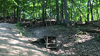
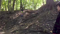
SaveThe Bloomer Park trails are a fun mixture of technical single track and scenic two track that is under active development. Follow the signed route or piece something together by mixing up the two track and single track, exploring what this beautiful park has to offer.
Primary Trail Type: Cross-Country
eBikes Allowed:
No
 google parking directions
Files
- CRAMBA_Bloomer_2015-Mar-17.pdf (161 KB)
Region Supporters & Maintainers
- Erik Silvassy
trail builderMaintainer
Activities Click to view
- Mountain Bike
4 trails
- Hike
4 trails
- Trail Running
4 trails
Region Details
- 1
- 1
Region Status
Open as of Apr 12, 2026Stats
- Avg Trail Rating
- Trails (view details)
- 2
- Trails Mountain Bike
- 4
- Trails E-Bike
- 1
- Trails Hike
- 4
- Trails Trail Running
- 4
- Total Distance
- 7 miles
- Total Descent
- 881 ft
- Total Vertical
- 114 ft
- Highest Trailhead
- 798 ft
- Reports
- 56
- Photos
- 22
- Ridden Counter
- 673
Popular Bloomer Park Mountain Biking Trails
• 75 ★ 4.4 • 7 miles • 550 ft • 371 •
This is a great trail for experienced riders in southeast Michigan. It offers some big drops and decent descents. If you come from out of state/somewhere that has harder trails this might be a easier ride. Locals might find this trail...
Bloomer Park Mountain Bike Routes
7 miles • 489 ft • 1 • Loop •
This is one of my favorite local XC trails to ride. It consist of 7 miles of single-track with a lot of...
Photos of Bloomer Park Mountain Bike
Videos of Bloomer Park Mountain Bike
trail: Bloomer Trail
0:07 |
372 |
Dec 7, 2020
trail: Bloomer Trail
0:11 |
484 |
Nov 10, 2019
youtuber
![Searching for Gnar at Bloomer Park •...]()

trail: Bloomer Trail
10:51 |
1406 |
Oct 29, 2018 , Rochester
Recent Trail Reports
| status | trail | date | condition | info | user |
|---|---|---|---|---|---|
| Bloomer Trail | Apr 12, 2026 @ 12:33pm (America/Detroit) Apr 12, 2026 | Variable | Kz44tz |
Activity Feed
| username | action | type | title | date |
|---|---|---|---|---|
| Todd8DRC9M | vote | trail | activity #97410271 | Jun 20, 2026 @ 10:23am 1 day |
| moizsb | add | photo | activity #93538044 and 9 more | Apr 27, 2026 @ 1:40pm Apr 27, 2026 |
| Kz44tz | add | report | activity #92495700 | Apr 12, 2026 @ 1:40pm Apr 12, 2026 |
| CullenXdKBO8 | wishlist | trail | activity #92480704 | Apr 12, 2026 @ 9:29am Apr 12, 2026 |
| pintail253 | wishlist | route | activity #92253862 | Apr 9, 2026 @ 8:08am Apr 9, 2026 |
Recent Comments
| username | type | title | comment | date |
|---|---|---|---|---|
| trail | This trail has a ton of potential, and I can... | Sep 16, 2025 @ 8:39pm Sep 16, 2025 | ||
| trail | Info is a bit outdated. Class 1 e-bikes are... | Aug 2, 2023 @ 5:53pm Aug 2, 2023 | ||
| trail | Should be a black trail if you ride all the... | Nov 8, 2022 @ 8:17am Nov 8, 2022 | ||
| trail | This trail is recommended to anyone who is... | Jun 14, 2022 @ 3:20pm Jun 14, 2022 | ||
| trail | Lots of fun! Some good flow and proper hand... | Sep 24, 2020 @ 6:18am Sep 24, 2020 |
Nearby Areas
| name | distance | ||||
|---|---|---|---|---|---|
| Chief Gene Shepherd Park | 11 | 1.2 km | |||
| Stony Creek Metropark | 13 | 5 | 6 | 3.1 km | |
| River Bends Park | 1 | 6 | 3 | 3.4 km | |
| Clinton River Park Trails | 2 | 3 | 7.6 km | ||
| Bald Mountain Recreation Area (South) | 7 | 3 | 7.7 km |
Activity Type Stats
| activitytype | trails | distance | descent | descent distance | total vertical | rating | global rank | state rank | photos | reports | routes | ridelogs |
|---|---|---|---|---|---|---|---|---|---|---|---|---|
| Mountain Bike | 4 | 7 miles | 879 ft | 3 miles | 115 ft | #6,448 | #2,435 | 23 | 56 | 1 | 4,114 | |
| E-Bike | 1 | 44 | 28 | |||||||||
| Hike | 4 | 7 miles | 879 ft | 3 miles | 115 ft | #14,868 | #6,613 | 56 | 207 | |||
| Trail Running | 4 | 7 miles | 879 ft | 3 miles | 115 ft | #13,406 | #5,564 | 56 | 202 |
- By markholloway
 Trailforks Map Team & contributors
 - Admins: CRAMBA, MCMBA
- #11278 - 8,995 views
- bloomer park activity log | embed map of Bloomer Park mountain bike trails | bloomer park mountain biking points of interest
Downloading of trail gps tracks in kml & gpx formats is enabled for Bloomer Park.
You must login to download files.