close
-
Layers w
- Weather Layers
- Pro
- Pro
- Pro
- Pro
- Pro
- Pro
- More Layers
- Pro
- Pro
- Pro
- Pro
-
Upgrade to

3D
Trail Conditions
- Unknown
- Snow Groomed
- Snow Packed
- Snow Covered
- Snow Cover Partial
- Freeze/thaw Cycle
- Icy
- Prevalent Mud
- Wet
- Variable
- Ideal
- Dry
- Very Dry
Trail Flow (Ridden Direction)
Trailforks scans users ridelogs to determine the most popular direction each trail is ridden. A good flowing trail network will have most trails flowing in a single direction according to their intension.
The colour categories are based on what percentage of riders are riding a trail in its intended direction.
The colour categories are based on what percentage of riders are riding a trail in its intended direction.
- > 96%
- > 90%
- > 80%
- > 70%
- > 50%
- < 50%
- bi-directional trail
- no data
Trail Last Ridden
Trailforks scans ridelogs to determine the last time a trail was ridden.
- < 2 days
- < 1 week
- < 2 weeks
- < 1 month
- < 6 months
- > 6 months
Trail Ridden Direction
The intended direction a trail should be ridden.
- Downhill Only
- Downhill Primary
- Both Directions
- Uphill Primary
- Uphill Only
- One Direction
Contribute Details
Colors indicate trail is missing specified detail.
- Description
- Photos
- Description & Photos
- Videos
Trail Popularity ?
Trailforks scans ridelogs to determine which trails are ridden the most in the last 9 months.
Trails are compared with nearby trails in the same city region with a possible 25 colour shades.
Think of this as a heatmap, more rides = more kinetic energy = warmer colors.
- most popular
- popular
- less popular
- not popular
ATV/ORV/OHV Filter
Max Vehicle Width
inches
US Cell Coverage
Legend

Radar Time
Activity Recordings
Trailforks uses anonymized public activity data.
?
Activity Recordings
Trailforks uses anonymized public activity data.
?
Personal Heatmap
▶
Activity Types
all
/
none
▶
Options
2
Date range
month
–
Winter Trails
Warning
A routing network for winter maps does not exist. Selecting trails using the winter trails layer has been disabled.
Missing Trails
Most Popular
Least Popular
Trails are colored based on popularity. The more popular a trail is, the more red. Less popular trails trend towards green.
Jump Magnitude Heatmap
Heatmap of where riders jump on trails. Zoom in to see individual jumps, click circles to view jump details.
BC Backroad Status
![map legend]()
Service Road Atlas is a free to use, community-driven service for viewing and creating reports on the numerous back-country service roads around B.C. and Alberta.

Slope Aspect
Direction the slope faces
Trails Deemphasized
Trails are shown in grey.
Only show trails with no bike usage.
Suggested Layers
Based on selected activity type
Save the current map location and zoom level as your default home location whenever this page is loaded.
SaveThis 4,900-acre recreation area includes 41 miles of system trails and is a popular spot for locals and visitors because of its proximity to the city of Missoula and the views of the Missoula valley, and the Sapphire and Rattlesnake mountains. Blue Mountain Recreation Area East Zone is a day use area only; the area is closed 10 p.m. to 6 a.m. The lower trails near the parking areas are very popular for hikers and dog walkers, so please keeps speeds low on these trails and always yield to other users.
Rides typically start from the main lower parking lot trailhead located at the corner of Blue Mountain Rd and Forest Hills Dr. Riders generally head up on the main Corridor Trail 3.04 or Out and Back 3.08 and aim for either Rocky Top or the Moto Trailhead. From either of these high points, a rider has several choices to descend for an after-work quickie, or one can head up higher to the top of the Hayes Creek descent (bonus points for doing the Summit Loop Trail). From here, its a fast flow fest back down on the Hayes Creek Trail and out Why Not (or double bonus for climbing back out Moto Line and dropping the front side (GI Joe/Carcass or Rocky Top/Out and Back)
If you're feeling exploratory and/or hankering for some rocks after riding the Rattlesnake , moto trails like J's Trail, Orchard, Rocks & Roots and Deadmans Point Loop will scratch that itch.
The crown jewel (in the eyes of the right beholder) of the Blue Mountain system is a giant loop to the top of Blue Mountain (see Trailforks route). From the lookout tower at the top, a super rowdy and loose 3,000 ft descent will take you all the way back down to the main trailhead. See the route entitled Deadmans Ridge - Big Loop.
Rides typically start from the main lower parking lot trailhead located at the corner of Blue Mountain Rd and Forest Hills Dr. Riders generally head up on the main Corridor Trail 3.04 or Out and Back 3.08 and aim for either Rocky Top or the Moto Trailhead. From either of these high points, a rider has several choices to descend for an after-work quickie, or one can head up higher to the top of the Hayes Creek descent (bonus points for doing the Summit Loop Trail). From here, its a fast flow fest back down on the Hayes Creek Trail and out Why Not (or double bonus for climbing back out Moto Line and dropping the front side (GI Joe/Carcass or Rocky Top/Out and Back)
If you're feeling exploratory and/or hankering for some rocks after riding the Rattlesnake
The crown jewel (in the eyes of the right beholder) of the Blue Mountain system is a giant loop to the top of Blue Mountain (see Trailforks route). From the lookout tower at the top, a super rowdy and loose 3,000 ft descent will take you all the way back down to the main trailhead. See the route entitled Deadmans Ridge - Big Loop.
source: Lolo NF
Primary Trail Type: Cross-Country
Land Status: National Forest
Land Manager: USFS
 google parking directions
 Access Info:
The main trailhead parking area is at the intersection of Blue Mountain Rd and Forest Hills Ln. There are also several parking areas along Blue Mountain Rd #365, including the Moto trailhead at the second switchback. Due to USFS rules on E-bike access, only the motorized trails accessible from the Moto trailhead are open to e-bikes.
Links
Region Supporters & Maintainers
![]()
MTB MissoulaMaintainer
Activities Click to view
- Mountain Bike
60 trails
- E-Bike
17 trails
- Horse
50 trails
- Hike
75 trails
- Trail Running
77 trails
- Dirtbike/Moto
15 trails
- ATV/ORV/OHV
7 trails
- Snowshoe
51 trails
Stats
- Avg Trail Rating
- Trails (view details)
- 76
- Trails Mountain Bike
- 61
- Trails E-Bike
- 17
- Trails Horse
- 50
- Trails Hike
- 77
- Trails Trail Running
- 77
- Trails Dirtbike/Moto
- 15
- Trails ATV/ORV/OHV
- 7
- Trails Snowshoe
- 51
- Total Distance
- 134 miles
- Total Descent
- 28,324 ft
- Total Vertical
- 5,138 ft
- Highest Trailhead
- 8,251 ft
- Reports
- 1,462
- Photos
- 278
- Ridden Counter
- 14,044
Popular Blue Mountain Mountain Biking Trails
• 85 ★ 3.5 • 2 miles • 747 ft • 565 •
Main thoroughfare good access from the main trailhead to the .
• 95 ★ 2.7 • 2,382 ft • 0 ft • 542 •
Fun fast decent but watch out for the logs at the end to keep Motorcycles out.
• 90 ★ 4.0 • 1 mile • 7 ft • 534 •
Great biking decent, However beware of motorcycles coming up the trail. Super fun berms and flow.
• 90 ★ 4.3 • 3,581 ft • 38 ft • 468 •
Access from . The first section is fun single track, the second decent is steep and rocky with multiple small drops with options for bigger. Watch for loose rock.
• 80 ★ 3.4 • 1 mile • 124 ft • 394 •
There are a few rocky spots on this section and some tight switch backs right when you start flowing. If you are climbing this trail there is a short technical burst right near the top of the knob.
• 90 ★ 3.5 • 4,711 ft • 303 ft • 387 •
The trail starts with a mellow traverse across an open grassy slope passing by a spring as it climbs toward the trees. The trail enters the forest and switchbacks up the hill passing by several small rocky cliffs. After reaching a...
• 85 ★ 2.8 • 1 mile • 152 ft • 386 •
The lower portion of the starts at the main parking lot and climbs up a broad dirt path to the northwest. The trail narrows before entering the first of two draws and then traverses across an open slope before intersecting Blue Mountain...
Blue Mountain Mountain Bike Routes
★ 5.0 • 4 miles • 76 ft • 1 •
This is one of our favorite routes in Missoula and is featured in Freehub Magazine's Montana Photo Book:...
★ 4.0 • 8 miles • 1,466 ft • 14 • Loop •
A chill afternoon loop with a flowy descent down and a more technical descent down trail.
★ 5.0 • 17 miles • 3,291 ft • 24 • Loop •
Wanna do with (or without) a shuttle? This is it. This loop takes some dedication going up on the forest...
★ 2.0 • 7 miles • 1,191 ft • 2 •
A classic Blue Mountain route with a little bit of everything. The climb is mostly gradual and varied...
10 miles • 2,428 ft • 3 • Shuttled •
Maybe the easiest true alpine ride you'll ever do. You can shuttle from Fort Fizzle on Hwy 12 up to the...
★ 3.0 • 10 miles • 1,984 ft • 20 • Loop •
This is a good quick sampler of the trails at Blue Mountain. Takes you on a few of the classic front side...
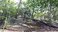
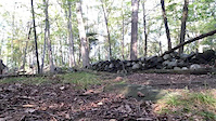
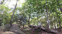
Photos of Blue Mountain Mountain Bike
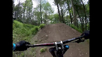
Videos of Blue Mountain Mountain Bike
trail: Blue Mountain Main Corridor
0:06 |
172 |
Sep 30, 2017
trail: Blue Mountain Main Corridor
0:08 |
72 |
Sep 30, 2017
trail: Blue Mountain Main Corridor
0:05 |
65 |
Sep 30, 2017
trail: Blue Mountain Main Corridor
0:58 |
196 |
May 30, 2017
trail: Blue Mountain Main Corridor
4:34 |
298 |
Oct 16, 2012

trail: Blue Mountain Main Corridor
6:55 |
367 |
Apr 13, 2011
youtuber
![South O'Brian Creek Loop - Blue Mountain -...]()
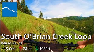
trail: South O'Brien Creek Loop
38:59 |
272 |
Jul 1, 2023 , Missoula
youtuber
![Trail #3.01 - Blue Mountain - Missoula, MT]()
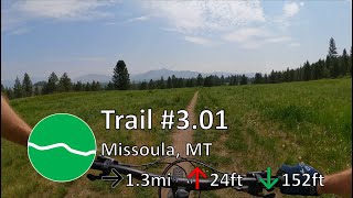
4:21 |
203 |
May 23, 2023 , Missoula
Recent Trail Reports
| status | trail | date | condition | info | user |
|---|---|---|---|---|---|
| Moto Line | Jun 17, 2026 @ 12:03pm (America/Creston) 3 days | Dry | johncc | ||
| Orchard | Jun 17, 2026 @ 12:03pm (America/Creston) 3 days | Dry | johncc | ||
| 6.01 - Moto Trail | Jun 17, 2026 @ 12:03pm (America/Creston) 3 days | Dry | johncc | ||
| Blue Mountain Lookout | May 11, 2026 @ 9:37am (America/Denver) May 11, 2026 | Variable | aaronrbaldwin TRAILFORKS | ||
| Pawn | May 11, 2026 @ 9:37am (America/Denver) May 11, 2026 | Ideal | aaronrbaldwin TRAILFORKS | ||
| Argillite Cliffs | May 11, 2026 @ 9:37am (America/Denver) May 11, 2026 | Ideal | aaronrbaldwin TRAILFORKS | ||
| Deadmans Ridge | May 9, 2026 @ 12:07am (America/Denver) May 8, 2026 | Ideal | Fanderson | ||
| Wilderness Trail | May 8, 2026 @ 6:23pm (America/Denver) May 8, 2026 | Ideal | Fanderson | ||
| Why Not | May 8, 2026 @ 6:23pm (America/Denver) May 8, 2026 | Ideal | Fanderson | ||
| Rocks n Roots | May 8, 2026 @ 6:23pm (America/Denver) May 8, 2026 | Ideal | Fanderson |
Activity Feed
| username | action | type | title | date |
|---|---|---|---|---|
| johncc | add | report | activity #97224305 and 2 more | Jun 17, 2026 @ 6:41pm 3 days |
| Pjtabaka | ridden | trail | activity #96718283 | Jun 10, 2026 @ 9:49pm Jun 10, 2026 |
| johncc | add | photo | activity #96574740 and 2 more | Jun 8, 2026 @ 5:26pm Jun 8, 2026 |
| Hannahjosie | ridden | trail | activity #96134766 | Jun 2, 2026 @ 9:23pm Jun 2, 2026 |
| RoberttLWVi1 | wishlist | trail | activity #96058365 | Jun 1, 2026 @ 7:35pm Jun 1, 2026 |
Recent Comments
| username | type | title | comment | date |
|---|---|---|---|---|
| trail | Nice route to the top with no real grunts. | May 28, 2026 @ 1:06pm May 28, 2026 | ||
| trail | Good trail to find “moto washboards “. As... | May 28, 2026 @ 1:03pm May 28, 2026 | ||
| trail | Fallen trees make it impassable as of this date. | May 28, 2026 @ 12:59pm May 28, 2026 | ||
| report | It’s money! Only ~3 or 4 puddles and no mud. | Apr 25, 2026 @ 11:34am Apr 25, 2026 | ||
| report | Love you guys! | Mar 24, 2026 @ 3:04pm Mar 24, 2026 |
Nearby Areas
| name | distance | ||||
|---|---|---|---|---|---|
| South Hills | 17 | 6 | 5.5 km | ||
| Pattee Canyon | 31 | 17 | 4 | 8.7 km | |
| Dean Stone | 5 | 5 | 10.1 km | ||
| Marshall Mountain | 7 | 10 | 3 | 1 | 13.3 km |
| Petty Mountain | 4 | 2 | 1 | 13.5 km |
Local Badges
-

Completionist0 awarded
Activity Type Stats
| activitytype | trails | distance | descent | descent distance | total vertical | rating | global rank | state rank | photos | reports | routes | ridelogs |
|---|---|---|---|---|---|---|---|---|---|---|---|---|
| Mountain Bike | 60 | 116 miles | 26,939 ft | 55 miles | 5,079 ft | #1,029 | #368 | 265 | 1,446 | 20 | 9,597 | |
| E-Bike | 17 | 45 miles | 12,684 ft | 22 miles | 3,898 ft | #2,974 | #922 | 3 | 1,277 | 189 | ||
| Horse | 50 | 88 miles | 15,919 ft | 32 miles | 3,898 ft | #520 | #273 | 467 | 1 | 2 | ||
| Hike | 75 | 132 miles | 27,343 ft | 58 miles | 5,138 ft | #957 | #486 | 10 | 1,450 | 4 | 1,181 | |
| Trail Running | 77 | 132 miles | 27,343 ft | 58 miles | 5,138 ft | #555 | #219 | 1,450 | 4 | 2,381 | ||
| Dirtbike/Moto | 15 | 48 miles | 13,934 ft | 25 miles | 3,898 ft | #494 | #133 | 367 | 15 | |||
| ATV/ORV/OHV | 7 | 35 miles | 6,519 ft | 15 miles | 3,898 ft | #369 | #93 | 310 | 2 | |||
| Snowshoe | 51 | 76 miles | 11,014 ft | 25 miles | 3,337 ft | #215 | #44 | 183 | 8 |
Frequently Asked Questions About Blue Mountain
▼
What are the highest rated mountain biking trails in Blue Mountain?
The highest rated mountain biking trails in Blue Mountain are:
- Carlton Ridge (4.5/5)
- Mill Creek (4.4/5)
- Rocks n Roots (4.3/5)
- Orchard (4.2/5)
- Carcass (4.2/5)
▼
What is the best time of the year to ride in Blue Mountain?
Based on ride log data, the most popular months to ride in Blue Mountain are:
- July (194 activities)
- April (184 activities)
- May (172 activities)
▼
Where can I park to ride in Blue Mountain?
There are 16 parking locations listed in Blue Mountain. The most popular parking spots are: View all parking and trailhead locations on the map to plan your visit.
▼
What is the longest trail in Blue Mountain?
The longest trail in Blue Mountain is Grave Creek Growler at 13.5 miles. View all trails sorted by distance.
Activities
Trails
Points of Interest
- By Fanderson
 & contributors
 - Admins: MMBC, aaronrbaldwin, MMBC
- #7434 - 23,132 views
- blue mountain activity log | embed map of Blue Mountain mountain bike trails | blue mountain mountain biking points of interest polygons
Downloading of trail gps tracks in kml & gpx formats is enabled for Blue Mountain.
You must login to download files.