close
-
Layers w
- Weather Layers
- Pro
- Pro
- Pro
- Pro
- Pro
- Pro
- More Layers
- Pro
- Pro
- Pro
- Pro
-
Upgrade to

3D
Trail Conditions
- Unknown
- Snow Groomed
- Snow Packed
- Snow Covered
- Snow Cover Partial
- Freeze/thaw Cycle
- Icy
- Prevalent Mud
- Wet
- Variable
- Ideal
- Dry
- Very Dry
Trail Flow (Ridden Direction)
Trailforks scans users ridelogs to determine the most popular direction each trail is ridden. A good flowing trail network will have most trails flowing in a single direction according to their intension.
The colour categories are based on what percentage of riders are riding a trail in its intended direction.
The colour categories are based on what percentage of riders are riding a trail in its intended direction.
- > 96%
- > 90%
- > 80%
- > 70%
- > 50%
- < 50%
- bi-directional trail
- no data
Trail Last Ridden
Trailforks scans ridelogs to determine the last time a trail was ridden.
- < 2 days
- < 1 week
- < 2 weeks
- < 1 month
- < 6 months
- > 6 months
Trail Ridden Direction
The intended direction a trail should be ridden.
- Downhill Only
- Downhill Primary
- Both Directions
- Uphill Primary
- Uphill Only
- One Direction
Contribute Details
Colors indicate trail is missing specified detail.
- Description
- Photos
- Description & Photos
- Videos
Trail Popularity ?
Trailforks scans ridelogs to determine which trails are ridden the most in the last 9 months.
Trails are compared with nearby trails in the same city region with a possible 25 colour shades.
Think of this as a heatmap, more rides = more kinetic energy = warmer colors.
- most popular
- popular
- less popular
- not popular
ATV/ORV/OHV Filter
Max Vehicle Width
inches
US Cell Coverage
Legend

Radar Time
Activity Recordings
Trailforks uses anonymized public activity data.
?
Activity Recordings
Trailforks uses anonymized public activity data.
?
Personal Heatmap
▶
Activity Types
all
/
none
▶
Options
2
Date range
month
–
Winter Trails
Warning
A routing network for winter maps does not exist. Selecting trails using the winter trails layer has been disabled.
Missing Trails
Most Popular
Least Popular
Trails are colored based on popularity. The more popular a trail is, the more red. Less popular trails trend towards green.
Jump Magnitude Heatmap
Heatmap of where riders jump on trails. Zoom in to see individual jumps, click circles to view jump details.
BC Backroad Status
![map legend]()
Service Road Atlas is a free to use, community-driven service for viewing and creating reports on the numerous back-country service roads around B.C. and Alberta.

Slope Aspect
Direction the slope faces
Trails Deemphasized
Trails are shown in grey.
Only show trails with no bike usage.
Suggested Layers
Based on selected activity type
Save the current map location and zoom level as your default home location whenever this page is loaded.
Save
No description for Bobcat Ridge has been added yet!
Login or register to submit one.
AKA: Masonville
Land Status: City Managed
Links
Files
- bobcat-site-brochure08.pdf (3.58 MB)
Activities Click to view
- Mountain Bike
14 trails
- Hike
14 trails
- Trail Running
14 trails
Region Details
- 3
- 1
- 6
- 2
Region Status
Caution as of 3 daysStats
- Avg Trail Rating
- Trails (view details)
- 12
- Trails Mountain Bike
- 14
- Trails Horse
- 3
- Trails Hike
- 14
- Trails Trail Running
- 14
- Total Distance
- 19 miles
- Total Descent
- 3,363 ft
- Total Vertical
- 1,566 ft
- Highest Trailhead
- 7,010 ft
- Reports
- 322
- Photos
- 75
- Ridden Counter
- 2,336
Popular Bobcat Ridge Mountain Biking Trails
• 95 ★ 4.1 • 5 miles • 675 ft • 547 •
Very bouldery and rocky trail offering plenty of opportunities for walking. The burned landscape offers a unique experience with little traffic.
• 100 ★ 4.5 • 3 miles • 981 ft • 290 •
Popular blue difficulty singletrack. This multi-use trail can be used both directions and has a moderate overall physical rating with a 981 ft blue climb. Trail visibility is always easy to follow. On average it takes 47 minutes to complete this trail.
• 75 ★ 4.0 • 3 miles • 558 ft • 222 •
Popular blue difficulty singletrack. This mountain bike primary trail can be used both directions. On average it takes 22 minutes to complete this trail.
• 55 ★ 4.1 • 5,086 ft • 56 ft • 220 •
An extremely technical but incredibly fun trail, a technical riders dream. Follow the black diamond or double black diamond markers to each obstacle. Heed the warning sign at the beginning of the trail. There are no go arounds and this...
• 65 ★ 3.0 • 4,361 ft • 76 ft • 218 •
Moderately popular blue difficulty singletrack. This mountain bike primary trail can be used both directions. On average it takes 4 minutes to complete this trail.
• 20 ★ 0.0 • 44 ft • 0 ft • 195 •
Less popular blue difficulty singletrack. This mountain bike primary trail can be used both directions.
• 85 ★ 4.0 • 1 mile • 284 ft • 109 •
Popular blue difficulty singletrack. This mountain bike primary trail can be used both directions. On average it takes 12 minutes to complete this trail.
• 40 ★ 0.0 • 1 mile • 86 ft • 57 •
Moderately popular green difficulty singletrack. This mountain bike primary trail can be used both directions. On average it takes 11 minutes to complete this trail.
Bobcat Ridge Mountain Bike Routes
11 miles • 1,975 ft • 2 •
A fun route that hits the more technical trails in this area. Head west from the parking lot to the trail....
• 9 miles • 1,161 ft • 6 •
• 7 miles • 757 ft • 4 •
• 14 miles • 2,391 ft • 4 •
• 10 miles • 2,105 ft • 3 •
• 15 miles • 2,227 ft • 4 •
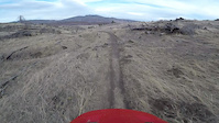
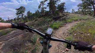
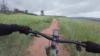
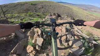
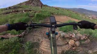
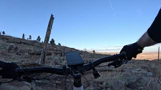
Photos of Bobcat Ridge Mountain Bike
Videos of Bobcat Ridge Mountain Bike
trail: Ginny
0:51 |
1077 |
Feb 20, 2017
trail: DR Trail
18:50 |
80 |
Aug 7, 2025 , Loveland
trail: Valley Loop
13:21 |
36 |
Aug 6, 2025 , Loveland
trail: Ginny
16:02 |
126 |
Jul 30, 2025 , Loveland
trail: Ginny
30:54 |
68 |
Jul 30, 2025 , Loveland
trail: Ginny
6:57 |
163 |
Apr 4, 2024 , Loveland

trail: On the Rocks
3:38 |
538 |
Sep 5, 2022 , Loveland

Recent Trail Reports
| status | trail | date | condition | info | user |
|---|---|---|---|---|---|
| DR Trail | Apr 2, 2026 @ 8:58am (America/Denver) Apr 2, 2026 | Dry | Zacktivist | ||
| Ginny | Apr 2, 2026 @ 8:58am (America/Denver) Apr 2, 2026 | Dry | Zacktivist | ||
| Valley Loop | Oct 2, 2023 @ 9:26am Oct 2, 2023 | Dry | hddhmuysbm | ||
| Eden Valley Spur | Sep 8, 2023 @ 10:46am Sep 8, 2023 | Dry | zoeshark | ||
| Valley Loop (accessible Grade) | Sep 8, 2023 @ 10:46am Sep 8, 2023 | Dry | zoeshark | ||
| Bobcat Ridge | Sep 8, 2023 @ 10:46am Sep 8, 2023 | Dry | zoeshark | ||
| Power Line Trail | Sep 8, 2023 @ 10:46am Sep 8, 2023 | Dry | zoeshark | ||
| On the Rocks | Sep 8, 2023 @ 10:46am Sep 8, 2023 | Dry | zoeshark | ||
| Powerline Road | Sep 8, 2023 @ 10:46am Sep 8, 2023 | Dry | zoeshark |
Activity Feed
| username | action | type | title | date |
|---|---|---|---|---|
| Jacob8Fuv5q | difficultyvote | trail | activity #96189698 | Jun 3, 2026 @ 4:44pm Jun 3, 2026 |
| Studjqyhawk | ridden | trail | activity #95411886 | May 24, 2026 @ 8:16am May 24, 2026 |
| mostbeast | wishlist | region | activity #94627886 | May 13, 2026 @ 8:06am May 13, 2026 |
| Spencer0416 | wishlist | trail | activity #92918839 | Apr 18, 2026 @ 9:09pm Apr 18, 2026 |
| James8nHaN1 | wishlist | route | activity #92607802 | Apr 14, 2026 @ 10:41am Apr 14, 2026 |
Recent Comments
| username | type | title | comment | date |
|---|---|---|---|---|
| trail | A roller coaster (read: pedaly) of a trail. At... | Oct 6, 2024 @ 2:40pm Oct 6, 2024 | ||
| trail | Really cool trail at first when I saw the... | Oct 3, 2024 @ 12:51pm Oct 3, 2024 | ||
| trail | All of bobcat is closed due to a fire | Aug 15, 2024 @ 3:05pm Aug 15, 2024 | ||
| trail | I rode this 10 years ago on a 90's hardtail... | May 27, 2024 @ 4:02pm May 27, 2024 | ||
| trail | Rode this Memorial Day 2024. Still posted as... | May 27, 2024 @ 3:30pm May 27, 2024 |
Nearby Areas
| name | distance | ||||
|---|---|---|---|---|---|
| Coyote Ridge | 6 | 1 | 4.9 km | ||
| Devils Backbone Open Space | 2 | 2 | 2 | 5.5 km | |
| Horsetooth Mountain | 10 | 8 | 10 | 6.2 km | |
| Prairie Ridge Natural Area | 6.5 km | ||||
| Lory State Park | 3 | 8 | 3 | 7.4 km |
Local Products
Activity Type Stats
| activitytype | trails | distance | descent | descent distance | total vertical | rating | global rank | state rank | photos | reports | routes | ridelogs |
|---|---|---|---|---|---|---|---|---|---|---|---|---|
| Mountain Bike | 14 | 19 miles | 3,363 ft | 7 miles | 1,565 ft | #5,438 | #1,971 | 79 | 321 | 1 | 3,128 | |
| Horse | 3 | 3 miles | 98 ft | 1,946 ft | 948 ft | 29 | ||||||
| Hike | 14 | 19 miles | 3,363 ft | 7 miles | 1,565 ft | #9,025 | #3,419 | 321 | 79 | |||
| Trail Running | 14 | 19 miles | 3,363 ft | 7 miles | 1,565 ft | #8,183 | #2,839 | 321 | 80 |
Frequently Asked Questions About Bobcat Ridge
▼
What are the highest rated mountain biking trails in Bobcat Ridge?
The highest rated mountain biking trails in Bobcat Ridge are:
- DR Trail (4.1/5)
- Ginny (4.1/5)
- On the Rocks (4/5)
- Eden Valley Spur (4/5)
- Valley Loop (4/5)
▼
What is the best time of the year to ride in Bobcat Ridge?
Based on ride log data, the most popular months to ride in Bobcat Ridge are:
- July (22 activities)
- October (22 activities)
- June (14 activities)
▼
Where can I park to ride in Bobcat Ridge?
Check the Bobcat Ridge trail map for trailhead and parking information. Community members regularly update access and parking details for trails in the area.
▼
What is the longest trail in Bobcat Ridge?
The longest trail in Bobcat Ridge is Ginny at 5.3 miles. View all trails sorted by distance.
- By todd
 Trailforks & contributors
 - Admins: OMBA, OMBATrailAgent
- #4945 - 9,365 views
- bobcat ridge activity log | embed map of Bobcat Ridge mountain bike trails |
Downloading of trail gps tracks in kml & gpx formats is enabled for Bobcat Ridge.
You must login to download files.