close
-
Layers w
- Weather Layers
- Pro
- Pro
- Pro
- Pro
- Pro
- Pro
- More Layers
- Pro
- Pro
- Pro
- Pro
-
Upgrade to

3D
Trail Conditions
- Unknown
- Snow Groomed
- Snow Packed
- Snow Covered
- Snow Cover Partial
- Freeze/thaw Cycle
- Icy
- Prevalent Mud
- Wet
- Variable
- Ideal
- Dry
- Very Dry
Trail Flow (Ridden Direction)
Trailforks scans users ridelogs to determine the most popular direction each trail is ridden. A good flowing trail network will have most trails flowing in a single direction according to their intension.
The colour categories are based on what percentage of riders are riding a trail in its intended direction.
The colour categories are based on what percentage of riders are riding a trail in its intended direction.
- > 96%
- > 90%
- > 80%
- > 70%
- > 50%
- < 50%
- bi-directional trail
- no data
Trail Last Ridden
Trailforks scans ridelogs to determine the last time a trail was ridden.
- < 2 days
- < 1 week
- < 2 weeks
- < 1 month
- < 6 months
- > 6 months
Trail Ridden Direction
The intended direction a trail should be ridden.
- Downhill Only
- Downhill Primary
- Both Directions
- Uphill Primary
- Uphill Only
- One Direction
Contribute Details
Colors indicate trail is missing specified detail.
- Description
- Photos
- Description & Photos
- Videos
Trail Popularity ?
Trailforks scans ridelogs to determine which trails are ridden the most in the last 9 months.
Trails are compared with nearby trails in the same city region with a possible 25 colour shades.
Think of this as a heatmap, more rides = more kinetic energy = warmer colors.
- most popular
- popular
- less popular
- not popular
ATV/ORV/OHV Filter
Max Vehicle Width
inches
US Cell Coverage
Legend

Radar Time
Activity Recordings
Trailforks uses anonymized public activity data.
?
Activity Recordings
Trailforks uses anonymized public activity data.
?
Personal Heatmap
▶
Activity Types
all
/
none
▶
Options
2
Date range
month
–
Winter Trails
Warning
A routing network for winter maps does not exist. Selecting trails using the winter trails layer has been disabled.
Missing Trails
Most Popular
Least Popular
Trails are colored based on popularity. The more popular a trail is, the more red. Less popular trails trend towards green.
Jump Magnitude Heatmap
Heatmap of where riders jump on trails. Zoom in to see individual jumps, click circles to view jump details.
BC Backroad Status
![map legend]()
Service Road Atlas is a free to use, community-driven service for viewing and creating reports on the numerous back-country service roads around B.C. and Alberta.

Slope Aspect
Direction the slope faces
Trails Deemphasized
Trails are shown in grey.
Only show trails with no bike usage.
Suggested Layers
Based on selected activity type
Save the current map location and zoom level as your default home location whenever this page is loaded.
Save
No description for Bodmin has been added yet!
Login or register to submit one.
This region uses the Uk/Euro style trail grading system.
Activities Click to view
- Mountain Bike
66 trails
- E-Bike
15 trails
- Winter Fat Bike
0 trails
- Horse
7 trails
- Hike
65 trails
- Trail Running
65 trails
Region Details
- 11
- 1
- 31
- 15
- 7
Region Status
Open as of Jun 22, 2026Stats
- Avg Trail Rating
- Trails (view details)
- 66
- Trails Mountain Bike
- 66
- Trails E-Bike
- 15
- Trails Horse
- 7
- Trails Hike
- 65
- Trails Trail Running
- 65
- Total Distance
- 30 miles
- Total Descent
- 7,827 ft
- Total Vertical
- 483 ft
- Highest Trailhead
- 559 ft
- Reports
- 273
- Photos
- 50
- Ridden Counter
- 7,738
Sub Regions
-
"GBH"
- 3
- 1
-
Cardinham Woods
- 2
- 1
-
Lanhydrock Woods
- 1
- 4
- 1
Popular Bodmin Mountain Biking Trails
• 100 ★ 4.4 • 2,945 ft • 19 ft • 391 •
Popular blue difficulty singletrack. This mountain bike primary trail can be used one direction. On average it takes 3 minutes to complete this trail.
• 100 ★ 4.4 • 1 mile • 164 ft • 388 •
Popular blue difficulty singletrack. This mountain bike primary trail can be used one direction. On average it takes 12 minutes to complete this trail.
• 100 ★ 4.0 • 1 mile • 204 ft • 388 •
Popular blue difficulty singletrack. This mountain bike primary trail can be used one direction. On average it takes 13 minutes to complete this trail.
• 95 ★ 4.0 • 1,080 ft • 21 ft • 367 •
Popular blue difficulty singletrack. This mountain bike primary trail can be used one direction. On average it takes minutes to complete this trail.
• 95 ★ 4.4 • 1,373 ft • 86 ft • 363 •
Popular blue difficulty singletrack. This mountain bike primary trail can be used one direction. On average it takes 2 minutes to complete this trail.
• 95 ★ 3.9 • 1 mile • 270 ft • 349 •
Good all weather trail centre, forestry commission site. Some tight switchbacks that are poorly designed but some great flow sections. Park at Cardinham and follow the signposted route. Cafè on site too
• 85 ★ 4.4 • 4,197 ft • 205 ft • 281 •
Hell’s teeth, it’s steep! After a tough climb, with some very steep sections, you’ll be rewarded at the top with some narrow, flowing trail featuring numerous technical features. The trail ends with a steep, bermed descent back...
• 80 ★ 4.5 • 3,580 ft • 7 ft • 239 •
The is one of the blue trails in Lanhydrock Woods, it is mostly downhill, but does have two short uphill sections which help to break it up a little. The tail starts near the start of and Heart Trails and is well sign posted (as all...
Bodmin Mountain Bike Routes
★ 4.5 • 12 miles • 488 ft • 0 • Point to Point •
Family trail along the disused Camel railway line
8 miles • 1,121 ft • 8 • Loop •
Nice little ride out around the woods (y)
★ 3.0 • 7 miles • 68 ft • 0 • Loop •
This super Cornish trail is suitable for both walkers and cyclists and takes you on a tour of the 480...
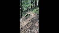
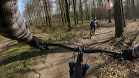
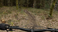
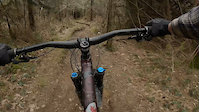
Photos of Bodmin Mountain Bike
Videos of Bodmin Mountain Bike
trail: Wizard Stick
0:10 |
116 |
Jan 3, 2023
trail: Grogley DH link
2:28 |
210 |
May 9, 2021
trail: Grogley DH link
0:42 |
74 |
Mar 30, 2021
trail: Grogley DH link
0:37 |
84 |
Mar 30, 2021

trail: Grogley DH Middle Line
0:50 |
260 |
Feb 24, 2020

trail: Bishops Finger
0:14 |
296 |
Apr 6, 2017
trail: Quarry Tipper
3:14 |
935 |
Mar 21, 2015

trail: Range
3:32 |
1653 |
May 10, 2013
Recent Trail Reports
| status | trail | date | condition | info | user |
|---|---|---|---|---|---|
| Target | Mar 27, 2026 @ 5:54pm (Europe/London) Mar 27, 2026 | Ideal | ripsilver Cornwall | ||
| The Rabbit Hole | Oct 26, 2025 @ 3:51pm (Europe/London) Oct 26, 2025 | Ideal | ripsilver Cornwall | ||
| Root Canal | Oct 26, 2025 @ 3:51pm (Europe/London) Oct 26, 2025 | Ideal | ripsilver Cornwall | ||
| Thor | Oct 26, 2025 @ 3:45pm (Europe/London) Oct 26, 2025 | Ideal | ripsilver Cornwall | ||
| Quarry Tipper | Oct 26, 2025 @ 3:44pm (Europe/London) Oct 26, 2025 | Ideal | ripsilver Cornwall | ||
| Grogley DH link | Oct 26, 2025 @ 3:44pm (Europe/London) Oct 26, 2025 | Ideal | ripsilver Cornwall | ||
| Grogley DH Middle Line | Oct 26, 2025 @ 3:41pm (Europe/London) Oct 26, 2025 | Ideal | ripsilver Cornwall | ||
| Bazley's Trail | Aug 21, 2025 @ 3:29am Aug 21, 2025 | Unknown | CodyVjZVRm | ||
| Wizard Stick | Aug 1, 2025 @ 1:32pm Aug 1, 2025 | Dry | ripsilver Cornwall | ||
| Rattler | Aug 1, 2025 @ 1:29pm Aug 1, 2025 | Dry | ripsilver Cornwall |
Activity Feed
| username | action | type | title | date |
|---|---|---|---|---|
| wonkle | vote | trail | activity #96525799 | Jun 8, 2026 @ 1:05am Jun 8, 2026 |
| wonkle | ridden | trail | activity #96439830 | Jun 7, 2026 @ 2:49am Jun 7, 2026 |
| wonkle | ridden | trail | activity #96437611 and 5 more | Jun 7, 2026 @ 2:05am Jun 7, 2026 |
| ripsilver | add | report | activity #91384747 | Mar 27, 2026 @ 10:54am Mar 27, 2026 |
| ripsilver | vote | trail | activity #91384611 | Mar 27, 2026 @ 10:52am Mar 27, 2026 |
Recent Comments
| username | type | title | comment | date |
|---|---|---|---|---|
| trail | Fun wee trail! | May 16, 2023 @ 7:28am May 16, 2023 | ||
| trail | Fun turns towards the bottom, probably one of... | May 16, 2023 @ 7:27am May 16, 2023 | ||
| trail | Couldn’t find the top part so use the... | May 16, 2023 @ 7:27am May 16, 2023 | ||
| trail | Couldn’t find the top part, and the bottom... | May 16, 2023 @ 7:26am May 16, 2023 | ||
| trail | Definitely not a blue trail, slippy adverse... | Jan 24, 2023 @ 8:20am Jan 24, 2023 |
Local Badges
-

Epic Ride Climb 2k30 awarded -

Climbing 10k Badge36 awarded -

Climbing 100k Badge4 awarded -

Epic Ride Descent 2k29 awarded -

Descent 10k Badge37 awarded -

Descent 100k Badge5 awarded
Bike & Skill Parks
| name | type | city | rating |
|---|---|---|---|
| Lanhydrock skills area/pump track. | skill park | Bodmin |
Activity Type Stats
| activitytype | trails | distance | descent | descent distance | total vertical | rating | global rank | state rank | photos | reports | routes | ridelogs |
|---|---|---|---|---|---|---|---|---|---|---|---|---|
| Mountain Bike | 66 | 30 miles | 7,657 ft | 19 miles | 482 ft | #1,989 | #66 | 50 | 273 | 4 | 8,806 | |
| E-Bike | 15 | 7 miles | 932 ft | 4 miles | 453 ft | #3,741 | #138 | 214 | 1 | 1,188 | ||
| Horse | 7 | 5 miles | 531 ft | 2 miles | 364 ft | #1,068 | #50 | 73 | ||||
| Hike | 65 | 30 miles | 7,762 ft | 19 miles | 482 ft | #4,318 | #99 | 272 | 359 | |||
| Trail Running | 65 | 30 miles | 7,762 ft | 19 miles | 482 ft | #3,752 | #87 | 272 | 82 |
Frequently Asked Questions About Bodmin
▼
What are the best places to ride in Bodmin?
Bodmin has 3 areas to explore for mountain biking. The top rated areas are:
▼
What are the highest rated mountain biking trails in Bodmin?
The highest rated mountain biking trails in Bodmin are:
- Wizard Stick (4.3/5)
- The Rabbit Hole (4.2/5)
- Timber Trail (4.2/5)
- The Cribbar (4.2/5)
- The Whip (4.2/5)
▼
What is the best time of the year to ride in Bodmin?
Based on ride log data, the most popular months to ride in Bodmin are:
- June (56 activities)
- August (53 activities)
- July (53 activities)
▼
Where can I park to ride in Bodmin?
There are 3 parking locations listed in Bodmin. The most popular parking spots are: View all parking and trailhead locations on the map to plan your visit.
Activities
- By Schism14 & contributors
- Admins: wisey, MathieuC, cemoorelife, Cornwall
- #5664 - 11,064 views
- bodmin activity log | embed map of Bodmin mountain bike trails | bodmin mountain biking points of interest
Downloading of trail gps tracks in kml & gpx formats is enabled for Bodmin.
You must login to download files.