close
-
Layers w
- Weather Layers
- Pro
- Pro
- Pro
- Pro
- Pro
- Pro
- More Layers
- Pro
- Pro
- Pro
- Pro
-
Upgrade to

3D
Trail Conditions
- Unknown
- Snow Groomed
- Snow Packed
- Snow Covered
- Snow Cover Partial
- Freeze/thaw Cycle
- Icy
- Prevalent Mud
- Wet
- Variable
- Ideal
- Dry
- Very Dry
Trail Flow (Ridden Direction)
Trailforks scans users ridelogs to determine the most popular direction each trail is ridden. A good flowing trail network will have most trails flowing in a single direction according to their intension.
The colour categories are based on what percentage of riders are riding a trail in its intended direction.
The colour categories are based on what percentage of riders are riding a trail in its intended direction.
- > 96%
- > 90%
- > 80%
- > 70%
- > 50%
- < 50%
- bi-directional trail
- no data
Trail Last Ridden
Trailforks scans ridelogs to determine the last time a trail was ridden.
- < 2 days
- < 1 week
- < 2 weeks
- < 1 month
- < 6 months
- > 6 months
Trail Ridden Direction
The intended direction a trail should be ridden.
- Downhill Only
- Downhill Primary
- Both Directions
- Uphill Primary
- Uphill Only
- One Direction
Contribute Details
Colors indicate trail is missing specified detail.
- Description
- Photos
- Description & Photos
- Videos
Trail Popularity ?
Trailforks scans ridelogs to determine which trails are ridden the most in the last 9 months.
Trails are compared with nearby trails in the same city region with a possible 25 colour shades.
Think of this as a heatmap, more rides = more kinetic energy = warmer colors.
- most popular
- popular
- less popular
- not popular
ATV/ORV/OHV Filter
Max Vehicle Width
inches
US Cell Coverage
Legend

Radar Time
Activity Recordings
Trailforks uses anonymized public activity data.
?
Activity Recordings
Trailforks uses anonymized public activity data.
?
Personal Heatmap
▶
Activity Types
all
/
none
▶
Options
2
Date range
month
–
Winter Trails
Warning
A routing network for winter maps does not exist. Selecting trails using the winter trails layer has been disabled.
Missing Trails
Most Popular
Least Popular
Trails are colored based on popularity. The more popular a trail is, the more red. Less popular trails trend towards green.
Jump Magnitude Heatmap
Heatmap of where riders jump on trails. Zoom in to see individual jumps, click circles to view jump details.
BC Backroad Status
![map legend]()
Service Road Atlas is a free to use, community-driven service for viewing and creating reports on the numerous back-country service roads around B.C. and Alberta.

Slope Aspect
Direction the slope faces
Trails Deemphasized
Trails are shown in grey.
Only show trails with no bike usage.
Suggested Layers
Based on selected activity type
Save the current map location and zoom level as your default home location whenever this page is loaded.
Save
No description for Bolivia has been added yet!
Login or register to submit one.
Region Details
- 2
- 22
- 17
- 2
Stats
- Avg Trail Rating
- Trails (view details)
- 43
- Trails Mountain Bike
- 43
- Trails E-Bike
- 19
- Trails Horse
- 1
- Trails Hike
- 66
- Trails Trail Running
- 63
- Trails Snowshoe
- 2
- Total Distance
- 160 miles
- Total Descent
- 96,210 ft
- Total Vertical
- 11,497 ft
- Highest Trailhead
- 15,447 ft
- Reports
- 17
- Photos
- 95
- Ridden Counter
- 798
Articles
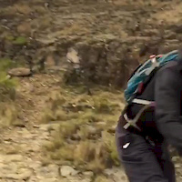
Video: Mountain Biking in Bolivia with Miranda Miller & Meeting the Trail Building Cholitas
Aug 14, 2024 from pinkbike.com
The trails at the Ñuñumayani trail center are managed, built and maintained by a group of Indigenous Bolivian women, respectfully known as Cholitas.
Video: Hannah Bergemann & Friends Riding Endless Scree Runs in Bolivia
Oct 5, 2023 from pinkbike.com
Dropping!
Sub Regions
- La Paz (0)
- Manco Kapac (0)
- Manco Kapac (0)
- La Paz (14)
- Sorata (3)
- Tarija (22)
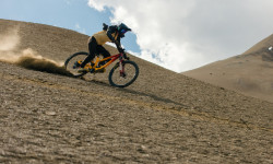
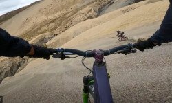
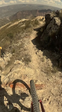
Popular Bolivia Mountain Biking Trails
• 100 ★ 4.4 • 18 miles • 7,210 ft • 124 •
Nor Yungas Road, aka , aka the Death Road. Drive on the left!
• 100 ★ 4.0 • 9 miles • 843 ft • 13 •
Trails follows the main ridge into the town of Sorata. Some small up hills and there are some exposed section. Good intro to some of the biking in the Sorata area.
• 5 ★ 0.0 • 6 miles • 1,812 ft • 8 •
Ride the road up to the Muela del Diablo, Take the lower road around the base of the Muela Del Diablo. Near the end of the road starts the single trail. Follow this down to the river. There is only one trial.
• 5 ★ 0.0 • 7 miles • 830 ft • 5 •
Single trail used by the local people. Great easy ride in the area with views of Mt Illimani (6439m)
• 5 ★ 3.0 • 5 miles • 360 ft • 3 •
Single track, starting at 4000m down to the village of Sorata. Very nice flowing trail through different vegetation. Some steep sections in places.
• 95 ★ 0.0 • 3 miles • 131 ft • 3 •
Good trail close to La Paz. Has a mix of riding, small jumps and steep sections. The groud is loss and slippery with lots of small stones.
Bolivia Mountain Bike Routes
32 miles • 5,657 ft • 0 • Out & Back •
Clim and descent to Chojo. Start pain is Huajchilla/Taypichullo.
• 20 miles • 6,694 ft • 1 •
• 13 miles • 589 ft • 0 •
Photos of Bolivia Mountain Bike
Videos of Bolivia Mountain Bike
trail: La Termita
4:38 |
46 |
May 24, 2024
trail: El Chucho Trail
0:09 |
21 |
Oct 24, 2018

trail: Supertrail Bolivia
1279 |
Jul 28, 2015 , La Paz
Recent Comments
| username | type | title | comment | date |
|---|---|---|---|---|
| trail | My favourite trail in Sorata. 3 A loooooong... | Dec 17, 2022 @ 5:12am Dec 17, 2022 | ||
| trail | rock garden | Dec 10, 2020 @ 6:59am Dec 10, 2020 | ||
| trail | Ascent: No technical difficulty, the roads... | Feb 1, 2019 @ 2:47pm Feb 1, 2019 |
Activity Type Stats
| activitytype | trails | distance | descent | descent distance | total vertical | rating | global rank | state rank | photos | reports | routes | ridelogs |
|---|---|---|---|---|---|---|---|---|---|---|---|---|
| Mountain Bike | 43 | 160 miles | 96,211 ft | 116 miles | 11,496 ft | #70 | 95 | 17 | 1 | 7,730 | ||
| E-Bike | 19 | 84 miles | 41,870 ft | 60 miles | 9,196 ft | #58 | 17 | 62 | ||||
| Horse | 1 | 1,713 ft | 89 ft | 1,293 ft | 82 ft | #86 | 1 | |||||
| Hike | 66 | 154 miles | 91,896 ft | 112 miles | 11,496 ft | #67 | 17 | 1,331 | ||||
| Trail Running | 63 | 141 miles | 84,114 ft | 102 miles | 11,496 ft | #65 | 17 | 20 | ||||
| Snowshoe | 2 | #36 |
Activities
Trails
Points of Interest
- By canadaka
 Trailforks & contributors
 - Admins: apply
- #3265 - 8,329 views
- bolivia activity log | embed map of Bolivia mountain bike trails | bolivia mountain biking points of interest
Downloading of trail gps tracks in kml & gpx formats is enabled for Bolivia.
You must login to download files.