close
-
Layers w
- Weather Layers
- Pro
- Pro
- Pro
- Pro
- Pro
- Pro
- More Layers
- Pro
- Pro
- Pro
- Pro
-
Upgrade to

3D
Trail Conditions
- Unknown
- Snow Groomed
- Snow Packed
- Snow Covered
- Snow Cover Partial
- Freeze/thaw Cycle
- Icy
- Prevalent Mud
- Wet
- Variable
- Ideal
- Dry
- Very Dry
Trail Flow (Ridden Direction)
Trailforks scans users ridelogs to determine the most popular direction each trail is ridden. A good flowing trail network will have most trails flowing in a single direction according to their intension.
The colour categories are based on what percentage of riders are riding a trail in its intended direction.
The colour categories are based on what percentage of riders are riding a trail in its intended direction.
- > 96%
- > 90%
- > 80%
- > 70%
- > 50%
- < 50%
- bi-directional trail
- no data
Trail Last Ridden
Trailforks scans ridelogs to determine the last time a trail was ridden.
- < 2 days
- < 1 week
- < 2 weeks
- < 1 month
- < 6 months
- > 6 months
Trail Ridden Direction
The intended direction a trail should be ridden.
- Downhill Only
- Downhill Primary
- Both Directions
- Uphill Primary
- Uphill Only
- One Direction
Contribute Details
Colors indicate trail is missing specified detail.
- Description
- Photos
- Description & Photos
- Videos
Trail Popularity ?
Trailforks scans ridelogs to determine which trails are ridden the most in the last 9 months.
Trails are compared with nearby trails in the same city region with a possible 25 colour shades.
Think of this as a heatmap, more rides = more kinetic energy = warmer colors.
- most popular
- popular
- less popular
- not popular
ATV/ORV/OHV Filter
Max Vehicle Width
inches
US Cell Coverage
Legend

Radar Time
Activity Recordings
Trailforks uses anonymized public activity data.
?
Activity Recordings
Trailforks uses anonymized public activity data.
?
Personal Heatmap
▶
Activity Types
all
/
none
▶
Options
2
Date range
month
–
Winter Trails
Warning
A routing network for winter maps does not exist. Selecting trails using the winter trails layer has been disabled.
Missing Trails
Most Popular
Least Popular
Trails are colored based on popularity. The more popular a trail is, the more red. Less popular trails trend towards green.
Jump Magnitude Heatmap
Heatmap of where riders jump on trails. Zoom in to see individual jumps, click circles to view jump details.
BC Backroad Status
![map legend]()
Service Road Atlas is a free to use, community-driven service for viewing and creating reports on the numerous back-country service roads around B.C. and Alberta.

Slope Aspect
Direction the slope faces
Trails Deemphasized
Trails are shown in grey.
Only show trails with no bike usage.
Suggested Layers
Based on selected activity type
Save the current map location and zoom level as your default home location whenever this page is loaded.
Save
No description for Bologna has been added yet!
Login or register to submit one.
This region uses the Uk/Euro style trail grading system.
Activities Click to view
- Mountain Bike
101 trails
- E-Bike
61 trails
- Gravel Bike
0 trails
- Adaptive Bike
0 trails
- Winter Fat Bike
0 trails
- Horse
7 trails
- Hike
88 trails
- Trail Running
88 trails
Region Details
- 16
- 5
- 46
- 20
Region Status
Open as of 2 daysStats
- Avg Trail Rating
- Trails (view details)
- 89
- Trails Mountain Bike
- 101
- Trails E-Bike
- 61
- Trails Horse
- 7
- Trails Hike
- 88
- Trails Trail Running
- 88
- Total Distance
- 73 miles
- Total Descent
- 27,623 ft
- Total Vertical
- 4,377 ft
- Highest Trailhead
- 4,508 ft
- Reports
- 1,909
- Photos
- 43
- Ridden Counter
- 4,285
Sub Regions
-
Bregoli
- 11
- 2
-
Gessi Bolognesi
- 18
- 4
-
Monte Sole
- 2
- 4
-
Monzuno / Monte Venere
- 3
- 2
-
Zola Predosa
- 5
- 9
- 3
Popular Bologna Mountain Biking Trails
• 100 ★ 4.5 • 1,119 ft • 0 ft • 111 •
Popular blue difficulty singletrack. This mountain bike primary trail can be used downhill only and has a moderate overall physical rating. Trail visibility is always easy to follow.
• 100 ★ 4.3 • 681 ft • 69 ft • 94 •
Popular blue difficulty singletrack. This mountain bike primary trail can be used downhill primary. On average it takes minutes to complete this trail.
• 55 ★ 4.7 • 1 mile • 110 ft • 92 •
Highly rated moderately popular red difficulty singletrack. This mountain bike primary trail can be used downhill only. It features rock face and skinny. Trail visibility is always easy to follow. On average it takes 8 minutes to complete this trail.
• 90 ★ 4.7 • 4,134 ft • 56 ft • 92 •
Highly rated popular blue difficulty singletrack. This mountain bike primary trail can be used downhill only. On average it takes 8 minutes to complete this trail.
• 95 ★ 4.2 • 2,890 ft • 110 ft • 86 •
Popular green difficulty singletrack. This mountain bike primary trail can be used both directions and has a easy overall physical rating with a 110 ft green climb. On average it takes 6 minutes to complete this trail.
• 90 ★ 4.0 • 3,965 ft • 198 ft • 66 •
Popular blue difficulty singletrack. This mountain bike primary trail can be used downhill primary. On average it takes 6 minutes to complete this trail.
• 85 ★ 3.6 • 1 mile • 96 ft • 66 •
Popular green difficulty singletrack. This mountain bike primary trail can be used both directions and has a easy overall physical rating with a 96 ft green climb. It features rock face and rock garden. On average it takes 10 minutes to complete this trail.
• 80 ★ 5.0 • 846 ft • 0 ft • 65 •
Popular blue difficulty wilderness trail. This mountain bike primary trail can be used downhill only. On average it takes 1 minutes to complete this trail.
Bologna Mountain Bike Routes
★ 4.0 • 73 miles • 9,165 ft • 1 • Point to Point •
Sul crinale tra Setta e Savena, gli Etruschi percorsero per almeno 4 secoli (VII-IV sec. a.C.) un’antica...
★ 5.0 • 30 miles • 3,750 ft • 3 •
Anello Valle del Lavino - Val Samoggia - Valle del Lavino
31 miles • 2,758 ft • 0 • Loop •
..........................................................................
2 miles • 536 ft • 0 •
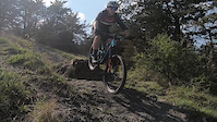
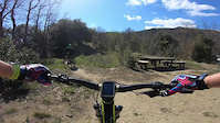
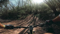
Photos of Bologna Mountain Bike
Videos of Bologna Mountain Bike
trail: Saetta
0:11 |
17 |
Oct 26, 2025
trail: Zenarella Bis
5:40 |
19 |
Mar 26, 2023
trail: Casa Fantini
4:49 |
19 |
Mar 26, 2023

trail: Dulcamara
2:26 |
22 |
Oct 13, 2022
trail: 100
3:54 |
10989 |
Mar 13, 2018
trail: La Nuova
15:39 |
311 |
Jun 24, 2014

trail: Media
0:48 |
225 |
Sep 14, 2013
trail: Media
3:51 |
6147 |
May 20, 2013
Recent Trail Reports
| status | trail | date | condition | info | user |
|---|---|---|---|---|---|
| Ciclabile #1 Ozzano - Monterenzio | Jun 17, 2026 @ 4:58pm (Europe/San_Marino) 2 days | Ideal | gpaoloconti | ||
| Boschetto Piombarola | Jun 17, 2026 @ 4:58pm (Europe/San_Marino) 2 days | Ideal | gpaoloconti | ||
| Gaibola Est | Jun 14, 2026 @ 9:15am (Europe/Rome) Jun 14, 2026 | Ideal | pigiguidi | ||
| Trail del Macaco | Jun 14, 2026 @ 9:15am (Europe/Rome) Jun 14, 2026 | Ideal | pigiguidi | ||
| Casa Fantini | Jun 14, 2026 @ 9:15am (Europe/Rome) Jun 14, 2026 | Ideal | pigiguidi | ||
| Sboccata dei Bagnadori | Jun 12, 2026 @ 9:57am (Europe/San_Marino) Jun 12, 2026 | Ideal | gab-pulga | ||
| Gaibola | Jun 10, 2026 @ 5:07pm (Europe/San_Marino) Jun 10, 2026 | Ideal | gpaoloconti | ||
| Croara | May 28, 2026 @ 7:34pm (Europe/Rome) May 28, 2026 | Dry | alessandrozacheo | ||
| Montecalvo chiesa | May 28, 2026 @ 7:34pm (Europe/Rome) May 28, 2026 | Dry | alessandrozacheo | ||
| Saetta | May 25, 2026 @ 7:53am (Europe/San_Marino) May 24, 2026 | Ideal | gpaoloconti |
Activity Feed
| username | action | type | title | date |
|---|---|---|---|---|
| gpaoloconti | add | report | activity #97205861 and 1 more | Jun 17, 2026 @ 1:15pm 2 days |
| pigiguidi | add | report | activity #96961249 and 1 more | Jun 14, 2026 @ 6:18am Jun 14, 2026 |
| pigiguidi | add | report | activity #96961248 | Jun 14, 2026 @ 6:18am Jun 14, 2026 |
| gab-pulga | add | report | activity #96826948 | Jun 12, 2026 @ 2:04pm Jun 12, 2026 |
| gpaoloconti | add | report | activity #96693520 | Jun 10, 2026 @ 1:32pm Jun 10, 2026 |
Recent Comments
| username | type | title | comment | date |
|---|---|---|---|---|
| trail | Super nice Trail:) ...but definitely not... | May 4, 2025 @ 7:04am May 4, 2025 | ||
| trail | Bel trail guidato, un ripidone all' inizio... | Apr 19, 2025 @ 12:25pm Apr 19, 2025 | ||
| trail | Livello S2/S3 con un passaggio finale... | Feb 3, 2025 @ 12:52am Feb 3, 2025 | ||
| report | Poco fango | Mar 23, 2024 @ 10:46am Mar 23, 2024 | ||
| report | Fattibile con poco fango | Mar 23, 2024 @ 10:43am Mar 23, 2024 |
Local Badges
-

10 Green Trails74 awarded -

Epic Ride Climb 2k365 awarded -

Climbing 10k Badge101 awarded -

Climbing 100k Badge22 awarded -

Epic Ride Descent 2k363 awarded -

Descent 10k Badge100 awarded
Bike & Skill Parks
| name | type | city | rating |
|---|---|---|---|
| Pinewood Indoor Bike Park | skill park | Bologna |
Activity Type Stats
| activitytype | trails | distance | descent | descent distance | total vertical | rating | global rank | state rank | photos | reports | routes | ridelogs |
|---|---|---|---|---|---|---|---|---|---|---|---|---|
| Mountain Bike | 101 | 73 miles | 27,625 ft | 43 miles | 4,377 ft | #1,405 | #41 | 43 | 1,909 | 6 | 19,139 | |
| E-Bike | 61 | 36 miles | 12,595 ft | 22 miles | 2,959 ft | #2,313 | #222 | 1,858 | 1 | 2,433 | ||
| Horse | 7 | 3 miles | 899 ft | 2 miles | 751 ft | #886 | #26 | 43 | 1 | |||
| Hike | 88 | 65 miles | 24,770 ft | 39 miles | 4,377 ft | #2,618 | #85 | 1,903 | 1 | 316 | ||
| Trail Running | 88 | 65 miles | 24,787 ft | 39 miles | 4,377 ft | #2,122 | #64 | 1,903 | 1 | 208 |
Frequently Asked Questions About Bologna
▼
What are the best places to ride in Bologna?
Bologna has 5 areas to explore for mountain biking. The top rated areas are:
▼
What are the highest rated mountain biking trails in Bologna?
The highest rated mountain biking trails in Bologna are:
- Casa Fantini (4.4/5)
- Saetta (4.3/5)
- Biondina (4.3/5)
- Trail del Macaco (4.3/5)
- Paolona Dh (4.3/5)
▼
What is the best time of the year to ride in Bologna?
Based on ride log data, the most popular months to ride in Bologna are:
- May (113 activities)
- July (111 activities)
- September (110 activities)
▼
Where can I park to ride in Bologna?
There are 1 parking locations listed in Bologna. The most popular parking spots are:
Activities
Trails
- By AndrewMK
 & contributors
 - Admins: apply
- #6556 - 14,164 views
- bologna activity log | embed map of Bologna mountain bike trails | bologna mountain biking points of interest
Downloading of trail gps tracks in kml & gpx formats is enabled for Bologna.
You must login to download files.