close
-
Layers w
- Weather Layers
- Pro
- Pro
- Pro
- Pro
- Pro
- Pro
- More Layers
- Pro
- Pro
- Pro
- Pro
-
Upgrade to

3D
Trail Conditions
- Unknown
- Snow Groomed
- Snow Packed
- Snow Covered
- Snow Cover Partial
- Freeze/thaw Cycle
- Icy
- Prevalent Mud
- Wet
- Variable
- Ideal
- Dry
- Very Dry
Trail Flow (Ridden Direction)
Trailforks scans users ridelogs to determine the most popular direction each trail is ridden. A good flowing trail network will have most trails flowing in a single direction according to their intension.
The colour categories are based on what percentage of riders are riding a trail in its intended direction.
The colour categories are based on what percentage of riders are riding a trail in its intended direction.
- > 96%
- > 90%
- > 80%
- > 70%
- > 50%
- < 50%
- bi-directional trail
- no data
Trail Last Ridden
Trailforks scans ridelogs to determine the last time a trail was ridden.
- < 2 days
- < 1 week
- < 2 weeks
- < 1 month
- < 6 months
- > 6 months
Trail Ridden Direction
The intended direction a trail should be ridden.
- Downhill Only
- Downhill Primary
- Both Directions
- Uphill Primary
- Uphill Only
- One Direction
Contribute Details
Colors indicate trail is missing specified detail.
- Description
- Photos
- Description & Photos
- Videos
Trail Popularity ?
Trailforks scans ridelogs to determine which trails are ridden the most in the last 9 months.
Trails are compared with nearby trails in the same city region with a possible 25 colour shades.
Think of this as a heatmap, more rides = more kinetic energy = warmer colors.
- most popular
- popular
- less popular
- not popular
ATV/ORV/OHV Filter
Max Vehicle Width
inches
US Cell Coverage
Legend

Radar Time
Activity Recordings
Trailforks uses anonymized public activity data.
?
Activity Recordings
Trailforks uses anonymized public activity data.
?
Personal Heatmap
▶
Activity Types
all
/
none
▶
Options
2
Date range
month
–
Winter Trails
Warning
A routing network for winter maps does not exist. Selecting trails using the winter trails layer has been disabled.
Missing Trails
Most Popular
Least Popular
Trails are colored based on popularity. The more popular a trail is, the more red. Less popular trails trend towards green.
Jump Magnitude Heatmap
Heatmap of where riders jump on trails. Zoom in to see individual jumps, click circles to view jump details.
BC Backroad Status
![map legend]()
Service Road Atlas is a free to use, community-driven service for viewing and creating reports on the numerous back-country service roads around B.C. and Alberta.

Slope Aspect
Direction the slope faces
Trails Deemphasized
Trails are shown in grey.
Only show trails with no bike usage.
Suggested Layers
Based on selected activity type
Save the current map location and zoom level as your default home location whenever this page is loaded.
Save
No description for Bonshaw has been added yet!
Login or register to submit one.
Activities Click to view
- Mountain Bike
37 trails
- Gravel Bike
0 trails
- Adaptive Bike
0 trails
- Hike
38 trails
- Trail Running
38 trails
- Snowshoe
38 trails
Region Details
- 5
- 3
- 25
- 4
Region Status
Open as of Aug 7, 2025Local Trail Association
Stats
- Avg Trail Rating
- Trails (view details)
- 38
- Trails Mountain Bike
- 37
- Trails Hike
- 38
- Trails Trail Running
- 38
- Trails Snowshoe
- 38
- Total Distance
- 29 miles
- Total Descent
- 3,956 ft
- Total Vertical
- 339 ft
- Highest Trailhead
- 343 ft
- Reports
- 323
- Photos
- 43
- Ridden Counter
- 3,674
Sub Regions
-
Bonshaw Trails
- 3
- 25
- 4
Popular Bonshaw Mountain Biking Trails
• 100 ★ 4.7 • 1 mile • 118 ft • 253 •
Popular green difficulty singletrack. This multi-use trail can be used both directions and has a moderate overall physical rating with a 118 ft blue climb. On average it takes 9 minutes to complete this trail.
• 95 ★ 5.0 • 2,619 ft • 101 ft • 240 •
Popular blue difficulty singletrack. This multi-use trail can be used downhill primary. On average it takes 5 minutes to complete this trail.
• 90 ★ 4.7 • 2,216 ft • 78 ft • 221 •
Popular blue difficulty singletrack. This multi-use trail can be used both directions and has a moderate overall physical rating with a 78 ft blue climb. On average it takes 4 minutes to complete this trail.
• 85 ★ 3.5 • 1,579 ft • 49 ft • 219 •
Popular blue difficulty singletrack. This multi-use trail can be used both directions and has a moderate overall physical rating with a 49 ft blue climb. On average it takes 2 minutes to complete this trail.
• 80 ★ 3.5 • 2,153 ft • 40 ft • 205 •
Popular blue difficulty singletrack. This multi-use trail can be used both directions and has a moderate overall physical rating with a 40 ft blue climb. It features berm, bridge and log ride. On average it takes 10 minutes to complete this trail.
• 80 ★ 4.0 • 2,533 ft • 61 ft • 201 •
Popular blue difficulty singletrack. This multi-use trail can be used downhill primary. On average it takes 5 minutes to complete this trail.
• 70 ★ 4.0 • 671 ft • 17 ft • 200 •
Popular blue difficulty singletrack. This multi-use trail can be used both directions. On average it takes 1 minutes to complete this trail.
Bonshaw Mountain Bike Routes
1 mile • 103 ft • 0 •
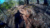
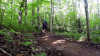
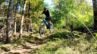
Photos of Bonshaw Mountain Bike
Videos of Bonshaw Mountain Bike

trail: Goat Trail
0:58 |
29 |
Apr 22, 2023

trail: Cotton Valley
0:56 |
27 |
May 4, 2020
trail: Appin Road Trail - East
0:50 |
68 |
May 4, 2020
trail: Elliott River Run
0:50 |
387 |
Sep 5, 2016

trail: Parking Lot
5:18 |
109 |
Aug 22, 2015
trail: St Catherines
0:16 |
401 |
Dec 19, 2021 , Bonshaw

trail: Parkside Trail
0:58 |
329 |
Oct 9, 2021 , Bonshaw

trail: Prince's Loop Trail
0:25 |
216 |
Oct 9, 2021 , Bonshaw
Recent Trail Reports
| status | trail | date | condition | info | user |
|---|---|---|---|---|---|
| Elliott River Run | Aug 7, 2025 @ 10:45am Aug 7, 2025 | Dry | lplug MRWA | ||
| Howell's Hollow | Aug 7, 2025 @ 10:45am Aug 7, 2025 | Dry | lplug MRWA | ||
| Ravine | Aug 7, 2025 @ 10:45am Aug 7, 2025 | Dry | lplug MRWA | ||
| Howell's Hollow | Aug 7, 2025 @ 10:45am Aug 7, 2025 | Dry | lplug MRWA | ||
| Fox Run | Aug 7, 2025 @ 10:45am Aug 7, 2025 | Dry | lplug MRWA | ||
| Switchback | Aug 7, 2025 @ 10:45am Aug 7, 2025 | Dry | lplug MRWA | ||
| Spruce Grove Trail | Aug 7, 2025 @ 10:45am Aug 7, 2025 | Dry | lplug MRWA | ||
| Al's Orchard | Aug 7, 2025 @ 10:45am Aug 7, 2025 | Dry | lplug MRWA | ||
| Canopy Trail | Aug 7, 2025 @ 10:45am Aug 7, 2025 | Dry | lplug MRWA | ||
| Prince's Loop Trail | Aug 7, 2025 @ 10:45am Aug 7, 2025 | Dry | lplug MRWA |
Activity Feed
| username | action | type | title | date |
|---|---|---|---|---|
| NathanCn5LG2 | wishlist | trail | activity #93428193 | Apr 26, 2026 @ 4:23am Apr 26, 2026 |
| xtrmplntx | wishlist | trail | activity #93372827 | Apr 25, 2026 @ 10:48am Apr 25, 2026 |
| DarlaWGAPFo | wishlist | region | activity #87981114 | Jan 29, 2026 @ 3:32am Jan 29, 2026 |
| shoesy | wishlist | region | activity #78501269 | Aug 19, 2025 @ 1:56pm Aug 19, 2025 |
| nfortierc514 | ridden | trail | activity #77960791 and 2 more | Aug 12, 2025 @ 4:59am Aug 12, 2025 |
Recent Comments
| username | type | title | comment | date |
|---|---|---|---|---|
| trail | Corker | Nov 8, 2024 @ 9:23am Nov 8, 2024 | ||
| trail | She’s a dandy that’s fer shore | Jul 22, 2023 @ 2:12pm Jul 22, 2023 | ||
| trail | Rough trail on a bike. A lot of large... | Oct 9, 2021 @ 3:27am Oct 9, 2021 | ||
| report | Fallen tree here | Jul 17, 2021 @ 6:15am Jul 17, 2021 | ||
| trail | Awesome trail that has great features in... | Jun 26, 2021 @ 11:14am Jun 26, 2021 |
Local Badges
-

10 Blue Trails83 awarded -

Epic Mountain Bike Climb 2k0 awarded -

Climbing 10k Badge6 awarded -

Mountain Biking 100k Badge0 awarded -

Epic Ride Descent 2k0 awarded -

Descent 10k Badge7 awarded
Activity Type Stats
| activitytype | trails | distance | descent | descent distance | total vertical | rating | global rank | state rank | photos | reports | routes | ridelogs |
|---|---|---|---|---|---|---|---|---|---|---|---|---|
| Mountain Bike | 37 | 28 miles | 3,894 ft | 13 miles | 338 ft | #3,736 | #2 | 41 | 323 | 3 | 3,552 | |
| Hike | 38 | 29 miles | 3,957 ft | 13 miles | 338 ft | #6,395 | #1 | 2 | 323 | 250 | ||
| Trail Running | 38 | 29 miles | 3,957 ft | 13 miles | 338 ft | #5,927 | #1 | 323 | 121 | |||
| Snowshoe | 38 | 29 miles | 3,957 ft | 13 miles | 338 ft | #698 | #1 | 9 | 14 |
Frequently Asked Questions About Bonshaw
▼
What are the best places to ride in Bonshaw?
Bonshaw has 1 areas to explore for mountain biking. The top rated areas are:
▼
What are the highest rated mountain biking trails in Bonshaw?
The highest rated mountain biking trails in Bonshaw are:
- Howell's Hollow (4.2/5)
- Elliott River Run (4.2/5)
- Parkside Trail (4.2/5)
- Canopy Trail (4.1/5)
- Al's Orchard (4/5)
▼
What is the best time of the year to ride in Bonshaw?
Based on ride log data, the most popular months to ride in Bonshaw are:
- May (49 activities)
- August (43 activities)
- September (40 activities)
▼
Where can I park to ride in Bonshaw?
There are 5 parking locations listed in Bonshaw. The most popular parking spots are:
- Mackinnon Road Parking
- Parking Bonshaw Day Park
- Strathgartney Parking
- Bonshaw Parking
- Green Road Parking
Activities
- By bruce9494 & contributors
- Admins: CPEI, bent6543, PARKSPEI
- #13069 - 8,191 views
- bonshaw activity log | embed map of Bonshaw mountain bike trails | bonshaw mountain biking points of interest
Downloading of trail gps tracks in kml & gpx formats is enabled for Bonshaw.
You must login to download files.