close
-
Layers w
- Weather Layers
- Pro
- Pro
- Pro
- Pro
- Pro
- Pro
- More Layers
- Pro
- Pro
- Pro
- Pro
-
Upgrade to

3D
Trail Conditions
- Unknown
- Snow Groomed
- Snow Packed
- Snow Covered
- Snow Cover Partial
- Freeze/thaw Cycle
- Icy
- Prevalent Mud
- Wet
- Variable
- Ideal
- Dry
- Very Dry
Trail Flow (Ridden Direction)
Trailforks scans users ridelogs to determine the most popular direction each trail is ridden. A good flowing trail network will have most trails flowing in a single direction according to their intension.
The colour categories are based on what percentage of riders are riding a trail in its intended direction.
The colour categories are based on what percentage of riders are riding a trail in its intended direction.
- > 96%
- > 90%
- > 80%
- > 70%
- > 50%
- < 50%
- bi-directional trail
- no data
Trail Last Ridden
Trailforks scans ridelogs to determine the last time a trail was ridden.
- < 2 days
- < 1 week
- < 2 weeks
- < 1 month
- < 6 months
- > 6 months
Trail Ridden Direction
The intended direction a trail should be ridden.
- Downhill Only
- Downhill Primary
- Both Directions
- Uphill Primary
- Uphill Only
- One Direction
Contribute Details
Colors indicate trail is missing specified detail.
- Description
- Photos
- Description & Photos
- Videos
Trail Popularity ?
Trailforks scans ridelogs to determine which trails are ridden the most in the last 9 months.
Trails are compared with nearby trails in the same city region with a possible 25 colour shades.
Think of this as a heatmap, more rides = more kinetic energy = warmer colors.
- most popular
- popular
- less popular
- not popular
ATV/ORV/OHV Filter
Max Vehicle Width
inches
US Cell Coverage
Legend

Radar Time
Activity Recordings
Trailforks uses anonymized public activity data.
?
Activity Recordings
Trailforks uses anonymized public activity data.
?
Personal Heatmap
▶
Activity Types
all
/
none
▶
Options
2
Date range
month
–
Winter Trails
Warning
A routing network for winter maps does not exist. Selecting trails using the winter trails layer has been disabled.
Missing Trails
Most Popular
Least Popular
Trails are colored based on popularity. The more popular a trail is, the more red. Less popular trails trend towards green.
Jump Magnitude Heatmap
Heatmap of where riders jump on trails. Zoom in to see individual jumps, click circles to view jump details.
BC Backroad Status
![map legend]()
Service Road Atlas is a free to use, community-driven service for viewing and creating reports on the numerous back-country service roads around B.C. and Alberta.

Slope Aspect
Direction the slope faces
Trails Deemphasized
Trails are shown in grey.
Only show trails with no bike usage.
Suggested Layers
Based on selected activity type
Save the current map location and zoom level as your default home location whenever this page is loaded.
Save
No description for Boppard has been added yet!
Login or register to submit one.
This region uses the Uk/Euro style trail grading system.
Activities Click to view
- Mountain Bike
10 trails
- E-Bike
11 trails
- Adaptive Bike
1 trails
- Hike
7 trails
- Trail Running
7 trails
Region Details
- 3
- 4
- 3
Region Status
Open as of May 9, 2026Stats
- Avg Trail Rating
- Trails (view details)
- 10
- Trails Mountain Bike
- 11
- Trails E-Bike
- 11
- Trails Adaptive Bike
- 1
- Trails Hike
- 7
- Trails Trail Running
- 7
- Total Distance
- 6 miles
- Total Descent
- 4,430 ft
- Total Vertical
- 1,299 ft
- Highest Trailhead
- 1,715 ft
- Reports
- 27
- Photos
- 3
- Ridden Counter
- 436
Popular Boppard Mountain Biking Trails
• 90 ★ 4.7 • 1 mile • 44 ft • 90 •
Highly rated popular red difficulty singletrack. This mountain bike primary trail can be used downhill only. It features rock garden. On average it takes 8 minutes to complete this trail.
• 95 ★ 4.1 • 2,841 ft • 30 ft • 80 •
Highly rated popular red difficulty machine groomed. This mountain bike primary trail can be used downhill only. It features berm, drop, jump, gap jump and wallride. Trail visibility is always easy to follow. On average it takes 11 minutes to complete this trail.
• 65 ★ 4.5 • 2,733 ft • 0 ft • 59 •
Highly rated moderately popular black difficulty singletrack. This mountain bike primary trail can be used downhill only. It features rock garden. Trail visibility is always easy to follow. On average it takes 10 minutes to complete this trail.
• 100 ★ 4.5 • 2,172 ft • 0 ft • 53 •
Highly rated popular black difficulty singletrack. This mountain bike primary trail can be used downhill only. On average it takes 12 minutes to complete this trail.
• 75 ★ 4.0 • 1,165 ft • 0 ft • 30 •
Popular green difficulty family friendly singletrack. This mountain bike primary trail can be used downhill only and has a easy overall physical rating. It features jump and gap jump. Trail visibility is always easy to follow. On average it takes 2 minutes to complete this trail.
• 5 ★ 3.8 • 2 miles • 132 ft • 18 •
Less popular blue difficulty singletrack. This multi-use trail can be used downhill primary. Trail visibility is always easy to follow. On average it takes 23 minutes to complete this trail.
• 50 ★ 5.0 • 554 ft • 4 ft • 15 •
Moderately popular black difficulty singletrack. This mountain bike primary trail can be used both directions. On average it takes 2 minutes to complete this trail.
• 5 ★ 0.0 • 2,234 ft • 34 ft • 13 •
Less popular blue difficulty singletrack. This multi-use trail can be used downhill primary. On average it takes 4 minutes to complete this trail.
Videos of Boppard Mountain Bike

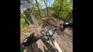
trail: Utah
4:07 |
8640 |
Oct 12, 2015

trail: Utah
3:25 |
285 |
Jan 19, 2015
trail: Alter Wolfskopf
6:12 |
25 |
Apr 21, 2026 , Boppard

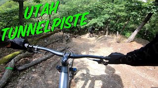
trail: Tunnelpiste
74 |
Jun 20, 2025 , Boppard

trail: Alter Wolfskopf
95 |
Jun 20, 2025 , Boppard

trail: Utah
109 |
Jun 20, 2025 , Boppard

trail: Tunnelpiste
9:25 |
292 |
May 20, 2023 , Boppard
trail: Utah
9:25 |
888 |
Apr 4, 2021 , Boppard
Recent Trail Reports
| status | trail | date | condition | info | user |
|---|---|---|---|---|---|
| Tunnelpiste | May 9, 2026 @ 10:49am (Europe/Luxembourg) May 9, 2026 | Ideal | kroegi | ||
| Alter Wolfskopf | Apr 20, 2026 @ 4:19pm (Europe/Berlin) Apr 20, 2026 | Ideal | kroegi | ||
| Utah Abzweig | Feb 8, 2026 @ 12:25pm (Europe/Berlin) Feb 8, 2026 | Variable | balduini | ||
| Utah | Feb 8, 2026 @ 12:25pm (Europe/Berlin) Feb 8, 2026 | Variable | balduini | ||
| Bikepark Track | Aug 17, 2025 @ 12:45pm Aug 17, 2025 | Dry | HorstF | ||
| Fleckertshoehe Trail | Aug 11, 2024 @ 4:31am Aug 11, 2024 | Dry | HorstF | ||
| Sabelskopf Trail | Jun 12, 2020 @ 1:10am Jun 12, 2020 | Ideal | PorroA |
Activity Feed
| username | action | type | title | date |
|---|---|---|---|---|
| l5wvXz | ridden | trail | activity #94569663 | May 12, 2026 @ 10:39am May 12, 2026 |
| kroegi | ridden | trail | activity #94414273 and 2 more | May 10, 2026 @ 4:40am May 10, 2026 |
| kroegi | add | report | activity #94413288 and 1 more | May 10, 2026 @ 4:24am May 10, 2026 |
| ChrisChanT | wishlist | trail | activity #93659853 | Apr 29, 2026 @ 11:02am Apr 29, 2026 |
| KrahnvNrkXj | wishlist | trail | activity #93540075 | Apr 27, 2026 @ 2:19pm Apr 27, 2026 |
Recent Comments
| username | type | title | comment | date |
|---|---|---|---|---|
| trail | Perfekte Bedingungen. Kein Gegenverkehr, keine... | Apr 20, 2026 @ 7:20am Apr 20, 2026 | ||
| trail | Rode it last saturday. Condition was fine! | Sep 25, 2023 @ 2:39am Sep 25, 2023 | ||
| trail | Bremspunkten bevor sharfe kurven sind völlig... | Jun 27, 2023 @ 4:13am Jun 27, 2023 | ||
| trail | Die Forst beamten habe schilder hingehangen... | Jun 27, 2023 @ 4:12am Jun 27, 2023 | ||
| trail | My favorite Trail! But from the railway... | May 18, 2022 @ 7:13am May 18, 2022 |
Activity Type Stats
| activitytype | trails | distance | descent | descent distance | total vertical | rating | global rank | state rank | photos | reports | routes | ridelogs |
|---|---|---|---|---|---|---|---|---|---|---|---|---|
| Mountain Bike | 10 | 6 miles | 4,429 ft | 5 miles | 1,299 ft | #6,860 | #223 | 3 | 27 | 595 | ||
| E-Bike | 11 | 6 miles | 4,429 ft | 5 miles | 1,299 ft | #5,161 | #171 | 25 | 234 | |||
| Adaptive Bike | 1 | #216 | #159 | |||||||||
| Hike | 7 | 5 miles | 3,064 ft | 4 miles | 1,299 ft | #8,751 | #175 | 24 | 175 | |||
| Trail Running | 7 | 5 miles | 3,064 ft | 4 miles | 1,299 ft | #8,366 | #175 | 24 | 5 |
Frequently Asked Questions About Boppard
▼
What are the highest rated mountain biking trails in Boppard?
The highest rated mountain biking trails in Boppard are:
- Alter Wolfskopf (4.3/5)
- Utah (4.2/5)
- Tunnelpiste (4.2/5)
- Utah Abzweig (4.1/5)
- Wolfskopf Alternate (4.1/5)
▼
What is the best time of the year to ride in Boppard?
Based on ride log data, the most popular months to ride in Boppard are:
- May (8 activities)
- April (5 activities)
- September (4 activities)
▼
Where can I park to ride in Boppard?
Check the Boppard trail map for trailhead and parking information. Community members regularly update access and parking details for trails in the area.
▼
What is the longest trail in Boppard?
The longest trail in Boppard is Fleckertshoehe Trail at 4.0 km. View all trails sorted by distance.
Activities
Trails
Points of Interest
- By tradailvoc
 & contributors
 - Admins: PB, Janne88, Janne88
- #26172 - 4,476 views
- boppard activity log | embed map of Boppard mountain bike trails | boppard mountain biking points of interest
Downloading of trail gps tracks in kml & gpx formats is enabled for Boppard.
You must login to download files.