close
-
Layers w
- Weather Layers
- Pro
- Pro
- Pro
- Pro
- Pro
- Pro
- More Layers
- Pro
- Pro
- Pro
- Pro
-
Upgrade to

3D
Trail Conditions
- Unknown
- Snow Groomed
- Snow Packed
- Snow Covered
- Snow Cover Partial
- Freeze/thaw Cycle
- Icy
- Prevalent Mud
- Wet
- Variable
- Ideal
- Dry
- Very Dry
Trail Flow (Ridden Direction)
Trailforks scans users ridelogs to determine the most popular direction each trail is ridden. A good flowing trail network will have most trails flowing in a single direction according to their intension.
The colour categories are based on what percentage of riders are riding a trail in its intended direction.
The colour categories are based on what percentage of riders are riding a trail in its intended direction.
- > 96%
- > 90%
- > 80%
- > 70%
- > 50%
- < 50%
- bi-directional trail
- no data
Trail Last Ridden
Trailforks scans ridelogs to determine the last time a trail was ridden.
- < 2 days
- < 1 week
- < 2 weeks
- < 1 month
- < 6 months
- > 6 months
Trail Ridden Direction
The intended direction a trail should be ridden.
- Downhill Only
- Downhill Primary
- Both Directions
- Uphill Primary
- Uphill Only
- One Direction
Contribute Details
Colors indicate trail is missing specified detail.
- Description
- Photos
- Description & Photos
- Videos
Trail Popularity ?
Trailforks scans ridelogs to determine which trails are ridden the most in the last 9 months.
Trails are compared with nearby trails in the same city region with a possible 25 colour shades.
Think of this as a heatmap, more rides = more kinetic energy = warmer colors.
- most popular
- popular
- less popular
- not popular
ATV/ORV/OHV Filter
Max Vehicle Width
inches
US Cell Coverage
Legend

Radar Time
Activity Recordings
Trailforks uses anonymized public activity data.
?
Activity Recordings
Trailforks uses anonymized public activity data.
?
Personal Heatmap
▶
Activity Types
all
/
none
▶
Options
2
Date range
month
–
Winter Trails
Warning
A routing network for winter maps does not exist. Selecting trails using the winter trails layer has been disabled.
Missing Trails
Most Popular
Least Popular
Trails are colored based on popularity. The more popular a trail is, the more red. Less popular trails trend towards green.
Jump Magnitude Heatmap
Heatmap of where riders jump on trails. Zoom in to see individual jumps, click circles to view jump details.
BC Backroad Status
![map legend]()
Service Road Atlas is a free to use, community-driven service for viewing and creating reports on the numerous back-country service roads around B.C. and Alberta.

Slope Aspect
Direction the slope faces
Trails Deemphasized
Trails are shown in grey.
Only show trails with no bike usage.
Suggested Layers
Based on selected activity type
Save the current map location and zoom level as your default home location whenever this page is loaded.
SavePopular Trail Networks
view all areas »Activities Click to view
- Mountain Bike
698 trails
- E-Bike
321 trails
- Horse
265 trails
- Hike
914 trails
- Trail Running
918 trails
- Dirtbike/Moto
62 trails
- Observed Trials
10 trails
- ATV/ORV/OHV
52 trails
- Snowmobile
8 trails
- Snowshoe
42 trails
- Downhill Ski
68 trails
- Backcountry Ski
22 trails
- Nordic Ski
24 trails
Stats
- Avg Trail Rating
- Trails (view details)
- 1,027
- Trails Mountain Bike
- 700
- Trails E-Bike
- 321
- Trails Gravel Bike
- 1
- Trails Horse
- 265
- Trails Hike
- 919
- Trails Trail Running
- 918
- Trails Dirtbike/Moto
- 62
- Trails Observed Trials
- 10
- Trails ATV/ORV/OHV
- 52
- Trails Snowmobile
- 8
- Trails Snowshoe
- 42
- Trails Downhill Ski
- 68
- Trails Backcountry Ski
- 22
- Trails Nordic Ski
- 32
- Total Distance
- 1,066 miles
- Total Descent
- 173,539 ft
- Total Vertical
- 8,630 ft
- Highest Trailhead
- 13,460 ft
- Reports
- 18,964
- Photos
- 1,259
- Ridden Counter
- 234,043
Articles
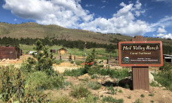
Boulder County Proposes Major Trail Restrictions for Mountain Bikers
May 11, 2026 from pinkbike.com
Access at Hall Ranch and Heil Valley is under fire. Learn how a "design problem" is being treated as a "user problem" and how you can take action.
More Than Miles: Here’s How to Plan the Perfect Runcation
Aug 1, 2025 from outsideonline.com
Running trips—from Utah's desert to Patagonia's peaks—offer the most thrilling (and humbling) adventures this writer's ever experienced.
An Insider’s Guide to the Best Hikes in Boulder, Colorado
Feb 26, 2024 from outsideonline.com
After 25 years of hiking in his hometown of Boulder, guidebook author James Dziezynski reveals his all-time favorite treks in the area. Plus,...
Sub Regions
- Allenspark (13)
- Taylor Mountain (9)
- Boulder (240)
- Betasso Preserve (6)
- Boulder Open Space (2)
- Boulder Valley Ranch / Boulder Reservoir (17)
- CU South Campus (11)
- Eldorado Canyon State Park (2)
- Lefthand OHV (64)
- Marshall Mesa/Doudy Draw/Flatirons Vista (22)
- Teller Farm Open Space (3)
- The People's Crossing Park (0)
- Valmont Bike Park (43)
- Walker Mountain (17)
- Walker Ranch (5)
- Erie (33)
- Erie Singletrack (20)
- Gunbarrel (24)
- Jamestown (29)
- Ceran Saint Vrain (33)
- Lafayette (13)
- Longmont (27)
- Louisville (63)
- Davidson Mesa (16)
- Lyons (18)
- Nederland (163)
- Caribou (18)
- Magnolia (89)
- Mud Lake (15)
- Sugarloaf Mountain (1)
- Tolland (9)
- Niwot (7)
- Superior (14)
- Coyote Ridge (8)
- Ward (34)
- Gold Hill (5)
Popular Boulder County Mountain Biking Trails
• 100 ★ 3.2 • 2 miles • 90 ft • 2,622 •
Mayhoffer Singltree is another connector piece of the Dirty Bismark loop. It was one of the final sections opened. The trail has a very nice easy grade and no rocks at all! It's fantastic for beginners and young 'uns.
• 100 ★ 4.2 • 1 mile • 448 ft • 2,436 •
Upper is a bi-directional trail used to access the at the top of Hall ranch. The climb up is smooth, sustained, and easy. The descent is very fast and fun, mostly smooth with only one or two rocky sections!
• 100 ★ 4.6 • 2 miles • 323 ft • 2,322 •
is when the fun descending of Hall Ranch begins! Climb all the way up to and prepare for a fast descent the entire way down! This trail is a bi-directional loop but is best when ridden in a clockwise direction. If it has rained or...
• 95 ★ 3.7 • 4,931 ft • 0 ft • 2,050 •
is a fun trail both climbing and descending. This trail is mostly used as an alternative to climbing or descending the very technical Lower trail and can be used to access the upper parts of Hall ranch. Expect fun twisty singletrack,...
• 100 ★ 3.9 • 3,675 ft • 165 ft • 1,925 •
The connects the popular and trails. While the loops are direction for bikes, the is bidirectional with some exposure and blind corners so caution is recommended. Going from Canyon to Benji, the trail descends to a drainage and then...
• 90 ★ 4.5 • 2 miles • 61 ft • 1,919 •
Very deserving of its black diamond rating. Lower reminds me of desert riding in southern Utah, almost like a steeper version of UPS/LPS in Moab. Suffice it to say, there are many technical rock features, interspersed with brief patches...
• 90 ★ 4.0 • 2 miles • 497 ft • 1,764 •
is directional for bikers, and the direction changes approximately every four weeks. Please follow posted signs. The preferred direction from the Link Loop is clockwise (not that you have a choice, just be excited if that's the...
• 95 ★ 3.0 • 1,420 ft • 12 ft • 1,648 •
Singletrack connector from to Springbook Loop.
Boulder County Mountain Bike Routes
Hall Ranch Technical Side Featured
★ 5.0 • 10 miles • 1,594 ft • 6 • Out & Back •
Tackling Hall Ranch up aka "The Rock Garden" bumps this intermediate/advanced area into solid double...
Hall Ranch: Intermediate Fun Featured
★ 4.4 • 7 miles • 1,191 ft • 5 • Out & Back •
This is an great alternative if you're not up to the black diamond challenge. It's primarily uphill all...
Marshall Mesa Doudy Draw Loop Featured
★ 4.0 • 12 miles • 988 ft • 14 • Loop •
This route gives a great tour of the best trails Marshall Mesa has to offer. The ride starts at the main...
Marshall Mesa Beginner Ride Featured
★ 4.0 • 5 miles • 272 ft • 1 • Out & Back •
The Boulder Mountainbike Alliance's Recommendation for Easiest Ride at Marshall Mesa. People in Boulder...
Buchanan Waterfall out-and-back Featured
★ 5.0 • 7 miles • 824 ft • 1 • Out & Back •
Located at Camp Dick, it’s no secret this is probably one of the best singletracks around for fat...
North Boulder MTB Featured
★ 5.0 • 12 miles • 854 ft • 5 • Loop •
Starting in 2024, singletrack options north of Boulder just got a whole lot better! The opened in July and...
Photos of Boulder County Mountain Bike
Videos of Boulder County Mountain Bike
trail: Eaton Dirt Jumps
0:08 |
7 |
Jun 2, 2026
trail: Eaton Dirt Jumps
0:09 |
4 |
Jun 2, 2026
trail: Eaton Dirt Jumps
0:08 |
3 |
Jun 2, 2026

trail: Valmont Paved Pumptrack
0:09 |
22 |
Jan 10, 2026
trail: Lower Bitterbrush
0:05 |
50 |
Jan 10, 2026

trail: Deadass
0:24 |
85 |
Jan 12, 2024
trail: David Lee Roth
0:08 |
328 |
Nov 8, 2023

trail: Slopestyle L
0:23 |
57 |
Nov 8, 2023
Recent Trail Reports
National Scenic Trails & Official Routes
-
Continental Divide Trail
- Mountain Bike
- Hike
- Trail Running

Activity Feed
| username | action | type | title | date |
|---|---|---|---|---|
| TimIl23DW | add | report | activity #98122744 and 2 more | Jun 30, 2026 @ 5:35am 3 hours |
| Kravibikes | wishlist | route | activity #98111550 | Jun 29, 2026 @ 11:49pm 9 hours |
| DzCloudCity | add | report | activity #98100226 | Jun 29, 2026 @ 6:15pm 15 hours |
| Kjr375 | wishlist | route | activity #98074004 | Jun 29, 2026 @ 10:42am 22 hours |
| deaconb | add | photo | activity #98038564 and 3 more | Jun 28, 2026 @ 6:20pm 2 days |
Recent Comments
| username | type | title | comment | date |
|---|---|---|---|---|
| trail | A hidden gem. Mostly doable climb too. | Jun 23, 2026 @ 12:26pm Jun 23, 2026 | ||
| trail | Not sure what this used to be like, but now... | Jun 13, 2026 @ 3:08pm Jun 13, 2026 | ||
| trail | “What trails do you want to do... | Jun 2, 2026 @ 11:51am Jun 2, 2026 | ||
| report | Yay | May 15, 2026 @ 9:00am May 15, 2026 | ||
| report | Marshall mesa and Dowdy all dry and running great | Apr 19, 2026 @ 10:05am Apr 19, 2026 |
Local Badges
-

Epic Ride 50k1,328 awarded -

Mountain Biking 100k Badge0 awarded -

Climbing 10k Badge7 awarded -

Epic Mountain Bike Climb 2k1 awarded -

Epic Ride Descent 2k1 awarded -

Big Ride 30k3,634 awarded
Bike & Skill Parks
| name | type | city | rating |
|---|---|---|---|
| Eldora Mountain Resort | bike park | Nederland | |
| Valmont Bike Park | skill park | Boulder | |
| Lyons Bike Park | skill park | Lyons | |
| Velosolutions Pump Track Superior, Colorado | skill park | Superior | |
| IMI Motorsports Complex | skill park | Erie |
Activity Type Stats
| activitytype | trails | distance | descent | descent distance | total vertical | rating | global rank | state rank | photos | reports | routes | ridelogs |
|---|---|---|---|---|---|---|---|---|---|---|---|---|
| Mountain Bike | 698 | 735 miles | 85,853 ft | 315 miles | 6,946 ft | 1,059 | 18,689 | 86 | 258,008 | |||
| E-Bike | 321 | 398 miles | 29,121 ft | 165 miles | 6,841 ft | 4 | 10,391 | 3 | 8,772 | |||
| Gravel Bike | 1 | 4 | 97 | 7 | 3,655 | |||||||
| Horse | 265 | 354 miles | 58,478 ft | 152 miles | 8,458 ft | 3,247 | 50 | 12 | ||||
| Hike | 914 | 1,025 miles | 155,374 ft | 446 miles | 8,632 ft | 204 | 17,362 | 81 | 29,116 | |||
| Trail Running | 918 | 1,019 miles | 154,652 ft | 444 miles | 8,632 ft | 5 | 17,359 | 78 | 33,805 | |||
| Dirtbike/Moto | 62 | 139 miles | 14,147 ft | 56 miles | 4,905 ft | 4 | 2,245 | 1 | 67 | |||
| Observed Trials | 10 | 22 miles | 2,238 ft | 10 miles | 1,788 ft | 2 | 46 | 8 | ||||
| ATV/ORV/OHV | 52 | 123 miles | 11,690 ft | 51 miles | 4,905 ft | 2,244 | 1 | 6 | ||||
| Snowmobile | 8 | 18 miles | 1,634 ft | 6 miles | 1,801 ft | 17 | 1 | 2 | ||||
| Snowshoe | 42 | 69 miles | 7,618 ft | 24 miles | 7,152 ft | 215 | 44 | 275 | ||||
| Downhill Ski | 68 | 15 miles | 14,501 ft | 15 miles | 1,342 ft | 7 | 3,911 | |||||
| Backcountry Ski | 22 | 40 miles | 1,568 ft | 7 miles | 4,354 ft | 182 | 2,967 | |||||
| Nordic Ski | 24 | 71 miles | 8,481 ft | 29 miles | 3,478 ft | 215 | 10 | 1,679 |
Frequently Asked Questions About Boulder County
▼
What are the best places to ride in Boulder County?
Boulder County has 38 areas to explore for mountain biking. The top rated areas are:
▼
What are the highest rated mountain biking trails in Boulder County?
The highest rated mountain biking trails in Boulder County are:
- Slopestyle L (4.6/5)
- Corkscrew (4.5/5)
- GZA (4.5/5)
- Nelson Loop (4.5/5)
- Brown Town (4.4/5)
▼
What is the best time of the year to ride in Boulder County?
Based on ride log data, the most popular months to ride in Boulder County are:
- July (1,222 activities)
- August (814 activities)
- June (810 activities)
▼
What is the longest trail in Boulder County?
The longest trail in Boulder County is Coal Creek Trail at 14.5 miles. View all trails sorted by distance.
Activities
- Boulder County Mountain Biking Trails
- Boulder County E-Biking Trails
- Boulder County Horseback Trails
- Boulder County Hiking Trails
- Boulder County Trail Running Trails
- Boulder County Dirtbiking Trails
- Boulder County Observed Trials Trails
- Boulder County ATVing/Offroading Trails
- Boulder County Snowmobiling Trails
- Boulder County Snowshoeing Trails
- Boulder County Skiing Trails
- Boulder County Backcountry Skiing Trails
- Boulder County Nordic Skiing Trails
Trails
Points of Interest
- Continental Divide Overlook Viewpoint
- Paiute Peak Summit
- Nordic Center Lodge
- Guinn Mountain Summit
- Guinn Mountain Hut Cabin
- Indian Peak Lodge
- South Boulder Peak Summit
- Shirttall Peak Summit
- Nebel Horn Summit
- Crags Hotel Ruins Sight
- North Arapaho Peak (13,451 ft)
- Apache Peak (13,445 ft)
- South Arapaho Peak (13,392 ft)
- By roaming50
 & contributors
 - Admins: jpmcghee, msmcfate, cmcquade, BMA, mattoid, amrosen, getvert, mpopetz, Pumpntrail, andrewbikeboulder
- #15769 - 25,279 views
- boulder county activity log | embed map of Boulder County mountain bike trails | boulder county mountain biking points of interest
Downloading of trail gps tracks in kml & gpx formats is enabled for Boulder County.
You must login to download files.