close
-
Layers w
- Weather Layers
- Pro
- Pro
- Pro
- Pro
- Pro
- Pro
- More Layers
- Pro
- Pro
- Pro
- Pro
-
Upgrade to

3D
Trail Conditions
- Unknown
- Snow Groomed
- Snow Packed
- Snow Covered
- Snow Cover Partial
- Freeze/thaw Cycle
- Icy
- Prevalent Mud
- Wet
- Variable
- Ideal
- Dry
- Very Dry
Trail Flow (Ridden Direction)
Trailforks scans users ridelogs to determine the most popular direction each trail is ridden. A good flowing trail network will have most trails flowing in a single direction according to their intension.
The colour categories are based on what percentage of riders are riding a trail in its intended direction.
The colour categories are based on what percentage of riders are riding a trail in its intended direction.
- > 96%
- > 90%
- > 80%
- > 70%
- > 50%
- < 50%
- bi-directional trail
- no data
Trail Last Ridden
Trailforks scans ridelogs to determine the last time a trail was ridden.
- < 2 days
- < 1 week
- < 2 weeks
- < 1 month
- < 6 months
- > 6 months
Trail Ridden Direction
The intended direction a trail should be ridden.
- Downhill Only
- Downhill Primary
- Both Directions
- Uphill Primary
- Uphill Only
- One Direction
Contribute Details
Colors indicate trail is missing specified detail.
- Description
- Photos
- Description & Photos
- Videos
Trail Popularity ?
Trailforks scans ridelogs to determine which trails are ridden the most in the last 9 months.
Trails are compared with nearby trails in the same city region with a possible 25 colour shades.
Think of this as a heatmap, more rides = more kinetic energy = warmer colors.
- most popular
- popular
- less popular
- not popular
ATV/ORV/OHV Filter
Max Vehicle Width
inches
US Cell Coverage
Legend

Radar Time
Activity Recordings
Trailforks uses anonymized public activity data.
?
Activity Recordings
Trailforks uses anonymized public activity data.
?
Personal Heatmap
▶
Activity Types
all
/
none
▶
Options
2
Date range
month
–
Winter Trails
Warning
A routing network for winter maps does not exist. Selecting trails using the winter trails layer has been disabled.
Missing Trails
Most Popular
Least Popular
Trails are colored based on popularity. The more popular a trail is, the more red. Less popular trails trend towards green.
Jump Magnitude Heatmap
Heatmap of where riders jump on trails. Zoom in to see individual jumps, click circles to view jump details.
BC Backroad Status
![map legend]()
Service Road Atlas is a free to use, community-driven service for viewing and creating reports on the numerous back-country service roads around B.C. and Alberta.

Slope Aspect
Direction the slope faces
Trails Deemphasized
Trails are shown in grey.
Only show trails with no bike usage.
Suggested Layers
Based on selected activity type
Save the current map location and zoom level as your default home location whenever this page is loaded.
Save
No description for Bracknell has been added yet!
Login or register to submit one.
This region uses the Uk/Euro style trail grading system.
Activities Click to view
- Mountain Bike
75 trails
- E-Bike
69 trails
- Gravel Bike
0 trails
- Adaptive Bike
0 trails
- Winter Fat Bike
0 trails
- Horse
9 trails
- Hike
23 trails
- Trail Running
23 trails
- Dirtbike/Moto
4 trails
Region Details
- 15
- 1
- 17
- 32
- 2
Region Status
Open as of 3 daysStats
- Avg Trail Rating
- Trails (view details)
- 67
- Trails Mountain Bike
- 75
- Trails E-Bike
- 69
- Trails Horse
- 9
- Trails Hike
- 23
- Trails Trail Running
- 23
- Trails Dirtbike/Moto
- 4
- Total Distance
- 27 miles
- Total Descent
- 2,090 ft
- Total Vertical
- 214 ft
- Highest Trailhead
- 465 ft
- Reports
- 3,464
- Photos
- 486
- Ridden Counter
- 119,699
Sub Regions
-
Crowthorne Woods
-
Swinley Forest
- 1
- 16
- 27
- 2
Popular Bracknell Mountain Biking Trails
• 100 ★ 3.3 • 843 ft • 17 ft • 2,724 •
Popular blue difficulty singletrack. This mountain bike primary trail can be used one direction. On average it takes 2 minutes to complete this trail.
• 80 ★ 3.6 • 2,516 ft • 6 ft • 2,591 •
Popular blue difficulty singletrack. This mountain bike primary trail can be used one direction. On average it takes minutes to complete this trail.
• 85 ★ 3.5 • 1,293 ft • 32 ft • 2,557 •
Popular blue difficulty singletrack. This mountain bike primary trail can be used one direction. On average it takes 2 minutes to complete this trail.
• 75 ★ 3.4 • 1,506 ft • 20 ft • 2,550 •
Popular blue difficulty singletrack. This mountain bike primary trail can be used one direction. On average it takes 1 minutes to complete this trail.
• 80 ★ 3.4 • 1,440 ft • 46 ft • 2,522 •
Popular blue difficulty singletrack. This mountain bike primary trail can be used one direction with a 46 ft blue climb. On average it takes 2 minutes to complete this trail.
• 70 ★ 3.3 • 1,102 ft • 6 ft • 2,499 •
Popular blue difficulty singletrack. This mountain bike primary trail can be used one direction. On average it takes 1 minutes to complete this trail.
• 95 ★ 4.9 • 2,887 ft • 18 ft • 2,450 •
One the best DH trails in Swinley. It combines a bike park type of trail with a rather gnarly root section near the end. Trail features include berms, a switchback, a couple of rollable small jumps and a succession of small drops and roots.
• 100 ★ 3.0 • 1,001 ft • 2 ft • 2,410 •
Popular blue difficulty singletrack. This mountain bike primary trail can be used one direction. On average it takes 1 minutes to complete this trail.
Bracknell Mountain Bike Routes
★ 5.0 • 8 miles • 593 ft • 15 • Loop •
Red Route at Swinley. All Weather trail
★ 3.0 • 5 miles • 255 ft • 14 • Loop •
Blue Route – 7.3km – moderate – bermed single track, with hills and dips winding through the pine forest
★ 5.0 • 12 miles • 830 ft • 27 • Loop •
A full run of the Blue and Red trails of Swinley Forest, returning to the Trailhead.
★ 4.5 • 2,992 ft • 15 ft • 1 • Loop •
Easy route for starting out on your bike
1 mile • 88 ft • 1 • Point to Point •
To get to the start of the Red you can either go out on the Blue then pick up or ride direct to the Red on...
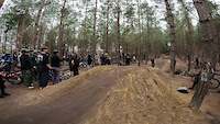
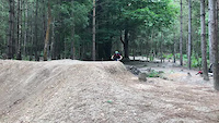
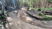
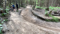
Photos of Bracknell Mountain Bike
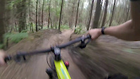
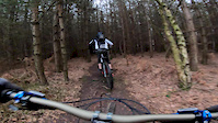
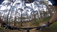
Videos of Bracknell Mountain Bike

trail: Bikini Line
0:07 |
|
Jan 14, 2025
trail: Bikini Line
0:06 |
257 |
Jan 14, 2025
trail: Babymaker
0:08 |
639 |
Aug 12, 2021
trail: Babymaker
0:07 |
955 |
Jun 16, 2020
trail: Babymaker
0:09 |
680 |
Jun 16, 2020
trail: Babymaker
0:12 |
841 |
Jun 16, 2020
trail: Red 9
4:52 |
1468 |
Feb 17, 2019
trail: Blue 12
0:41 |
1290 |
Oct 20, 2017
Recent Trail Reports
| status | trail | date | condition | info | user |
|---|---|---|---|---|---|
| Blue 8 | May 25, 2026 @ 1:50am (Australia/Brisbane) May 24, 2026 | Dry | sneezing7 | ||
| Red 13 | May 25, 2026 @ 1:44am (Australia/Brisbane) May 24, 2026 | Very Dry | sneezing7 | ||
| Red 7 | May 25, 2026 @ 1:43am (Australia/Brisbane) May 24, 2026 | Very Dry | sneezing7 | ||
| Bikini Line | Apr 7, 2026 @ 6:06am (Australia/Brisbane) Apr 6, 2026 | Ideal | al-smith67 | ||
| Blue 12 | Apr 6, 2026 @ 2:14pm (Europe/London) Apr 6, 2026 | Dry | irishcornelius | ||
| Blue 11 | Apr 6, 2026 @ 2:14pm (Europe/London) Apr 6, 2026 | Dry | irishcornelius | ||
| Blue 10 | Apr 6, 2026 @ 2:14pm (Europe/London) Apr 6, 2026 | Dry | irishcornelius | ||
| Blue 9 | Apr 6, 2026 @ 2:14pm (Europe/London) Apr 6, 2026 | Dry | irishcornelius | ||
| Access Road to Blue 9 | Apr 6, 2026 @ 2:14pm (Europe/London) Apr 6, 2026 | Dry | irishcornelius | ||
| Red 6 | Apr 6, 2026 @ 2:14pm (Europe/London) Apr 6, 2026 | Dry | irishcornelius |
Activity Feed
| username | action | type | title | date |
|---|---|---|---|---|
| Edward7gQFYV | wishlist | route | activity #96542353 | Jun 8, 2026 @ 8:46am Jun 8, 2026 |
| Simon8ikKZG | wishlist | route | activity #96405859 | Jun 6, 2026 @ 2:18pm Jun 6, 2026 |
| JosephMu | vote | trail | activity #95766948 | May 29, 2026 @ 4:22am May 29, 2026 |
| sneezing7 | vote | trail | activity #95414697 | May 24, 2026 @ 8:47am May 24, 2026 |
| sneezing7 | add | report | activity #95414334 and 2 more | May 24, 2026 @ 8:43am May 24, 2026 |
Recent Comments
| username | type | title | comment | date |
|---|---|---|---|---|
| trail | It's closed ! | Sep 25, 2025 @ 6:43am Sep 25, 2025 | ||
| report | Trail reopened today. Ground conditions are... | Sep 13, 2025 @ 12:09pm Sep 13, 2025 | ||
| trail | It's open ! | Sep 13, 2025 @ 10:02am Sep 13, 2025 | ||
| report | Closed | Jul 24, 2025 @ 6:47am Jul 24, 2025 | ||
| trail | Little more than a flat track back to the start | Jul 19, 2025 @ 1:00am Jul 19, 2025 |
Local Badges
-

Epic Ride Climb 2k9 awarded -

Climbing 10k Badge116 awarded -

Climbing 100k Badge4 awarded -

Epic Ride Descent 2k9 awarded -

Descent 10k Badge116 awarded -

Descent 100k Badge4 awarded
Bike & Skill Parks
| name | type | city | rating |
|---|---|---|---|
| Wargrave BMX Track | skill park | Bracknell |
Activity Type Stats
| activitytype | trails | distance | descent | descent distance | total vertical | rating | global rank | state rank | photos | reports | routes | ridelogs |
|---|---|---|---|---|---|---|---|---|---|---|---|---|
| Mountain Bike | 75 | 27 miles | 2,090 ft | 13 miles | 213 ft | #152 | #5 | 486 | 3,441 | 8 | 34,873 | |
| E-Bike | 69 | 25 miles | 1,772 ft | 12 miles | 213 ft | #799 | #42 | 3,111 | 2 | 3,965 | ||
| Horse | 9 | 9 miles | 538 ft | 6 miles | 197 ft | #1,092 | #51 | 926 | 1 | |||
| Hike | 23 | 14 miles | 712 ft | 8 miles | 203 ft | #5,980 | #146 | 2,976 | 145 | |||
| Trail Running | 23 | 14 miles | 712 ft | 8 miles | 203 ft | #5,371 | #130 | 2,976 | 878 | |||
| Dirtbike/Moto | 4 | 1,722 ft | 82 ft | 1,450 ft | 98 ft | #425 | #6 | 925 |
Frequently Asked Questions About Bracknell
▼
What are the best places to ride in Bracknell?
Bracknell has 2 areas to explore for mountain biking. The top rated areas are:
▼
What are the highest rated mountain biking trails in Bracknell?
The highest rated mountain biking trails in Bracknell are:
- Red 9 (4.7/5)
- Berminator (4.5/5)
- Deerstalker (4.4/5)
- Red 13 (4.3/5)
- Blue 12 (4.3/5)
▼
What is the best time of the year to ride in Bracknell?
Based on ride log data, the most popular months to ride in Bracknell are:
- July (171 activities)
- August (159 activities)
- June (153 activities)
▼
Where can I park to ride in Bracknell?
There are 1 parking locations listed in Bracknell. The most popular parking spots are:
Activities
Trails
Points of Interest
- By sk82jack & contributors
- Admins: wisey, MathieuC, cemoorelife, TTS
- #3700 - 9,925 views
- bracknell activity log | embed map of Bracknell mountain bike trails | bracknell mountain biking points of interest
Downloading of trail gps tracks in kml & gpx formats is enabled for Bracknell.
You must login to download files.