close
-
Layers w
- Weather Layers
- Pro
- Pro
- Pro
- Pro
- Pro
- Pro
- More Layers
- Pro
- Pro
- Pro
- Pro
-
Upgrade to

3D
Trail Conditions
- Unknown
- Snow Groomed
- Snow Packed
- Snow Covered
- Snow Cover Partial
- Freeze/thaw Cycle
- Icy
- Prevalent Mud
- Wet
- Variable
- Ideal
- Dry
- Very Dry
Trail Flow (Ridden Direction)
Trailforks scans users ridelogs to determine the most popular direction each trail is ridden. A good flowing trail network will have most trails flowing in a single direction according to their intension.
The colour categories are based on what percentage of riders are riding a trail in its intended direction.
The colour categories are based on what percentage of riders are riding a trail in its intended direction.
- > 96%
- > 90%
- > 80%
- > 70%
- > 50%
- < 50%
- bi-directional trail
- no data
Trail Last Ridden
Trailforks scans ridelogs to determine the last time a trail was ridden.
- < 2 days
- < 1 week
- < 2 weeks
- < 1 month
- < 6 months
- > 6 months
Trail Ridden Direction
The intended direction a trail should be ridden.
- Downhill Only
- Downhill Primary
- Both Directions
- Uphill Primary
- Uphill Only
- One Direction
Contribute Details
Colors indicate trail is missing specified detail.
- Description
- Photos
- Description & Photos
- Videos
Trail Popularity ?
Trailforks scans ridelogs to determine which trails are ridden the most in the last 9 months.
Trails are compared with nearby trails in the same city region with a possible 25 colour shades.
Think of this as a heatmap, more rides = more kinetic energy = warmer colors.
- most popular
- popular
- less popular
- not popular
ATV/ORV/OHV Filter
Max Vehicle Width
inches
US Cell Coverage
Legend

Radar Time
Activity Recordings
Trailforks uses anonymized public activity data.
?
Activity Recordings
Trailforks uses anonymized public activity data.
?
Personal Heatmap
▶
Activity Types
all
/
none
▶
Options
2
Date range
month
–
Winter Trails
Warning
A routing network for winter maps does not exist. Selecting trails using the winter trails layer has been disabled.
Missing Trails
Most Popular
Least Popular
Trails are colored based on popularity. The more popular a trail is, the more red. Less popular trails trend towards green.
Jump Magnitude Heatmap
Heatmap of where riders jump on trails. Zoom in to see individual jumps, click circles to view jump details.
BC Backroad Status
![map legend]()
Service Road Atlas is a free to use, community-driven service for viewing and creating reports on the numerous back-country service roads around B.C. and Alberta.

Slope Aspect
Direction the slope faces
Trails Deemphasized
Trails are shown in grey.
Only show trails with no bike usage.
Suggested Layers
Based on selected activity type
Save the current map location and zoom level as your default home location whenever this page is loaded.
SaveA network of trails on private land.
Primary Trail Type: Cross-Country
eBikes Allowed:
Yes
Land Status: Private Property
Activities Click to view
- Mountain Bike
46 trails
- E-Bike
22 trails
- Adaptive Bike
0 trails
- Winter Fat Bike
0 trails
- Hike
49 trails
- Trail Running
49 trails
Region Details
- 2
- 5
- 21
- 17
Region Status
Open as of Oct 23, 2025Stats
- Avg Trail Rating
- Trails (view details)
- 45
- Trails Mountain Bike
- 50
- Trails E-Bike
- 22
- Trails Hike
- 49
- Trails Trail Running
- 49
- Trails Backcountry Ski
- 2
- Trails Nordic Ski
- 2
- Total Distance
- 20 miles
- Total Descent
- 4,258 ft
- Total Vertical
- 283 ft
- Highest Trailhead
- 3,063 ft
- Reports
- 94
- Photos
- 121
- Ridden Counter
- 772
Sub Regions
-
Potter's Pasture
- 5
- 21
- 17
Popular Brady Mountain Biking Trails
• 95 ★ 4.5 • 2,913 ft • 194 ft • 35 •
Popular black diamond difficulty singletrack. This mountain bike primary trail can be used downhill primary. It features ladder bridge. On average it takes 10 minutes to complete this trail.
• 75 ★ 0.0 • 1,230 ft • 33 ft • 34 •
Popular blue difficulty singletrack. This mountain bike primary trail can be used both directions. On average it takes 2 minutes to complete this trail.
• 60 ★ 0.0 • 1 mile • 155 ft • 30 •
Moderately popular black diamond difficulty singletrack. This mountain bike primary trail can be used both directions. On average it takes 12 minutes to complete this trail.
• 80 ★ 0.0 • 926 ft • 2 ft • 30 •
Popular blue difficulty singletrack. This mountain bike primary trail can be used both directions and has a moderate overall physical rating with a 2 ft blue climb. On average it takes 1 minutes to complete this trail.
• 70 ★ 0.0 • 4,627 ft • 0 ft • 29 •
Popular green difficulty singletrack. This mountain bike primary trail can be used both directions. On average it takes 4 minutes to complete this trail.
• 40 ★ 0.0 • 2,900 ft • 114 ft • 27 •
Moderately popular blue difficulty singletrack. This mountain bike primary trail. On average it takes 5 minutes to complete this trail.
• 45 ★ 0.0 • 2,175 ft • 14 ft • 26 •
Moderately popular blue difficulty singletrack. This mountain bike primary trail can be used both directions and has a hard overall physical rating with a 14 ft black diamond climb. On average it takes 6 minutes to complete this trail.
• 85 ★ 0.0 • 1 mile • 103 ft • 24 •
Popular blue difficulty singletrack. This mountain bike primary trail can be used both directions. On average it takes 15 minutes to complete this trail.
Brady Mountain Bike Routes
9 miles • 1,052 ft • 5 •
this is an 8 mile route in potter pasture, that includes most of the best trails, and keeps you from...
Photos of Brady Mountain Bike
Videos of Brady Mountain Bike
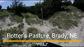
trail: PB&J
0:37 |
44 |
Aug 23, 2025 , Brady
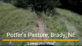
trail: Lower Hornitos
5:07 |
49 |
Aug 18, 2025 , Brady
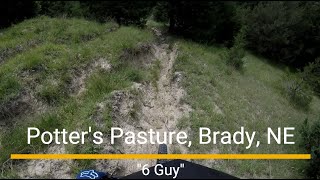
trail: 6 Guy
2:26 |
41 |
Aug 18, 2025 , Brady
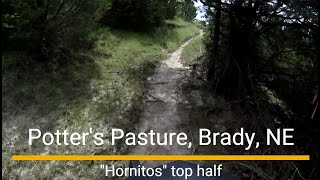
trail: Hornitos
3:25 |
37 |
Aug 18, 2025 , Brady
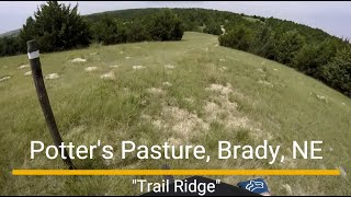
trail: Trail Ridge
2:56 |
46 |
Aug 18, 2025 , Brady

trail: Wicked Ridge
854 |
Sep 23, 2017 , Brady
Recent Trail Reports
| status | trail | date | condition | info | user |
|---|---|---|---|---|---|
| Lower Hornitos | Jul 29, 2025 @ 12:15pm Jul 29, 2025 | Unknown | ryechard | ||
| Hornitos | Jul 29, 2025 @ 12:15pm Jul 29, 2025 | Dry | ryechard | ||
| South Trail Ridge | Jul 29, 2025 @ 12:15pm Jul 29, 2025 | Ideal | ryechard | ||
| PB&J | Jul 29, 2025 @ 12:15pm Jul 29, 2025 | Dry | ryechard | ||
| The Desert | Jan 1, 2025 @ 3:14pm Jan 1, 2025 | Dry | NickNZzp3 | ||
| Freeway (South) | Jan 1, 2025 @ 3:14pm Jan 1, 2025 | Ideal | NickNZzp3 | ||
| Church Grove | Jan 1, 2025 @ 3:14pm Jan 1, 2025 | Dry | NickNZzp3 | ||
| Diamonds Aren't Forever | Jan 1, 2025 @ 3:14pm Jan 1, 2025 | Ideal | NickNZzp3 | ||
| Starbucks | Jan 1, 2025 @ 3:14pm Jan 1, 2025 | Ideal | NickNZzp3 | ||
| Wicked Ridge | Jan 1, 2025 @ 3:14pm Jan 1, 2025 | Ideal | NickNZzp3 |
Activity Feed
| username | action | type | title | date |
|---|---|---|---|---|
| TinaXG | ridden | trail | activity #82877257 and 2 more | Oct 23, 2025 @ 10:07am Oct 23, 2025 |
| TinaXG | vote | trail | activity #82877242 | Oct 23, 2025 @ 10:06am Oct 23, 2025 |
| ryechard | add | video | activity #78785057 | Aug 23, 2025 @ 2:56pm Aug 23, 2025 |
| ryechard | add | video | activity #78444746 | Aug 18, 2025 @ 5:27pm Aug 18, 2025 |
| ryechard | add | photo | activity #78441801 and 11 more | Aug 18, 2025 @ 4:40pm Aug 18, 2025 |
Recent Comments
| username | type | title | comment | date |
|---|---|---|---|---|
| trail | We weren’t sure what to think after starting... | Oct 10, 2022 @ 11:00am Oct 10, 2022 | ||
| trail | Interesting riding area, mixture of double... | Oct 10, 2022 @ 10:58am Oct 10, 2022 | ||
| trail | Many of the trails at Potters are cow paths.... | Dec 7, 2020 @ 8:24pm Dec 7, 2020 | ||
| report | Between the waterfalls on pre-road apples? | Nov 28, 2019 @ 9:53am Nov 28, 2019 | ||
| trail | Fairly easy trail, but mostly a cow path. | Sep 4, 2019 @ 11:13am Sep 4, 2019 |
Local Badges
-

10 Blue Trails2 awarded -

Epic Ride Climb 2k0 awarded -

Climbing 10k Badge2 awarded -

Climbing 100k Badge0 awarded -

Epic Ride Descent 2k0 awarded -

Descent 10k Badge2 awarded
Activity Type Stats
| activitytype | trails | distance | descent | descent distance | total vertical | rating | global rank | state rank | photos | reports | routes | ridelogs |
|---|---|---|---|---|---|---|---|---|---|---|---|---|
| Mountain Bike | 46 | 20 miles | 4,259 ft | 11 miles | 282 ft | #4,222 | #1,422 | 121 | 94 | 404 | ||
| E-Bike | 22 | 7 miles | 1,834 ft | 4 miles | 272 ft | #7,492 | #2,259 | 82 | 19 | |||
| Hike | 49 | 20 miles | 4,081 ft | 11 miles | 282 ft | #7,519 | #2,668 | 90 | 8 | |||
| Trail Running | 49 | 20 miles | 4,081 ft | 11 miles | 282 ft | #6,985 | #2,304 | 90 | 4 | |||
| Backcountry Ski | 2 | 2,031 ft | 131 ft | 2,031 ft | 197 ft | |||||||
| Nordic Ski | 2 | 2,031 ft | 131 ft | 2,031 ft | 197 ft |
Frequently Asked Questions About Brady
▼
What are the best places to ride in Brady?
Brady has 1 areas to explore for mountain biking. The top rated areas are:
▼
What are the highest rated mountain biking trails in Brady?
The highest rated mountain biking trails in Brady are:
- Betsy's (4.1/5)
- Wicked Ridge (4.1/5)
- First Way (4/5)
- Crack-a-Lacken (4/5)
- Church Grove (0/5)
▼
What is the best time of the year to ride in Brady?
Based on ride log data, the most popular months to ride in Brady are:
- July (11 activities)
- May (6 activities)
- September (5 activities)
▼
Where can I park to ride in Brady?
There are 2 parking locations listed in Brady. The most popular parking spots are:
Activities
Trails
- By cpobanz
 & contributors
 - Admins: apply
- #20080 - 1,928 views
- brady activity log | embed map of Brady mountain bike trails | brady mountain biking points of interest
Downloading of trail gps tracks in kml & gpx formats is enabled for Brady.
You must login to download files.