close
-
Layers w
- Weather Layers
- Pro
- Pro
- Pro
- Pro
- Pro
- Pro
- More Layers
- Pro
- Pro
- Pro
- Pro
-
Upgrade to

3D
Trail Conditions
- Unknown
- Snow Groomed
- Snow Packed
- Snow Covered
- Snow Cover Partial
- Freeze/thaw Cycle
- Icy
- Prevalent Mud
- Wet
- Variable
- Ideal
- Dry
- Very Dry
Trail Flow (Ridden Direction)
Trailforks scans users ridelogs to determine the most popular direction each trail is ridden. A good flowing trail network will have most trails flowing in a single direction according to their intension.
The colour categories are based on what percentage of riders are riding a trail in its intended direction.
The colour categories are based on what percentage of riders are riding a trail in its intended direction.
- > 96%
- > 90%
- > 80%
- > 70%
- > 50%
- < 50%
- bi-directional trail
- no data
Trail Last Ridden
Trailforks scans ridelogs to determine the last time a trail was ridden.
- < 2 days
- < 1 week
- < 2 weeks
- < 1 month
- < 6 months
- > 6 months
Trail Ridden Direction
The intended direction a trail should be ridden.
- Downhill Only
- Downhill Primary
- Both Directions
- Uphill Primary
- Uphill Only
- One Direction
Contribute Details
Colors indicate trail is missing specified detail.
- Description
- Photos
- Description & Photos
- Videos
Trail Popularity ?
Trailforks scans ridelogs to determine which trails are ridden the most in the last 9 months.
Trails are compared with nearby trails in the same city region with a possible 25 colour shades.
Think of this as a heatmap, more rides = more kinetic energy = warmer colors.
- most popular
- popular
- less popular
- not popular
ATV/ORV/OHV Filter
Max Vehicle Width
inches
US Cell Coverage
Legend

Radar Time
Activity Recordings
Trailforks uses anonymized public activity data.
?
Activity Recordings
Trailforks uses anonymized public activity data.
?
Personal Heatmap
▶
Activity Types
all
/
none
▶
Options
2
Date range
month
–
Winter Trails
Warning
A routing network for winter maps does not exist. Selecting trails using the winter trails layer has been disabled.
Missing Trails
Most Popular
Least Popular
Trails are colored based on popularity. The more popular a trail is, the more red. Less popular trails trend towards green.
Jump Magnitude Heatmap
Heatmap of where riders jump on trails. Zoom in to see individual jumps, click circles to view jump details.
BC Backroad Status
![map legend]()
Service Road Atlas is a free to use, community-driven service for viewing and creating reports on the numerous back-country service roads around B.C. and Alberta.

Slope Aspect
Direction the slope faces
Trails Deemphasized
Trails are shown in grey.
Only show trails with no bike usage.
Suggested Layers
Based on selected activity type
Save the current map location and zoom level as your default home location whenever this page is loaded.
Save
No description for Branson has been added yet!
Login or register to submit one.
Activities Click to view
- Mountain Bike
30 trails
- E-Bike
13 trails
- Adaptive Bike
0 trails
- Hike
35 trails
- Trail Running
35 trails
Region Details
- 3
- 2
- 3
- 13
- 4
- 3
Region Status
Open as of Apr 20, 2026Stats
- Avg Trail Rating
- Trails (view details)
- 43
- Trails Mountain Bike
- 30
- Trails E-Bike
- 13
- Trails Hike
- 35
- Trails Trail Running
- 35
- Total Distance
- 52 miles
- Total Descent Distance
- 23 miles
- Total Descent
- 6,701 ft
- Total Vertical
- 642 ft
- Highest Trailhead
- 1,375 ft
- Reports
- 165
- Photos
- 56
- Ridden Counter
- 5,915
Sub Regions
-
Howler Bike Park
- 3
- 3
- 2
- 3
-
Shepherd of the Hills Fish Hatchery
- 2
-
White River Trails @ Table Rock State Park
- 1
- 12
- 2
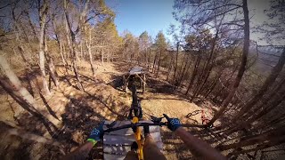
Popular Branson Mountain Biking Trails
• 90 ★ 5.0 • 4,003 ft • 0 ft • 426 •
A flow trail with numerous berms and jumps composed of a shaley soil
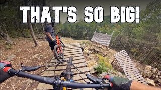
• 75 ★ 4.5 • 2,874 ft • 0 ft • 409 •
We decided to take the phrase 'Party Laps', and build the perfect blue jump-line to fit.
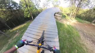
• 65 ★ 4.0 • 1 mile • 0 ft • 385 •
Intro to mountain biking? Warm-up run? You decide. Stroller-coaster is our longest trail in the park with stunning views and an experience great for all skill levels.
• 80 ★ 4.5 • 784 ft • 0 ft • 384 •
Missuori's rock is no joke, so we allowed mother nature to do most of the work on this white-knuckle tech.
• 95 ★ 4.0 • 843 ft • 0 ft • 273 •
Popular black diamond difficulty singletrack. This mountain bike primary trail can be used downhill only. Trail visibility is always easy to follow. On average it takes 3 minutes to complete this trail.
• 50 ★ 5.0 • 951 ft • 0 ft • 256 •
features a steep wooden jump, and the links into a few table tops and berms before merging with and .
• 80 ★ 4.0 • 1 mile • 149 ft • 236 •
This is half of the Red loop. This trail arguably flows better starting at the trailhead right off 265 and ridden CW. Has a fun flowing section that's relatively flat in the creek bottom, and then a climb out of the valley that's not...
Branson Mountain Bike Routes
15 miles • 1,505 ft • 28 • Race •
White River Valley Missouri Enduro Series Race No roads option 2 stage 1 can be split in two.
15 miles • 1,582 ft • 29 • Race •
White River Valley Missouri Enduro Series Race option one
13 miles • 1,164 ft • 25 • Loop • Race •
Potential map for the MES WRV enduro. Stage 4 is pretty short and can be cut if needed.
10 miles • 1,064 ft • 10 • Point to Point • Race •
Race Course for White River Enduro, stop #4 on the Missouri Enduro Series (MES)
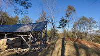
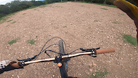
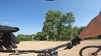
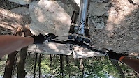
Photos of Branson Mountain Bike
Videos of Branson Mountain Bike
trail: Taco Cat-A
0:07 |
91 |
Feb 5, 2024
trail: Mustard Tiger
0:28 |
165 |
Sep 9, 2022
trail: Mustard Tiger
2:07 |
156 |
Jun 29, 2022
trail: Momo
2:21 |
156 |
Jun 29, 2022
trail: Wizard
27:31 |
483 |
Feb 5, 2024 , Branson
0:26 |
186 |
Nov 6, 2023
trail: Taco Cat-A
0:46 |
323 |
Nov 6, 2023 , Branson
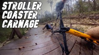
trail: Stroller Coaster
3:26 |
272 |
Nov 6, 2023 , Branson
Recent Trail Reports
| status | trail | date | condition | info | user |
|---|---|---|---|---|---|
| Taco Cat-B | Apr 19, 2026 @ 11:19am (America/Chicago) Apr 19, 2026 | Wet | decoydude | ||
| Momo | Apr 19, 2026 @ 11:19am (America/Chicago) Apr 19, 2026 | Wet | decoydude | ||
| Mustard Tiger | Apr 19, 2026 @ 11:19am (America/Chicago) Apr 19, 2026 | Wet | decoydude | ||
| Swayze-Train | Apr 19, 2026 @ 11:19am (America/Chicago) Apr 19, 2026 | Wet | decoydude | ||
| Dirty Dancing | Apr 19, 2026 @ 11:19am (America/Chicago) Apr 19, 2026 | Wet | decoydude | ||
| Hippie Cowboy | Apr 19, 2026 @ 11:19am (America/Chicago) Apr 19, 2026 | Wet | decoydude | ||
| WC4 | Mar 25, 2026 @ 11:52am (America/Indiana/Vincennes) Mar 25, 2026 | Variable | jer091 CRAMBA | ||
| WC2 Bypass | Mar 25, 2026 @ 11:52am (America/Indiana/Vincennes) Mar 25, 2026 | Variable | jer091 CRAMBA | ||
| Technical Line 2 | Mar 25, 2026 @ 11:52am (America/Indiana/Vincennes) Mar 25, 2026 | Variable | jer091 CRAMBA | ||
| Red Loop (West) | Mar 25, 2026 @ 11:52am (America/Indiana/Vincennes) Mar 25, 2026 | Variable | jer091 CRAMBA |
Activity Feed
| username | action | type | title | date |
|---|---|---|---|---|
| Daniella2ndt | wishlist | route | activity #95229682 | May 22, 2026 @ 2:49am May 22, 2026 |
| jscotts | wishlist | region | activity #94943148 | May 17, 2026 @ 2:59pm May 17, 2026 |
| Nimrodz28 | wishlist | region | activity #94470717 | May 10, 2026 @ 5:30pm May 10, 2026 |
| Bret-300 | wishlist | route | activity #94170400 | May 6, 2026 @ 12:01pm May 6, 2026 |
| ilv2srf | wishlist | region | activity #93931025 | May 3, 2026 @ 3:47am May 3, 2026 |
Recent Comments
| username | type | title | comment | date |
|---|---|---|---|---|
| trail | I’m a 60-year-old intermediate writer and... | Nov 15, 2025 @ 8:21am Nov 15, 2025 | ||
| trail | Rode CW. Enjoyable trail. | Aug 4, 2024 @ 7:26am Aug 4, 2024 | ||
| trail | Also ride this trail counter clockwise (... | Jul 3, 2024 @ 7:40am Jul 3, 2024 | ||
| trail | Fun flow/jump line. Conditions need to be good... | Dec 30, 2023 @ 7:28am Dec 30, 2023 | ||
| trail | Good trail for kids but otherwise boring... | Dec 30, 2023 @ 7:27am Dec 30, 2023 |
Local Badges
-

Epic Mountain Bike Climb 2k14 awarded -

Climbing 10k Badge7 awarded -

Mountain Biking 100k Badge0 awarded -

Epic Ride Descent 2k14 awarded -

Descent 10k Badge7 awarded -

Descent 100k Badge0 awarded
Bike & Skill Parks
| name | type | city | rating |
|---|---|---|---|
| Howler Bike Park | bike park | Branson |
Activity Type Stats
| activitytype | trails | distance | descent | descent distance | total vertical | rating | global rank | state rank | photos | reports | routes | ridelogs |
|---|---|---|---|---|---|---|---|---|---|---|---|---|
| Mountain Bike | 30 | 18 miles | 3,094 ft | 8 miles | 597 ft | #2,907 | #1,029 | 47 | 165 | 3 | 2,349 | |
| E-Bike | 13 | 10 miles | 994 ft | 4 miles | 374 ft | #5,865 | #1,806 | 2 | 151 | 1 | 171 | |
| Hike | 35 | 46 miles | 4,747 ft | 19 miles | 643 ft | #4,554 | #1,607 | 3 | 158 | 1 | 204 | |
| Trail Running | 35 | 46 miles | 4,747 ft | 19 miles | 643 ft | #4,562 | #1,411 | 158 | 1 | 68 |
Frequently Asked Questions About Branson
▼
What are the best places to ride in Branson?
Branson has 4 areas to explore for mountain biking. The top rated areas are:
▼
What are the highest rated mountain biking trails in Branson?
The highest rated mountain biking trails in Branson are:
- Momo (4.2/5)
- Taco Cat-A (4.2/5)
- WC4 (4.1/5)
- WC2 (4.1/5)
- WC3 (4.1/5)
▼
What is the best time of the year to ride in Branson?
Based on ride log data, the most popular months to ride in Branson are:
- July (38 activities)
- June (27 activities)
- August (18 activities)
▼
Where can I park to ride in Branson?
There are 8 parking locations listed in Branson. The most popular parking spots are: View all parking and trailhead locations on the map to plan your visit.
Activities
Trails
Points of Interest
- By chuktA
 TRAILFORKS NFTA & contributors
 - Admins: MDC-SW, thomcerny
- #27222 - 8,052 views
- branson activity log | embed map of Branson mountain bike trails | branson mountain biking points of interest
Downloading of trail gps tracks in kml & gpx formats is enabled for Branson.
You must login to download files.