close
-
Layers w
- Weather Layers
- Pro
- Pro
- Pro
- Pro
- Pro
- Pro
- More Layers
- Pro
- Pro
- Pro
- Pro
-
Upgrade to

3D
Trail Conditions
- Unknown
- Snow Groomed
- Snow Packed
- Snow Covered
- Snow Cover Partial
- Freeze/thaw Cycle
- Icy
- Prevalent Mud
- Wet
- Variable
- Ideal
- Dry
- Very Dry
Trail Flow (Ridden Direction)
Trailforks scans users ridelogs to determine the most popular direction each trail is ridden. A good flowing trail network will have most trails flowing in a single direction according to their intension.
The colour categories are based on what percentage of riders are riding a trail in its intended direction.
The colour categories are based on what percentage of riders are riding a trail in its intended direction.
- > 96%
- > 90%
- > 80%
- > 70%
- > 50%
- < 50%
- bi-directional trail
- no data
Trail Last Ridden
Trailforks scans ridelogs to determine the last time a trail was ridden.
- < 2 days
- < 1 week
- < 2 weeks
- < 1 month
- < 6 months
- > 6 months
Trail Ridden Direction
The intended direction a trail should be ridden.
- Downhill Only
- Downhill Primary
- Both Directions
- Uphill Primary
- Uphill Only
- One Direction
Contribute Details
Colors indicate trail is missing specified detail.
- Description
- Photos
- Description & Photos
- Videos
Trail Popularity ?
Trailforks scans ridelogs to determine which trails are ridden the most in the last 9 months.
Trails are compared with nearby trails in the same city region with a possible 25 colour shades.
Think of this as a heatmap, more rides = more kinetic energy = warmer colors.
- most popular
- popular
- less popular
- not popular
ATV/ORV/OHV Filter
Max Vehicle Width
inches
US Cell Coverage
Legend

Radar Time
Activity Recordings
Trailforks uses anonymized public activity data.
?
Activity Recordings
Trailforks uses anonymized public activity data.
?
Personal Heatmap
▶
Activity Types
all
/
none
▶
Options
2
Date range
month
–
Winter Trails
Warning
A routing network for winter maps does not exist. Selecting trails using the winter trails layer has been disabled.
Missing Trails
Most Popular
Least Popular
Trails are colored based on popularity. The more popular a trail is, the more red. Less popular trails trend towards green.
Jump Magnitude Heatmap
Heatmap of where riders jump on trails. Zoom in to see individual jumps, click circles to view jump details.
BC Backroad Status
![map legend]()
Service Road Atlas is a free to use, community-driven service for viewing and creating reports on the numerous back-country service roads around B.C. and Alberta.

Slope Aspect
Direction the slope faces
Trails Deemphasized
Trails are shown in grey.
Only show trails with no bike usage.
Suggested Layers
Based on selected activity type
Save the current map location and zoom level as your default home location whenever this page is loaded.
SaveThis region is Unsanctioned, Ride at your own Risk!
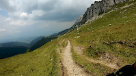
Brașov contains some of the most attractive tourist destinations in Romania.
The main tourist attractions in the county are:
The city of Brașov.
Poiana Brașov mountain resort.
Predeal mountain resort.
Bran with its castle often referred to as Dracula's castle.
The Făgăraș Mountains.
The medieval fortresses of Făgăraș and Râșnov.
The Fortified churches from the Saxon villages in the Burzenland area.
This region uses the Uk/Euro style trail grading system.
Region Details
- 241
- 1
- 136
- 72
- 36
- 38
- 2
Stats
- Avg Trail Rating
- Trails (view details)
- 533
- Trails Mountain Bike
- 535
- Trails E-Bike
- 499
- Trails Horse
- 95
- Trails Hike
- 492
- Trails Trail Running
- 488
- Trails Dirtbike/Moto
- 60
- Trails Observed Trials
- 18
- Trails ATV/ORV/OHV
- 65
- Trails Backcountry Ski
- 1
- Trails Nordic Ski
- 1
- Total Distance
- 1,052 miles
- Total Descent
- 242,869 ft
- Total Vertical
- 6,833 ft
- Highest Trailhead
- 8,202 ft
- Reports
- 4,840
- Photos
- 616
- Ridden Counter
- 22,863
Popular Trail Networks
view all areas »Sub Regions
- Beclean (5)
- Bradet (1)
- Bran (18)
- Brava Bike Park (2)
- Brasov (209)
- BikePark Postăvarul (16)
- Noua (10)
- Postăvaru (174)
- Buneşti (9)
- Codlea (6)
- Comana (1)
- Cristian (4)
- Crizbav (3)
- Dejani (2)
- Dragus (4)
- Dumbrăvița BV (2)
- Fagaras (3)
- Fundata (8)
- Hărman (5)
- Hârseni (8)
- Hoghiz (1)
- Holbav (10)
- Jibert (3)
- Lisa (2)
- Mesendorf (1)
- Moieciu (32)
- Podu Olt (3)
- Poiana Mărului (19)
- Predeal (18)
- Racoș (3)
- Râşnov (19)
- Glăjărie (5)
- Recea (3)
- Rupea (1)
- Săcele (56)
- Ciucaş (14)
- Piatra Mare (27)
- Sambata De Sus (3)
- Sânpetru (11)
- Lempes (9)
- Şercaia (4)
- Sinca Noua (4)
- Şoarş (3)
- Tărlungeni (10)
- Ticuşu (1)
- Timisu de Sus (1)
- Vama Buzăului (8)
- Victoria (1)
- Viștea (2)
- Voila (1)
- Vulcan (2)
- Zarnesti (24)
Popular Brasov Mountain Biking Trails
• 5 ★ 4.0 • 1,880 ft • 0 ft • 243 •
Easy alternative to the fire road. The trail has some a few sections with roots and a small drop that can be avoided.
• 100 ★ 4.6 • 2 miles • 48 ft • 211 •
Highly rated popular green difficulty singletrack. This mountain bike primary trail can be used both directions with a 48 ft green climb. On average it takes 13 minutes to complete this trail.
• 85 ★ 4.2 • 1 mile • 31 ft • 206 •
Flowy trail dedicated to Killy from Cabana SKV Postavarul, who has passed on recently. Expect big berms with tight turns.
• 75 ★ 4.4 • 3,182 ft • 0 ft • 191 •
The third part of the Flow line is . The rail has a lot of berms, small jumps, table tops and a big wooden bridge. All the jumps are safe and are very good to work on your progression.
• 40 ★ 4.5 • 3,750 ft • 0 ft • 173 •
The first trail from Postavarul Bike Park. Lots of technical elements in a relative short trail. Lots of fun though!
Brasov Mountain Bike Routes
29 miles • 2,346 ft • 3 • Point to Point •
One of the most attractive MTB tracks in Transylvania
9 miles • 968 ft • 7 •
A really nice trail, the easy way to get back to Racadau
12 miles • 2,363 ft • 6 • Loop •
One of the classic bike loops around Brasov. You climb up the fireroad until Poiana Brasov, then descens...
27 miles • 4,720 ft • 19 • Loop •
Traseu nr 5 https://www.pcrai.ro/trasee-bicicleta Traseu dificil din cauza diferentei de nivel. Din...
6 miles • 1,345 ft • 2 •
Approximate trail route usually used for Semimaraton Intersport Training.
7 miles • 1,534 ft • 0 • Out & Back •
One of the oldest trails in Brasov, the yellow triangle is a trail that descends you back into the city...
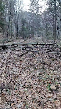
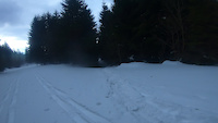
Photos of Brasov Mountain Bike
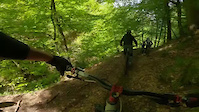
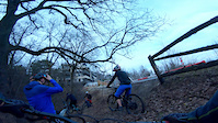
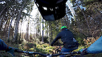
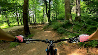
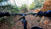
Videos of Brasov Mountain Bike
trail: Legs day
0:09 |
123 |
Feb 19, 2024
trail: Tamina - Saua Pietricica
0:09 |
51 |
Feb 19, 2022
trail: Potecuţă (direct)
0:21 |
245 |
May 28, 2021
trail: Canal
2:33 |
128 |
Apr 7, 2021
trail: Putreda
5:56 |
101 |
Jan 2, 2020
trail: Şaua Strunga - Guţanu
11:18 |
168 |
Aug 5, 2019
trail: Potecuţă (direct)
3:54 |
343 |
Jun 26, 2019
trail: Crucuri
3:37 |
313 |
Mar 25, 2019
Current Trail Warnings
| status | trail | date | condition | user | info |
|---|---|---|---|---|---|
| Tobogan Postăvaru | Jun 18, 2026 @ 5:29pm (Europe/Bucharest) 2 days | Ideal | aWXsTn9i | ||
| Bazine Postăvaru | May 26, 2026 @ 7:09pm (Europe/Bucharest) May 26, 2026 | Ideal | wcSIUj | Tree fallen on the trail. There’s one... |
Recent Trail Reports
Activity Feed
| username | action | type | title | date |
|---|---|---|---|---|
| Vanboghy | add | report | activity #97332308 and 1 more | Jun 19, 2026 @ 11:21am 12 hours |
| Vanboghy | add | report | activity #97332306 and 3 more | Jun 19, 2026 @ 11:21am 12 hours |
| aWXsTn9i | add | report | activity #97299482 and 1 more | Jun 18, 2026 @ 11:33pm 24 hours |
| 3sixtee | add | report | activity #97262273 and 9 more | Jun 18, 2026 @ 10:41am 2 days |
| edie9p6ZzA | ridden | trail | activity #97261481 and 1 more | Jun 18, 2026 @ 10:28am 2 days |
Recent Comments
| username | type | title | comment | date |
|---|---|---|---|---|
| report | Bună. Care ar fi un traseu ideal și pentru... | May 30, 2026 @ 9:47pm May 30, 2026 | ||
| report | Mă puteți ajuta și pentru un traseu ideal... | May 30, 2026 @ 9:46pm May 30, 2026 | ||
| trail | Lake absolutely rips. In 307 meters you... | Apr 13, 2026 @ 6:00am Apr 13, 2026 | ||
| trail | Too many fallen trees | Mar 20, 2026 @ 4:53am Mar 20, 2026 | ||
| report | it will be dealt with. | Feb 16, 2026 @ 7:12am Feb 16, 2026 |
Local Badges
-

Epic Ride 50k17 awarded -

10 Green Trails92 awarded -
Epic Ride 50k17 awarded -
10 Green Trails2 awarded -
Epic Ride 50k20 awarded -
Epic Ride 50k20 awarded
Bike & Skill Parks
| name | type | city | rating |
|---|---|---|---|
| BikePark Postăvarul | bike park | Brasov | |
| Pump track Dealul Melcilor | skill park | Brasov | |
| NH Bike Park | skill park | Brasov | |
| Pumptrack Coresi | skill park | Brasov | |
| Small skatepark | skill park | Brasov |
Activity Type Stats
| activitytype | trails | distance | descent | descent distance | total vertical | rating | global rank | state rank | photos | reports | routes | ridelogs |
|---|---|---|---|---|---|---|---|---|---|---|---|---|
| Mountain Bike | 533 | 1,046 miles | 238,894 ft | 489 miles | 6,834 ft | 540 | 4,839 | 11 | 26,116 | |||
| E-Bike | 499 | 971 miles | 229,370 ft | 464 miles | 6,834 ft | 74 | 4,807 | 12 | 8,716 | |||
| Horse | 95 | 338 miles | 41,079 ft | 141 miles | 4,393 ft | 49 | ||||||
| Hike | 492 | 969 miles | 219,272 ft | 444 miles | 6,834 ft | 5 | 4,637 | 2 | 4,859 | |||
| Trail Running | 488 | 971 miles | 218,914 ft | 446 miles | 6,834 ft | 1 | 4,630 | 2 | 1,864 | |||
| Dirtbike/Moto | 60 | 240 miles | 26,844 ft | 97 miles | 4,518 ft | 43 | 5 | |||||
| Observed Trials | 18 | 90 miles | 7,953 ft | 29 miles | 3,192 ft | 16 | 2 | |||||
| ATV/ORV/OHV | 65 | 268 miles | 30,581 ft | 113 miles | 4,324 ft | 41 | 4 | |||||
| Backcountry Ski | 1 | 12 miles | 3,114 ft | 7 miles | 2,831 ft | 966 | ||||||
| Nordic Ski | 1 | 1,526 ft | 397 ft | 1,519 ft | 397 ft | 1 | 314 |
Activities
Trails
- By punksovereign & contributors
- Admins: pufalot, zbangee
- #6379 - 18,902 views
- brasov activity log | embed map of Brasov mountain bike trails | brasov mountain biking points of interest
Downloading of trail gps tracks in kml & gpx formats is enabled for Brasov.
You must login to download files.