close
-
Layers w
- Weather Layers
- Pro
- Pro
- Pro
- Pro
- Pro
- Pro
- More Layers
- Pro
- Pro
- Pro
- Pro
-
Upgrade to

3D
Trail Conditions
- Unknown
- Snow Groomed
- Snow Packed
- Snow Covered
- Snow Cover Partial
- Freeze/thaw Cycle
- Icy
- Prevalent Mud
- Wet
- Variable
- Ideal
- Dry
- Very Dry
Trail Flow (Ridden Direction)
Trailforks scans users ridelogs to determine the most popular direction each trail is ridden. A good flowing trail network will have most trails flowing in a single direction according to their intension.
The colour categories are based on what percentage of riders are riding a trail in its intended direction.
The colour categories are based on what percentage of riders are riding a trail in its intended direction.
- > 96%
- > 90%
- > 80%
- > 70%
- > 50%
- < 50%
- bi-directional trail
- no data
Trail Last Ridden
Trailforks scans ridelogs to determine the last time a trail was ridden.
- < 2 days
- < 1 week
- < 2 weeks
- < 1 month
- < 6 months
- > 6 months
Trail Ridden Direction
The intended direction a trail should be ridden.
- Downhill Only
- Downhill Primary
- Both Directions
- Uphill Primary
- Uphill Only
- One Direction
Contribute Details
Colors indicate trail is missing specified detail.
- Description
- Photos
- Description & Photos
- Videos
Trail Popularity ?
Trailforks scans ridelogs to determine which trails are ridden the most in the last 9 months.
Trails are compared with nearby trails in the same city region with a possible 25 colour shades.
Think of this as a heatmap, more rides = more kinetic energy = warmer colors.
- most popular
- popular
- less popular
- not popular
ATV/ORV/OHV Filter
Max Vehicle Width
inches
US Cell Coverage
Legend

Radar Time
Activity Recordings
Trailforks uses anonymized public activity data.
?
Activity Recordings
Trailforks uses anonymized public activity data.
?
Personal Heatmap
▶
Activity Types
all
/
none
▶
Options
2
Date range
month
–
Winter Trails
Warning
A routing network for winter maps does not exist. Selecting trails using the winter trails layer has been disabled.
Missing Trails
Most Popular
Least Popular
Trails are colored based on popularity. The more popular a trail is, the more red. Less popular trails trend towards green.
Jump Magnitude Heatmap
Heatmap of where riders jump on trails. Zoom in to see individual jumps, click circles to view jump details.
BC Backroad Status
![map legend]()
Service Road Atlas is a free to use, community-driven service for viewing and creating reports on the numerous back-country service roads around B.C. and Alberta.

Slope Aspect
Direction the slope faces
Trails Deemphasized
Trails are shown in grey.
Only show trails with no bike usage.
Suggested Layers
Based on selected activity type
Save the current map location and zoom level as your default home location whenever this page is loaded.
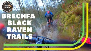
SaveThe Gorlech Trail, designed by Rowan Sorrell, is made up of three big climbs and descents stretching over its 19km.
More progressive riders can also test their full arsenal of skills on the fearsome but thrilling features of the black graded Raven Trail
In contrast, the Derwen Trail is the starting point for families and novices and a great introduction to mountain biking.
All trails show off Brechfa Forest at its best.
 google parking directions
This region uses the Uk/Euro style trail grading system.
Activities Click to view
- Mountain Bike
3 trails
- E-Bike
1 trails
- Hike
2 trails
- Trail Running
2 trails
Region Details
- 1
- 1
- 1
Region Status
Caution as of Aug 20, 2025Stats
- Avg Trail Rating
- Trails (view details)
- 3
- Trails Mountain Bike
- 3
- Trails E-Bike
- 1
- Trails Hike
- 2
- Trails Trail Running
- 2
- Total Distance
- 27 miles
- Total Descent
- 5,422 ft
- Total Vertical
- 774 ft
- Highest Trailhead
- 1,061 ft
- Reports
- 61
- Photos
- 104
- Ridden Counter
- 714
Popular Brechfa Forest Mountain Biking Trails
• 35 ★ 3.1 • 11 miles • 2,239 ft • 196 •
Less popular black difficulty singletrack. This mountain bike primary trail. On average it takes 1 hour50 minutes to complete this trail.
• 100 ★ 4.0 • 4 miles • 550 ft • 150 •
Popular green difficulty singletrack. This mountain bike primary trail. On average it takes 28 minutes to complete this trail.
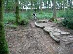
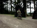
Photos of Brechfa Forest Mountain Bike
Videos of Brechfa Forest Mountain Bike
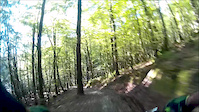
trail: Raven Trail
3:20 |
301 |
Oct 5, 2015
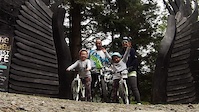
trail: Derwen Trail
8:43 |
287 |
May 26, 2015
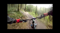
trail: Raven Trail
7:59 |
488 |
Apr 30, 2014
trail: Raven Trail
12:15 |
917 |
Feb 1, 2020 , Carmarthen
trail: Raven Trail
0:12 |
306 |
Sep 2, 2008
trail: Raven Trail
0:25 |
216 |
Sep 2, 2008
Recent Trail Reports
| status | trail | date | condition | info | user |
|---|---|---|---|---|---|
| Gorlech | Aug 20, 2025 @ 10:28am Aug 20, 2025 | Dry | JonathonVAcLqU |
Activity Feed
| username | action | type | title | date |
|---|---|---|---|---|
| anturcwm | wishlist | trail | activity #91803562 | Apr 2, 2026 @ 11:40pm Apr 2, 2026 |
| Fi0KsY | comment | trail | activity #90555993 | Mar 14, 2026 @ 8:55am Mar 14, 2026 |
| Fi0KsY | ridden | trail | activity #90555744 | Mar 14, 2026 @ 8:52am Mar 14, 2026 |
| AshtonqI8riD | ridden | trail | activity #90516280 | Mar 13, 2026 @ 3:39pm Mar 13, 2026 |
| Gazza59 | wishlist | region | activity #90264117 | Mar 9, 2026 @ 7:15am Mar 9, 2026 |
Recent Comments
| username | type | title | comment | date |
|---|---|---|---|---|
| trail | Rode this with my husband this afternoon. Took... | Mar 14, 2026 @ 8:55am Mar 14, 2026 | ||
| trail | For context I am an XC rider, I turned up to... | Nov 1, 2025 @ 8:26am Nov 1, 2025 | ||
| trail | Great trail but huge sections are closed,... | Aug 23, 2025 @ 7:43am Aug 23, 2025 | ||
| trail | Following the signs for the Raven Trail was... | May 21, 2025 @ 10:49am May 21, 2025 | ||
| trail | There is a section closed for forest... | Jul 31, 2024 @ 2:03am Jul 31, 2024 |
Nearby Areas
| name | distance | ||||
|---|---|---|---|---|---|
| Pembrokeshire Coast National Park | 20.9 km | ||||
| Glais Gobbler | 2 | 21.7 km | |||
| Drummau | 22.1 km | ||||
| Crynant Forest | 1 | 24 km | |||
| Clyne Valley Woods | 3 | 25.8 km |
Activity Type Stats
| activitytype | trails | distance | descent | descent distance | total vertical | rating | global rank | state rank | photos | reports | routes | ridelogs |
|---|---|---|---|---|---|---|---|---|---|---|---|---|
| Mountain Bike | 3 | 27 miles | 5,420 ft | 12 miles | 774 ft | #6,059 | #184 | 104 | 61 | 1,044 | ||
| E-Bike | 1 | 12 miles | 2,566 ft | 5 miles | 774 ft | #5,039 | #217 | 44 | 212 | |||
| Hike | 2 | 15 miles | 2,858 ft | 7 miles | 725 ft | #8,413 | #210 | 45 | 17 | |||
| Trail Running | 2 | 15 miles | 2,858 ft | 7 miles | 725 ft | #7,550 | #193 | 45 | 1 |
- By canadaka
 Trailforks & contributors
 - Admins: apply
- #6285 - 14,833 views
- brechfa forest activity log | embed map of Brechfa Forest mountain bike trails | brechfa forest mountain biking points of interest
Downloading of trail gps tracks in kml & gpx formats is enabled for Brechfa Forest.
You must login to download files.