close
-
Layers w
- Weather Layers
- Pro
- Pro
- Pro
- Pro
- Pro
- Pro
- More Layers
- Pro
- Pro
- Pro
- Pro
-
Upgrade to

3D
Trail Conditions
- Unknown
- Snow Groomed
- Snow Packed
- Snow Covered
- Snow Cover Partial
- Freeze/thaw Cycle
- Icy
- Prevalent Mud
- Wet
- Variable
- Ideal
- Dry
- Very Dry
Trail Flow (Ridden Direction)
Trailforks scans users ridelogs to determine the most popular direction each trail is ridden. A good flowing trail network will have most trails flowing in a single direction according to their intension.
The colour categories are based on what percentage of riders are riding a trail in its intended direction.
The colour categories are based on what percentage of riders are riding a trail in its intended direction.
- > 96%
- > 90%
- > 80%
- > 70%
- > 50%
- < 50%
- bi-directional trail
- no data
Trail Last Ridden
Trailforks scans ridelogs to determine the last time a trail was ridden.
- < 2 days
- < 1 week
- < 2 weeks
- < 1 month
- < 6 months
- > 6 months
Trail Ridden Direction
The intended direction a trail should be ridden.
- Downhill Only
- Downhill Primary
- Both Directions
- Uphill Primary
- Uphill Only
- One Direction
Contribute Details
Colors indicate trail is missing specified detail.
- Description
- Photos
- Description & Photos
- Videos
Trail Popularity ?
Trailforks scans ridelogs to determine which trails are ridden the most in the last 9 months.
Trails are compared with nearby trails in the same city region with a possible 25 colour shades.
Think of this as a heatmap, more rides = more kinetic energy = warmer colors.
- most popular
- popular
- less popular
- not popular
ATV/ORV/OHV Filter
Max Vehicle Width
inches
US Cell Coverage
Legend

Radar Time
Activity Recordings
Trailforks uses anonymized public activity data.
?
Activity Recordings
Trailforks uses anonymized public activity data.
?
Personal Heatmap
▶
Activity Types
all
/
none
▶
Options
2
Date range
month
–
Winter Trails
Warning
A routing network for winter maps does not exist. Selecting trails using the winter trails layer has been disabled.
Missing Trails
Most Popular
Least Popular
Trails are colored based on popularity. The more popular a trail is, the more red. Less popular trails trend towards green.
Jump Magnitude Heatmap
Heatmap of where riders jump on trails. Zoom in to see individual jumps, click circles to view jump details.
BC Backroad Status
![map legend]()
Service Road Atlas is a free to use, community-driven service for viewing and creating reports on the numerous back-country service roads around B.C. and Alberta.

Slope Aspect
Direction the slope faces
Trails Deemphasized
Trails are shown in grey.
Only show trails with no bike usage.
Suggested Layers
Based on selected activity type
Save the current map location and zoom level as your default home location whenever this page is loaded.
SaveBrighton is a seaside resort and one of the two main areas of the city of Brighton and Hove. Located on the southern coast of England, in the county of East Sussex, it is 47 miles south of London.
source: Brightion (Wikipedia)
This region uses the Uk/Euro style trail grading system.
Activities Click to view
- Mountain Bike
77 trails
- E-Bike
77 trails
- Adaptive Bike
0 trails
- Winter Fat Bike
0 trails
- Horse
18 trails
- Hike
56 trails
- Trail Running
62 trails
Region Details
- 29
- 2
- 39
- 1
- 6
Region Status
Open as of 1 dayStats
- Avg Trail Rating
- Trails (view details)
- 77
- Trails Mountain Bike
- 77
- Trails E-Bike
- 77
- Trails Horse
- 18
- Trails Hike
- 56
- Trails Trail Running
- 62
- Total Distance
- 25 miles
- Total Descent
- 4,865 ft
- Total Vertical
- 466 ft
- Highest Trailhead
- 647 ft
- Reports
- 506
- Photos
- 122
- Ridden Counter
- 12,540
Sub Regions
-
Stanmer Park
- 1
- 37
- 1
- 1
-
Wild Park
- 1
- 1
- 5
Popular Brighton Mountain Biking Trails
• 95 ★ 4.0 • 606 ft • 21 ft • 349 •
An extension to , the madness continues. Continue to fight the adverse camber and keep your speed for the obstacles. Can you make it to the end without dabbing? Probably not!
• 90 ★ 4.2 • 3,009 ft • 0 ft • 341 •
One of the most notorious trails in Stanmer Park, Buzz is a real singletrack skill tester. A healthy mix of flat out corners and tight turns will give even the most competent riders something to think about. If you're quick you'll find...
• 100 ★ 3.7 • 2,057 ft • 0 ft • 340 •
Tight twists and turns through the trees and over the roots. Try not to take any short cuts in the middle, then put the power down as you enter the twisty fast singletrack to the finish.
• 95 ★ 4.2 • 1,705 ft • 54 ft • 292 •
A short piece of singletrack. Just as good both ways. Ride straight into Stuart's Bits, then The One Before Clara's and then Clara's for a nice long section of singletrack. Alternatively go into and then into Buzz.
• 80 ★ 4.7 • 997 ft • 0 ft • 267 •
A bit of singletrack with lots of logs to negotiate. Ride straight into for more singletrack action.
• 85 ★ 3.8 • 2,021 ft • 35 ft • 254 •
A constantly evolving set of jumps in a trail with a feature packed start. Tackle the berms, sneak over the Witch's Table then hit the three jumps. Keep on the power and switchback left as you sprint to the finish. Why not head straight...
• 70 ★ 4.3 • 2,339 ft • 0 ft • 249 •
The essence of singletrack in Stanmer Park, this trail is all about maintaining your flow. Keep off the brakes and as you rail the swooping left right corners. Hold your nerve in the dips and crank it to the top of the crests. You'll...
Brighton Mountain Bike Routes
36 miles • 4,773 ft • 1 • Loop •
Testing South Downs Loop with lots of climbing +1600m. Downhill sections could be improved on. Single...
★ 1.0 • 13 miles • 1,060 ft • 0 • Loop •
This route Starts at the Jack & Jill Windmill Car Park in Mill Lane Clayton (GR TQ 303134) then heads...
• 6 miles • 336 ft • 0 •
• 9 miles • 506 ft • 0 •
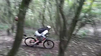
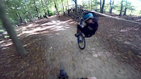
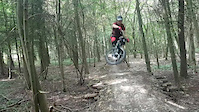
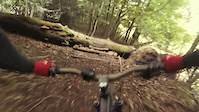
Photos of Brighton Mountain Bike
Videos of Brighton Mountain Bike
trail: RH line
0:10 |
1961 |
Oct 9, 2017
trail: Rooty
2:13 |
193 |
Feb 12, 2017

trail: Huck the pain away
0:22 |
1365 |
Oct 24, 2016
trail: Witch's Table
0:37 |
1036 |
Sep 23, 2016
trail: Buzz Lightyear
5:21 |
1215 |
Sep 23, 2016
trail: Witch's Table
0:49 |
637 |
Sep 3, 2016
trail: Rooty
0:27 |
422 |
Jan 1, 2016

trail: Off Camber
3:38 |
671 |
May 28, 2015
Recent Trail Reports
| status | trail | date | condition | info | user |
|---|---|---|---|---|---|
| Access Trail | May 26, 2026 @ 6:53pm (Europe/London) May 26, 2026 | Dry | Cma75 | ||
| Rocky Road | Apr 25, 2026 @ 9:28am (Europe/London) Apr 25, 2026 | Ideal | ThexMiniman | ||
| Access Road | Apr 25, 2026 @ 9:28am (Europe/London) Apr 25, 2026 | Ideal | ThexMiniman | ||
| Community Coppicing | Apr 25, 2026 @ 9:28am (Europe/London) Apr 25, 2026 | Very Dry | ThexMiniman | ||
| Charlie's Angels | Apr 25, 2026 @ 9:28am (Europe/London) Apr 25, 2026 | Ideal | ThexMiniman | ||
| Off Camber | Apr 25, 2026 @ 9:28am (Europe/London) Apr 25, 2026 | Very Dry | ThexMiniman | ||
| Teepee Trail | Apr 25, 2026 @ 9:28am (Europe/London) Apr 25, 2026 | Very Dry | ThexMiniman | ||
| Access Road | Apr 25, 2026 @ 9:28am (Europe/London) Apr 25, 2026 | Ideal | ThexMiniman | ||
| Zorro's | Apr 25, 2026 @ 9:28am (Europe/London) Apr 25, 2026 | Very Dry | ThexMiniman | ||
| Clara's to Zorro's | Apr 25, 2026 @ 9:28am (Europe/London) Apr 25, 2026 | Very Dry | ThexMiniman |
Activity Feed
| username | action | type | title | date |
|---|---|---|---|---|
| JonathanSherlockopIWKQKl | ridden | trail | activity #97508845 | Jun 21, 2026 @ 12:10pm Jun 21, 2026 |
| Matt7XaFnY | wishlist | trail | activity #97298869 | Jun 18, 2026 @ 11:11pm Jun 18, 2026 |
| lkHJZC | wishlist | trail | activity #97190009 | Jun 17, 2026 @ 9:32am Jun 17, 2026 |
| RebeccayigArm | wishlist | region | activity #97028545 | Jun 15, 2026 @ 1:56am Jun 15, 2026 |
| Andrew7PxNbk | ridden | trail | activity #95864538 | May 30, 2026 @ 10:03am May 30, 2026 |
Recent Comments
| username | type | title | comment | date |
|---|---|---|---|---|
| trail | Just back from a walk round Stanmer to find... | Jan 31, 2026 @ 9:27am Jan 31, 2026 | ||
| trail | Also known as Malcolm Brenner on Strava. | Jan 31, 2026 @ 9:24am Jan 31, 2026 | ||
| trail | Just back from a walk round Stanmer, going... | Jan 31, 2026 @ 9:16am Jan 31, 2026 | ||
| trail | Tight between the trees with a small blind drop. | Jan 1, 2026 @ 2:03pm Jan 1, 2026 | ||
| trail | Overgrown | Jul 8, 2025 @ 10:44am Jul 8, 2025 |
Local Badges
-

10 Blue Trails231 awarded -

Epic Ride Climb 2k47 awarded -

Climbing 10k Badge125 awarded -

Climbing 100k Badge15 awarded -

Epic Ride Descent 2k48 awarded -

Descent 10k Badge127 awarded
Bike & Skill Parks
| name | type | city | rating |
|---|---|---|---|
| Brighton & Hove Pump Track | skill park | Brighton |
Activity Type Stats
| activitytype | trails | distance | descent | descent distance | total vertical | rating | global rank | state rank | photos | reports | routes | ridelogs |
|---|---|---|---|---|---|---|---|---|---|---|---|---|
| Mountain Bike | 77 | 25 miles | 4,865 ft | 14 miles | 466 ft | #1,190 | #44 | 122 | 496 | 1 | 31,815 | |
| E-Bike | 77 | 25 miles | 4,865 ft | 14 miles | 466 ft | #2,143 | #76 | 476 | 1 | 4,087 | ||
| Horse | 18 | 7 miles | 646 ft | 3 miles | 371 ft | #1,150 | #55 | 225 | ||||
| Hike | 56 | 20 miles | 2,986 ft | 10 miles | 466 ft | #5,112 | #115 | 421 | 1 | 1,641 | ||
| Trail Running | 62 | 22 miles | 3,327 ft | 11 miles | 466 ft | #4,265 | #99 | 439 | 1 | 768 |
Frequently Asked Questions About Brighton
▼
What are the best places to ride in Brighton?
Brighton has 2 areas to explore for mountain biking. The top rated areas are:
▼
What are the highest rated mountain biking trails in Brighton?
The highest rated mountain biking trails in Brighton are:
- Stanmer A&E (4.4/5)
- Rail The Roots (4.4/5)
- Zorro's (4.3/5)
- Off Camber (4.3/5)
- Pear Drops (4.2/5)
▼
What is the best time of the year to ride in Brighton?
Based on ride log data, the most popular months to ride in Brighton are:
- June (93 activities)
- May (93 activities)
- September (85 activities)
▼
Where can I park to ride in Brighton?
There are 5 parking locations listed in Brighton. The most popular parking spots are: View all parking and trailhead locations on the map to plan your visit.
Activities
Trails
- By pukkasilvia & contributors
- Admins: wisey, MathieuC, cemoorelife
- #6734 - 10,292 views
- brighton activity log | embed map of Brighton mountain bike trails | brighton mountain biking points of interest
Downloading of trail gps tracks in kml & gpx formats is enabled for Brighton.
You must login to download files.