close
-
Layers w
- Weather Layers
- Pro
- Pro
- Pro
- Pro
- Pro
- Pro
- More Layers
- Pro
- Pro
- Pro
- Pro
-
Upgrade to

3D
Trail Conditions
- Unknown
- Snow Groomed
- Snow Packed
- Snow Covered
- Snow Cover Partial
- Freeze/thaw Cycle
- Icy
- Prevalent Mud
- Wet
- Variable
- Ideal
- Dry
- Very Dry
Trail Flow (Ridden Direction)
Trailforks scans users ridelogs to determine the most popular direction each trail is ridden. A good flowing trail network will have most trails flowing in a single direction according to their intension.
The colour categories are based on what percentage of riders are riding a trail in its intended direction.
The colour categories are based on what percentage of riders are riding a trail in its intended direction.
- > 96%
- > 90%
- > 80%
- > 70%
- > 50%
- < 50%
- bi-directional trail
- no data
Trail Last Ridden
Trailforks scans ridelogs to determine the last time a trail was ridden.
- < 2 days
- < 1 week
- < 2 weeks
- < 1 month
- < 6 months
- > 6 months
Trail Ridden Direction
The intended direction a trail should be ridden.
- Downhill Only
- Downhill Primary
- Both Directions
- Uphill Primary
- Uphill Only
- One Direction
Contribute Details
Colors indicate trail is missing specified detail.
- Description
- Photos
- Description & Photos
- Videos
Trail Popularity ?
Trailforks scans ridelogs to determine which trails are ridden the most in the last 9 months.
Trails are compared with nearby trails in the same city region with a possible 25 colour shades.
Think of this as a heatmap, more rides = more kinetic energy = warmer colors.
- most popular
- popular
- less popular
- not popular
ATV/ORV/OHV Filter
Max Vehicle Width
inches
US Cell Coverage
Legend

Radar Time
Activity Recordings
Trailforks uses anonymized public activity data.
?
Activity Recordings
Trailforks uses anonymized public activity data.
?
Personal Heatmap
▶
Activity Types
all
/
none
▶
Options
2
Date range
month
–
Winter Trails
Warning
A routing network for winter maps does not exist. Selecting trails using the winter trails layer has been disabled.
Missing Trails
Most Popular
Least Popular
Trails are colored based on popularity. The more popular a trail is, the more red. Less popular trails trend towards green.
Jump Magnitude Heatmap
Heatmap of where riders jump on trails. Zoom in to see individual jumps, click circles to view jump details.
BC Backroad Status
![map legend]()
Service Road Atlas is a free to use, community-driven service for viewing and creating reports on the numerous back-country service roads around B.C. and Alberta.

Slope Aspect
Direction the slope faces
Trails Deemphasized
Trails are shown in grey.
Only show trails with no bike usage.
Suggested Layers
Based on selected activity type
Save the current map location and zoom level as your default home location whenever this page is loaded.
Save
No description for Bristol has been added yet!
Login or register to submit one.
This region uses the Uk/Euro style trail grading system.
Activities Click to view
- Mountain Bike
60 trails
- E-Bike
15 trails
- Gravel Bike
0 trails
- Adaptive Bike
0 trails
- Winter Fat Bike
0 trails
- Hike
48 trails
- Trail Running
49 trails
Region Details
- 13
- 2
- 23
- 18
- 4
Region Status
Caution as of May 25, 2026Stats
- Avg Trail Rating
- Trails (view details)
- 62
- Trails Mountain Bike
- 60
- Trails E-Bike
- 15
- Trails Horse
- 3
- Trails Hike
- 48
- Trails Trail Running
- 49
- Total Distance
- 42 miles
- Total Descent
- 7,266 ft
- Total Vertical
- 492 ft
- Highest Trailhead
- 534 ft
- Reports
- 339
- Photos
- 207
- Ridden Counter
- 12,629
Articles

Reframing MTB Announces 2025 Bristol Conference Dates
Jan 21, 2025 from pinkbike.com
The conference aims to make UK mountain biking a better, more inclusive, sustainable, and fun experience for all.
Sub Regions
-
Ashton Court
- 1
- 2
-
Belmont Hill
- 1
- 7
-
Leigh Woods
- 1
- 6
- 2
- 3
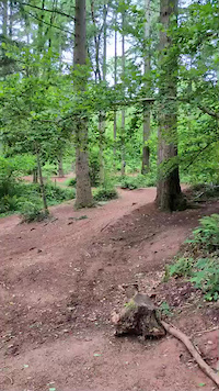
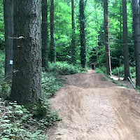
Popular Bristol Mountain Biking Trails
• 100 ★ 3.2 • 2 miles • 180 ft • 602 •
Purpose built XC loop. Connected to a short skills area and optional red sections. Ridden anticlockwise from North Road.
• 100 ★ 3.0 • 404 ft • 0 ft • 563 •
Red switchback descent down to North road
• 95 ★ 4.4 • 2,802 ft • 13 ft • 544 •
Steeper and more technical than the Blue trail. Contains berms, rollers, step ups, drop offs and rock gardens.
• 95 ★ 4.0 • 4 miles • 300 ft • 531 •
BLUE GRADE (Moderate) 6.5KM (4 MILES) 0.75 - 1 HRS Ashton Court is a very busy multi-user site, and the cycle trail crosses and shares walking and horse riding routes. Expect the unexpected and respect pedestrians and horse riders. Warn...
• 75 ★ 3.0 • 1,316 ft • 7 ft • 458 •
Short loop containing a series of obstacles to practice riding; rock gardens, doubles and rollers, off-camber corners, drop-offs and a very short technical climb. Obstacles come in sets of 3, increasing in difficulty, but all can be...
• 80 ★ 0.0 • 1,749 ft • 0 ft • 385 •
Popular blue difficulty singletrack. This mountain bike primary trail can be used downhill primary. On average it takes 6 minutes to complete this trail.
• 85 ★ 0.0 • 351 ft • 0 ft • 382 •
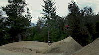
fantastic jump line built by the fine pedal progression, series of tabletops increasing in size to hone your jumping skills!
• 65 ★ 4.7 • 2 miles • 211 ft • 290 •
Moderately popular blue difficulty singletrack. This mountain bike primary trail can be used downhill primary. On average it takes 16 minutes to complete this trail.
Bristol Mountain Bike Routes
★ 4.0 • 17 miles • 1,467 ft • 35 • Loop •
A loop taking in the best of Bristol singletrack taking in the first half of Leigh Woods, down to , can...
17 miles • 1,467 ft • 13 • Loop •
A loop taking in the best of Bristol singletrack taking in the first half of Leigh Woods, down to , can...
12 miles • 1,076 ft • 13 •
Alternative version of 15 miler avoiding the very greasy picnic bench sections.
11 miles • 1,194 ft • 14 • Loop •
a 15 mile ish circular bristol route, leigh olds off piste very muddy and slippy in the wet!!
68 miles • 3,789 ft • 1 • Loop •
a mix of road gravel hills lanes and cycle track. its also possible to camp on mendips
28 miles • 2,191 ft • 0 • Loop •
A few little lanes around bath good for gravel bikes of mtbikes


Recent Trail Reports
| status | trail | date | condition | info | user |
|---|---|---|---|---|---|
| Yer Tiz | Mar 24, 2026 @ 8:52pm (Europe/London) Mar 24, 2026 | Ideal | Edl8 | ||
| Nova | Jul 20, 2025 @ 4:39pm Jul 20, 2025 | Ideal | aizzard | ||
| Super Nova | Dec 24, 2024 @ 2:35am Dec 24, 2024 | Dry | russell-mtb | ||
| Pedal Progression Jump Line | Nov 5, 2023 @ 3:46am Nov 5, 2023 | Variable | Eddavis2890 | ||
| Keener Skills loop | Nov 5, 2023 @ 3:46am Nov 5, 2023 | Wet | Eddavis2890 | ||
| Fish Bounce | Jul 11, 2023 @ 3:03pm Jul 11, 2023 | Dry | NigelHyde | ||
| Oak Wood CLimb | Nov 20, 2022 @ 2:59am Nov 20, 2022 | Wet | NicholastaPACX | ||
| Push Up | Apr 28, 2022 @ 11:16am Apr 28, 2022 | Very Dry | ikHUf | ||
| Picnic Bench Left (Chamonix) | Apr 28, 2022 @ 11:16am Apr 28, 2022 | Very Dry | ikHUf | ||
| Off Piste Beggars Bush | Mar 26, 2022 @ 6:55am Mar 26, 2022 | Ideal | ikHUf |
Activity Feed
| username | action | type | title | date |
|---|---|---|---|---|
| Freddieonwhyte | add | video | activity #96544945 | Jun 8, 2026 @ 9:27am Jun 8, 2026 |
| 7QJxgH | difficultyvote | trail | activity #94827434 | May 16, 2026 @ 9:49am May 16, 2026 |
| mejsi | checkin | trail | activity #94240874 | May 7, 2026 @ 2:18pm May 7, 2026 |
| mejsi | ridden | trail | activity #94240865 | May 7, 2026 @ 2:18pm May 7, 2026 |
| mejsi | wishlist | trail | activity #94161190 | May 6, 2026 @ 9:37am May 6, 2026 |
Recent Comments
| username | type | title | comment | date |
|---|---|---|---|---|
| trail | Nova was incredibly disappointing. The rewards... | Jun 19, 2024 @ 9:35am Jun 19, 2024 | ||
| trail | Now inaccessible due to tree felling | Mar 10, 2024 @ 5:53am Mar 10, 2024 | ||
| trail | A nice XC single track, some trail jumps and... | Mar 12, 2023 @ 1:30pm Mar 12, 2023 | ||
| trail | Good blue that you get out of what you out in.... | Aug 27, 2022 @ 6:05am Aug 27, 2022 | ||
| trail | Pretty much worthless. Would be an ok green... | Aug 27, 2022 @ 6:00am Aug 27, 2022 |
Local Badges
-

Epic Ride Climb 2k93 awarded -

Climbing 10k Badge179 awarded -

Climbing 100k Badge21 awarded -

Epic Ride Descent 2k92 awarded -

Descent 10k Badge179 awarded -

Descent 100k Badge22 awarded
Bike & Skill Parks
| name | type | city | rating |
|---|---|---|---|
| Brunel Way Pumptrack | skill park | Bristol | |
| Stockwood Mini 4X Track and Pump Track | skill park | Bristol | |
| Arno's Court Park Pumptrack | skill park | Bristol | |
| Horfield Pumptrack | skill park | Bristol | |
| Longwell Green Pumptrack | skill park | Bristol |
Local Trail Supporters
- Sustrans
- Bristol Trails Group
Activity Type Stats
| activitytype | trails | distance | descent | descent distance | total vertical | rating | global rank | state rank | photos | reports | routes | ridelogs |
|---|---|---|---|---|---|---|---|---|---|---|---|---|
| Mountain Bike | 60 | 41 miles | 7,031 ft | 21 miles | 492 ft | #855 | #35 | 207 | 337 | 6 | 63,870 | |
| E-Bike | 15 | 4 miles | 1,260 ft | 3 miles | 427 ft | #1,169 | #55 | 238 | 1 | 2,921 | ||
| Horse | 3 | 2 miles | 282 ft | 1 mile | 266 ft | 134 | ||||||
| Hike | 48 | 34 miles | 5,712 ft | 18 miles | 492 ft | #1,650 | 284 | 707 | ||||
| Trail Running | 49 | 34 miles | 5,869 ft | 18 miles | 492 ft | #1,191 | #32 | 284 | 1,179 |
Frequently Asked Questions About Bristol
▼
What are the best places to ride in Bristol?
Bristol has 3 areas to explore for mountain biking. The top rated areas are:
▼
What are the highest rated mountain biking trails in Bristol?
The highest rated mountain biking trails in Bristol are:
- 50 Acre Woods (4.2/5)
- Wired (4.2/5)
- Super Nova (4.2/5)
- Climb to mini downhills (4/5)
- Bluebell Woods (4/5)
▼
What is the best time of the year to ride in Bristol?
Based on ride log data, the most popular months to ride in Bristol are:
- July (197 activities)
- September (154 activities)
- March (122 activities)
▼
Where can I park to ride in Bristol?
There are 3 parking locations listed in Bristol. The most popular parking spots are: View all parking and trailhead locations on the map to plan your visit.
Activities
Trails
Points of Interest
- By ryanme & contributors
- Admins: wisey, MathieuC, cemoorelife, BTG
- #4110 - 29,618 views
- bristol activity log | embed map of Bristol mountain bike trails | bristol mountain biking points of interest
Downloading of trail gps tracks in kml & gpx formats is enabled for Bristol.
You must login to download files.