close
-
Layers w
- Weather Layers
- Pro
- Pro
- Pro
- Pro
- Pro
- Pro
- More Layers
- Pro
- Pro
- Pro
- Pro
-
Upgrade to

3D
Trail Conditions
- Unknown
- Snow Groomed
- Snow Packed
- Snow Covered
- Snow Cover Partial
- Freeze/thaw Cycle
- Icy
- Prevalent Mud
- Wet
- Variable
- Ideal
- Dry
- Very Dry
Trail Flow (Ridden Direction)
Trailforks scans users ridelogs to determine the most popular direction each trail is ridden. A good flowing trail network will have most trails flowing in a single direction according to their intension.
The colour categories are based on what percentage of riders are riding a trail in its intended direction.
The colour categories are based on what percentage of riders are riding a trail in its intended direction.
- > 96%
- > 90%
- > 80%
- > 70%
- > 50%
- < 50%
- bi-directional trail
- no data
Trail Last Ridden
Trailforks scans ridelogs to determine the last time a trail was ridden.
- < 2 days
- < 1 week
- < 2 weeks
- < 1 month
- < 6 months
- > 6 months
Trail Ridden Direction
The intended direction a trail should be ridden.
- Downhill Only
- Downhill Primary
- Both Directions
- Uphill Primary
- Uphill Only
- One Direction
Contribute Details
Colors indicate trail is missing specified detail.
- Description
- Photos
- Description & Photos
- Videos
Trail Popularity ?
Trailforks scans ridelogs to determine which trails are ridden the most in the last 9 months.
Trails are compared with nearby trails in the same city region with a possible 25 colour shades.
Think of this as a heatmap, more rides = more kinetic energy = warmer colors.
- most popular
- popular
- less popular
- not popular
ATV/ORV/OHV Filter
Max Vehicle Width
inches
US Cell Coverage
Legend

Radar Time
Activity Recordings
Trailforks uses anonymized public activity data.
?
Activity Recordings
Trailforks uses anonymized public activity data.
?
Personal Heatmap
▶
Activity Types
all
/
none
▶
Options
2
Date range
month
–
Winter Trails
Warning
A routing network for winter maps does not exist. Selecting trails using the winter trails layer has been disabled.
Missing Trails
Most Popular
Least Popular
Trails are colored based on popularity. The more popular a trail is, the more red. Less popular trails trend towards green.
Jump Magnitude Heatmap
Heatmap of where riders jump on trails. Zoom in to see individual jumps, click circles to view jump details.
BC Backroad Status
![map legend]()
Service Road Atlas is a free to use, community-driven service for viewing and creating reports on the numerous back-country service roads around B.C. and Alberta.

Slope Aspect
Direction the slope faces
Trails Deemphasized
Trails are shown in grey.
Only show trails with no bike usage.
Suggested Layers
Based on selected activity type
Save the current map location and zoom level as your default home location whenever this page is loaded.
Save
No description for Bukit Dinding has been added yet!
Login or register to submit one.
Primary Trail Type: All-Mountain & Downhill
Land Status: City Managed
Activities Click to view
- Mountain Bike
6 trails
- E-Bike
1 trails
- Hike
9 trails
- Trail Running
9 trails
Region Details
- 1
- 1
- 3
- 1
Region Status
Caution as of 14 hoursStats
- Avg Trail Rating
- Trails (view details)
- 6
- Trails Mountain Bike
- 6
- Trails E-Bike
- 1
- Trails Hike
- 9
- Trails Trail Running
- 9
- Total Distance
- 5 miles
- Total Descent
- 2,356 ft
- Total Vertical
- 735 ft
- Highest Trailhead
- 965 ft
- Reports
- 38
- Photos
- 54
- Ridden Counter
- 515
Popular Bukit Dinding Mountain Biking Trails
• 50 ★ 3.5 • 5,098 ft • 17 ft • 87 •
Moderately popular black diamond difficulty singletrack. This mountain bike primary trail and has a hard overall physical rating with a 17 ft black diamond climb. It features berm, bridge, drop, jump, gap jump and rock face. On average it takes 30 minutes to complete this trail.
• 50 ★ 0.0 • 1,667 ft • 3 ft • 57 •
Old DH line but rebuilt with nicely carved singletrack berms and switchbacks. Previously the trail passed by a small goat farm but the new trailfork bring riders to new trail features.
• 50 ★ 0.0 • 2,664 ft • 35 ft • 45 •
another old trail revived by SCARFOX featuring switchback descends.
• 40 ★ 0.0 • 1,952 ft • 8 ft • 6 •
Moderately popular blue difficulty singletrack. This multi-use trail can be used both directions.
Photos of Bukit Dinding Mountain Bike
Videos of Bukit Dinding Mountain Bike

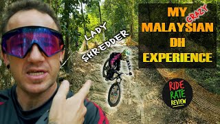
trail: Bukit Dinding - DH Line
0:26 |
193 |
Feb 5, 2022 , Kuala Lumpur

trail: Bukit Dinding - DH Line
5:29 |
204 |
Jan 22, 2022 , Kuala Lumpur

trail: Bukit Dinding - DH Line
4:42 |
281 |
Nov 7, 2021 , Kuala Lumpur
youtuber
![Pure Malaysian DH Trail | Bukit DinDing]()
trail: Bukit Dinding - DH Line
9:46 |
532 |
May 11, 2020 , Kuala Lumpur
youtuber
![Pure Malaysian DH Trail | Bukit DinDing]()

trail: Bukit dinding Climb
9:46 |
591 |
May 29, 2019 , Kuala Lumpur
Recent Trail Reports
| status | trail | date | condition | info | user |
|---|---|---|---|---|---|
| Bukit dinding Climb | Jul 23, 2022 @ 11:46am Jul 23, 2022 | Ideal | ariefb | ||
| Fukuyu | Feb 25, 2022 @ 9:31am Feb 25, 2022 | Variable | faizalfadzil |
Activity Feed
| username | action | type | title | date |
|---|---|---|---|---|
| BaptisteRRRlFG | ridden | trail | activity #94614917 and 2 more | May 13, 2026 @ 2:25am May 13, 2026 |
| mattmalabanan | update | trail | activity #94069618 | May 4, 2026 @ 9:08pm May 4, 2026 |
| martinbridger | wishlist | trail | activity #43085867 and 1 more | Aug 18, 2023 @ 12:31pm Aug 18, 2023 |
| faizalfadzil | add | report | activity #35707256 | Nov 27, 2022 @ 11:24pm Nov 27, 2022 |
| AmnNsr | wishlist | region | activity #34016006 | Sep 28, 2022 @ 12:26am Sep 28, 2022 |
Nearby Areas
| name | distance | ||||
|---|---|---|---|---|---|
| Gombak | 1 | 3.8 km | |||
| Bukit Kiara | 28 | 47 | 12 | 2 | 8.3 km |
| Sungai Long | 4 | 9 | 9.7 km | ||
| Cheras | 9.7 km | ||||
| Kota Damansara Community Forest | 4 | 5 | 11.4 km |
Activity Type Stats
| activitytype | trails | distance | descent | descent distance | total vertical | rating | global rank | state rank | photos | reports | routes | ridelogs |
|---|---|---|---|---|---|---|---|---|---|---|---|---|
| Mountain Bike | 6 | 5 miles | 2,356 ft | 3 miles | 735 ft | #3,019 | #6 | 51 | 38 | 1,548 | ||
| E-Bike | 1 | 2,710 ft | 217 ft | 1,877 ft | 194 ft | #1,739 | #8 | 2 | 15 | 163 | ||
| Hike | 9 | 3 miles | 994 ft | 1 mile | 656 ft | #2,102 | #5 | 1 | 28 | 190 | ||
| Trail Running | 9 | 3 miles | 994 ft | 1 mile | 656 ft | #1,393 | #4 | 28 | 673 |
Frequently Asked Questions About Bukit Dinding
▼
What are the highest rated mountain biking trails in Bukit Dinding?
The highest rated mountain biking trails in Bukit Dinding are:
- Bukit Dinding - DH Line (3.9/5)
- Fakawi (0/5)
- Fukuyu (0/5)
- AM Trail (0/5)
▼
What is the best time of the year to ride in Bukit Dinding?
Based on ride log data, the most popular months to ride in Bukit Dinding are:
- February (14 activities)
- March (7 activities)
- November (6 activities)
▼
Where can I park to ride in Bukit Dinding?
Check the Bukit Dinding trail map for trailhead and parking information. Community members regularly update access and parking details for trails in the area.
▼
What is the longest trail in Bukit Dinding?
The longest trail in Bukit Dinding is Bukit Dinding - DH Line at 1.6 km. View all trails sorted by distance.
- By ZenGecko & contributors
- Admins: TRAKS, TRAKS, TRAKS
- #33028 - 5,033 views
- bukit dinding activity log | embed map of Bukit Dinding mountain bike trails |
Downloading of trail gps tracks in kml & gpx formats is enabled for Bukit Dinding.
You must login to download files.