close
-
Layers w
- Weather Layers
- Pro
- Pro
- Pro
- Pro
- Pro
- Pro
- More Layers
- Pro
- Pro
- Pro
- Pro
-
Upgrade to

3D
Trail Conditions
- Unknown
- Snow Groomed
- Snow Packed
- Snow Covered
- Snow Cover Partial
- Freeze/thaw Cycle
- Icy
- Prevalent Mud
- Wet
- Variable
- Ideal
- Dry
- Very Dry
Trail Flow (Ridden Direction)
Trailforks scans users ridelogs to determine the most popular direction each trail is ridden. A good flowing trail network will have most trails flowing in a single direction according to their intension.
The colour categories are based on what percentage of riders are riding a trail in its intended direction.
The colour categories are based on what percentage of riders are riding a trail in its intended direction.
- > 96%
- > 90%
- > 80%
- > 70%
- > 50%
- < 50%
- bi-directional trail
- no data
Trail Last Ridden
Trailforks scans ridelogs to determine the last time a trail was ridden.
- < 2 days
- < 1 week
- < 2 weeks
- < 1 month
- < 6 months
- > 6 months
Trail Ridden Direction
The intended direction a trail should be ridden.
- Downhill Only
- Downhill Primary
- Both Directions
- Uphill Primary
- Uphill Only
- One Direction
Contribute Details
Colors indicate trail is missing specified detail.
- Description
- Photos
- Description & Photos
- Videos
Trail Popularity ?
Trailforks scans ridelogs to determine which trails are ridden the most in the last 9 months.
Trails are compared with nearby trails in the same city region with a possible 25 colour shades.
Think of this as a heatmap, more rides = more kinetic energy = warmer colors.
- most popular
- popular
- less popular
- not popular
ATV/ORV/OHV Filter
Max Vehicle Width
inches
US Cell Coverage
Legend

Radar Time
Activity Recordings
Trailforks uses anonymized public activity data.
?
Activity Recordings
Trailforks uses anonymized public activity data.
?
Personal Heatmap
▶
Activity Types
all
/
none
▶
Options
2
Date range
month
–
Winter Trails
Warning
A routing network for winter maps does not exist. Selecting trails using the winter trails layer has been disabled.
Missing Trails
Most Popular
Least Popular
Trails are colored based on popularity. The more popular a trail is, the more red. Less popular trails trend towards green.
Jump Magnitude Heatmap
Heatmap of where riders jump on trails. Zoom in to see individual jumps, click circles to view jump details.
BC Backroad Status
![map legend]()
Service Road Atlas is a free to use, community-driven service for viewing and creating reports on the numerous back-country service roads around B.C. and Alberta.

Slope Aspect
Direction the slope faces
Trails Deemphasized
Trails are shown in grey.
Only show trails with no bike usage.
Suggested Layers
Based on selected activity type
Save the current map location and zoom level as your default home location whenever this page is loaded.
Save
No description for Burbank has been added yet!
Login or register to submit one.
Activities Click to view
- Mountain Bike
57 trails
- E-Bike
19 trails
- Adaptive Bike
0 trails
- Winter Fat Bike
0 trails
- Hike
59 trails
- Trail Running
59 trails
Region Details
- 8
- 2
- 8
- 15
- 3
- 2
Region Status
Caution as of Jun 9, 2026Stats
- Avg Trail Rating
- Trails (view details)
- 39
- Trails Mountain Bike
- 58
- Trails E-Bike
- 19
- Trails Hike
- 59
- Trails Trail Running
- 59
- Total Distance
- 50 miles
- Total Descent
- 23,958 ft
- Total Vertical
- 2,230 ft
- Highest Trailhead
- 3,095 ft
- Reports
- 336
- Photos
- 243
- Ridden Counter
- 3,086
Sub Regions
-
Verdugo Mountains
- 2
- 8
- 15
- 3
- 2
Popular Burbank Mountain Biking Trails
• 70 ★ 2.5 • 702 ft • 55 ft • 172 •
Popular blue difficulty singletrack. This mountain bike primary trail can be used both directions. On average it takes 1 minutes to complete this trail.
• 65 ★ 2.0 • 581 ft • 17 ft • 152 •
Moderately popular blue difficulty singletrack. This mountain bike primary trail can be used both directions. On average it takes minutes to complete this trail.
• 70 ★ 4.0 • 3 miles • 68 ft • 150 •
Highly rated popular blue difficulty singletrack. This mountain bike primary trail. On average it takes 24 minutes to complete this trail.
• 95 ★ 4.1 • 1 mile • 44 ft • 126 •
Highly rated popular black diamond difficulty singletrack. This mountain bike primary trail can be used downhill primary. On average it takes 8 minutes to complete this trail.
• 55 ★ 4.3 • 3,296 ft • 48 ft • 118 •
Arguably the most popular single track descent in the Verdugo Mountain range. Take your time up the long strenuous fire road climb and take in the amazing views of the San Fernando Valley. On the way down, enjoy some jumps and flow down...
• 85 ★ 0.0 • 1,335 ft • 9 ft • 51 •
Pretty steep drop in then it’s nice and flat. Then it gets steep but nothing too bad. Overall pretty fun trail but very short.
• 80 ★ 3.5 • 3,074 ft • 39 ft • 49 •
Popular black diamond difficulty singletrack. This mountain bike primary trail with a 39 ft black diamond climb. Trail visibility is always easy to follow. On average it takes 6 minutes to complete this trail.
• 45 ★ 2.0 • 863 ft • 90 ft • 49 •
Moderately popular green difficulty singletrack. This multi-use trail can be used both directions and has a easy overall physical rating with a 90 ft green climb. On average it takes 3 minutes to complete this trail.
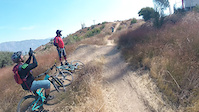
Photos of Burbank Mountain Bike
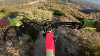
Videos of Burbank Mountain Bike

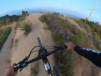
trail: Stough Canyon
2:11 |
|
Jul 17, 2022
trail: Stough Canyon
0:17 |
212 |
Oct 2, 2020
trail: Verdugo Ridge Single Track
8:40 |
756 |
Mar 11, 2020
trail: Chandler Fire Road
5:23 |
234 |
Feb 19, 2020
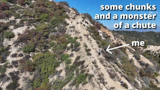
trail: Ghost Pepper
3:07 |
54 |
Jun 2, 2026 , Burbank
trail: Whiting Woods
108 |
Jun 17, 2025 , Burbank
trail: Ghost Pepper
36:34 |
275 |
Mar 7, 2025 , Burbank

trail: Spencers
36:34 |
81 |
Mar 7, 2025 , Burbank
Recent Trail Reports
| status | trail | date | condition | info | user |
|---|---|---|---|---|---|
| Scotts Trail | Jun 9, 2026 @ 11:35am (America/Los_Angeles) Jun 9, 2026 | Dry | Ademargo | ||
| Skyline Way | May 30, 2026 @ 11:41am (America/Los_Angeles) May 30, 2026 | Dry | snowling | ||
| Screw Loose | May 28, 2026 @ 7:59am (America/Los_Angeles) May 28, 2026 | Very Dry | Ademargo | ||
| Hostetter Firebreak | May 25, 2026 @ 9:22pm (America/Los_Angeles) May 25, 2026 | Ideal | Ademargo | ||
| Viper | May 17, 2026 @ 5:34pm (America/Los_Angeles) May 17, 2026 | Ideal | Ademargo | ||
| Valhalla | May 16, 2026 @ 12:32pm (America/Los_Angeles) May 16, 2026 | Ideal | Ademargo | ||
| La Tuna Canyon | May 10, 2026 @ 9:51am (America/Los_Angeles) May 10, 2026 | Unknown | Ademargo | ||
| Chandler Fire Road | May 3, 2026 @ 7:40am (America/Los_Angeles) May 3, 2026 | Variable | tedderb | ||
| Whiting Woods | May 2, 2026 @ 9:00am (America/Los_Angeles) May 2, 2026 | Variable | DudeMotoGP | ||
| Scotts Bonus Drop In | May 2, 2026 @ 9:00am (America/Los_Angeles) May 2, 2026 | Variable | DudeMotoGP |
Activity Feed
| username | action | type | title | date |
|---|---|---|---|---|
| pvuk | wishlist | trail | activity #97222734 and 7 more | Jun 17, 2026 @ 6:11pm Jun 17, 2026 |
| ducksahz | wishlist | region | activity #96789748 | Jun 12, 2026 @ 1:24am Jun 12, 2026 |
| ThomasQRIe4G | add | photo | activity #96705218 | Jun 10, 2026 @ 5:11pm Jun 10, 2026 |
| Ademargo | add | report | activity #96619817 | Jun 9, 2026 @ 11:35am Jun 9, 2026 |
| Ademargo | difficultyvote | trail | activity #96619727 | Jun 9, 2026 @ 11:33am Jun 9, 2026 |
Recent Comments
| username | type | title | comment | date |
|---|---|---|---|---|
| trail | Super fun, but lots of braking bumps right... | May 24, 2026 @ 4:15pm May 24, 2026 | ||
| report | I'd like to see this trail be ridden... | Apr 21, 2026 @ 3:48pm Apr 21, 2026 | ||
| trail | Horrible, never riding again | Apr 13, 2026 @ 8:04pm Apr 13, 2026 | ||
| trail | No way this isn’t a double black, compare it... | Mar 25, 2026 @ 8:30am Mar 25, 2026 | ||
| trail | Nice uphill fireroad grind with some oaks and... | Feb 2, 2026 @ 7:29am Feb 2, 2026 |
Local Badges
-

Completionist0 awarded -

10 Black Trails13 awarded -

Epic Mountain Bike Climb 2k45 awarded -

Climbing 10k Badge34 awarded -

Mountain Biking 100k Badge0 awarded -

Epic Ride Descent 2k45 awarded
Activity Type Stats
| activitytype | trails | distance | descent | descent distance | total vertical | rating | global rank | state rank | photos | reports | routes | ridelogs |
|---|---|---|---|---|---|---|---|---|---|---|---|---|
| Mountain Bike | 57 | 49 miles | 22,943 ft | 30 miles | 2,231 ft | #3,413 | #1,165 | 245 | 335 | 7,471 | ||
| E-Bike | 19 | 12 miles | 8,071 ft | 10 miles | 2,231 ft | #5,013 | #1,568 | 200 | 1,629 | |||
| Hike | 59 | 50 miles | 23,957 ft | 31 miles | 2,231 ft | #4,325 | #1,520 | 4 | 339 | 599 | ||
| Trail Running | 59 | 50 miles | 23,957 ft | 31 miles | 2,231 ft | #3,882 | #1,161 | 339 | 304 |
Frequently Asked Questions About Burbank
▼
What are the best places to ride in Burbank?
Burbank has 1 areas to explore for mountain biking. The top rated areas are:
▼
What are the highest rated mountain biking trails in Burbank?
The highest rated mountain biking trails in Burbank are:
- Viper (4.1/5)
- Breaking bad (4.1/5)
- Vital Link (4.1/5)
- Verdugo Ridge Single Track (4.1/5)
- Skyline Way (4/5)
▼
What is the best time of the year to ride in Burbank?
Based on ride log data, the most popular months to ride in Burbank are:
- July (42 activities)
- October (27 activities)
- May (26 activities)
▼
Where can I park to ride in Burbank?
There are 3 parking locations listed in Burbank. The most popular parking spots are: View all parking and trailhead locations on the map to plan your visit.
Activities
Trails
- By brenthillier
 NSMBA TRAILFORKS & contributors
 - Admins: CORBA
- #6884 - 8,020 views
- burbank activity log | embed map of Burbank mountain bike trails | burbank mountain biking points of interest polygons
Downloading of trail gps tracks in kml & gpx formats is enabled for Burbank.
You must login to download files.