close
-
Layers w
- Weather Layers
- Pro
- Pro
- Pro
- Pro
- Pro
- Pro
- More Layers
- Pro
- Pro
- Pro
- Pro
-
Upgrade to

3D
Trail Conditions
- Unknown
- Snow Groomed
- Snow Packed
- Snow Covered
- Snow Cover Partial
- Freeze/thaw Cycle
- Icy
- Prevalent Mud
- Wet
- Variable
- Ideal
- Dry
- Very Dry
Trail Flow (Ridden Direction)
Trailforks scans users ridelogs to determine the most popular direction each trail is ridden. A good flowing trail network will have most trails flowing in a single direction according to their intension.
The colour categories are based on what percentage of riders are riding a trail in its intended direction.
The colour categories are based on what percentage of riders are riding a trail in its intended direction.
- > 96%
- > 90%
- > 80%
- > 70%
- > 50%
- < 50%
- bi-directional trail
- no data
Trail Last Ridden
Trailforks scans ridelogs to determine the last time a trail was ridden.
- < 2 days
- < 1 week
- < 2 weeks
- < 1 month
- < 6 months
- > 6 months
Trail Ridden Direction
The intended direction a trail should be ridden.
- Downhill Only
- Downhill Primary
- Both Directions
- Uphill Primary
- Uphill Only
- One Direction
Contribute Details
Colors indicate trail is missing specified detail.
- Description
- Photos
- Description & Photos
- Videos
Trail Popularity ?
Trailforks scans ridelogs to determine which trails are ridden the most in the last 9 months.
Trails are compared with nearby trails in the same city region with a possible 25 colour shades.
Think of this as a heatmap, more rides = more kinetic energy = warmer colors.
- most popular
- popular
- less popular
- not popular
ATV/ORV/OHV Filter
Max Vehicle Width
inches
US Cell Coverage
Legend

Radar Time
Activity Recordings
Trailforks uses anonymized public activity data.
?
Activity Recordings
Trailforks uses anonymized public activity data.
?
Personal Heatmap
▶
Activity Types
all
/
none
▶
Options
2
Date range
month
–
Winter Trails
Warning
A routing network for winter maps does not exist. Selecting trails using the winter trails layer has been disabled.
Missing Trails
Most Popular
Least Popular
Trails are colored based on popularity. The more popular a trail is, the more red. Less popular trails trend towards green.
Jump Magnitude Heatmap
Heatmap of where riders jump on trails. Zoom in to see individual jumps, click circles to view jump details.
BC Backroad Status
![map legend]()
Service Road Atlas is a free to use, community-driven service for viewing and creating reports on the numerous back-country service roads around B.C. and Alberta.

Slope Aspect
Direction the slope faces
Trails Deemphasized
Trails are shown in grey.
Only show trails with no bike usage.
Suggested Layers
Based on selected activity type
Save the current map location and zoom level as your default home location whenever this page is loaded.
Save
No description for Burnet has been added yet!
Login or register to submit one.
Activities Click to view
- Mountain Bike
58 trails
- E-Bike
22 trails
- Gravel Bike
0 trails
- Adaptive Bike
0 trails
- Hike
26 trails
- Trail Running
29 trails
Region Details
- 6
- 10
- 16
- 13
- 5
Region Status
Open as of Jun 16, 2026Stats
- Avg Trail Rating
- Trails (view details)
- 50
- Trails Mountain Bike
- 61
- Trails E-Bike
- 22
- Trails Hike
- 26
- Trails Trail Running
- 29
- Total Distance
- 42 miles
- Total Descent
- 6,450 ft
- Total Vertical
- 534 ft
- Highest Trailhead
- 1,426 ft
- Reports
- 513
- Photos
- 124
- Ridden Counter
- 32,349
Articles

BetterRide Enduro MTB Skills Course with Cody Kelley Announced For November 10-12
Oct 9, 2023 from pinkbike.com
The event will be held at Spider Mountain Bike Park in Austin.

Video: First Impressions of the Year Round Lift Access at Spider Mountain in Texas
Feb 7, 2019 from pinkbike.com
Our new First Impressions series showcases different trail centers and bike parks to give you the lowdown on what each destination has to offer.
Sub Regions
-
Inks Lake State Park
- 1
- 9
- 5
-
Reveille Peak Ranch
- 6
- 8
- 7
- 3
-
Spider Mountain Bike Park
- 3
- 6
- 3
- 2
Popular Burnet Mountain Biking Trails
• 100 ★ 3.9 • 1,621 ft • 0 ft • 1,656 •
Popular black diamond difficulty singletrack. This mountain bike primary trail can be used downhill only and has a hard overall physical rating. It features roller coaster. Trail visibility is always easy to follow. On average it takes 2 minutes to complete this trail.
• 55 ★ 4.5 • 3,970 ft • 0 ft • 1,634 •
This trail was built in a record 9 days top to bottom! It is an awesome flowy trail bike trail that is sure to not dissapoint! It is most people's favorite fun and techy trail at Spider Mountain. Use this to link up to other trails to...
• 85 ★ 4.3 • 1 mile • 0 ft • 1,626 •
is our premier easy green trail. It is a great first time experience that is family friendly and offers some progression to work your way up to the blue trails. With lake views and an awesome mountain feel, this trail is an awesome...
• 80 ★ 4.8 • 2,175 ft • 0 ft • 1,609 •
Highly rated popular blue difficulty singletrack. This mountain bike primary trail can be used downhill only. On average it takes 1 minutes to complete this trail.
• 50 ★ 4.8 • 1,220 ft • 0 ft • 1,341 •
Newly built and maintained flow trail at Spider Mountain with big rollers and a whole lot of flow. Good trail to get warmed up and hone your pumping skills.
• 95 ★ 3.8 • 4,501 ft • 67 ft • 1,309 •
Popular green difficulty singletrack. This mountain bike primary trail. On average it takes 5 minutes to complete this trail.
Burnet Mountain Bike Routes
★ 2.0 • 3 miles • 256 ft • 2 • Loop •
Just the loop from the parking lot and return to a junction with Beginner Loop (frmly League Loop) to do...
11 miles • 1,186 ft • 4 •
If you only have one day to spend at Reveille Peak Ranch and you want to do it all, this is a great route...
★ 5.0 • 12 miles • 1,054 ft • 34 •
This is a fun techy loop with granite slabs, techy climbs, and descents.
13 miles • 1,149 ft • 9 •
Beginner Loop to Flow Trail to Race Loop to Cross & Rock Trails
10 miles • 908 ft • 9 •
The enduro race here is brutal, especially if you don't know your way around. This route gives you the...
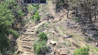
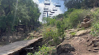
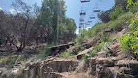
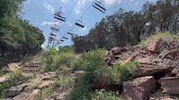
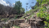
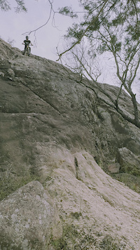
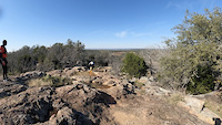
Photos of Burnet Mountain Bike
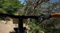
Videos of Burnet Mountain Bike
trail: Sleep Tight
0:22 |
74 |
Apr 23, 2025
trail: Sleep Tight
0:12 |
68 |
Apr 21, 2025
trail: Sleep Tight
0:14 |
50 |
Apr 21, 2025
trail: Sleep Tight
0:16 |
39 |
Apr 21, 2025
trail: Sleep Tight
0:10 |
90 |
Apr 19, 2025
0:10 |
35 |
Mar 5, 2024
trail: Stinger
0:09 |
196 |
Apr 21, 2023
trail: Super D
0:04 |
200 |
Dec 21, 2022
Recent Trail Reports
| status | trail | date | condition | info | user |
|---|---|---|---|---|---|
| RPR Trail | Mar 13, 2026 @ 4:06pm (America/Chicago) Mar 13, 2026 | Unknown | BrianZnsPFh | ||
| Sidewinder Connector | Mar 6, 2026 @ 7:16am (Pacific/Midway) Mar 6, 2026 | Variable | steuer | ||
| Sticky Icky | Mar 6, 2026 @ 7:16am (Pacific/Midway) Mar 6, 2026 | Ideal | steuer | ||
| Viper's Den | Mar 6, 2026 @ 7:16am (Pacific/Midway) Mar 6, 2026 | Ideal | steuer | ||
| Cedar Fever | Mar 6, 2026 @ 7:16am (Pacific/Midway) Mar 6, 2026 | Ideal | steuer | ||
| Creepy Crawly Skills Park | Mar 6, 2026 @ 7:16am (Pacific/Midway) Mar 6, 2026 | Variable | steuer | ||
| Itsy Bitsy | Mar 6, 2026 @ 7:16am (Pacific/Midway) Mar 6, 2026 | Variable | steuer | ||
| Centipede | Mar 6, 2026 @ 7:16am (Pacific/Midway) Mar 6, 2026 | Wet | steuer | ||
| Access Road | Mar 1, 2026 @ 6:55am (Pacific/Midway) Mar 1, 2026 | Dry | steuer | ||
| Sidewinder | Mar 1, 2026 @ 6:55am (Pacific/Midway) Mar 1, 2026 | Unknown | steuer |
Activity Feed
| username | action | type | title | date |
|---|---|---|---|---|
| s30james | wishlist | route | activity #97053457 | Jun 15, 2026 @ 11:02am Jun 15, 2026 |
| travistag | wishlist | region | activity #96880796 | Jun 13, 2026 @ 8:30am Jun 13, 2026 |
| NonyPz | wishlist | region | activity #96879982 | Jun 13, 2026 @ 8:22am Jun 13, 2026 |
| coachkevin-rideready | wishlist | region | activity #96759935 | Jun 11, 2026 @ 1:57pm Jun 11, 2026 |
| ThompsonJ | wishlist | region | activity #96447515 | Jun 7, 2026 @ 4:49am Jun 7, 2026 |
Recent Comments
| username | type | title | comment | date |
|---|---|---|---|---|
| report | Walnut Creek was fun and fast. Nice jumps... | Oct 10, 2025 @ 7:51pm Oct 10, 2025 | ||
| report | Wow disappointing. Headed to Burnett next... | Oct 10, 2025 @ 7:16pm Oct 10, 2025 | ||
| trail | Very overgrown bushwhacking on all parts of... | Oct 10, 2025 @ 6:57pm Oct 10, 2025 | ||
| trail | Super slow lift. | Apr 7, 2024 @ 4:05pm Apr 7, 2024 | ||
| trail | Def a blue trail rather than a green - so fun!... | Jan 27, 2024 @ 10:03am Jan 27, 2024 |
Local Badges
-

Epic Ride Climb 2k162 awarded -

Climbing 10k Badge125 awarded -

Climbing 100k Badge1 awarded -

Epic Ride Descent 2k180 awarded -

Descent 10k Badge132 awarded -

Descent 100k Badge1 awarded
Bike & Skill Parks
| name | type | city | rating |
|---|---|---|---|
| Spider Mountain Bike Park | bike park | Burnet | |
| Creepy Crawly Skills Park | skill park | Burnet |
Activity Type Stats
| activitytype | trails | distance | descent | descent distance | total vertical | rating | global rank | state rank | photos | reports | routes | ridelogs |
|---|---|---|---|---|---|---|---|---|---|---|---|---|
| Mountain Bike | 58 | 42 miles | 6,450 ft | 20 miles | 535 ft | #591 | #219 | 132 | 513 | 16 | 14,510 | |
| E-Bike | 22 | 13 miles | 1,686 ft | 6 miles | 535 ft | #4,496 | #1,448 | 1 | 448 | 6 | 829 | |
| Hike | 26 | 27 miles | 2,631 ft | 11 miles | 384 ft | #6,039 | #2,113 | 464 | 335 | |||
| Trail Running | 29 | 33 miles | 3,248 ft | 14 miles | 384 ft | #5,006 | #1,564 | 467 | 1 | 140 |
Frequently Asked Questions About Burnet
▼
What are the best places to ride in Burnet?
Burnet has 3 areas to explore for mountain biking. The top rated areas are:
▼
What are the highest rated mountain biking trails in Burnet?
The highest rated mountain biking trails in Burnet are:
- Recluse (4.5/5)
- Super D (4.4/5)
- Centipede (4.4/5)
- Viper's Den (4.3/5)
- Beginner Loop (4.3/5)
▼
What is the best time of the year to ride in Burnet?
Based on ride log data, the most popular months to ride in Burnet are:
- December (122 activities)
- March (103 activities)
- April (102 activities)
▼
Where can I park to ride in Burnet?
There are 5 parking locations listed in Burnet. The most popular parking spots are: View all parking and trailhead locations on the map to plan your visit.
Activities
Trails
- By PeytonP & contributors
- Admins: ARR
- #7955 - 4,573 views
- burnet activity log | embed map of Burnet mountain bike trails | burnet mountain biking points of interest
Downloading of trail gps tracks in kml & gpx formats is enabled for Burnet.
You must login to download files.