close
-
Layers w
- Weather Layers
- Pro
- Pro
- Pro
- Pro
- Pro
- Pro
- More Layers
- Pro
- Pro
- Pro
- Pro
-
Upgrade to

3D
Trail Conditions
- Unknown
- Snow Groomed
- Snow Packed
- Snow Covered
- Snow Cover Partial
- Freeze/thaw Cycle
- Icy
- Prevalent Mud
- Wet
- Variable
- Ideal
- Dry
- Very Dry
Trail Flow (Ridden Direction)
Trailforks scans users ridelogs to determine the most popular direction each trail is ridden. A good flowing trail network will have most trails flowing in a single direction according to their intension.
The colour categories are based on what percentage of riders are riding a trail in its intended direction.
The colour categories are based on what percentage of riders are riding a trail in its intended direction.
- > 96%
- > 90%
- > 80%
- > 70%
- > 50%
- < 50%
- bi-directional trail
- no data
Trail Last Ridden
Trailforks scans ridelogs to determine the last time a trail was ridden.
- < 2 days
- < 1 week
- < 2 weeks
- < 1 month
- < 6 months
- > 6 months
Trail Ridden Direction
The intended direction a trail should be ridden.
- Downhill Only
- Downhill Primary
- Both Directions
- Uphill Primary
- Uphill Only
- One Direction
Contribute Details
Colors indicate trail is missing specified detail.
- Description
- Photos
- Description & Photos
- Videos
Trail Popularity ?
Trailforks scans ridelogs to determine which trails are ridden the most in the last 9 months.
Trails are compared with nearby trails in the same city region with a possible 25 colour shades.
Think of this as a heatmap, more rides = more kinetic energy = warmer colors.
- most popular
- popular
- less popular
- not popular
ATV/ORV/OHV Filter
Max Vehicle Width
inches
US Cell Coverage
Legend

Radar Time
Activity Recordings
Trailforks uses anonymized public activity data.
?
Activity Recordings
Trailforks uses anonymized public activity data.
?
Personal Heatmap
▶
Activity Types
all
/
none
▶
Options
2
Date range
month
–
Winter Trails
Warning
A routing network for winter maps does not exist. Selecting trails using the winter trails layer has been disabled.
Missing Trails
Most Popular
Least Popular
Trails are colored based on popularity. The more popular a trail is, the more red. Less popular trails trend towards green.
Jump Magnitude Heatmap
Heatmap of where riders jump on trails. Zoom in to see individual jumps, click circles to view jump details.
BC Backroad Status
![map legend]()
Service Road Atlas is a free to use, community-driven service for viewing and creating reports on the numerous back-country service roads around B.C. and Alberta.

Slope Aspect
Direction the slope faces
Trails Deemphasized
Trails are shown in grey.
Only show trails with no bike usage.
Suggested Layers
Based on selected activity type
Save the current map location and zoom level as your default home location whenever this page is loaded.
SaveCabo Rojo is one of the 78 municipios of Puerto Rico.
Activities Click to view
- Mountain Bike
169 trails
- E-Bike
170 trails
- Gravel Bike
5 trails
- Adaptive Bike
0 trails
- Winter Fat Bike
1 trails
- Horse
4 trails
- Hike
152 trails
- Trail Running
151 trails
- Dirtbike/Moto
11 trails
Region Details
- 10
- 91
- 53
- 13
- 1
Region Status
Open as of Jun 8, 2026Stats
- Avg Trail Rating
- Trails (view details)
- 169
- Trails Mountain Bike
- 169
- Trails E-Bike
- 170
- Trails Gravel Bike
- 5
- Trails Winter Fat Bike
- 1
- Trails Horse
- 4
- Trails Hike
- 152
- Trails Trail Running
- 151
- Trails Dirtbike/Moto
- 11
- Trails Observed Trials
- 1
- Trails ATV/ORV/OHV
- 2
- Trails Downhill Ski
- 1
- Total Distance
- 119 miles
- Total Descent
- 14,238 ft
- Total Vertical
- 957 ft
- Highest Trailhead
- 957 ft
- Reports
- 1,350
- Photos
- 180
- Ridden Counter
- 17,264
Sub Regions
-
Boqueron
-
El Cangrejo Trail Network
- 1
- 1
-
Faro de Cabo Rojo Trail Network
- 4
- 4
-
La 22 Trail Network
- 6
-
Laguna Cartagena Trail Network
- 3
-
Monte Pirata Trail Network
- 1
-
Pitahaya Trail Network
- 7
-
Punta Guaniquilla Trail Network
- 12
- 2
-
Sierra Bermeja
- 3
- 1
-
Viandón Trail Network
- 54
- 41
- 6
- 1
Popular Cabo Rojo Mountain Biking Trails
• 100 ★ 4.0 • 1,139 ft • 0 ft • 314 •
Popular green difficulty dirt/gravel road. This mountain bike primary trail can be used both directions and has a easy overall physical rating with a 0 ft green climb. On average it takes minutes to complete this trail.
• 100 ★ 0.0 • 1,242 ft • 32 ft • 304 •
Popular blue difficulty singletrack. This mountain bike primary trail can be used uphill primary. On average it takes 1 minutes to complete this trail.
• 100 ★ 0.0 • 846 ft • 2 ft • 276 •
Popular blue difficulty singletrack. This mountain bike primary trail can be used both directions. On average it takes minutes to complete this trail.
• 75 ★ 4.8 • 4 miles • 391 ft • 273 •
Cross-country trail in a coastal area, expect sand.
• 95 ★ 2.0 • 4,468 ft • 9 ft • 272 •
Popular green difficulty dirt/gravel road. This mountain bike primary trail can be used both directions and has a easy overall physical rating with a 9 ft green climb. On average it takes 4 minutes to complete this trail.
• 100 ★ 3.0 • 3,688 ft • 125 ft • 255 •
Popular blue difficulty singletrack. This mountain bike primary trail can be used downhill primary and has a moderate overall physical rating with a 125 ft blue climb. It features roller coaster and wallride. On average it takes 2 minutes to complete this trail.
• 100 ★ 4.0 • 2 miles • 0 ft • 254 •
Easy singletrack right next to Refugio de Vida Silvestre de Boquerón.
• 95 ★ 5.0 • 4,629 ft • 113 ft • 253 •
Popular blue difficulty singletrack. This multi-use trail can be used both directions and has a easy overall physical rating with a 113 ft blue climb. Adaptive MTB rating: amtb green. On average it takes 8 minutes to complete this trail.
Cabo Rojo Mountain Bike Routes
12 miles • 858 ft • 16 • Point to Point •
Saliendo del Viandón y llegando a la Farmacia de Combate. Los Mosquitos, Lago Seco, alrevés, Quebrada...
★ 2.0 • 23 miles • 1,025 ft • 12 • Loop •
Ruta de La Pitahaya creada por los Domingueros el dia de las Madres en el 2019
6 miles • 409 ft • 7 • Loop •
La ruta pasa por el tunel del tren y la Punta Guaniquilla.Se entra por Villa Taina hasta el porton verde.
• 14 miles • 960 ft • 1 •
• 19 miles • 1,729 ft • 21 •
Photos of Cabo Rojo Mountain Bike
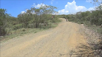
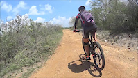
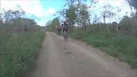
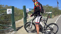
Videos of Cabo Rojo Mountain Bike
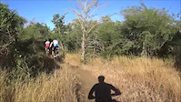
trail: Las Garzas Trail
5:33 |
120 |
Jan 10, 2016
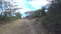
trail: Los Cristales
3:02 |
151 |
Dec 28, 2015
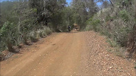
trail: El Perro Trail
3:25 |
104 |
Oct 27, 2015
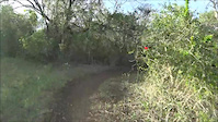
trail: Las Garzas Trail
5:21 |
52 |
Oct 26, 2015
trail: Mirador
2:11 |
48 |
Oct 25, 2015
trail: Triple Perro Trail
4:29 |
251 |
Oct 25, 2015
trail: El Vertedero Trail
2:58 |
45 |
Oct 25, 2015
trail: Combate
6:07 |
168 |
Oct 25, 2015
Recent Trail Reports
| status | trail | date | condition | info | user |
|---|---|---|---|---|---|
| Salinas | Jun 8, 2026 @ 6:06pm (America/Puerto_Rico) Jun 8, 2026 | Dry | JoeyCruz67 | ||
| Conector Road | May 3, 2026 @ 1:45pm (America/Puerto_Rico) May 3, 2026 | Dry | RmAZ6F | ||
| Camino Del Tren Trail | May 3, 2026 @ 1:44pm (America/Puerto_Rico) May 3, 2026 | Unknown | RmAZ6F | ||
| Guaniquilla Trail | Apr 14, 2026 @ 4:08pm (America/Puerto_Rico) Apr 14, 2026 | Unknown | Darys14 | ||
| Las Garzas Trail | Apr 13, 2026 @ 9:48pm (America/Puerto_Rico) Apr 13, 2026 | Unknown | lando1971 | ||
| El Laberinto Trail | Feb 23, 2026 @ 10:01am (America/Puerto_Rico) Feb 23, 2026 | Very Dry | jacevedom | ||
| Los Pozos Trail | Feb 23, 2026 @ 10:01am (America/Puerto_Rico) Feb 23, 2026 | Prevalent Mud | jacevedom | ||
| Monte Carlo Trail | Feb 23, 2026 @ 10:01am (America/Puerto_Rico) Feb 23, 2026 | Dry | jacevedom | ||
| Camino Monte Carlo | Feb 23, 2026 @ 10:01am (America/Puerto_Rico) Feb 23, 2026 | Dry | jacevedom | ||
| Las Guanábanas Trail | Feb 23, 2026 @ 10:01am (America/Puerto_Rico) Feb 23, 2026 | Prevalent Mud | jacevedom |
Activity Feed
| username | action | type | title | date |
|---|---|---|---|---|
| JoeyCruz67 | add | trail | activity #97700926 | Jun 24, 2026 @ 8:48am 3 days |
| JoeyCruz67 | add | trail | activity #97691217 | Jun 24, 2026 @ 6:00am Jun 24, 2026 |
| Mneste1 | wishlist | trail | activity #97658599 and 39 more | Jun 23, 2026 @ 4:21pm Jun 23, 2026 |
| JoeyCruz67 | add | report | activity #96566063 | Jun 8, 2026 @ 3:06pm Jun 8, 2026 |
| JoeyCruz67 | add | trail | activity #95476433 | May 25, 2026 @ 4:04am May 25, 2026 |
Recent Comments
| username | type | title | comment | date |
|---|---|---|---|---|
| trail | This is a gem of a find in PR. Tight single... | Jan 1, 2023 @ 7:34pm Jan 1, 2023 | ||
| report | Obstrucción. Maleza alta. | Dec 18, 2022 @ 5:14pm Dec 18, 2022 | ||
| report | A la altura del cruce con Tamarindo. | Dec 18, 2022 @ 5:09pm Dec 18, 2022 | ||
| report | Seco excepto la parte de la foto. | Jul 28, 2022 @ 3:06pm Jul 28, 2022 | ||
| trail | Ruta esta marcada cerrada 7/25/2021 | Jul 25, 2021 @ 9:27am Jul 25, 2021 |
Local Badges
-

10 Green Trails243 awarded -

10 Blue Trails206 awarded -

Epic Ride Climb 2k22 awarded -

Climbing 10k Badge70 awarded -

Climbing 100k Badge9 awarded -

Epic Ride Descent 2k22 awarded
Activity Type Stats
| activitytype | trails | distance | descent | descent distance | total vertical | rating | global rank | state rank | photos | reports | routes | ridelogs |
|---|---|---|---|---|---|---|---|---|---|---|---|---|
| Mountain Bike | 169 | 117 miles | 14,163 ft | 40 miles | 958 ft | #499 | #1 | 176 | 1,348 | 4 | 18,162 | |
| E-Bike | 170 | 119 miles | 14,239 ft | 41 miles | 958 ft | #436 | #2 | 1,230 | 1,446 | |||
| Gravel Bike | 5 | #215 | #21 | 3 | 11 | |||||||
| Winter Fat Bike | 1 | #168 | #11 | 2 | ||||||||
| Horse | 4 | 2 miles | 36 ft | 1,732 ft | 115 ft | #644 | #2 | 139 | ||||
| Hike | 152 | 111 miles | 13,455 ft | 37 miles | 958 ft | #951 | #2 | 4 | 1,329 | 331 | ||
| Trail Running | 151 | 108 miles | 13,373 ft | 37 miles | 958 ft | #663 | #1 | 1,328 | 902 | |||
| Dirtbike/Moto | 11 | 5 miles | 253 ft | 1 mile | 171 ft | #418 | #1 | 139 | 1 | |||
| Observed Trials | 1 | 2,707 ft | 36 ft | 131 ft | 1 | 27 | ||||||
| ATV/ORV/OHV | 2 | 1 mile | 20 ft | 1,217 ft | 3 ft | 138 | ||||||
| Downhill Ski | 1 | 2,707 ft | 36 ft | 131 ft |
Frequently Asked Questions About Cabo Rojo
▼
What are the best places to ride in Cabo Rojo?
Cabo Rojo has 10 areas to explore for mountain biking. The top rated areas are:
▼
What are the highest rated mountain biking trails in Cabo Rojo?
The highest rated mountain biking trails in Cabo Rojo are:
- Monte Pirata Trail (4.4/5)
- Cactus (4.2/5)
- Las Iguanas Trail (4.2/5)
- Sal Si Puedes (4.2/5)
- Cactus 2 (4.1/5)
▼
What is the best time of the year to ride in Cabo Rojo?
Based on ride log data, the most popular months to ride in Cabo Rojo are:
- January (98 activities)
- February (82 activities)
- May (79 activities)
▼
Where can I park to ride in Cabo Rojo?
There are 2 parking locations listed in Cabo Rojo. The most popular parking spots are:
Activities
Trails
Points of Interest
- By MichaelDescartes
 TRAILFORKS MTBRC Puerto Rico & contributors
 - Admins: apply
- #10440 - 15,619 views
- cabo rojo activity log | embed map of Cabo Rojo mountain bike trails | cabo rojo mountain biking points of interest
Downloading of trail gps tracks in kml & gpx formats is enabled for Cabo Rojo.
You must login to download files.