close
-
Layers w
- Weather Layers
- Pro
- Pro
- Pro
- Pro
- Pro
- Pro
- More Layers
- Pro
- Pro
- Pro
- Pro
-
Upgrade to

3D
Trail Conditions
- Unknown
- Snow Groomed
- Snow Packed
- Snow Covered
- Snow Cover Partial
- Freeze/thaw Cycle
- Icy
- Prevalent Mud
- Wet
- Variable
- Ideal
- Dry
- Very Dry
Trail Flow (Ridden Direction)
Trailforks scans users ridelogs to determine the most popular direction each trail is ridden. A good flowing trail network will have most trails flowing in a single direction according to their intension.
The colour categories are based on what percentage of riders are riding a trail in its intended direction.
The colour categories are based on what percentage of riders are riding a trail in its intended direction.
- > 96%
- > 90%
- > 80%
- > 70%
- > 50%
- < 50%
- bi-directional trail
- no data
Trail Last Ridden
Trailforks scans ridelogs to determine the last time a trail was ridden.
- < 2 days
- < 1 week
- < 2 weeks
- < 1 month
- < 6 months
- > 6 months
Trail Ridden Direction
The intended direction a trail should be ridden.
- Downhill Only
- Downhill Primary
- Both Directions
- Uphill Primary
- Uphill Only
- One Direction
Contribute Details
Colors indicate trail is missing specified detail.
- Description
- Photos
- Description & Photos
- Videos
Trail Popularity ?
Trailforks scans ridelogs to determine which trails are ridden the most in the last 9 months.
Trails are compared with nearby trails in the same city region with a possible 25 colour shades.
Think of this as a heatmap, more rides = more kinetic energy = warmer colors.
- most popular
- popular
- less popular
- not popular
ATV/ORV/OHV Filter
Max Vehicle Width
inches
US Cell Coverage
Legend

Radar Time
Activity Recordings
Trailforks uses anonymized public activity data.
?
Activity Recordings
Trailforks uses anonymized public activity data.
?
Personal Heatmap
▶
Activity Types
all
/
none
▶
Options
2
Date range
month
–
Winter Trails
Warning
A routing network for winter maps does not exist. Selecting trails using the winter trails layer has been disabled.
Missing Trails
Most Popular
Least Popular
Trails are colored based on popularity. The more popular a trail is, the more red. Less popular trails trend towards green.
Jump Magnitude Heatmap
Heatmap of where riders jump on trails. Zoom in to see individual jumps, click circles to view jump details.
BC Backroad Status
![map legend]()
Service Road Atlas is a free to use, community-driven service for viewing and creating reports on the numerous back-country service roads around B.C. and Alberta.

Slope Aspect
Direction the slope faces
Trails Deemphasized
Trails are shown in grey.
Only show trails with no bike usage.
Suggested Layers
Based on selected activity type
Save the current map location and zoom level as your default home location whenever this page is loaded.
SaveCiudad de Calatayud. Genial gestionado por su ayuntamiento
Página web del ayuntamiento sobre ciclismo: https://bike.calatayud.es/
Página web del ayuntamiento sobre ciclismo: https://bike.calatayud.es/
This region uses the Uk/Euro style trail grading system.
Activities Click to view
- Mountain Bike
303 trails
- E-Bike
303 trails
- Gravel Bike
6 trails
- Adaptive Bike
23 trails
- Horse
18 trails
- Hike
297 trails
- Trail Running
297 trails
Region Details
- 117
- 5
- 7
- 162
- 12
Region Status
Open as of Jun 14, 2026Stats
- Avg Trail Rating
- Trails (view details)
- 303
- Trails Mountain Bike
- 303
- Trails E-Bike
- 303
- Trails Gravel Bike
- 6
- Trails Adaptive Bike
- 23
- Trails Winter Fat Bike
- 38
- Trails Horse
- 18
- Trails Hike
- 297
- Trails Trail Running
- 297
- Total Distance
- 391 miles
- Total Descent Distance
- 187 miles
- Total Descent
- 61,361 ft
- Total Vertical
- 3,521 ft
- Highest Trailhead
- 4,607 ft
- Reports
- 226
- Photos
- 130
- Ridden Counter
- 5,322
Sub Regions
-
Ariza
- 1
- 16
-
Calatayud Bike
- 4
- 122
- 12
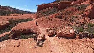
Popular Calatayud Mountain Biking Trails
• 100 ★ 4.0 • 2 miles • 23 ft • 133 •
Popular blue difficulty singletrack. This multi-use trail can be used downhill primary and has a moderate overall physical rating with a 23 ft blue climb. On average it takes 10 minutes to complete this trail.
• 100 ★ 3.8 • 1,755 ft • 0 ft • 128 •
Senda para seguir a continuación del tubo . No tiene ninguna dificultad. Hay que pedalear algo
• 95 ★ 3.7 • 1 mile • 318 ft • 121 •
Azul inferior. Subida al segunda alto para hacer bajadas de y 10º Aniversario. estrecho , con vistas espectaculares, y un buen repecho rocoso
• 100 ★ 4.0 • 1 mile • 243 ft • 118 •
Sendero brutal, muy flow, subida exigente, pero pedaleable con pulmonar, algún tramo expuesto pero que no te dejará indiferente
• 95 ★ 3.0 • 3,770 ft • 130 ft • 115 •
Popular green difficulty singletrack. This multi-use trail can be used both directions and has a moderate overall physical rating with a 130 ft green climb. Trail visibility is always easy to follow. On average it takes 6 minutes to complete this trail.
• 95 ★ 3.7 • 2 miles • 50 ft • 111 •
Popular blue difficulty singletrack. This multi-use trail can be used both directions. Trail visibility is always easy to follow. On average it takes 18 minutes to complete this trail.
Calatayud Mountain Bike Routes
22 miles • 2,372 ft • 8 • Loop •
Ante todo , Muchas Gracias a Miguel, un gran anfitrión y guía que nos "abordo" a nuestra llegada a...
16 miles • 1,647 ft • 3 • Loop •
Recorrido circular de puro rally maratón ideal para los amantes de las rutas por pista, que se adentra en...
12 miles • 665 ft • 4 • Loop •
Versión corta pero muy completa, para recorrer el paraje del Barranco Bartolina, por un sendero fácil...
194 miles • 16,127 ft • 40 • Point to Point •
Tienes ante ti 300 intensos kilómetros de paisajes, historia, arte y aventura, recorriendo viejos y...
19 miles • 2,325 ft • 11 •
Ruta circular por las sendas de la Sierra de Armantes.
13 miles • 345 ft • 3 • Out & Back •
Agradable recorrido, ideal para realizar en familia o iniciarse al mundo de la bicicleta, que comienza en...
Photos of Calatayud Mountain Bike
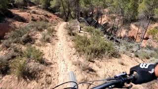
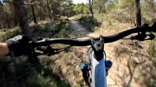
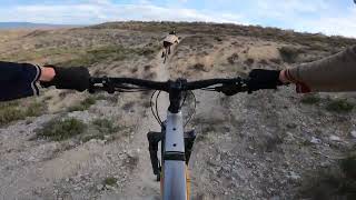
Videos of Calatayud Mountain Bike
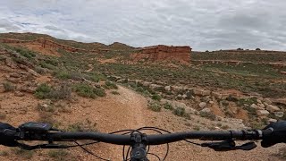
trail: Far West
0:49 |
155 |
Apr 19, 2025 , Calatayud
trail: Maño Mío
4:41 |
133 |
Aug 22, 2023 , Calatayud
trail: Valdechorche
10:49 |
209 |
Aug 7, 2023 , Calatayud
![Skydio 2+ - Calatayud : [4k]](https://ev1.pinkbike.org/tf/vt/1/yvt-153343-4.jpg)
11:34 |
173 |
Dec 2, 2022
3:51 |
136 |
Nov 11, 2022
4:50 |
80 |
Aug 20, 2025
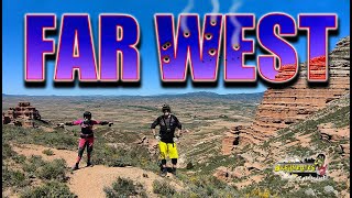
trail: Far West
38:39 |
143 |
May 1, 2024 , Calatayud
Recent Trail Reports
Activity Feed
| username | action | type | title | date |
|---|---|---|---|---|
| banpeta | wishlist | trail | activity #97210136 | Jun 17, 2026 @ 2:38pm 5 hours |
| Grosso | add | photo | activity #96988376 and 2 more | Jun 14, 2026 @ 11:11am Jun 14, 2026 |
| Grosso | add | report | activity #96987731 and 1 more | Jun 14, 2026 @ 11:05am Jun 14, 2026 |
| Grosso | add | report | activity #96987719 and 36 more | Jun 14, 2026 @ 11:05am Jun 14, 2026 |
| tiroltrailhead | wishlist | region | activity #96796084 | Jun 12, 2026 @ 5:17am Jun 12, 2026 |
Recent Comments
| username | type | title | comment | date |
|---|---|---|---|---|
| trail | Verde con un 14 % de pendiente media?? creo... | Oct 7, 2025 @ 8:34am Oct 7, 2025 | ||
| trail | La parte alta es jodida, técnica y rocosa,... | Oct 7, 2025 @ 6:56am Oct 7, 2025 | ||
| trail | realizado en subida, algún escalón se me ha... | Oct 6, 2025 @ 12:06pm Oct 6, 2025 | ||
| trail | Bonito sendero con vistas | May 16, 2025 @ 12:00pm May 16, 2025 | ||
| trail | Muy bonita 😍 | May 16, 2025 @ 11:53am May 16, 2025 |
Local Badges
-

Epic Mountain Bike Climb 2k49 awarded -

Climbing 10k Badge8 awarded -

Mountain Biking 100k Badge1 awarded -

Epic Ride Descent 2k49 awarded -

Descent 10k Badge8 awarded -

Descent 100k Badge1 awarded
Bike & Skill Parks
| name | type | city | rating |
|---|---|---|---|
| Calatayud motocross | skill park | Calatayud |
Activity Type Stats
| activitytype | trails | distance | descent | descent distance | total vertical | rating | global rank | state rank | photos | reports | routes | ridelogs |
|---|---|---|---|---|---|---|---|---|---|---|---|---|
| Mountain Bike | 303 | 391 miles | 61,362 ft | 187 miles | 3,520 ft | #586 | #67 | 69 | 226 | 18 | 1,177 | |
| E-Bike | 303 | 391 miles | 61,362 ft | 187 miles | 3,520 ft | #143 | #68 | 43 | 225 | 12 | 251 | |
| Gravel Bike | 6 | 10 miles | 2,290 ft | 6 miles | 2,365 ft | #160 | #54 | 18 | 16 | 5 | 10 | |
| Adaptive Bike | 23 | 43 miles | 4,108 ft | 19 miles | 2,956 ft | #240 | #116 | 17 | 2 | |||
| Winter Fat Bike | 38 | 42 miles | 4,268 ft | 22 miles | 1,102 ft | #6,101 | #265 | 1 | ||||
| Horse | 18 | 43 miles | 2,444 ft | 9 miles | 2,260 ft | #1,031 | #69 | 33 | ||||
| Hike | 297 | 386 miles | 58,389 ft | 182 miles | 3,520 ft | #335 | #69 | 223 | 1 | 43 | ||
| Trail Running | 297 | 386 miles | 58,389 ft | 182 miles | 3,520 ft | #256 | #61 | 223 | 1 | 42 |
Frequently Asked Questions About Calatayud
▼
What are the best places to ride in Calatayud?
Calatayud has 2 areas to explore for mountain biking. The top rated areas are:
▼
What are the highest rated mountain biking trails in Calatayud?
The highest rated mountain biking trails in Calatayud are:
- Far West (4.4/5)
- Flow (4.4/5)
- Tubo (4.3/5)
- Maño Mío (4.2/5)
- Barranco Del Salto (4.2/5)
▼
What is the best time of the year to ride in Calatayud?
Based on ride log data, the most popular months to ride in Calatayud are:
- October (14 activities)
- November (13 activities)
- December (10 activities)
▼
Where can I park to ride in Calatayud?
Check the Calatayud trail map for trailhead and parking information. Community members regularly update access and parking details for trails in the area.
Activities
Trails
- By pcorreas
 TFSPAIN & contributors
 - Admins: juanx, Kalamarrrrrdo, pcorreas
- #42421 - 3,244 views
- calatayud activity log | embed map of Calatayud mountain bike trails | calatayud mountain biking points of interest
Downloading of trail gps tracks in kml & gpx formats is enabled for Calatayud.
You must login to download files.