close
-
Layers w
- Weather Layers
- Pro
- Pro
- Pro
- Pro
- Pro
- Pro
- More Layers
- Pro
- Pro
- Pro
- Pro
-
Upgrade to

3D
Trail Conditions
- Unknown
- Snow Groomed
- Snow Packed
- Snow Covered
- Snow Cover Partial
- Freeze/thaw Cycle
- Icy
- Prevalent Mud
- Wet
- Variable
- Ideal
- Dry
- Very Dry
Trail Flow (Ridden Direction)
Trailforks scans users ridelogs to determine the most popular direction each trail is ridden. A good flowing trail network will have most trails flowing in a single direction according to their intension.
The colour categories are based on what percentage of riders are riding a trail in its intended direction.
The colour categories are based on what percentage of riders are riding a trail in its intended direction.
- > 96%
- > 90%
- > 80%
- > 70%
- > 50%
- < 50%
- bi-directional trail
- no data
Trail Last Ridden
Trailforks scans ridelogs to determine the last time a trail was ridden.
- < 2 days
- < 1 week
- < 2 weeks
- < 1 month
- < 6 months
- > 6 months
Trail Ridden Direction
The intended direction a trail should be ridden.
- Downhill Only
- Downhill Primary
- Both Directions
- Uphill Primary
- Uphill Only
- One Direction
Contribute Details
Colors indicate trail is missing specified detail.
- Description
- Photos
- Description & Photos
- Videos
Trail Popularity ?
Trailforks scans ridelogs to determine which trails are ridden the most in the last 9 months.
Trails are compared with nearby trails in the same city region with a possible 25 colour shades.
Think of this as a heatmap, more rides = more kinetic energy = warmer colors.
- most popular
- popular
- less popular
- not popular
ATV/ORV/OHV Filter
Max Vehicle Width
inches
US Cell Coverage
Legend

Radar Time
Activity Recordings
Trailforks uses anonymized public activity data.
?
Activity Recordings
Trailforks uses anonymized public activity data.
?
Personal Heatmap
▶
Activity Types
all
/
none
▶
Options
2
Date range
month
–
Winter Trails
Warning
A routing network for winter maps does not exist. Selecting trails using the winter trails layer has been disabled.
Missing Trails
Most Popular
Least Popular
Trails are colored based on popularity. The more popular a trail is, the more red. Less popular trails trend towards green.
Jump Magnitude Heatmap
Heatmap of where riders jump on trails. Zoom in to see individual jumps, click circles to view jump details.
BC Backroad Status
![map legend]()
Service Road Atlas is a free to use, community-driven service for viewing and creating reports on the numerous back-country service roads around B.C. and Alberta.

Slope Aspect
Direction the slope faces
Trails Deemphasized
Trails are shown in grey.
Only show trails with no bike usage.
Suggested Layers
Based on selected activity type
Save the current map location and zoom level as your default home location whenever this page is loaded.
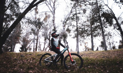
SaveCalifornia is the home of mountain biking. From Mt. Tamalpais in Marin, to Santa Cruz, to Downieville, to Tahoe, to southern California, the terrain and options in this state are virtually limitless. Smooth paths, flowy fun, rocky drops, treacherous gnar, and extreme tech punctuate hundreds of trail systems and riding parks. There is something for everyone in the Golden State.
Stats
- Avg Trail Rating
- Trails (view details)
- 24,990
- Trails Mountain Bike
- 17,360
- Trails E-Bike
- 6,351
- Trails Gravel Bike
- 7,776
- Trails Adaptive Bike
- 3,567
- Trails Winter Fat Bike
- 1,717
- Trails Horse
- 5,668
- Trails Hike
- 21,655
- Trails Trail Running
- 21,441
- Trails Dirtbike/Moto
- 1,655
- Trails Observed Trials
- 107
- Trails ATV/ORV/OHV
- 1,130
- Trails Snowmobile
- 62
- Trails Snowshoe
- 249
- Trails Downhill Ski
- 1,604
- Trails Backcountry Ski
- 151
- Trails Nordic Ski
- 370
- Total Distance
- 35,540 miles
- Total Descent
- 1,213 miles
- Total Vertical
- 14,477 ft
- Highest Trailhead
- 14,478 ft
- Reports
- 149,727
- Photos
- 60,407
- Ridden Counter
- 4,135,656
Articles
Video: Dane Jewett, Alden Pate, & Ryan Griffith Get Loose in 'Karaoke'
May 27, 2026 from pinkbike.com
Escaping the rainy PNW winter, the crew heads south to SoCal for a high-speed desert road trip that culminates in a late-night singing session.
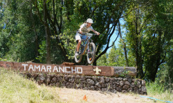
Marinduro 2026 Explodes to Become California’s Biggest Enduro Race
May 27, 2026 from pinkbike.com
Proving that local racing is thriving, 459 riders descend on Fairfax to race blind stages through the legendary, tacky dirt of Camp Tamarancho.
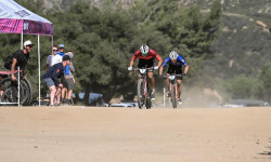
Elite Men & Women's XCO Race Replays from the 2026 US Cup Round 2
Apr 14, 2026 from pinkbike.com
All the action from round 2 of the US Pro Cup.
Video: Minivans, Surfboards, & Cali Dust: The Jamieson Brothers’ Pre-Season Road Trip
Apr 11, 2026 from pinkbike.com
From Auburn to Laguna Beach, Elliot and Nash Jamieson escape the PNW rain to dial in their 2026 setups and session with the Specialized Ride...
Popular Trail Networks
view all areas »Sub Regions
- Central California (337)
- Colusa County (9)
- Kings County (6)
- Lake County (88)
- Sacramento County (200)
- San Joaquin County (5)
- Stanislaus County (8)
- Sutter County (1)
- Yuba County (16)
- Central Coast (1,189)
- Monterey County (341)
- San Benito County (39)
- San Luis Obispo County (363)
- Santa Barbara County (233)
- Santa Cruz County (296)
- North Coast (592)
- Del Norte County (50)
- Humboldt County (216)
- Mendocino County (337)
- San Francisco Bay Area (4,217)
- Alameda County (697)
- Contra Costa County (755)
- Marin County (394)
- Napa County (247)
- San Francisco County (904)
- San Mateo County (324)
- Santa Clara County (695)
- Solano County (154)
- Sonoma County (325)
- Shasta Cascade (811)
- Butte County (208)
- Lassen County (94)
- Modoc County (3)
- Shasta County (230)
- Siskiyou County (174)
- Tehama County (28)
- Trinity County (67)
- Sierra Nevada (3,997)
- Alpine County (164)
- Amador County (29)
- Calaveras County (117)
- El Dorado County (605)
- Fresno County (82)
- Inyo County (225)
- Madera County (81)
- Mariposa County (67)
- Mono County (163)
- Nevada County (1,000)
- Placer County (668)
- Plumas County (356)
- Sierra County (175)
- Tulare County (95)
- Tulare County (13)
- Tuolumne County (246)
- Southern California (6,227)
- Imperial County (16)
- Kern County (521)
- Los Angeles County (1,314)
- Orange County (1,002)
- Riverside County (710)
- San Bernardino County (779)
- San Diego County (1,535)
- Ventura County (530)
- Upper Kings River Trails (0)
Popular California Mountain Biking Trails
• 95 ★ 4.6 • 5,151 ft • 19 ft • 5,979 •
Built specifically for mountain bikes, a emphasizes speed and rhythm, featuring berms, rollers, jumps and other features that are designed in a way that uses the rider’s momentum to minimize pedaling and braking (think downhill pump...
• 95 ★ 4.7 • 2,533 ft • 0 ft • 5,911 •
Built specifically for mountain bikes, a emphasizes speed and rhythm, featuring berms, rollers, jumps and other features that are designed in a way that uses the rider’s momentum to minimize pedaling and braking (think downhill pump...
• 95 ★ 4.7 • 1,496 ft • 0 ft • 5,885 •
Built specifically for mountain bikes, a emphasizes speed and rhythm, featuring berms, rollers, jumps and other features that are designed in a way that uses the rider’s momentum to minimize pedaling and braking (think downhill pump...
• 95 ★ 4.8 • 2,031 ft • 6 ft • 5,892 •
Built specifically for mountain bikes, a emphasizes speed and rhythm, featuring berms, rollers, jumps and other features that are designed in a way that uses the rider’s momentum to minimize pedaling and braking (think downhill pump...
• 95 ★ 4.7 • 2,392 ft • 10 ft • 5,855 •
Built specifically for mountain bikes, a emphasizes speed and rhythm, featuring berms, rollers, jumps and other features that are designed in a way that uses the rider’s momentum to minimize pedaling and braking (think downhill pump...
• 95 ★ 4.7 • 4,088 ft • 28 ft • 5,684 •
Built specifically for mountain bikes, a emphasizes speed and rhythm, featuring berms, rollers, jumps and other features that are designed in a way that uses the rider’s momentum to minimize pedaling and braking (think downhill pump...
• 95 ★ 4.7 • 2 miles • 137 ft • 4,925 •
is the launching point for most of the descents found in the Demo. All the DH trails start from , and connects them all at the top. It's a fun trail with lots of turns, a couple rock gardens, and a couple of Up-Pitches that test your...
• 100 ★ 3.9 • 4,491 ft • 3 ft • 4,656 •
Connects and the Fuel Break Road which leads up to Empire Grade (road). is a flowy, twisty trail which is narrow and can be dangerous if taken too fast or without proper guidance. High berms and fast descents punctuate tight turns and...
California Mountain Bike Routes
Waterdog Complete Loop Featured
★ 3.7 • 7 miles • 1,302 ft • 9 • Loop •
Nearly complete tour of the trails at Waterdog Lake Park. Can be ridden in either direction, but this way...
Oh, The Places You'll Go! Featured
★ 5.0 • 43 miles • 2,953 ft • 18 • Shuttled •
In his wonderful book, , it's doubtful that the beloved Dr. Seuss had mountain bikes in mind when he wrote...
Wondering Where the Lions Are Featured
★ 4.2 • 18 miles • 1,689 ft • 14 • Loop •
In Bruce Cockburn's wonderful , he sings about wondering where the lions are, which you may wonder...
Snake and Rice Canyon Loop Featured
★ 4.7 • 5 miles • 307 ft • 4 • Loop •
This central Chula Vista canyon loop route has been a favorite with trail users for years but only...
Here's Looking at You, Kid Featured
★ 5.0 • 14 miles • 646 ft • 8 • Shuttled •
This route is the kid brother to the famous . The latter is justifiably well known, given its epic descent...
TAMBA: Paradise Loop Featured
★ 4.0 • 11 miles • 816 ft • 15 • Loop •
The Paradise Loop is a fun new intermediate loop for the Tahoe Mountain Bike Festival. It is 11 miles long...
Photos of California Mountain Bike
Videos of California Mountain Bike
featured
![The Little Big 2013]()
5:27 |
2620 |
Jul 21, 2014

trail: Blue Blossom
2:17 |
1 |
Jun 20, 2026
0:07 |
5 |
May 27, 2026
trail: Lost Cannon Trail
0:03 |
8 |
May 27, 2026
trail: Beer Run
0:13 |
6 |
May 25, 2026
trail: Wayside Canyon Road
0:10 |
6 |
May 24, 2026

trail: Wayside Canyon Road
0:10 |
2 |
May 24, 2026
National Scenic Trails & Official Routes
-
Tahoe Rim Trail
- Mountain Bike
- E-Bike
- Horse
- Hike
- Trail Running
Activity Feed
| username | action | type | title | date |
|---|---|---|---|---|
| Biker6969haha | wishlist | region | activity #97720091 | Jun 24, 2026 @ 1:14pm 12 mins |
| Biker6969haha | wishlist | trail | activity #97719925 | Jun 24, 2026 @ 1:11pm 14 mins |
| lines | add | video | activity #97719496 | Jun 24, 2026 @ 1:05pm 20 mins |
| lines | add | video | activity #97719470 | Jun 24, 2026 @ 1:05pm 21 mins |
| AKwander | wishlist | route | activity #97719278 | Jun 24, 2026 @ 1:02pm 23 mins |
Recent Comments
| username | type | title | comment | date |
|---|---|---|---|---|
| trail | No longer accessible from the Bear Valley side... | Jun 24, 2026 @ 10:02am 3 hours | ||
| report | @karinarta: This is probably a question for... | Jun 24, 2026 @ 9:30am 4 hours | ||
| trail | I feel bad for my comments about the ruts,... | Jun 24, 2026 @ 8:46am 5 hours | ||
| report | No. So how should we handle it? The trail is... | Jun 24, 2026 @ 7:34am 6 hours | ||
| trail | Does this really need to be on trailforks? | Jun 23, 2026 @ 7:05pm 18 hours |
Local Badges
-
Sunset Loop3 awarded -

2026 Run the Rim 21k Finisher's Badge sponsored by Mountain Aloha MTB Co.0 awarded -
San Domingo Loop2 awarded -

Yabba Dabba Doo11 awarded -
Logging Museum Loop12 awarded -
Tahoe Mountain Bike Festival Triple Crown7 awarded
Bike & Skill Parks
| name | type | city | rating |
|---|---|---|---|
| Northstar at Tahoe Resort | bike park | Truckee | |
| Snow Summit Bike Park | bike park | Big Bear City | |
| Mammoth Mountain Bike Park | bike park | Mammoth Lakes | |
| SkyPark at Santa's Village | bike park | Skyforest | |
| Kirkwood Mountain Resort | bike park | Kirkwood |
Upcoming Local Events
Activity Type Stats
| activitytype | trails | distance | descent | descent distance | total vertical | rating | global rank | state rank | photos | reports | routes | ridelogs |
|---|---|---|---|---|---|---|---|---|---|---|---|---|
| Mountain Bike | 17,358 | 23,676 miles | 741 miles | 10,367 miles | 14,245 ft | #2 | 55,547 | 148,927 | 2,379 | 4,192,104 | ||
| E-Bike | 6,351 | 10,913 miles | 1,614,600 ft | 4,708 miles | 12,966 ft | #2 | 581 | 119,467 | 473 | 453,266 | ||
| Gravel Bike | 7,776 | 14,295 miles | 1,706,850 ft | 5,658 miles | 14,245 ft | #1 | 88 | 25,637 | 296 | 21,603 | ||
| Adaptive Bike | 3,567 | 6,334 miles | 743,842 ft | 2,430 miles | 14,245 ft | #1 | 10 | 30,422 | 60 | 240 | ||
| Winter Fat Bike | 1,717 | 2,097 miles | 304,288 ft | 895 miles | 10,978 ft | #6 | 12,785 | 3 | 94 | |||
| Horse | 5,668 | 13,167 miles | 2,007,267 ft | 5,552 miles | 13,114 ft | #1 | 29 | 32,394 | 134 | 581 | ||
| Hike | 21,640 | 33,176 miles | 1,037 miles | 14,006 miles | 14,478 ft | #1 | 3,526 | 145,991 | 1,669 | 361,402 | ||
| Trail Running | 21,441 | 32,875 miles | 1,027 miles | 13,895 miles | 14,478 ft | #1 | 308 | 145,810 | 1,243 | 232,129 | ||
| Dirtbike/Moto | 1,655 | 5,173 miles | 737,349 ft | 2,206 miles | 11,631 ft | #3 | 72 | 23,529 | 59 | 3,140 | ||
| Observed Trials | 107 | 207 miles | 25,482 ft | 90 miles | 10,400 ft | #2 | 12 | 1,320 | 1 | 762 | ||
| ATV/ORV/OHV | 1,130 | 3,455 miles | 448,825 ft | 1,405 miles | 11,631 ft | #3 | 35 | 22,594 | 34 | 747 | ||
| Snowmobile | 62 | 185 miles | 21,982 ft | 74 miles | 9,997 ft | #7 | 1 | 1,536 | 3 | 186 | ||
| Snowshoe | 249 | 400 miles | 52,165 ft | 146 miles | 14,137 ft | #13 | 7 | 1,938 | 37 | 3,288 | ||
| Downhill Ski | 1,604 | 552 miles | 477,136 ft | 502 miles | 10,938 ft | #3 | 8 | 809 | 1 | 68,651 | ||
| Backcountry Ski | 151 | 215 miles | 46,293 ft | 88 miles | 13,015 ft | #5 | 2 | 857 | 3 | 22,543 | ||
| Nordic Ski | 370 | 249 miles | 23,501 ft | 103 miles | 9,121 ft | #13 | 3 | 1,605 | 12 | 20,951 |
Activities
- California Mountain Biking Trails
- California E-Biking Trails
- California Gravel Biking Trails
- California Adaptive Biking Trails
- California Winter Fat Biking Trails
- California Horseback Trails
- California Hiking Trails
- California Trail Running Trails
- California Dirtbiking Trails
- California Observed Trials Trails
- California ATVing/Offroading Trails
- California Snowmobiling Trails
- California Snowshoeing Trails
- California Skiing Trails
- California Backcountry Skiing Trails
- California Nordic Skiing Trails
Trails
Points of Interest
- Marin Water District Sky Oaks Recreational Area Information
- Bridge and San Francisco Bay Viewpoint
- Mineral King Flume Viewpoint
- Holland Mountain (East) Information
- Holland Mountain (West) Information
- Top of climb/Rest spot Viewpoint
- SJR Bridge Sight
- Roys Redwoods Sight
- Alpine Dam Viewpoint
- Nike Site & viewpoint
- Mount Whitney (14,478 ft)
- Mount Williamson (14,383 ft)
- North Palisade (14,265 ft)
- By ryansimonovich
 & contributors
 - Admins: Map Team, IMBA, chuktA, msmcfate, WillieJacobsz, PlumbBobM, ReckitRolley, colinreuter, jpmcghee, sanfret
- #3106 - 230,450 views
- california activity log | embed map of California mountain bike trails | california mountain biking points of interest polygons
Downloading of trail gps tracks in kml & gpx formats is enabled for California.
You must login to download files.