close
-
Layers w
- Weather Layers
- Pro
- Pro
- Pro
- Pro
- Pro
- Pro
- More Layers
- Pro
- Pro
- Pro
- Pro
-
Upgrade to

3D
Trail Conditions
- Unknown
- Snow Groomed
- Snow Packed
- Snow Covered
- Snow Cover Partial
- Freeze/thaw Cycle
- Icy
- Prevalent Mud
- Wet
- Variable
- Ideal
- Dry
- Very Dry
Trail Flow (Ridden Direction)
Trailforks scans users ridelogs to determine the most popular direction each trail is ridden. A good flowing trail network will have most trails flowing in a single direction according to their intension.
The colour categories are based on what percentage of riders are riding a trail in its intended direction.
The colour categories are based on what percentage of riders are riding a trail in its intended direction.
- > 96%
- > 90%
- > 80%
- > 70%
- > 50%
- < 50%
- bi-directional trail
- no data
Trail Last Ridden
Trailforks scans ridelogs to determine the last time a trail was ridden.
- < 2 days
- < 1 week
- < 2 weeks
- < 1 month
- < 6 months
- > 6 months
Trail Ridden Direction
The intended direction a trail should be ridden.
- Downhill Only
- Downhill Primary
- Both Directions
- Uphill Primary
- Uphill Only
- One Direction
Contribute Details
Colors indicate trail is missing specified detail.
- Description
- Photos
- Description & Photos
- Videos
Trail Popularity ?
Trailforks scans ridelogs to determine which trails are ridden the most in the last 9 months.
Trails are compared with nearby trails in the same city region with a possible 25 colour shades.
Think of this as a heatmap, more rides = more kinetic energy = warmer colors.
- most popular
- popular
- less popular
- not popular
ATV/ORV/OHV Filter
Max Vehicle Width
inches
US Cell Coverage
Legend

Radar Time
Activity Recordings
Trailforks uses anonymized public activity data.
?
Activity Recordings
Trailforks uses anonymized public activity data.
?
Personal Heatmap
▶
Activity Types
all
/
none
▶
Options
2
Date range
month
–
Winter Trails
Warning
A routing network for winter maps does not exist. Selecting trails using the winter trails layer has been disabled.
Missing Trails
Most Popular
Least Popular
Trails are colored based on popularity. The more popular a trail is, the more red. Less popular trails trend towards green.
Jump Magnitude Heatmap
Heatmap of where riders jump on trails. Zoom in to see individual jumps, click circles to view jump details.
BC Backroad Status
![map legend]()
Service Road Atlas is a free to use, community-driven service for viewing and creating reports on the numerous back-country service roads around B.C. and Alberta.

Slope Aspect
Direction the slope faces
Trails Deemphasized
Trails are shown in grey.
Only show trails with no bike usage.
Suggested Layers
Based on selected activity type
Save the current map location and zoom level as your default home location whenever this page is loaded.
Save
No description for Calizzano has been added yet!
Login or register to submit one.
This region uses the Uk/Euro style trail grading system.
Activities Click to view
- Mountain Bike
4 trails
- E-Bike
2 trails
- Adaptive Bike
0 trails
- Winter Fat Bike
0 trails
- Hike
4 trails
- Trail Running
4 trails
Region Details
- 1
- 3
Region Status
Caution as of Jun 20, 2026Stats
- Avg Trail Rating
- Trails (view details)
- 4
- Trails Mountain Bike
- 4
- Trails E-Bike
- 2
- Trails Horse
- 1
- Trails Hike
- 4
- Trails Trail Running
- 4
- Total Distance
- 11 miles
- Total Descent
- 5,429 ft
- Total Vertical
- 1,815 ft
- Highest Trailhead
- 4,096 ft
- Reports
- 112
- Photos
- 27
- Ridden Counter
- 1,352
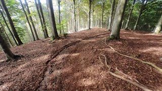
Popular Calizzano Mountain Biking Trails
• 100 ★ 4.0 • 2 miles • 131 ft • 442 •
Highly rated popular blue difficulty singletrack. This mountain bike primary trail can be used downhill primary and has a moderate overall physical rating with a 131 ft blue climb. It features roller coaster. On average it takes 18 minutes to complete this trail.
Photos of Calizzano Mountain Bike
Videos of Calizzano Mountain Bike
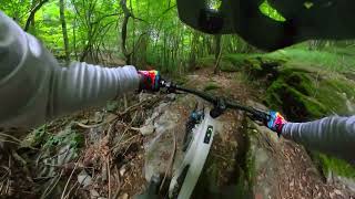
trail: Cormore
157 |
Jul 12, 2025 , Calizzano

trail: Rientro
14:58 |
128 |
Aug 22, 2024 , Calizzano
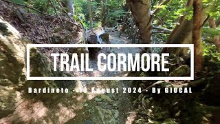
trail: Cormore
16:38 |
218 |
Aug 12, 2024 , Calizzano
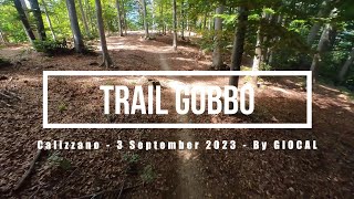
trail: Gobbo
8:50 |
330 |
Sep 20, 2023 , Calizzano
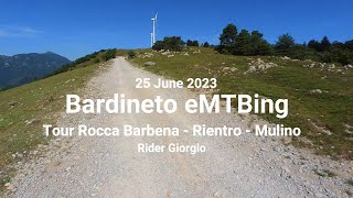
trail: Rientro
22:41 |
174 |
Jun 29, 2023 , Calizzano
trail: Cormore
12:51 |
509 |
Sep 7, 2022 , Calizzano
trail: Gobbo
17:56 |
298 |
Jun 29, 2022 , Calizzano
Recent Trail Reports
| status | trail | date | condition | info | user |
|---|---|---|---|---|---|
| Rientro | Jun 20, 2026 @ 7:05am (America/Vancouver) Jun 20, 2026 | Very Dry | alealegazza | ||
| Cormore | May 22, 2026 @ 10:18am (America/Vancouver) May 22, 2026 | Ideal | atrainofficial321 | ||
| Gobbo | Apr 27, 2026 @ 9:20am (America/Vancouver) Apr 27, 2026 | Unknown | Werner73 | ||
| Bric Schenasso - Piazzale sotto Bric Agrifoglio | Mar 21, 2026 @ 11:43pm (Europe/Rome) Mar 21, 2026 | Variable | alealegazza |
Activity Feed
| username | action | type | title | date |
|---|---|---|---|---|
| alealegazza | add | report | activity #97390953 | Jun 20, 2026 @ 7:05am Jun 20, 2026 |
| Froank | wishlist | trail | activity #97039236 | Jun 15, 2026 @ 7:16am Jun 15, 2026 |
| TNousy | wishlist | trail | activity #96216456 | Jun 4, 2026 @ 4:21am Jun 4, 2026 |
| Third-3ye | vote | trail | activity #95971629 | May 31, 2026 @ 1:08pm May 31, 2026 |
| HPWin | wishlist | trail | activity #95703303 | May 28, 2026 @ 6:40am May 28, 2026 |
Recent Comments
| username | type | title | comment | date |
|---|---|---|---|---|
| report | This trail and those in Bardineto will be... | Nov 22, 2025 @ 11:37am Nov 22, 2025 | ||
| trail | Phenomenal trail from the top to the bottom. ... | Oct 14, 2025 @ 2:50am Oct 14, 2025 | ||
| trail | Grazie per la linea, perfetto Trailbuilders | Oct 12, 2025 @ 3:58am Oct 12, 2025 | ||
| trail | Perfect! From top to bottom!!!! | Oct 8, 2025 @ 3:18am Oct 8, 2025 | ||
| trail | Se una volta era semi abbandonato, ora è... | Jul 19, 2025 @ 4:02am Jul 19, 2025 |
Activity Type Stats
| activitytype | trails | distance | descent | descent distance | total vertical | rating | global rank | state rank | photos | reports | routes | ridelogs |
|---|---|---|---|---|---|---|---|---|---|---|---|---|
| Mountain Bike | 4 | 11 miles | 5,430 ft | 8 miles | 1,814 ft | #4,879 | #343 | 27 | 112 | 940 | ||
| E-Bike | 2 | 6 miles | 2,011 ft | 4 miles | 1,453 ft | #7,394 | #804 | 61 | 65 | |||
| Horse | 1 | 3 miles | 479 ft | 1 mile | 400 ft | 10 | ||||||
| Hike | 4 | 11 miles | 5,430 ft | 8 miles | 1,814 ft | #9,583 | #652 | 112 | 18 | |||
| Trail Running | 4 | 11 miles | 5,430 ft | 8 miles | 1,814 ft | #9,081 | #630 | 112 |
- By denitopia
 TRAILFORKS VTA & contributors
 - Admins: denitopia
- #8633 - 3,051 views
- calizzano activity log | embed map of Calizzano mountain bike trails |
Downloading of trail gps tracks in kml & gpx formats is enabled for Calizzano.
You must login to download files.