close
-
Layers w
- Weather Layers
- Pro
- Pro
- Pro
- Pro
- Pro
- Pro
- More Layers
- Pro
- Pro
- Pro
- Pro
-
Upgrade to

3D
Trail Conditions
- Unknown
- Snow Groomed
- Snow Packed
- Snow Covered
- Snow Cover Partial
- Freeze/thaw Cycle
- Icy
- Prevalent Mud
- Wet
- Variable
- Ideal
- Dry
- Very Dry
Trail Flow (Ridden Direction)
Trailforks scans users ridelogs to determine the most popular direction each trail is ridden. A good flowing trail network will have most trails flowing in a single direction according to their intension.
The colour categories are based on what percentage of riders are riding a trail in its intended direction.
The colour categories are based on what percentage of riders are riding a trail in its intended direction.
- > 96%
- > 90%
- > 80%
- > 70%
- > 50%
- < 50%
- bi-directional trail
- no data
Trail Last Ridden
Trailforks scans ridelogs to determine the last time a trail was ridden.
- < 2 days
- < 1 week
- < 2 weeks
- < 1 month
- < 6 months
- > 6 months
Trail Ridden Direction
The intended direction a trail should be ridden.
- Downhill Only
- Downhill Primary
- Both Directions
- Uphill Primary
- Uphill Only
- One Direction
Contribute Details
Colors indicate trail is missing specified detail.
- Description
- Photos
- Description & Photos
- Videos
Trail Popularity ?
Trailforks scans ridelogs to determine which trails are ridden the most in the last 9 months.
Trails are compared with nearby trails in the same city region with a possible 25 colour shades.
Think of this as a heatmap, more rides = more kinetic energy = warmer colors.
- most popular
- popular
- less popular
- not popular
ATV/ORV/OHV Filter
Max Vehicle Width
inches
US Cell Coverage
Legend

Radar Time
Activity Recordings
Trailforks uses anonymized public activity data.
?
Activity Recordings
Trailforks uses anonymized public activity data.
?
Personal Heatmap
▶
Activity Types
all
/
none
▶
Options
2
Date range
month
–
Winter Trails
Warning
A routing network for winter maps does not exist. Selecting trails using the winter trails layer has been disabled.
Missing Trails
Most Popular
Least Popular
Trails are colored based on popularity. The more popular a trail is, the more red. Less popular trails trend towards green.
Jump Magnitude Heatmap
Heatmap of where riders jump on trails. Zoom in to see individual jumps, click circles to view jump details.
BC Backroad Status
![map legend]()
Service Road Atlas is a free to use, community-driven service for viewing and creating reports on the numerous back-country service roads around B.C. and Alberta.

Slope Aspect
Direction the slope faces
Trails Deemphasized
Trails are shown in grey.
Only show trails with no bike usage.
Suggested Layers
Based on selected activity type
Save the current map location and zoom level as your default home location whenever this page is loaded.
Save
No description for Cambridge has been added yet!
Login or register to submit one.
This region uses the Uk/Euro style trail grading system.
Activities Click to view
- Mountain Bike
27 trails
- E-Bike
21 trails
- Adaptive Bike
0 trails
- Horse
18 trails
- Hike
28 trails
- Trail Running
28 trails
Region Details
- 10
- 16
- 1
Region Status
Caution as of Jun 14, 2026Stats
- Avg Trail Rating
- Trails (view details)
- 27
- Trails Mountain Bike
- 27
- Trails E-Bike
- 21
- Trails Horse
- 18
- Trails Hike
- 28
- Trails Trail Running
- 28
- Total Distance
- 35 miles
- Total Descent
- 1,456 ft
- Total Vertical
- 394 ft
- Highest Trailhead
- 434 ft
- Reports
- 18
- Photos
- 4
- Ridden Counter
- 265
Popular Cambridge Mountain Biking Trails
• 85 ★ 4.0 • 2 miles • 85 ft • 16 •
Popular green difficulty family friendly singletrack. This multi-use trail can be used both directions and has a easy overall physical rating. On average it takes 9 minutes to complete this trail.
• 75 ★ 0.0 • 2 miles • 102 ft • 15 •
Popular green difficulty family friendly mixed. This multi-use trail can be used both directions and has a easy overall physical rating. On average it takes 1 hour45 minutes to complete this trail.
• 85 ★ 0.0 • 2 miles • 44 ft • 14 • • hike
Popular green difficulty singletrack. This hike primary trail can be used both directions. On average it takes 11 minutes to complete this trail.
• 100 ★ 0.0 • 3,642 ft • 22 ft • 11 •
Popular green difficulty singletrack. This multi-use trail can be used both directions. On average it takes 3 minutes to complete this trail.
• 55 ★ 0.0 • 2 miles • 62 ft • 8 •
Moderately popular green difficulty family friendly mixed. This multi-use trail can be used both directions and has a easy overall physical rating. On average it takes 7 minutes to complete this trail.
• 45 ★ 0.0 • 2,762 ft • 36 ft • 7 •
Moderately popular green difficulty mixed. This multi-use trail can be used both directions and has a easy overall physical rating. On average it takes 4 minutes to complete this trail.
• 50 ★ 0.0 • 4,892 ft • 8 ft • 6 •
Moderately popular green difficulty family friendly mixed. This multi-use trail can be used both directions and has a easy overall physical rating. Trail visibility is always easy to follow.
• 70 ★ 0.0 • 2 miles • 212 ft • 6 •
Popular green difficulty family friendly mixed. This multi-use trail can be used both directions and has a easy overall physical rating. Trail visibility is always easy to follow. On average it takes 16 minutes to complete this trail.
Videos of Cambridge Mountain Bike

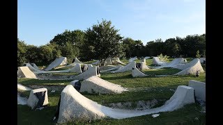
trail: Histon dirt jumps
0:49 |
1233 |
Jan 19, 2018 , Cambridge
1312 |
Jul 21, 2017
Current Trail Warnings
| status | trail | date | condition | user | info |
|---|---|---|---|---|---|
| Histon dirt jumps | Jun 14, 2026 @ 8:55am (Europe/London) Jun 14, 2026 | Unknown | taynton | could not find, I don't they they exist... |
Recent Trail Reports
| status | trail | date | condition | info | user |
|---|---|---|---|---|---|
| The Roman Road | Oct 20, 2025 @ 10:09am (Europe/London) Oct 20, 2025 | Unknown | eRBA3 | ||
| Rivey hill mainline | Dec 6, 2020 @ 9:17am Dec 6, 2020 | Wet | John93 | ||
| Barn Storm | May 26, 2019 @ 7:16am May 26, 2019 | Dry | Bennybeanbag |
Activity Feed
| username | action | type | title | date |
|---|---|---|---|---|
| taynton | add | report | activity #96943418 | Jun 14, 2026 @ 12:55am Jun 14, 2026 |
| Jamesyhtlsk | wishlist | region | activity #96866210 | Jun 13, 2026 @ 5:37am Jun 13, 2026 |
| grizzybobo | wishlist | region | activity #91476860 | Mar 28, 2026 @ 3:31pm Mar 28, 2026 |
| eRBA3 | add | report | activity #82700591 | Oct 20, 2025 @ 2:09am Oct 20, 2025 |
| joeg885 | add | report | activity #78405519 | Aug 18, 2025 @ 6:29am Aug 18, 2025 |
Recent Comments
| username | type | title | comment | date |
|---|---|---|---|---|
| trail | Think these are inaccessible now, private farm... | Apr 2, 2023 @ 8:08am Apr 2, 2023 | ||
| trail | Anybody wanna rebuild these? Email me at ... | Nov 26, 2020 @ 8:21am Nov 26, 2020 | ||
| trail | Yo bert. Local lad. Looking to rebuild these... | Mar 1, 2020 @ 10:47pm Mar 1, 2020 | ||
| trail | Not been (yet) but happy to lend a hand moving... | Feb 10, 2020 @ 2:26am Feb 10, 2020 |
Local Badges
-

Epic Mountain Bike Climb 2k5 awarded -

Climbing 10k Badge14 awarded -

Mountain Biking 100k Badge0 awarded -

Epic Ride Descent 2k5 awarded -

Descent 10k Badge14 awarded -

Descent 100k Badge0 awarded
Bike & Skill Parks
| name | type | city | rating |
|---|---|---|---|
| The Woodyard | skill park | Cambridge | |
| Milton Country Park Pump Track | skill park | Cambridge | |
| Trumpington pump track | skill park | Cambridge |
Local Mountain Biking Directory
-
BillysBike Shop
-
PedalbergBike Shop
-
Edencycles.comBike Shop
Activity Type Stats
| activitytype | trails | distance | descent | descent distance | total vertical | rating | global rank | state rank | photos | reports | routes | ridelogs |
|---|---|---|---|---|---|---|---|---|---|---|---|---|
| Mountain Bike | 27 | 35 miles | 1,457 ft | 14 miles | 394 ft | #7,578 | #281 | 4 | 18 | 10,238 | ||
| E-Bike | 21 | 31 miles | 1,391 ft | 13 miles | 374 ft | #2,685 | #96 | 15 | 175 | |||
| Horse | 18 | 27 miles | 1,234 ft | 12 miles | 374 ft | #769 | #30 | 8 | ||||
| Hike | 28 | 35 miles | 1,457 ft | 14 miles | 394 ft | #4,122 | #93 | 18 | 121 | |||
| Trail Running | 28 | 35 miles | 1,457 ft | 14 miles | 394 ft | #3,643 | #81 | 18 | 90 |
Frequently Asked Questions About Cambridge
▼
What are the highest rated mountain biking trails in Cambridge?
The highest rated mountain biking trails in Cambridge are:
- Bridleway (4/5)
- Rivey hill mainline (3.8/5)
- Histon dirt jumps (3.7/5)
- Trail (0/5)
- Trail (0/5)
▼
What is the best time of the year to ride in Cambridge?
Based on ride log data, the most popular months to ride in Cambridge are:
- September (15 activities)
- December (6 activities)
- July (3 activities)
▼
Where can I park to ride in Cambridge?
Check the Cambridge trail map for trailhead and parking information. Community members regularly update access and parking details for trails in the area.
▼
What is the longest trail in Cambridge?
The longest trail in Cambridge is Trail at 4.0 km. View all trails sorted by distance.
- By brahoy & contributors
- Admins: wisey, MathieuC, cemoorelife
- #7664 - 10,377 views
- cambridge activity log | embed map of Cambridge mountain bike trails |
Downloading of trail gps tracks in kml & gpx formats is enabled for Cambridge.
You must login to download files.