close
-
Layers w
- Weather Layers
- Pro
- Pro
- Pro
- Pro
- Pro
- Pro
- More Layers
- Pro
- Pro
- Pro
- Pro
-
Upgrade to

3D
Trail Conditions
- Unknown
- Snow Groomed
- Snow Packed
- Snow Covered
- Snow Cover Partial
- Freeze/thaw Cycle
- Icy
- Prevalent Mud
- Wet
- Variable
- Ideal
- Dry
- Very Dry
Trail Flow (Ridden Direction)
Trailforks scans users ridelogs to determine the most popular direction each trail is ridden. A good flowing trail network will have most trails flowing in a single direction according to their intension.
The colour categories are based on what percentage of riders are riding a trail in its intended direction.
The colour categories are based on what percentage of riders are riding a trail in its intended direction.
- > 96%
- > 90%
- > 80%
- > 70%
- > 50%
- < 50%
- bi-directional trail
- no data
Trail Last Ridden
Trailforks scans ridelogs to determine the last time a trail was ridden.
- < 2 days
- < 1 week
- < 2 weeks
- < 1 month
- < 6 months
- > 6 months
Trail Ridden Direction
The intended direction a trail should be ridden.
- Downhill Only
- Downhill Primary
- Both Directions
- Uphill Primary
- Uphill Only
- One Direction
Contribute Details
Colors indicate trail is missing specified detail.
- Description
- Photos
- Description & Photos
- Videos
Trail Popularity ?
Trailforks scans ridelogs to determine which trails are ridden the most in the last 9 months.
Trails are compared with nearby trails in the same city region with a possible 25 colour shades.
Think of this as a heatmap, more rides = more kinetic energy = warmer colors.
- most popular
- popular
- less popular
- not popular
ATV/ORV/OHV Filter
Max Vehicle Width
inches
US Cell Coverage
Legend

Radar Time
Activity Recordings
Trailforks uses anonymized public activity data.
?
Activity Recordings
Trailforks uses anonymized public activity data.
?
Personal Heatmap
▶
Activity Types
all
/
none
▶
Options
2
Date range
month
–
Winter Trails
Warning
A routing network for winter maps does not exist. Selecting trails using the winter trails layer has been disabled.
Missing Trails
Most Popular
Least Popular
Trails are colored based on popularity. The more popular a trail is, the more red. Less popular trails trend towards green.
Jump Magnitude Heatmap
Heatmap of where riders jump on trails. Zoom in to see individual jumps, click circles to view jump details.
BC Backroad Status
![map legend]()
Service Road Atlas is a free to use, community-driven service for viewing and creating reports on the numerous back-country service roads around B.C. and Alberta.

Slope Aspect
Direction the slope faces
Trails Deemphasized
Trails are shown in grey.
Only show trails with no bike usage.
Suggested Layers
Based on selected activity type
Save the current map location and zoom level as your default home location whenever this page is loaded.
SaveBoth paved and off-road bicycle trails are available. The paved trails run along the old roadbed of Old Dixie Highway, for about two miles. The Camp Murphy Off-road Bicycle Trail System is a nine-mile network of mountain bike trails, with loops rated for beginners all the way to "black diamond, experts only." Bicycles may be rented at the River Store. Helmets are highly recommended for all cyclists and Florida law requires helmets for cyclists age 16 and under.
Primary Trail Type: Cross-Country
AKA: Jonathan Dickinson State Park
 google parking directions
 Activities Click to view
- Mountain Bike
36 trails
- Hike
6 trails
- Trail Running
6 trails
Region Details
- 6
- 8
- 14
- 6
Region Status
Open as of Jun 12, 2026Local Trail Association
Stats
- Avg Trail Rating
- Trails (view details)
- 34
- Trails Mountain Bike
- 36
- Trails Hike
- 6
- Trails Trail Running
- 6
- Total Distance
- 14 miles
- Total Descent
- 517 ft
- Total Vertical
- 27 ft
- Highest Trailhead
- 29 ft
- Reports
- 1,551
- Photos
- 183
- Ridden Counter
- 22,625
Popular Camp Murphy Mountain Biking Trails
• 100 ★ 4.4 • 4,265 ft • 11 ft • 1,040 •
Beginning is fast and technical flow section (the Coaster) with lots of jumps and berms wherever there is a downhill. Hardpack in all but a few spots.
• 95 ★ 4.8 • 1,739 ft • 5 ft • 1,020 •
Major refurb 2019: Small step-ups through s-berms continuing as uphill rhythm section; "Snakepit" section enhanced and widened for safety; All wooden ladders removed and replaced with hardpack; Climb resurfaced; Big DHhas bermed roll-in...
• 90 ★ 4.5 • 3,953 ft • 26 ft • 1,000 •
The trail that begins it all. You might feel like a starting out with a climb on cold legs. Hardpack all the way with a few optional jumps to get your blood pumping. The end is called Yellow Brick Road on top of a low ridge featuring...
• 100 ★ 4.0 • 3,084 ft • 13 ft • 986 •
Major refurb FEB 2020: New entry directly across from exit (Be careful crossing road!) All wood ladders removed and replaced with hard pack. Featuring a lilypad jump, a double, a DH with two step-downs, a jumpable bridge, and a small...
• 90 ★ 4.3 • 3,119 ft • 58 ft • 981 •
Fun, flowy trail that is hardpack all the way. Starts off with a gentle downhill with six table tops of increasing length (8-16 ft) and a few berms to rocket you up the next climb. There is also a huge sand pit that can be traversed by...
• 95 ★ 4.7 • 3,458 ft • 33 ft • 976 •
The final trail before reaching the trailhead (unless you take the option toward the end). Hardpack throughout, fast and flowing. Features several optional concrete foundation crossings. The last little downhill is a fast and fun way to...
• 75 ★ 2.0 • 1,985 ft • 4 ft • 941 •
First half is still natural surface, i.e. sand. With enough moisture, it is quite ridable and fun, but when dry, it is a slog. At the end is an open area with three long skinnies of varying difficulty. These can be skipped by staying...
Camp Murphy Mountain Bike Routes
1 mile • 31 ft • 1 • Loop •
The Loop is an easy loop suitable for beginners.
• 13 miles • 341 ft • 30 •
• 18 miles • 517 ft • 48 •
• 25 miles • 494 ft • 52 •
• 12 miles • 338 ft • 31 •
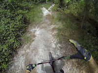
Photos of Camp Murphy Mountain Bike
Videos of Camp Murphy Mountain Bike

trail: Lake
0:59 |
401 |
Apr 22, 2014
trail: Lake
0:17 |
399 |
Dec 25, 2013
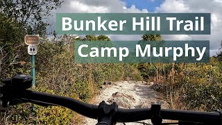
trail: Bunker Hill
10:18 |
96 |
Oct 22, 2025 , Hobe Sound
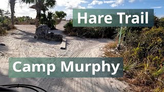
trail: Hare
4:44 |
42 |
Oct 22, 2025 , Hobe Sound
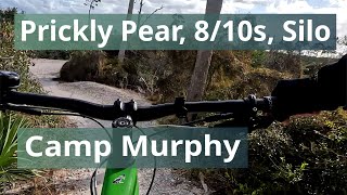
trail: Prickly Pear
9:29 |
30 |
Oct 22, 2025 , Hobe Sound
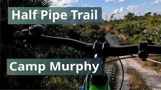
trail: Half Pipe
0:32 |
71 |
Oct 16, 2025 , Hobe Sound
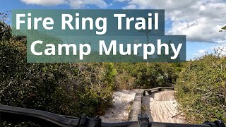
trail: Fire Ring
5:43 |
71 |
Oct 16, 2025 , Hobe Sound
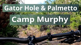
trail: Palmetto
5:04 |
45 |
Oct 12, 2025 , Hobe Sound
Recent Trail Reports
| status | trail | date | condition | info | user |
|---|---|---|---|---|---|
| Hare | May 30, 2026 @ 10:20am (America/Nassau) May 30, 2026 | Dry | ridelisaride | ||
| Sand Pit Bypass | May 30, 2026 @ 10:20am (America/Nassau) May 30, 2026 | Very Dry | ridelisaride | ||
| Fire Ring | May 30, 2026 @ 10:20am (America/Nassau) May 30, 2026 | Variable | ridelisaride | ||
| Palmetto | May 30, 2026 @ 10:20am (America/Nassau) May 30, 2026 | Variable | ridelisaride | ||
| Big Burn | May 30, 2026 @ 10:20am (America/Nassau) May 30, 2026 | Variable | ridelisaride | ||
| Doe | May 30, 2026 @ 10:20am (America/Nassau) May 30, 2026 | Snow Packed | ridelisaride | ||
| Root Loop | May 30, 2026 @ 10:20am (America/Nassau) May 30, 2026 | Variable | ridelisaride | ||
| Middle Ridge | May 30, 2026 @ 10:20am (America/Nassau) May 30, 2026 | Variable | ridelisaride | ||
| Lake | May 30, 2026 @ 10:20am (America/Nassau) May 30, 2026 | Ideal | ridelisaride | ||
| Walden | Apr 22, 2026 @ 9:50pm (America/New_York) Apr 22, 2026 | Very Dry | falcon013 |
Activity Feed
| username | action | type | title | date |
|---|---|---|---|---|
| erikasp03 | wishlist | region | activity #96583850 | Jun 8, 2026 @ 9:03pm Jun 8, 2026 |
| Edwinner23 | wishlist | region | activity #95994014 | May 31, 2026 @ 6:58pm May 31, 2026 |
| ridelisaride | add | report | activity #95933824 and 8 more | May 31, 2026 @ 6:34am May 31, 2026 |
| valko206 | add | photo | activity #94953741 | May 17, 2026 @ 6:05pm May 17, 2026 |
| valko206 | add | report | activity #94944538 and 1 more | May 17, 2026 @ 3:19pm May 17, 2026 |
Recent Comments
| username | type | title | comment | date |
|---|---|---|---|---|
| report | Sandy | Mar 23, 2025 @ 6:53am Mar 23, 2025 | ||
| trail | Really liked the trails here as my first ride... | May 9, 2023 @ 6:14pm May 9, 2023 | ||
| trail | Road this on a cyclocross bike and it was a... | May 9, 2023 @ 6:12pm May 9, 2023 | ||
| report | 12/23/2021 Trail is rideable and fun BUT could... | Dec 23, 2021 @ 4:16pm Dec 23, 2021 | ||
| report | Sorry, I meant it is closed at HARE ACCESS | Jun 13, 2020 @ 1:52pm Jun 13, 2020 |
Nearby Areas
| name | distance | ||||
|---|---|---|---|---|---|
| Jonathan Dickinson State Park | 8 | 3.6 km | |||
| Cypress Creek Natural Area | 2 | 6.5 km | |||
| Riverbend Park | 1 | 6.8 km | |||
| Halpatiokee Regional Park | 14 | 4 | 11.2 km | ||
| Dyer Hill | 6 | 18 | 4 | 15 km |
Local Badges
-

Completionist61 awarded
Bike & Skill Parks
| name | type | city | rating |
|---|---|---|---|
| Pumptrack | skill park | Hobe Sound | |
| Trail Head Skills Park | skill park | Hobe Sound | |
| Half Pipe Skills Area | skill park | Hobe Sound |
Activity Type Stats
| activitytype | trails | distance | descent | descent distance | total vertical | rating | global rank | state rank | photos | reports | routes | ridelogs |
|---|---|---|---|---|---|---|---|---|---|---|---|---|
| Mountain Bike | 36 | 14 miles | 518 ft | 4 miles | 26 ft | #159 | #56 | 185 | 1,551 | 2 | 18,583 | |
| Hike | 6 | 3 miles | 75 ft | 1 mile | 16 ft | #9,689 | #3,747 | 1,479 | 64 | |||
| Trail Running | 6 | 3 miles | 75 ft | 1 mile | 16 ft | #8,779 | #3,104 | 1,479 | 62 |
Frequently Asked Questions About Camp Murphy
▼
What are the highest rated mountain biking trails in Camp Murphy?
The highest rated mountain biking trails in Camp Murphy are:
- Lake (4.3/5)
- Bunker Hill (4.3/5)
- Hare (4.2/5)
- Ranger (4.2/5)
- Sand Pit Bypass (4.1/5)
▼
What is the best time of the year to ride in Camp Murphy?
Based on ride log data, the most popular months to ride in Camp Murphy are:
- December (180 activities)
- January (171 activities)
- February (157 activities)
▼
Where can I park to ride in Camp Murphy?
There are 1 parking locations listed in Camp Murphy. The most popular parking spots are:
▼
What is the longest trail in Camp Murphy?
The longest trail in Camp Murphy is Bunker Hill at 1.3 miles. View all trails sorted by distance.
Activities
- By blindstuff
 VKBC & contributors
 - Admins: Scrub, Twistedpine24
- #7611 - 24,215 views
- camp murphy activity log | embed map of Camp Murphy mountain bike trails | camp murphy mountain biking points of interest
Downloading of trail gps tracks in kml & gpx formats is enabled for Camp Murphy.
You must login to download files.