This region is closed or decommissioned.
close
-
Layers w
- Weather Layers
- Pro
- Pro
- Pro
- Pro
- Pro
- Pro
- More Layers
- Pro
- Pro
- Pro
- Pro
-
Upgrade to

3D
Trail Conditions
- Unknown
- Snow Groomed
- Snow Packed
- Snow Covered
- Snow Cover Partial
- Freeze/thaw Cycle
- Icy
- Prevalent Mud
- Wet
- Variable
- Ideal
- Dry
- Very Dry
Trail Flow (Ridden Direction)
Trailforks scans users ridelogs to determine the most popular direction each trail is ridden. A good flowing trail network will have most trails flowing in a single direction according to their intension.
The colour categories are based on what percentage of riders are riding a trail in its intended direction.
The colour categories are based on what percentage of riders are riding a trail in its intended direction.
- > 96%
- > 90%
- > 80%
- > 70%
- > 50%
- < 50%
- bi-directional trail
- no data
Trail Last Ridden
Trailforks scans ridelogs to determine the last time a trail was ridden.
- < 2 days
- < 1 week
- < 2 weeks
- < 1 month
- < 6 months
- > 6 months
Trail Ridden Direction
The intended direction a trail should be ridden.
- Downhill Only
- Downhill Primary
- Both Directions
- Uphill Primary
- Uphill Only
- One Direction
Contribute Details
Colors indicate trail is missing specified detail.
- Description
- Photos
- Description & Photos
- Videos
Trail Popularity ?
Trailforks scans ridelogs to determine which trails are ridden the most in the last 9 months.
Trails are compared with nearby trails in the same city region with a possible 25 colour shades.
Think of this as a heatmap, more rides = more kinetic energy = warmer colors.
- most popular
- popular
- less popular
- not popular
ATV/ORV/OHV Filter
Max Vehicle Width
inches
US Cell Coverage
Legend

Radar Time
Activity Recordings
Trailforks uses anonymized public activity data.
?
Activity Recordings
Trailforks uses anonymized public activity data.
?
Personal Heatmap
▶
Activity Types
all
/
none
▶
Options
2
Date range
month
–
Winter Trails
Warning
A routing network for winter maps does not exist. Selecting trails using the winter trails layer has been disabled.
Missing Trails
Most Popular
Least Popular
Trails are colored based on popularity. The more popular a trail is, the more red. Less popular trails trend towards green.
Jump Magnitude Heatmap
Heatmap of where riders jump on trails. Zoom in to see individual jumps, click circles to view jump details.
BC Backroad Status
![map legend]()
Service Road Atlas is a free to use, community-driven service for viewing and creating reports on the numerous back-country service roads around B.C. and Alberta.

Slope Aspect
Direction the slope faces
Trails Deemphasized
Trails are shown in grey.
Only show trails with no bike usage.
Suggested Layers
Based on selected activity type
Save the current map location and zoom level as your default home location whenever this page is loaded.
SaveThis region is Unsanctioned, Ride at your own Risk!
Camp Timberline has been closed to mountain biking at this point.
source: mtbhawaii.com
Primary Trail Type: All-Mountain & Downhill
Land Status: Private Property
Activities Click to view
- Mountain Bike
2 trails
Region Details
- 2
Region Status
Open as of Nov 3, 2019Stats
- Global Ranking
- #13,691
- State Ranking
- #5,545
- Trails (view details)
- 2
- Trails Mountain Bike
- 2
- Trails Hike
- 2
- Trails Trail Running
- 2
- Total Distance
- 1 mile
- Total Descent
- 1,150 ft
- Total Vertical
- 597 ft
- Highest Trailhead
- 2,314 ft
- Photos
- 16
- Ridden Counter
- 11
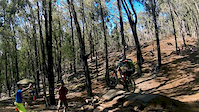
Photos of Camp Timberline Mountain Bike
Videos of Camp Timberline Mountain Bike
2:22 |
268 |
Oct 28, 2014

897 |
Jan 26, 2015 , Makakilo
Activity Feed
| username | action | type | title | date |
|---|---|---|---|---|
| WillieJacobsz | update | region | activity #40122284 | May 20, 2023 @ 5:26am May 20, 2023 |
| Rastis1 | add | photo | activity #2268337 | Jun 19, 2018 @ 7:44am Jun 19, 2018 |
| lucho8486 | wishlist | region | activity #1552204 | Jan 12, 2018 @ 11:51pm Jan 12, 2018 |
| Rastis1 | add | photo | activity #703558 | May 9, 2017 @ 7:10am May 9, 2017 |
| canadaka | add | video | activity #52615 | Jan 26, 2015 @ 11:20am Jan 26, 2015 |
Nearby Areas
| name | distance | ||||
|---|---|---|---|---|---|
| Makaha Valley | 3 | 9 km | |||
| Peacock Flats | 1 | 4 | 1 | 3 | 13.6 km |
| Ahupuaʻa ʻO Kahana State Park | 17.5 km | ||||
| Pupukea / Sunset Hills | 28 | 45 | 12 | 1 | 19.7 km |
| Kaaawa Valley | 20 km |
Activity Type Stats
| activitytype | trails | distance | descent | descent distance | total vertical | rating | global rank | state rank | photos | reports | routes | ridelogs |
|---|---|---|---|---|---|---|---|---|---|---|---|---|
| Mountain Bike | 2 | 1 mile | 1,148 ft | 1 mile | 597 ft | #13,691 | #5,545 | 16 | 252 | |||
| Hike | 2 | 1 mile | 1,148 ft | 1 mile | 597 ft | #5,426 | 30 | |||||
| Trail Running | 2 | 1 mile | 1,148 ft | 1 mile | 597 ft | #5,342 |
- By canadaka
 Trailforks & contributors
 - Admins: apply
- #3282 - 5,114 views
- camp timberline activity log | embed map of Camp Timberline mountain bike trails |
Downloading of trail gps tracks in kml & gpx formats is enabled for Camp Timberline.
You must login to download files.