close
-
Layers w
- Weather Layers
- Pro
- Pro
- Pro
- Pro
- Pro
- Pro
- More Layers
- Pro
- Pro
- Pro
- Pro
-
Upgrade to

3D
Trail Conditions
- Unknown
- Snow Groomed
- Snow Packed
- Snow Covered
- Snow Cover Partial
- Freeze/thaw Cycle
- Icy
- Prevalent Mud
- Wet
- Variable
- Ideal
- Dry
- Very Dry
Trail Flow (Ridden Direction)
Trailforks scans users ridelogs to determine the most popular direction each trail is ridden. A good flowing trail network will have most trails flowing in a single direction according to their intension.
The colour categories are based on what percentage of riders are riding a trail in its intended direction.
The colour categories are based on what percentage of riders are riding a trail in its intended direction.
- > 96%
- > 90%
- > 80%
- > 70%
- > 50%
- < 50%
- bi-directional trail
- no data
Trail Last Ridden
Trailforks scans ridelogs to determine the last time a trail was ridden.
- < 2 days
- < 1 week
- < 2 weeks
- < 1 month
- < 6 months
- > 6 months
Trail Ridden Direction
The intended direction a trail should be ridden.
- Downhill Only
- Downhill Primary
- Both Directions
- Uphill Primary
- Uphill Only
- One Direction
Contribute Details
Colors indicate trail is missing specified detail.
- Description
- Photos
- Description & Photos
- Videos
Trail Popularity ?
Trailforks scans ridelogs to determine which trails are ridden the most in the last 9 months.
Trails are compared with nearby trails in the same city region with a possible 25 colour shades.
Think of this as a heatmap, more rides = more kinetic energy = warmer colors.
- most popular
- popular
- less popular
- not popular
ATV/ORV/OHV Filter
Max Vehicle Width
inches
US Cell Coverage
Legend

Radar Time
Activity Recordings
Trailforks uses anonymized public activity data.
?
Activity Recordings
Trailforks uses anonymized public activity data.
?
Personal Heatmap
▶
Activity Types
all
/
none
▶
Options
2
Date range
month
–
Winter Trails
Warning
A routing network for winter maps does not exist. Selecting trails using the winter trails layer has been disabled.
Missing Trails
Most Popular
Least Popular
Trails are colored based on popularity. The more popular a trail is, the more red. Less popular trails trend towards green.
Jump Magnitude Heatmap
Heatmap of where riders jump on trails. Zoom in to see individual jumps, click circles to view jump details.
BC Backroad Status
![map legend]()
Service Road Atlas is a free to use, community-driven service for viewing and creating reports on the numerous back-country service roads around B.C. and Alberta.

Slope Aspect
Direction the slope faces
Trails Deemphasized
Trails are shown in grey.
Only show trails with no bike usage.
Suggested Layers
Based on selected activity type
Save the current map location and zoom level as your default home location whenever this page is loaded.
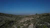
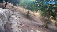
SaveThis is one of the more popular nature reserves in the country, located between the plain and the mountains, between Tel Aviv and Jerusalem. The reason for this: the right combination between nature and heritage, between archeology and walking trails, between open spaces and intimate groves. This place has everything of everything within an area of 7,000 dunams. Many scenic walking trails cross this park and it is simply recommended to lose oneself in them and find new places which one have not encountered in previous visits in this area. This region includes many remains from the past, such as burial caves, aqueduct, agricultural installations, structural ruins, hiding tunnels and more. All these are wrapped within a grove, forests and many picnic areas. Among the more popular sites are: Springs Valley, Tel Ayalon (Ayalon mound), the observation point hill and more. This park is very suitable for all level bicycle rides. Access from road number 1, through the Latrun intersection.
source: The Ayalon-Canada Park
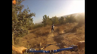
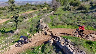
Primary Trail Type: All-Mountain & Downhill
AKA: פארק קנדה איילון
 google parking directions
This region uses the Uk/Euro style trail grading system.
Activities Click to view
- Mountain Bike
17 trails
- E-Bike
16 trails
- Hike
13 trails
- Trail Running
12 trails
Region Details
- 3
- 11
- 3
Region Status
Open as of Jun 7, 2026Stats
- Avg Trail Rating
- Trails (view details)
- 17
- Trails Mountain Bike
- 17
- Trails E-Bike
- 16
- Trails Hike
- 13
- Trails Trail Running
- 12
- Total Distance
- 19 miles
- Total Descent
- 3,435 ft
- Total Vertical
- 551 ft
- Highest Trailhead
- 1,293 ft
- Reports
- 227
- Photos
- 25
- Ridden Counter
- 2,957
Popular Canada Park Mountain Biking Trails
• 95 ★ 4.9 • 1 mile • 21 ft • 360 •
The trail (marked Black for orientation) features good gradient for both easy climbing and flowy descending, and takes great advantage of the natural, sometimes rocky terrain of the area. A good spot for riding and meeting riders, and...
• 100 ★ 4.7 • 3 miles • 531 ft • 360 •
Highly rated popular blue difficulty singletrack. This mountain bike primary trail can be used one direction. It features rock face and rock garden. On average it takes 33 minutes to complete this trail.
• 90 ★ 4.7 • 2 miles • 133 ft • 347 •
A technical and rocky trail, with good flow fun and speed
• 85 ★ 4.8 • 4 miles • 736 ft • 301 •
This Long trail features good flow on the descent with few technical sections, good speed and small berms. The climb back is on a moderate gradient that suites any rider.
• 80 ★ 4.0 • 2,262 ft • 31 ft • 298 •
Popular blue difficulty singletrack. This mountain bike primary trail can be used one direction. On average it takes 4 minutes to complete this trail.
• 50 ★ 4.3 • 1 mile • 53 ft • 164 •
A technical trail, rocky in the middle, and steep at the last section
• 60 ★ 0.0 • 1,470 ft • 3 ft • 116 •
Moderately popular blue difficulty singletrack. This mountain bike primary trail can be used both directions. On average it takes 2 minutes to complete this trail.
• 75 ★ 5.0 • 3,182 ft • 0 ft • 108 •
Popular blue difficulty singletrack. This mountain bike primary trail can be used downhill only. On average it takes 7 minutes to complete this trail.
Canada Park Mountain Bike Routes
11 miles • 1,196 ft • 4 •
=========== אימוני בוקר על המסלול לכל הקטגוריות ביום האירוע מ...
9 miles • 1,100 ft • 2 •
Pirates in Canada for all mountain rider that need something new
13 miles • 1,339 ft • 3 • Race •
מסלולי התחרות , הפרסה+השחור בפארק קנדה משלבים מהירות...
• 16 miles • 2,180 ft • 7 •
• 2 miles • 19 ft • 1 •
Photos of Canada Park Mountain Bike
Videos of Canada Park Mountain Bike
trail: Shwartz Memorial
3:29 |
117 |
Jan 2, 2023
trail: Ayalon - The Red
0:08 |
292 |
Aug 9, 2016
2:09 |
397 |
Sep 25, 2015

0:55 |
228 |
Jan 11, 2014

0:44 |
540 |
Mar 11, 2012

trail: The Black
0:58 |
219 |
May 20, 2010
trail: Ayalon - The Red
15:39 |
216 |
Feb 1, 2022 , My City

trail: Horseshoe
15:39 |
205 |
Feb 1, 2022 , My City
Recent Trail Reports
| status | trail | date | condition | info | user |
|---|---|---|---|---|---|
| The Black | May 23, 2026 @ 7:48am (Asia/Jerusalem) May 22, 2026 | Very Dry | Platipus | ||
| Bathtubs | May 23, 2026 @ 7:48am (Asia/Jerusalem) May 22, 2026 | Very Dry | Platipus | ||
| Ayalon - The Red | May 23, 2026 @ 7:48am (Asia/Jerusalem) May 22, 2026 | Very Dry | Platipus | ||
| Horseshoe | May 23, 2026 @ 7:48am (Asia/Jerusalem) May 22, 2026 | Very Dry | Platipus | ||
| The 7th Destiny | May 23, 2026 @ 7:48am (Asia/Jerusalem) May 22, 2026 | Very Dry | Platipus | ||
| LunaPark | Mar 15, 2025 @ 6:45am Mar 15, 2025 | Ideal | Alone-a | ||
| Switchbacks | Mar 3, 2023 @ 3:53pm Mar 3, 2023 | Dry | Basselq | ||
| Motorcycles | Mar 3, 2023 @ 3:53pm Mar 3, 2023 | Dry | Basselq | ||
| Western | Feb 9, 2023 @ 4:20pm Feb 9, 2023 | Variable | shacharLV | ||
| Beyond the fence | Nov 26, 2022 @ 2:16pm Nov 26, 2022 | Variable | Akira7 |
Activity Feed
| username | action | type | title | date |
|---|---|---|---|---|
| Platipus | add | report | activity #95309614 and 4 more | May 23, 2026 @ 6:01am May 23, 2026 |
| CGe9gL | wishlist | trail | activity #90106725 | Mar 7, 2026 @ 2:54am Mar 7, 2026 |
| Amir99jrvm | wishlist | route | activity #85641455 | Dec 16, 2025 @ 11:53pm Dec 16, 2025 |
| Amir99jrvm | wishlist | trail | activity #85641414 | Dec 16, 2025 @ 11:51pm Dec 16, 2025 |
| KP6Kgp9h | wishlist | route | activity #84662011 | Nov 24, 2025 @ 10:37am Nov 24, 2025 |
Recent Comments
| username | type | title | comment | date |
|---|---|---|---|---|
| trail | העתיקות | Mar 17, 2023 @ 6:44am Mar 17, 2023 | ||
| report | what do you mean ? | Nov 2, 2019 @ 1:56am Nov 2, 2019 | ||
| report | Ded | Oct 28, 2019 @ 6:22am Oct 28, 2019 | ||
| trail | Mostly downhill except a short but very punchy... | Aug 10, 2019 @ 5:59am Aug 10, 2019 | ||
| trail | Steep at the last portion, rocky in the middle | Nov 5, 2015 @ 2:13am Nov 5, 2015 |
Nearby Areas
| name | distance | ||||
|---|---|---|---|---|---|
| Neve Shalom | 1 | 2 km | |||
| Karmei Yosef | 2 | 8 | 4.2 km | ||
| Tsor'a | 3 | 4.8 km | |||
| Ben Shemen | 17 | 31 | 8.2 km | ||
| Srigim Li-on | 4 | 11.6 km |
Local Mountain Biking Directory
-
GALGALIM- PRO
![GALGALIM- PRO]()
-
Giant IsraelBike Shop
-
Slalum Beit HerutBike Shop
Local Products
Activity Type Stats
| activitytype | trails | distance | descent | descent distance | total vertical | rating | global rank | state rank | photos | reports | routes | ridelogs |
|---|---|---|---|---|---|---|---|---|---|---|---|---|
| Mountain Bike | 17 | 19 miles | 3,435 ft | 9 miles | 551 ft | #1,202 | #9 | 25 | 226 | 5 | 6,149 | |
| E-Bike | 16 | 19 miles | 3,248 ft | 9 miles | 551 ft | #983 | #16 | 211 | 1,523 | |||
| Hike | 13 | 18 miles | 2,920 ft | 8 miles | 551 ft | #1,803 | #15 | 226 | 23 | |||
| Trail Running | 12 | 17 miles | 2,690 ft | 8 miles | 551 ft | #1,150 | 226 | 10 |
Frequently Asked Questions About Canada Park
▼
What are the highest rated mountain biking trails in Canada Park?
The highest rated mountain biking trails in Canada Park are:
- The Black (4.5/5)
- Ayalon - The Red (4.4/5)
- The 7th Destiny (4.3/5)
- Horseshoe (4.3/5)
- Switchbacks (4.1/5)
▼
What is the best time of the year to ride in Canada Park?
Based on ride log data, the most popular months to ride in Canada Park are:
- December (22 activities)
- November (20 activities)
- February (17 activities)
▼
Where can I park to ride in Canada Park?
There are 1 parking locations listed in Canada Park. The most popular parking spots are:
▼
What is the longest trail in Canada Park?
The longest trail in Canada Park is Ayalon - The Red at 4.3 miles. View all trails sorted by distance.
Activities
- By ziv2102
 TRAILFORKS & contributors
 - Admins: ziv2102
- #5781 - 6,756 views
- canada park activity log | embed map of Canada Park mountain bike trails | canada park mountain biking points of interest
Downloading of trail gps tracks in kml & gpx formats is enabled for Canada Park.
You must login to download files.