close
-
Layers w
- Weather Layers
- Pro
- Pro
- Pro
- Pro
- Pro
- Pro
- More Layers
- Pro
- Pro
- Pro
- Pro
-
Upgrade to

3D
Trail Conditions
- Unknown
- Snow Groomed
- Snow Packed
- Snow Covered
- Snow Cover Partial
- Freeze/thaw Cycle
- Icy
- Prevalent Mud
- Wet
- Variable
- Ideal
- Dry
- Very Dry
Trail Flow (Ridden Direction)
Trailforks scans users ridelogs to determine the most popular direction each trail is ridden. A good flowing trail network will have most trails flowing in a single direction according to their intension.
The colour categories are based on what percentage of riders are riding a trail in its intended direction.
The colour categories are based on what percentage of riders are riding a trail in its intended direction.
- > 96%
- > 90%
- > 80%
- > 70%
- > 50%
- < 50%
- bi-directional trail
- no data
Trail Last Ridden
Trailforks scans ridelogs to determine the last time a trail was ridden.
- < 2 days
- < 1 week
- < 2 weeks
- < 1 month
- < 6 months
- > 6 months
Trail Ridden Direction
The intended direction a trail should be ridden.
- Downhill Only
- Downhill Primary
- Both Directions
- Uphill Primary
- Uphill Only
- One Direction
Contribute Details
Colors indicate trail is missing specified detail.
- Description
- Photos
- Description & Photos
- Videos
Trail Popularity ?
Trailforks scans ridelogs to determine which trails are ridden the most in the last 9 months.
Trails are compared with nearby trails in the same city region with a possible 25 colour shades.
Think of this as a heatmap, more rides = more kinetic energy = warmer colors.
- most popular
- popular
- less popular
- not popular
ATV/ORV/OHV Filter
Max Vehicle Width
inches
US Cell Coverage
Legend

Radar Time
Activity Recordings
Trailforks uses anonymized public activity data.
?
Activity Recordings
Trailforks uses anonymized public activity data.
?
Personal Heatmap
▶
Activity Types
all
/
none
▶
Options
2
Date range
month
–
Winter Trails
Warning
A routing network for winter maps does not exist. Selecting trails using the winter trails layer has been disabled.
Missing Trails
Most Popular
Least Popular
Trails are colored based on popularity. The more popular a trail is, the more red. Less popular trails trend towards green.
Jump Magnitude Heatmap
Heatmap of where riders jump on trails. Zoom in to see individual jumps, click circles to view jump details.
BC Backroad Status
![map legend]()
Service Road Atlas is a free to use, community-driven service for viewing and creating reports on the numerous back-country service roads around B.C. and Alberta.

Slope Aspect
Direction the slope faces
Trails Deemphasized
Trails are shown in grey.
Only show trails with no bike usage.
Suggested Layers
Based on selected activity type
Save the current map location and zoom level as your default home location whenever this page is loaded.
Save
No description for Canazei has been added yet!
Login or register to submit one.
This region uses the Uk/Euro style trail grading system.
Activities Click to view
- Mountain Bike
46 trails
- E-Bike
49 trails
- Gravel Bike
0 trails
- Adaptive Bike
0 trails
- Winter Fat Bike
0 trails
- Hike
27 trails
- Trail Running
28 trails
Region Details
- 14
- 1
- 6
- 12
- 5
- 4
- 3
Region Status
Caution as of 1 dayStats
- Avg Trail Rating
- Trails (view details)
- 51
- Trails Mountain Bike
- 46
- Trails E-Bike
- 49
- Trails Horse
- 1
- Trails Hike
- 27
- Trails Trail Running
- 28
- Total Distance
- 77 miles
- Total Descent Distance
- 52 miles
- Total Descent
- 25,080 ft
- Total Vertical
- 5,558 ft
- Highest Trailhead
- 8,264 ft
- Reports
- 3,058
- Photos
- 304
- Ridden Counter
- 40,558
Articles
Video: Jesse Melamed Gives Questionable Cooking Advice in Val di Fassa - The Jank Files S4E3
Jun 30, 2022 from pinkbike.com
The Rocky Mountain Race Face Team takes on the Dolomites, and .

Video: Red Bull's 'The Honest Truth About Competitive Bans in Enduro MTB' - On Track with Greg Callaghan
Aug 22, 2019 from pinkbike.com
Joining Greg Callaghan in Val di Fassa is Richie Rude.
The French Fellas on the Ethirteen Urge BP Enduro Team Take on EWS Val di Fassa & EWS Les Orres
Jul 31, 2019 from pinkbike.com
Ulysse Francoglio, Théo Daumas, Baptiste Gaillot and Clement Benoit tackle a couple of massive race days
Video: Melamed, Gauvin & Lanthier Nadeau Take on EWS Val di Fassa and Les Orres in Episode 3 of 'The Jank Files'
Jul 17, 2019 from pinkbike.com
From dirt kart racing and glacial river baths to podium finishes and the hospital visits. This isn’t your average Euro trip.
Sub Regions
-
Fassa Bike District
- 6
- 12
- 5
- 4
- 3
Popular Canazei Mountain Biking Trails
• 80 ★ 4.7 • 2 miles • 0 ft • 1,278 •
DIRECTION A natural trail that connects Campitello - Col Rodella Gondola to the Pian de Frataces area with the Pradel-Rodella Gondola and Pian Frataches - Gherdecia Gondola. DESCRIPTION The beginning features a very long and scenic...
• 50 ★ 3.8 • 2,251 ft • 0 ft • 1,271 •
DIRECTION: A line serving the Sellaronda MTB Tour (clockwise), from Campitello - Col Rodella Gondola to the Salei Refuge or return to Canazei by taking the RodeLine trail. DESCRIPTION: A flow trail with a worked surface, characterized...
• 100 ★ 3.6 • 1,919 ft • 3 ft • 1,214 •
DIRECTION Connection trail between Gluhwein or and the area with the Pian Frataces - Gherdecia or Pradel - Rodella gondolas. DESCRIPTION The trail in the first part is flow style with an alternative choice between a red and a blue line....
• 90 ★ 4.2 • 1,650 ft • 0 ft • 1,189 •
DIRECTION Flow trail split into 4 sections connecting the Salei Refuge to the Pian de Frataces with the Pradel - Rodella Gondola and Pian Frataces - Gherdecia Gondola. DESCRIPTION Long trail from Col Rodella, whose initial and final...
• 70 ★ 3.6 • 3 miles • 12 ft • 1,180 •
DIRECTION It's the longest line in the Fassa Bike Park: from Passo Pordoi to the town of Canazei. DESCRIPTION The first kilometer is very fast, but the presence of some technical passages requires caution. After the Hotel Pordoi pond,...
• 75 ★ 3.3 • 5,220 ft • 0 ft • 1,082 •
DIRECTION It is the continuation of route and connects the Fodom Refuge upstream (Arabba) to the downstream station of the Vauz - Pordoi cable car, in Pont de Vauz. DESCRIPTION A flow-style line on terrain with good grip, where banked...
• 90 ★ 4.7 • 1,900 ft • 0 ft • 1,040 •
DIRECTION Flow trail split into 4 sections connecting the Salei Refuge to the Pian de Frataces with the Pradel - Rodella Gondola and Pian Frataces - Gherdecia Gondola. DESCRIPTION Pleasant and fun artificial flow on compact soil with...
• 85 ★ 3.9 • 2,270 ft • 6 ft • 1,024 •
After the ski slope connector ( ), a short but steep climp gives access to a very fun mid-slope natural trail. CAUTION: This segmet is OPEN TO HIKERS in both directions
Canazei Mountain Bike Routes
16 miles • 3,002 ft • 0 • Loop •
Strada forestale che da Campitello sale in Val Duron, il primo pezzo salendo è bello ripido e poi si...
28 miles • 1,217 ft • 0 • Out & Back •
La ciclabile parte da Canazei e arriva fino a Molina, appena sotto a Cavalese, per la maggior parte è...
Photos of Canazei Mountain Bike
Videos of Canazei Mountain Bike
0:00 |
6 |
Sep 18, 2025
4:25 |
3 |
Sep 18, 2025
trail: Tutti Frutti
0:09 |
341 |
Jun 24, 2021
trail: Tutti Frutti
0:10 |
|
Jun 24, 2021
youtuber
![TUTTI FRUTTI ⚫ | Bikepark Canazei, Val di Fassa]()
trail: Tutti Frutti
7:41 |
169 |
Dec 6, 2025 , Canazei
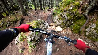

trail: Rabbe
17:57 |
32 |
Nov 25, 2025 , Canazei
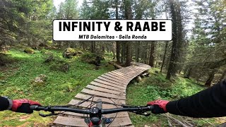
trail: Infinity
17:57 |
54 |
Nov 25, 2025 , Canazei
Current Trail Warnings
| status | trail | date | condition | user | info |
|---|---|---|---|---|---|
| 9.90 | Jun 18, 2026 @ 9:01am (Europe/Rome) 1 day | Ideal | ale_ssia FBD | Upper section open, lower section closed... | |
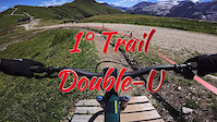
| Double U | Jun 13, 2026 @ 10:26am (Europe/Rome) Jun 13, 2026 | Variable | ale_ssia FBD | Under maintenance |
Recent Trail Reports
| status | trail | date | condition | info | user |
|---|---|---|---|---|---|
| Zacan - DoubleU Connector | Jun 18, 2026 @ 10:04am (Europe/Rome) 1 day | Ideal | albertoritm | ||
| Zacan | Jun 18, 2026 @ 10:04am (Europe/Rome) 1 day | Ideal | albertoritm | ||
| Val Duron - Passo Duron | Jun 18, 2026 @ 10:04am (Europe/Rome) 1 day | Ideal | albertoritm | ||
| Tutti Frutti Connector | Jun 18, 2026 @ 10:04am (Europe/Rome) 1 day | Ideal | albertoritm | ||
| Tutti Frutti | Jun 18, 2026 @ 10:04am (Europe/Rome) 1 day | Ideal | albertoritm | ||
| Titans Access | Jun 18, 2026 @ 10:04am (Europe/Rome) 1 day | Ideal | albertoritm | ||
| Titans - Funivia Ciampac / Col de Rossi Connector | Jun 18, 2026 @ 10:04am (Europe/Rome) 1 day | Ideal | albertoritm | ||
| Titans - Cycle Lane Connector | Jun 18, 2026 @ 10:04am (Europe/Rome) 1 day | Ideal | albertoritm | ||
| Titans | Jun 18, 2026 @ 10:04am (Europe/Rome) 1 day | Ideal | albertoritm | ||
| Tita Piaz Access | Jun 18, 2026 @ 10:04am (Europe/Rome) 1 day | Ideal | albertoritm |
Activity Feed
| username | action | type | title | date |
|---|---|---|---|---|
| undercover40k | add | photo | activity #97245540 | Jun 18, 2026 @ 5:40am 21 hours |
| flyingchicken1 | rsvp | event | activity #97242613 | Jun 18, 2026 @ 4:22am 22 hours |
| ves | comment | trail | activity #97237814 | Jun 18, 2026 @ 1:18am 1 day |
| ves | vote | trail | activity #97237764 and 6 more | Jun 18, 2026 @ 1:15am 1 day |
| ves | ridden | trail | activity #97237758 and 7 more | Jun 18, 2026 @ 1:15am 1 day |
Recent Comments
| username | type | title | comment | date |
|---|---|---|---|---|
| trail | What a gem! Very natural terrain. Great loam. | Jun 18, 2026 @ 1:18am 1 day | ||
| trail | First 3/4 pretty loamy. Last part rocky and... | Sep 7, 2025 @ 4:38am Sep 7, 2025 | ||
| trail | not difficult but really fast and fun. loved it | Aug 28, 2025 @ 5:25am Aug 28, 2025 | ||
| trail | No way is it "Pros Only". Not easy but no big... | Aug 28, 2025 @ 5:09am Aug 28, 2025 | ||
| report | Chiusa fino al 22 agosto | Aug 21, 2025 @ 4:24am Aug 21, 2025 |
Local Badges
-

Epic Ride Climb 2k2,051 awarded -

Climbing 10k Badge257 awarded -

Climbing 100k Badge2 awarded -

Epic Ride Descent 2k3,022 awarded -

Descent 10k Badge412 awarded -

Descent 100k Badge4 awarded
Bike & Skill Parks
| name | type | city | rating |
|---|---|---|---|
| Fassa Bike District | bike park | Canazei | |
| SKILLPARK Soraga | skill park | Canazei | |
| SKILLPARK Canazei | skill park | Canazei |
Upcoming Local Events
Activity Type Stats
| activitytype | trails | distance | descent | descent distance | total vertical | rating | global rank | state rank | photos | reports | routes | ridelogs |
|---|---|---|---|---|---|---|---|---|---|---|---|---|
| Mountain Bike | 46 | 74 miles | 23,058 ft | 50 miles | 5,558 ft | #699 | #11 | 298 | 3,058 | 18 | 7,694 | |
| E-Bike | 49 | 76 miles | 23,438 ft | 51 miles | 5,558 ft | #473 | #45 | 4 | 2,985 | 4 | 1,624 | |
| Horse | 1 | 4,400 ft | 59 ft | 823 ft | 479 ft | 24 | ||||||
| Hike | 27 | 50 miles | 9,285 ft | 32 miles | 5,558 ft | #1,441 | #45 | 1 | 1,716 | 1,388 | ||
| Trail Running | 28 | 56 miles | 9,334 ft | 33 miles | 5,558 ft | #1,080 | #34 | 1,716 | 136 |
Frequently Asked Questions About Canazei
▼
What are the best places to ride in Canazei?
Canazei has 1 areas to explore for mountain biking. The top rated areas are:
▼
What are the highest rated mountain biking trails in Canazei?
The highest rated mountain biking trails in Canazei are:
- Tutti Frutti (4.6/5)
- Joel (4.5/5)
- Electric Line (4.4/5)
- Rodeline Middle Section (4.4/5)
- Fassa and Furious (4.3/5)
▼
What is the best time of the year to ride in Canazei?
Based on ride log data, the most popular months to ride in Canazei are:
- August (81 activities)
- July (68 activities)
- June (63 activities)
▼
Where can I park to ride in Canazei?
There are 3 parking locations listed in Canazei. The most popular parking spots are: View all parking and trailhead locations on the map to plan your visit.
Activities
Trails
Points of Interest
- Northland Ski and Bike Other
- Sun Bait Lodge
- Baita Rodella Hütte 2222 Lodge
- Rifugio Fredarola Lodge
- Pian de Frataces Bar Lodge
- Rifugio Ciampolin Lodge
- 6punto9 Other
- Cascate basaltiche Viewpoint
- Peak Sport Adventure Other
- Detomas Shop Other
- Ombreta di Mezzo (2,947 m)
- Sass de Forcia Orientale (2,914 m)
- Sass de Forcia di Mezzo (2,899 m)
- By FranzRomano91 & contributors
- Admins: caval, larry81541, micheletraversi, FBD, albertoritm
- #18782 - 27,247 views
- canazei activity log | embed map of Canazei mountain bike trails | canazei mountain biking points of interest
Downloading of trail gps tracks in kml & gpx formats is enabled for Canazei.
You must login to download files.