close
-
Layers w
- Weather Layers
- Pro
- Pro
- Pro
- Pro
- Pro
- Pro
- More Layers
- Pro
- Pro
- Pro
- Pro
-
Upgrade to

3D
Trail Conditions
- Unknown
- Snow Groomed
- Snow Packed
- Snow Covered
- Snow Cover Partial
- Freeze/thaw Cycle
- Icy
- Prevalent Mud
- Wet
- Variable
- Ideal
- Dry
- Very Dry
Trail Flow (Ridden Direction)
Trailforks scans users ridelogs to determine the most popular direction each trail is ridden. A good flowing trail network will have most trails flowing in a single direction according to their intension.
The colour categories are based on what percentage of riders are riding a trail in its intended direction.
The colour categories are based on what percentage of riders are riding a trail in its intended direction.
- > 96%
- > 90%
- > 80%
- > 70%
- > 50%
- < 50%
- bi-directional trail
- no data
Trail Last Ridden
Trailforks scans ridelogs to determine the last time a trail was ridden.
- < 2 days
- < 1 week
- < 2 weeks
- < 1 month
- < 6 months
- > 6 months
Trail Ridden Direction
The intended direction a trail should be ridden.
- Downhill Only
- Downhill Primary
- Both Directions
- Uphill Primary
- Uphill Only
- One Direction
Contribute Details
Colors indicate trail is missing specified detail.
- Description
- Photos
- Description & Photos
- Videos
Trail Popularity ?
Trailforks scans ridelogs to determine which trails are ridden the most in the last 9 months.
Trails are compared with nearby trails in the same city region with a possible 25 colour shades.
Think of this as a heatmap, more rides = more kinetic energy = warmer colors.
- most popular
- popular
- less popular
- not popular
ATV/ORV/OHV Filter
Max Vehicle Width
inches
US Cell Coverage
Legend

Radar Time
Activity Recordings
Trailforks uses anonymized public activity data.
?
Activity Recordings
Trailforks uses anonymized public activity data.
?
Personal Heatmap
▶
Activity Types
all
/
none
▶
Options
2
Date range
month
–
Winter Trails
Warning
A routing network for winter maps does not exist. Selecting trails using the winter trails layer has been disabled.
Missing Trails
Most Popular
Least Popular
Trails are colored based on popularity. The more popular a trail is, the more red. Less popular trails trend towards green.
Jump Magnitude Heatmap
Heatmap of where riders jump on trails. Zoom in to see individual jumps, click circles to view jump details.
BC Backroad Status
![map legend]()
Service Road Atlas is a free to use, community-driven service for viewing and creating reports on the numerous back-country service roads around B.C. and Alberta.

Slope Aspect
Direction the slope faces
Trails Deemphasized
Trails are shown in grey.
Only show trails with no bike usage.
Suggested Layers
Based on selected activity type
Save the current map location and zoom level as your default home location whenever this page is loaded.
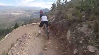
SaveCliffhanger - one of the toughest mountain-biking trails in the world starts right here on our farm and snakes its way up and along the Hawequa mountain, through pristine fynbos, forests and breathtaking natural beauty. We host regular events and mountain-biking enthusiasts come from far and wide to tackle this awe-inspiring trail.
The farm as we know it today became the property of Jacobus Pienaar in 1781 and he named it Kanettefontein because of the abundance of reeds (‘kanette’) on the land.
Vines were planted on the rocky slopes of the Hawequa mountain and wine was made for personal use, but fruit farming was the main focus of the farm. That changed in 1815 when the legendary Anna Lategan, adopter of orphaned slave children, took over.
While they still cultivated fruit, they planted vineyards and Canetsfontein started making wine in earnest
source: Canetsfontein
 google parking directions
 Disclaimer:
Reservations are essential. See link for online reservation below.
Links
Activities Click to view
- Mountain Bike
22 trails
- E-Bike
22 trails
- Hike
28 trails
- Trail Running
28 trails
Region Details
- 12
- 4
- 5
- 1
Region Status
Open as of Dec 29, 2023Stats
- Avg Trail Rating
- Trails (view details)
- 22
- Trails Mountain Bike
- 22
- Trails E-Bike
- 22
- Trails Hike
- 28
- Trails Trail Running
- 28
- Total Distance
- 21 miles
- Total Descent Distance
- 10 miles
- Total Descent
- 6,630 ft
- Total Vertical
- 2,704 ft
- Highest Trailhead
- 3,454 ft
- Reports
- 22
- Photos
- 12
- Ridden Counter
- 2,374
Popular Canetsfontein Mountain Biking Trails
• 100 ★ 5.0 • 3,323 ft • 208 ft • 198 •
Cantesfontein Single Track, joining to an Access Road from the R301 to and
• 100 ★ 5.0 • 4,577 ft • 411 ft • 194 •
Popular blue difficulty singletrack. This multi-use trail can be used one direction and has a moderate overall physical rating with a 411 ft blue climb. Trail visibility is always easy to follow. On average it takes 12 minutes to complete this trail.
Photos of Canetsfontein Mountain Bike
Videos of Canetsfontein Mountain Bike

6:20 |
184 |
Dec 28, 2023
3:10 |
237 |
Dec 28, 2023

trail: Cliffhanger
16:15 |
680 |
Dec 28, 2023 , Wellington
Recent Trail Reports
| status | trail | date | condition | info | user |
|---|---|---|---|---|---|
| Route 66 | Dec 28, 2023 @ 1:53pm Dec 28, 2023 | Ideal | WillieJacobsz Trailforks | ||
| Angels Tears | Dec 28, 2023 @ 1:53pm Dec 28, 2023 | Ideal | WillieJacobsz Trailforks | ||
| Aap d'Huez | Dec 28, 2023 @ 1:53pm Dec 28, 2023 | Ideal | WillieJacobsz Trailforks | ||
| Full Monty 2 | Dec 28, 2023 @ 1:53pm Dec 28, 2023 | Ideal | WillieJacobsz Trailforks | ||
| Full Monty 1 | Dec 28, 2023 @ 1:53pm Dec 28, 2023 | Ideal | WillieJacobsz Trailforks | ||
| Down The Line | Dec 28, 2023 @ 1:53pm Dec 28, 2023 | Ideal | WillieJacobsz Trailforks | ||
| DNF | Dec 28, 2023 @ 1:53pm Dec 28, 2023 | Ideal | WillieJacobsz Trailforks | ||
| Canetsfontein Access Road - DNF to the Cliffhanger | Dec 28, 2023 @ 1:53pm Dec 28, 2023 | Ideal | WillieJacobsz Trailforks | ||
| Canetsfontein Access Road - Angels Tears to DNF | Dec 28, 2023 @ 1:53pm Dec 28, 2023 | Ideal | WillieJacobsz Trailforks | ||
| Canetsfontein Access Road 010 | Dec 28, 2023 @ 1:53pm Dec 28, 2023 | Ideal | WillieJacobsz Trailforks |
Activity Feed
| username | action | type | title | date |
|---|---|---|---|---|
| vpPiGy | wishlist | trail | activity #91471886 | Mar 28, 2026 @ 2:29pm Mar 28, 2026 |
| Nicky-Lombard | wishlist | trail | activity #90741606 | Mar 17, 2026 @ 8:13am Mar 17, 2026 |
| Nicky-Lombard | wishlist | trail | activity #90710171 | Mar 16, 2026 @ 2:52pm Mar 16, 2026 |
| jorgepic79 | ridden | trail | activity #89399418 | Feb 22, 2026 @ 10:04pm Feb 22, 2026 |
| dustrider1 | wishlist | trail | activity #76587842 | Jul 24, 2025 @ 3:57am Jul 24, 2025 |
Recent Comments
| username | type | title | comment | date |
|---|---|---|---|---|
| trail | Cliffhanger - the best trail in the Western Cape! | Dec 28, 2023 @ 1:24pm Dec 28, 2023 |
Nearby Areas
| name | distance | ||||
|---|---|---|---|---|---|
| Welvanpas | 6 | 11 | 1.2 km | ||
| Hawequa | 5 | 3.7 km | |||
| Slanghoek Cellars Mountain Biking Trails | 6 | 7 | 1 | 8.9 km | |
| Paarl Trails - Rhebokskloof | 51 | 41 | 3 | 9.1 km | |
| Paarl Trails - Laborie | 10.9 km |
Activity Type Stats
| activitytype | trails | distance | descent | descent distance | total vertical | rating | global rank | state rank | photos | reports | routes | ridelogs |
|---|---|---|---|---|---|---|---|---|---|---|---|---|
| Mountain Bike | 22 | 21 miles | 6,631 ft | 10 miles | 2,703 ft | #3,154 | #65 | 12 | 22 | 328 | ||
| E-Bike | 22 | 21 miles | 6,631 ft | 10 miles | 2,703 ft | #4,177 | #170 | 22 | 30 | |||
| Hike | 28 | 21 miles | 6,631 ft | 10 miles | 2,703 ft | #6,417 | #163 | 22 | 23 | |||
| Trail Running | 28 | 21 miles | 6,631 ft | 10 miles | 2,703 ft | #5,975 | #166 | 22 | 8 |
Frequently Asked Questions About Canetsfontein
▼
What are the highest rated mountain biking trails in Canetsfontein?
The highest rated mountain biking trails in Canetsfontein are:
- Cliffhanger (4.3/5)
- Aap d'Huez (4.2/5)
- Canetsfontein Access Road 001 (4.2/5)
- Down The Line (4.2/5)
- Full Monty 2 (4.2/5)
▼
Where can I park to ride in Canetsfontein?
There are 1 parking locations listed in Canetsfontein. The most popular parking spots are:
▼
What is the longest trail in Canetsfontein?
The longest trail in Canetsfontein is Cliffhanger at 6.2 km. View all trails sorted by distance.
▼
What are the best & highest rated hiking trails in Canetsfontein?
The best hiking trails in Canetsfontein are: View all hiking trails sorted by popularity score.
Activities
- By WillieJacobsz
 Trailforks SBP SWW & contributors
 - Admins: apply
- #62318 - 1,883 views
- canetsfontein activity log | embed map of Canetsfontein mountain bike trails | canetsfontein mountain biking points of interest
Downloading of trail gps tracks in kml & gpx formats is enabled for Canetsfontein.
You must login to download files.