close
-
Layers w
- Weather Layers
- Pro
- Pro
- Pro
- Pro
- Pro
- Pro
- More Layers
- Pro
- Pro
- Pro
- Pro
-
Upgrade to

3D
Trail Conditions
- Unknown
- Snow Groomed
- Snow Packed
- Snow Covered
- Snow Cover Partial
- Freeze/thaw Cycle
- Icy
- Prevalent Mud
- Wet
- Variable
- Ideal
- Dry
- Very Dry
Trail Flow (Ridden Direction)
Trailforks scans users ridelogs to determine the most popular direction each trail is ridden. A good flowing trail network will have most trails flowing in a single direction according to their intension.
The colour categories are based on what percentage of riders are riding a trail in its intended direction.
The colour categories are based on what percentage of riders are riding a trail in its intended direction.
- > 96%
- > 90%
- > 80%
- > 70%
- > 50%
- < 50%
- bi-directional trail
- no data
Trail Last Ridden
Trailforks scans ridelogs to determine the last time a trail was ridden.
- < 2 days
- < 1 week
- < 2 weeks
- < 1 month
- < 6 months
- > 6 months
Trail Ridden Direction
The intended direction a trail should be ridden.
- Downhill Only
- Downhill Primary
- Both Directions
- Uphill Primary
- Uphill Only
- One Direction
Contribute Details
Colors indicate trail is missing specified detail.
- Description
- Photos
- Description & Photos
- Videos
Trail Popularity ?
Trailforks scans ridelogs to determine which trails are ridden the most in the last 9 months.
Trails are compared with nearby trails in the same city region with a possible 25 colour shades.
Think of this as a heatmap, more rides = more kinetic energy = warmer colors.
- most popular
- popular
- less popular
- not popular
ATV/ORV/OHV Filter
Max Vehicle Width
inches
US Cell Coverage
Legend

Radar Time
Activity Recordings
Trailforks uses anonymized public activity data.
?
Activity Recordings
Trailforks uses anonymized public activity data.
?
Personal Heatmap
▶
Activity Types
all
/
none
▶
Options
2
Date range
month
–
Winter Trails
Warning
A routing network for winter maps does not exist. Selecting trails using the winter trails layer has been disabled.
Missing Trails
Most Popular
Least Popular
Trails are colored based on popularity. The more popular a trail is, the more red. Less popular trails trend towards green.
Jump Magnitude Heatmap
Heatmap of where riders jump on trails. Zoom in to see individual jumps, click circles to view jump details.
BC Backroad Status
![map legend]()
Service Road Atlas is a free to use, community-driven service for viewing and creating reports on the numerous back-country service roads around B.C. and Alberta.

Slope Aspect
Direction the slope faces
Trails Deemphasized
Trails are shown in grey.
Only show trails with no bike usage.
Suggested Layers
Based on selected activity type
Save the current map location and zoom level as your default home location whenever this page is loaded.
SavePopular Trail Networks
view all areas »
No description for Cape Breton Island has been added yet!
Login or register to submit one.
Region Details
- 53
- 21
- 50
- 29
Local Trail Association
Stats
- Avg Trail Rating
- Trails (view details)
- 259
- Trails Mountain Bike
- 153
- Trails E-Bike
- 58
- Trails Gravel Bike
- 1
- Trails Horse
- 37
- Trails Hike
- 228
- Trails Trail Running
- 220
- Trails Dirtbike/Moto
- 35
- Trails ATV/ORV/OHV
- 48
- Trails Snowmobile
- 39
- Trails Snowshoe
- 153
- Trails Downhill Ski
- 29
- Trails Backcountry Ski
- 1
- Trails Nordic Ski
- 77
- Total Distance
- 404 miles
- Total Descent
- 30,208 ft
- Total Vertical
- 1,403 ft
- Highest Trailhead
- 1,404 ft
- Reports
- 148
- Photos
- 84
- Ridden Counter
- 4,490
Articles
The 10 Most Beautiful National Parks in Canada
Jun 17, 2024 from outsideonline.com
Spectacular mountains and deep fjords, powder-blue lakes and sea stacks: here’s your bucket list of national parks to visit up north
Sub Regions
- County of Inverness (0)
- Pleasant Bay (0)
- Pleasant Bay (0)
- Victoria County (19)
- Ingonish (19)
- North River Bridge (0)
- Baddeck (0)
- Cape North (2)
- Cheticamp (1)
- Glace Bay (11)
- Cadegan Brook (7)
- Inverness (1)
- Judique (1)
- Mabou (6)
- New Waterford (3)
- North Sydney (4)
- Port Hawkesbury (18)
- St Peter's (17)
- Sydney (54)
- Sydney River (22)
- Carmichael Trails (16)
- Glen Morrison (4)
- Joe's Lake (6)
Popular Cape Breton Island Mountain Biking Trails
• ★ 0.0 • 1 mile • 49 ft • 156 •
This is a pathway from Barangaroo park which follows the water all the way down to the pyrmont bridge. A few bits are still in construction
• 100 ★ 4.0 • 3 miles • 446 ft • 33 •
This level trail follows the bottom of the Chéticamp River canyon with cliffs almost 400 metres (1,300 ft) high towering above. The First Pool is about 3.6 km up the Chéticamp River. The trail narrows and continues to Chance Pool...
• 70 ★ 2.7 • 3,366 ft • 14 ft • 23 •
Popular green difficulty singletrack. This mountain bike primary trail can be used both directions and has a moderate overall physical rating with a 14 ft green climb. It features bridge. On average it takes 9 minutes to complete this trail.
• 50 ★ 2.5 • 2,225 ft • 24 ft • 22 •
Moderately popular blue difficulty singletrack. This mountain bike primary trail can be used both directions. On average it takes 5 minutes to complete this trail.
• 55 ★ 5.0 • 3 miles • 229 ft • 20 •
Marvel at the spectacular stands of hardwood trees, boulders bigger than cars, old abandoned beaver ponds, meadows, apple trees and even the remains of an old gold mine. This trail follows the river for most of the way, but you can...
• 100 ★ 0.0 • 13 miles • 151 ft • 19 •
The Ceilidh Coastal Trail begins at the entrance to Cape Breton Island, at the Trans Canada Trail Pavilion and Trailhead Kiosk beside the Canso Canal. This section continues for 22kms to Chisholm’s Brook, Long Point. Cyclists are...
• 85 ★ 3.0 • 1,096 ft • 22 ft • 19 •
Popular blue difficulty singletrack. This mountain bike primary trail can be used both directions. On average it takes 2 minutes to complete this trail.
• 100 ★ 0.0 • 11 miles • 111 ft • 19 •
The Judique Flyer Trail section begins at the Chisholm River Trestle in Long Point. The trail continues 19kms to Little Judique Harbour. Several access points and trailheads along route with parking lots, interpretive panels and amenities.
Photos of Cape Breton Island Mountain Bike
Videos of Cape Breton Island Mountain Bike
trail: John Doe
0:14 |
40 |
Oct 3, 2020
trail: John Doe
0:16 |
35 |
Oct 3, 2020
trail: John Doe
0:24 |
39 |
Oct 3, 2020
trail: ATV Trail
3:56 |
168 |
May 23, 2012
trail: ATV Trail
4:08 |
98 |
May 23, 2012
trail: Fast Down
78 |
Oct 20, 2024 , Sydney River
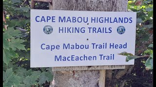
trail: MacEachen Trail
29:15 |
84 |
Sep 4, 2024 , Mabou
trail: Snake Bite
2:29 |
68 |
Sep 4, 2024 , Sydney River
Recent Trail Reports
| status | trail | date | condition | info | user |
|---|---|---|---|---|---|
| Barangaroo Wulugul Walk Pathway Sydney Basin | Jan 17, 2026 @ 3:42am (Australia/Sydney) Jan 16, 2026 | Ideal | RomanMark | ||
| Salmon Pools Cape Breton Highlands National Park | Aug 27, 2024 @ 2:39pm Aug 27, 2024 | Ideal | greg13 KEPPOCH | ||
| Down To Lower Carmichael Trails | May 31, 2024 @ 3:19pm May 31, 2024 | Ideal | teabee4 | ||
| Snake Bite Carmichael Trails | May 4, 2024 @ 5:27pm May 4, 2024 | Ideal | teabee4 | ||
| First or Last Hill Carmichael Trails | May 4, 2024 @ 1:42am May 4, 2024 | Ideal | teabee4 | ||
| Billy's Lung Carmichael Trails | May 4, 2024 @ 1:42am May 4, 2024 | Ideal | teabee4 | ||
| Lean Too Carmichael Trails | May 4, 2024 @ 1:42am May 4, 2024 | Ideal | teabee4 | ||
| Ride The Flow Carmichael Trails | May 4, 2024 @ 1:42am May 4, 2024 | Ideal | teabee4 | ||
| Fast Down Carmichael Trails | May 4, 2024 @ 1:42am May 4, 2024 | Unknown | teabee4 | ||
| Rolling Up Carmichael Trails | May 4, 2024 @ 1:42am May 4, 2024 | Variable | teabee4 |
Activity Feed
| username | action | type | title | date |
|---|---|---|---|---|
| DanRobin | ridden | trail | activity #96161406 | Jun 3, 2026 @ 9:30am Jun 3, 2026 |
| PSx8TR | wishlist | region | activity #95275202 | May 22, 2026 @ 4:16pm May 22, 2026 |
| RobLQ8ECt | wishlist | region | activity #95031831 | May 19, 2026 @ 4:39am May 19, 2026 |
| ampmtb | wishlist | region | activity #93126103 | Apr 21, 2026 @ 7:56pm Apr 21, 2026 |
| Clynds002 | wishlist | trail | activity #87726965 | Jan 24, 2026 @ 7:28am Jan 24, 2026 |
Recent Comments
| username | type | title | comment | date |
|---|---|---|---|---|
| trail | Start at the Cap Rouge camping area and it... | Aug 4, 2025 @ 4:00pm Aug 4, 2025 | ||
| trail | Agree with earlier comments that this is not a... | Aug 17, 2024 @ 10:54am Aug 17, 2024 | ||
| trail | Easy hike along the river. Water accessible... | Sep 28, 2023 @ 2:18pm Sep 28, 2023 | ||
| trail | Great hike to get your blood pumping. We did... | Sep 28, 2023 @ 5:54am Sep 28, 2023 | ||
| trail | Trailforks is a user contributed map, you are... | Aug 9, 2023 @ 4:16pm Aug 9, 2023 |
Local Badges
-

Descent 100k Badge0 awarded -

Mountain Biking 100k Badge0 awarded -

Epic Ride Descent 2k21 awarded -

Descent 10k Badge0 awarded -

Big Ride 30k23 awarded -
Big Ride 30k2 awarded
Bike & Skill Parks
| name | type | city | rating |
|---|---|---|---|
| Port Hawkesbury Pump Track | skill park | Port Hawkesbury | |
| Craigmore Creek ORM Park | skill park | Port Hawkesbury | |
| Open Hearth Park Bike Park | skill park | Sydney | |
| Glace Bay Skate Park | skill park | Glace Bay | |
| Neville Park Pumptrack | skill park | Sydney |
Activity Type Stats
| activitytype | trails | distance | descent | descent distance | total vertical | rating | global rank | state rank | photos | reports | routes | ridelogs |
|---|---|---|---|---|---|---|---|---|---|---|---|---|
| Mountain Bike | 153 | 302 miles | 13,799 ft | 125 miles | 1,194 ft | 72 | 139 | 3,523 | ||||
| E-Bike | 58 | 228 miles | 9,465 ft | 98 miles | 1,115 ft | 105 | 66 | |||||
| Gravel Bike | 1 | 1 | 28 | |||||||||
| Horse | 37 | 182 miles | 8,478 ft | 79 miles | 1,115 ft | 42 | ||||||
| Hike | 228 | 371 miles | 21,972 ft | 149 miles | 1,404 ft | 10 | 145 | 2,605 | ||||
| Trail Running | 220 | 364 miles | 21,585 ft | 147 miles | 1,404 ft | 142 | 197 | |||||
| Dirtbike/Moto | 35 | 99 miles | 4,213 ft | 41 miles | 538 ft | 42 | 10 | |||||
| ATV/ORV/OHV | 48 | 229 miles | 9,495 ft | 98 miles | 1,115 ft | 45 | 36 | |||||
| Snowmobile | 39 | 196 miles | 8,333 ft | 84 miles | 1,115 ft | 42 | ||||||
| Snowshoe | 153 | 291 miles | 15,469 ft | 119 miles | 1,342 ft | 53 | 30 | |||||
| Downhill Ski | 29 | 16 miles | 5,623 ft | 7 miles | 866 ft | 3 | 295 | |||||
| Backcountry Ski | 1 | 1,388 ft | 30 ft | 906 ft | 30 ft | 3 | 13 | |||||
| Nordic Ski | 77 | 241 miles | 11,247 ft | 102 miles | 1,115 ft | 48 | 122 |
Activities
- Cape Breton Island Mountain Biking Trails
- Cape Breton Island E-Biking Trails
- Cape Breton Island Horseback Trails
- Cape Breton Island Hiking Trails
- Cape Breton Island Trail Running Trails
- Cape Breton Island Dirtbiking Trails
- Cape Breton Island ATVing/Offroading Trails
- Cape Breton Island Snowmobiling Trails
- Cape Breton Island Snowshoeing Trails
- Cape Breton Island Skiing Trails
- Cape Breton Island Nordic Skiing Trails
Trails
Points of Interest
- By JeffV
 & contributors
 - Admins: bent6543
- #6202 - 18,377 views
- cape breton island activity log | embed map of Cape Breton Island mountain bike trails | cape breton island mountain biking points of interest
Downloading of trail gps tracks in kml & gpx formats is enabled for Cape Breton Island.
You must login to download files.