close
-
Layers w
- Weather Layers
- Pro
- Pro
- Pro
- Pro
- Pro
- Pro
- More Layers
- Pro
- Pro
- Pro
- Pro
-
Upgrade to

3D
Trail Conditions
- Unknown
- Snow Groomed
- Snow Packed
- Snow Covered
- Snow Cover Partial
- Freeze/thaw Cycle
- Icy
- Prevalent Mud
- Wet
- Variable
- Ideal
- Dry
- Very Dry
Trail Flow (Ridden Direction)
Trailforks scans users ridelogs to determine the most popular direction each trail is ridden. A good flowing trail network will have most trails flowing in a single direction according to their intension.
The colour categories are based on what percentage of riders are riding a trail in its intended direction.
The colour categories are based on what percentage of riders are riding a trail in its intended direction.
- > 96%
- > 90%
- > 80%
- > 70%
- > 50%
- < 50%
- bi-directional trail
- no data
Trail Last Ridden
Trailforks scans ridelogs to determine the last time a trail was ridden.
- < 2 days
- < 1 week
- < 2 weeks
- < 1 month
- < 6 months
- > 6 months
Trail Ridden Direction
The intended direction a trail should be ridden.
- Downhill Only
- Downhill Primary
- Both Directions
- Uphill Primary
- Uphill Only
- One Direction
Contribute Details
Colors indicate trail is missing specified detail.
- Description
- Photos
- Description & Photos
- Videos
Trail Popularity ?
Trailforks scans ridelogs to determine which trails are ridden the most in the last 9 months.
Trails are compared with nearby trails in the same city region with a possible 25 colour shades.
Think of this as a heatmap, more rides = more kinetic energy = warmer colors.
- most popular
- popular
- less popular
- not popular
ATV/ORV/OHV Filter
Max Vehicle Width
inches
US Cell Coverage
Legend

Radar Time
Activity Recordings
Trailforks uses anonymized public activity data.
?
Activity Recordings
Trailforks uses anonymized public activity data.
?
Personal Heatmap
▶
Activity Types
all
/
none
▶
Options
2
Date range
month
–
Winter Trails
Warning
A routing network for winter maps does not exist. Selecting trails using the winter trails layer has been disabled.
Missing Trails
Most Popular
Least Popular
Trails are colored based on popularity. The more popular a trail is, the more red. Less popular trails trend towards green.
Jump Magnitude Heatmap
Heatmap of where riders jump on trails. Zoom in to see individual jumps, click circles to view jump details.
BC Backroad Status
![map legend]()
Service Road Atlas is a free to use, community-driven service for viewing and creating reports on the numerous back-country service roads around B.C. and Alberta.

Slope Aspect
Direction the slope faces
Trails Deemphasized
Trails are shown in grey.
Only show trails with no bike usage.
Suggested Layers
Based on selected activity type
Save the current map location and zoom level as your default home location whenever this page is loaded.
Save
No description for Cape Verde has been added yet!
Login or register to submit one.
Region Details
- 1
- 9
- 3
- 1
Stats
- Avg Trail Rating
- Global Ranking
- #106
- Trails (view details)
- 14
- Trails Mountain Bike
- 16
- Trails E-Bike
- 15
- Trails Hike
- 16
- Trails Trail Running
- 16
- Total Distance
- 5 miles
- Total Descent Distance
- 3 miles
- Total Descent
- 736 ft
- Total Vertical
- 710 ft
- Highest Trailhead
- 723 ft
- Reports
- 7
- Photos
- 3
- Ridden Counter
- 33
Articles
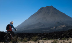
Video: Richard Gasperotti Takes an eMTB to the Top of a Volcano in ‘Pico do Fogo’
Nov 29, 2025 from pinkbike.com
2,829 metres of lava rock, brutal hike-a-bikes, and one massive descent from crater to sea level.
Sub Regions
Popular Cape Verde Mountain Biking Trails
• 85 ★ 0.0 • 3 miles • 107 ft • 4 •
Perhaps the most flowy single trail in the region. Wonderful views over the mountains of the Serra Malagueta.
• 100 ★ 0.0 • 3 miles • 197 ft • 3 •
The classic on Cape Verde. This top single trail is often blocked and not easy... It leads through the almost jungle-like landscape down to Principal, especially after the rainy season. Unique scenery - your trail adventure on Santiago.
• 95 ★ 0.0 • 4 miles • 992 ft • 2 •
Very adventurous single trail down to Achada Lagoa and then over the Passo De Gato to Mato Brazil. Often quite overgrown and slippery in the rainy season...
• ★ 0.0 • 3 miles • 48 ft • 2 •
The beach route between Guereo and Rasta Paradise. Can be ridden at low tide only. Low pressure, tubeless tyres required.
• ★ 0.0 • 3 miles • 286 ft • 2 •
A trail following the pylon line. The route can be indistinct after wet season (Aug - Sept) due to vegetation, but becomes clearer from November. Navigate with a bar mounted navigation device. Not for beginners.
• 5 ★ 0.0 • 3 miles • 7 ft • 2 •
Great and pretty difficult single trail in scenic landscape down into the valley of the Barca river. The 2nd part in the river valley is then technically very easy.
• ★ 0.0 • 5 miles • 106 ft • 2 •
North side of the mangrove, linking with the Southern trail. Sandy in places. The route adjacent to the mangrove can become muddy after rain.
• 5 ★ 5.0 • 3 miles • 53 ft • 2 •
Beautiful partly also technical single trail. After the rainy season rideable from about mid Nov. Built, improved and maintained by ThePlace Cabo Verde and King Fisher Village, Tarrafal.
Recent Comments
| username | type | title | comment | date |
|---|---|---|---|---|
| trail | Perfect for the first day ride! | Nov 3, 2023 @ 12:07pm Nov 3, 2023 | ||
| trail | go for the flow | Nov 3, 2023 @ 11:55am Nov 3, 2023 | ||
| trail | There has been recent earthworks close to this... | Dec 11, 2022 @ 11:49pm Dec 11, 2022 |
Activity Type Stats
| activitytype | trails | distance | descent | descent distance | total vertical | rating | global rank | state rank | photos | reports | routes | ridelogs |
|---|---|---|---|---|---|---|---|---|---|---|---|---|
| Mountain Bike | 16 | 5 miles | 735 ft | 3 miles | 709 ft | #106 | 3 | 7 | 199 | |||
| E-Bike | 15 | 5 miles | 735 ft | 3 miles | 709 ft | #102 | 7 | 34 | ||||
| Hike | 16 | 5 miles | 735 ft | 3 miles | 709 ft | #121 | 7 | 213 | ||||
| Trail Running | 16 | 5 miles | 735 ft | 3 miles | 709 ft | #119 | 7 | 9 |
Activities
Trails
Points of Interest
- By b-rat
 WMBC Admin & contributors
 - Admins: apply
- #37257 - 3,007 views
- cape verde activity log | embed map of Cape Verde mountain bike trails |
Downloading of trail gps tracks in kml & gpx formats is enabled for Cape Verde.
You must login to download files.