close
-
Layers w
- Weather Layers
- Pro
- Pro
- Pro
- Pro
- Pro
- Pro
- More Layers
- Pro
- Pro
- Pro
- Pro
-
Upgrade to

3D
Trail Conditions
- Unknown
- Snow Groomed
- Snow Packed
- Snow Covered
- Snow Cover Partial
- Freeze/thaw Cycle
- Icy
- Prevalent Mud
- Wet
- Variable
- Ideal
- Dry
- Very Dry
Trail Flow (Ridden Direction)
Trailforks scans users ridelogs to determine the most popular direction each trail is ridden. A good flowing trail network will have most trails flowing in a single direction according to their intension.
The colour categories are based on what percentage of riders are riding a trail in its intended direction.
The colour categories are based on what percentage of riders are riding a trail in its intended direction.
- > 96%
- > 90%
- > 80%
- > 70%
- > 50%
- < 50%
- bi-directional trail
- no data
Trail Last Ridden
Trailforks scans ridelogs to determine the last time a trail was ridden.
- < 2 days
- < 1 week
- < 2 weeks
- < 1 month
- < 6 months
- > 6 months
Trail Ridden Direction
The intended direction a trail should be ridden.
- Downhill Only
- Downhill Primary
- Both Directions
- Uphill Primary
- Uphill Only
- One Direction
Contribute Details
Colors indicate trail is missing specified detail.
- Description
- Photos
- Description & Photos
- Videos
Trail Popularity ?
Trailforks scans ridelogs to determine which trails are ridden the most in the last 9 months.
Trails are compared with nearby trails in the same city region with a possible 25 colour shades.
Think of this as a heatmap, more rides = more kinetic energy = warmer colors.
- most popular
- popular
- less popular
- not popular
ATV/ORV/OHV Filter
Max Vehicle Width
inches
US Cell Coverage
Legend

Radar Time
Activity Recordings
Trailforks uses anonymized public activity data.
?
Activity Recordings
Trailforks uses anonymized public activity data.
?
Personal Heatmap
▶
Activity Types
all
/
none
▶
Options
2
Date range
month
–
Winter Trails
Warning
A routing network for winter maps does not exist. Selecting trails using the winter trails layer has been disabled.
Missing Trails
Most Popular
Least Popular
Trails are colored based on popularity. The more popular a trail is, the more red. Less popular trails trend towards green.
Jump Magnitude Heatmap
Heatmap of where riders jump on trails. Zoom in to see individual jumps, click circles to view jump details.
BC Backroad Status
![map legend]()
Service Road Atlas is a free to use, community-driven service for viewing and creating reports on the numerous back-country service roads around B.C. and Alberta.

Slope Aspect
Direction the slope faces
Trails Deemphasized
Trails are shown in grey.
Only show trails with no bike usage.
Suggested Layers
Based on selected activity type
Save the current map location and zoom level as your default home location whenever this page is loaded.
Save
No description for Carrara has been added yet!
Login or register to submit one.
This region uses the Uk/Euro style trail grading system.
Activities Click to view
- Mountain Bike
27 trails
- E-Bike
21 trails
- Adaptive Bike
0 trails
- Winter Fat Bike
0 trails
- Horse
3 trails
- Hike
25 trails
- Trail Running
25 trails
- Dirtbike/Moto
2 trails
- ATV/ORV/OHV
2 trails
Region Details
- 3
- 6
- 7
- 3
- 1
- 5
Region Status
Caution as of Jun 4, 2026Stats
- Avg Trail Rating
- Trails (view details)
- 27
- Trails Mountain Bike
- 27
- Trails E-Bike
- 21
- Trails Horse
- 3
- Trails Hike
- 25
- Trails Trail Running
- 25
- Trails Dirtbike/Moto
- 2
- Trails ATV/ORV/OHV
- 2
- Total Distance
- 27 miles
- Total Descent
- 17,571 ft
- Total Vertical
- 4,328 ft
- Highest Trailhead
- 4,436 ft
- Reports
- 469
- Photos
- 38
- Ridden Counter
- 1,241
Sub Regions
-
Campocecina
- 1
- 2
- 1
Popular Carrara Mountain Biking Trails
• 90 ★ 4.5 • 1 mile • 18 ft • 74 •
Highly rated popular blue difficulty family friendly singletrack. This mountain bike primary trail can be used downhill only and has a hard overall physical rating with a 18 ft blue climb. Trail visibility is always easy to follow. On average it takes 17 minutes to complete this trail.
• 65 ★ 4.4 • 2 miles • 227 ft • 65 •
Moderately popular red difficulty singletrack. This multi-use trail can be used downhill only and has a hard overall physical rating with a 227 ft blue climb. It features rock face and rock garden. On average it takes 35 minutes to complete this trail.
• 70 ★ 3.2 • 1 mile • 0 ft • 62 •
Sentiero di collegamento tra Castelpoggio e Casano di Ortonovo
• 60 ★ 3.8 • 1 mile • 31 ft • 61 •
Moderately popular red difficulty singletrack. This multi-use trail can be used downhill primary and has a moderate overall physical rating with a 31 ft blue climb. It features rock face and rock garden. On average it takes 15 minutes to complete this trail.
• 50 ★ 5.0 • 3,163 ft • 91 ft • 39 •
Moderately popular blue difficulty singletrack. This mountain bike primary trail can be used downhill primary and has a moderate overall physical rating with a 91 ft blue climb. It features rock face and rock garden. Trail visibility is always easy to follow. On average it takes 4 minutes to complete this trail.
• 50 ★ 4.5 • 4,280 ft • 18 ft • 36 •
Moderately popular blue difficulty singletrack. This mountain bike primary trail can be used downhill primary and has a moderate overall physical rating with a 18 ft blue climb. It features berm, drop, jump and rock garden. Trail visibility is always easy to follow. On average it takes 9 minutes to complete this trail.
Carrara Mountain Bike Routes
9 miles • 2,263 ft • 10 • Loop •
Salita da asfalto fino al bivio "da Flo", poi gli ultimi km sterrati. Alcuni sentieri su proprietà...
31 miles • 5,268 ft • 3 • Loop •
Official route of "Vita all'aria aperta 2020"
10 miles • 2,136 ft • 0 • Loop •
anello da carrara, via del soldato, sorgnano, gragnana e arrivo a carrara
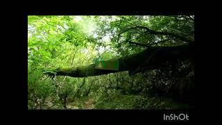
Photos of Carrara Mountain Bike
Videos of Carrara Mountain Bike
7:36 |
10 |
Jun 2, 2026 , Carrara
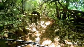
trail: Il Tulio
7:03 |
1 |
Jun 2, 2026 , Carrara
11:44 |
68 |
Apr 7, 2026 , Carrara
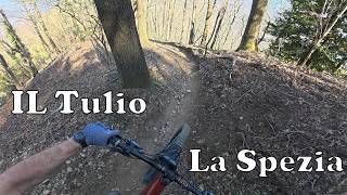
trail: Il Tulio
11:25 |
55 |
Apr 7, 2026 , Carrara
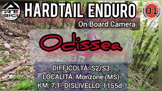
trail: Odissea
33:16 |
88 |
Jul 1, 2025 , Carrara
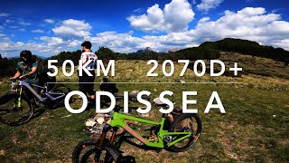
trail: Odissea
23:56 |
157 |
May 16, 2024 , Carrara
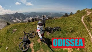
trail: Odissea
30:08 |
251 |
May 15, 2024 , Carrara
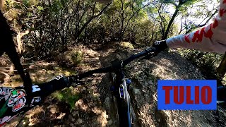
trail: Il Tulio
6:37 |
136 |
Feb 4, 2024 , Carrara
Current Trail Warnings
| status | trail | date | condition | user | info |
|---|---|---|---|---|---|
| Orecchie | May 22, 2026 @ 10:18am (Europe/Rome) May 22, 2026 | Unknown | endsenzfret | Fattibile solo la prima parte |
Recent Trail Reports
| status | trail | date | condition | info | user |
|---|---|---|---|---|---|
| Scacciapensieri | Jun 4, 2026 @ 10:00am (Europe/Rome) Jun 4, 2026 | Ideal | alexmetaam | ||
| Il Tulio | May 3, 2026 @ 3:05pm (Europe/Rome) May 3, 2026 | Dry | Ale-B-IT | ||
| L'Annunziata | May 3, 2026 @ 9:51am (Europe/Rome) May 3, 2026 | Dry | Ale-B-IT | ||
| Bastardo | Apr 19, 2026 @ 4:01pm (Europe/Rome) Apr 19, 2026 | Ideal | Mattiaangelini92 | ||
| Tenerano trail | Apr 18, 2026 @ 9:10pm (Europe/Rome) Apr 18, 2026 | Very Dry | Albe79 | ||
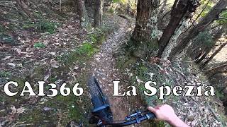
| CAI366 - Barattini/Volpiglione | Mar 17, 2026 @ 8:06am (Europe/Rome) Mar 17, 2026 | Ideal | alexDmtbBOqvH8 | ||
| Fadiga connection | Feb 28, 2026 @ 1:13pm (Europe/San_Marino) Feb 28, 2026 | Variable | santavecchio | ||
| Palazzetti | Dec 21, 2025 @ 7:10pm (Europe/Rome) Dec 21, 2025 | Unknown | Andrea3e4CPJ | ||
| Odissea | Nov 29, 2025 @ 9:03am (Europe/San_Marino) Nov 29, 2025 | Wet | Metato | ||
| Pedofilo | Oct 18, 2025 @ 12:34am (Pacific/Midway) Oct 18, 2025 | Ideal | Orso |
Activity Feed
| username | action | type | title | date |
|---|---|---|---|---|
| Pallacce91 | difficultyvote | trail | activity #97026820 | Jun 15, 2026 @ 12:41am Jun 15, 2026 |
| Moritzhalb | wishlist | trail | activity #96735009 | Jun 11, 2026 @ 7:07am Jun 11, 2026 |
| alexmetaam | add | report | activity #96224991 | Jun 4, 2026 @ 7:12am Jun 4, 2026 |
| raffganz | comment | trail | activity #96073838 | Jun 2, 2026 @ 4:22am Jun 2, 2026 |
| raffganz | add | video | activity #96073730 | Jun 2, 2026 @ 4:20am Jun 2, 2026 |
Recent Comments
| username | type | title | comment | date |
|---|---|---|---|---|
| trail | Trail molto divertente con passaggi stretti e... | Jun 2, 2026 @ 4:22am Jun 2, 2026 | ||
| trail | Concordo con il commento precedente, secondo... | Jan 1, 2026 @ 7:07am Jan 1, 2026 | ||
| trail | Semplicemente fantastico! Livello tecnico... | May 18, 2025 @ 2:22pm May 18, 2025 | ||
| trail | Fatto oggi la seconda parte da quota 1000 Mt,... | May 10, 2025 @ 7:45am May 10, 2025 | ||
| trail | Trail divertente, a tratti con passaggi... | Apr 27, 2025 @ 12:04am Apr 27, 2025 |
Local Badges
-

Epic Ride Climb 2k159 awarded -

Climbing 10k Badge33 awarded -

Climbing 100k Badge1 awarded -

Epic Ride Descent 2k159 awarded -

Descent 10k Badge34 awarded -

Descent 100k Badge2 awarded
Activity Type Stats
| activitytype | trails | distance | descent | descent distance | total vertical | rating | global rank | state rank | photos | reports | routes | ridelogs |
|---|---|---|---|---|---|---|---|---|---|---|---|---|
| Mountain Bike | 27 | 27 miles | 17,572 ft | 18 miles | 4,327 ft | #3,454 | #187 | 38 | 465 | 2 | 2,785 | |
| E-Bike | 21 | 22 miles | 15,194 ft | 15 miles | 4,327 ft | #3,632 | #342 | 447 | 1 | 1,010 | ||
| Horse | 3 | 2 miles | 928 ft | 1 mile | 1,555 ft | #1,640 | #73 | 54 | 3 | |||
| Hike | 25 | 23 miles | 13,783 ft | 14 miles | 4,009 ft | #6,255 | #313 | 461 | 172 | |||
| Trail Running | 25 | 23 miles | 13,783 ft | 14 miles | 4,009 ft | #5,730 | #301 | 461 | 40 | |||
| Dirtbike/Moto | 2 | 3,445 ft | 607 ft | 1,978 ft | 515 ft | #837 | #31 | 53 | ||||
| ATV/ORV/OHV | 2 | 3,445 ft | 607 ft | 1,978 ft | 515 ft | #581 | #13 | 53 |
Frequently Asked Questions About Carrara
▼
What are the best places to ride in Carrara?
Carrara has 1 areas to explore for mountain biking. The top rated areas are:
▼
What are the highest rated mountain biking trails in Carrara?
The highest rated mountain biking trails in Carrara are:
- Odissea (4.3/5)
- CAI366 - Barattini/Volpiglione (4.3/5)
- Sentiero dei Colombi (4.2/5)
- L'Annunziata (4.2/5)
- Palazzetti (4.2/5)
▼
What is the best time of the year to ride in Carrara?
Based on ride log data, the most popular months to ride in Carrara are:
- November (11 activities)
- May (5 activities)
- October (5 activities)
▼
Where can I park to ride in Carrara?
There are 3 parking locations listed in Carrara. The most popular parking spots are: View all parking and trailhead locations on the map to plan your visit.
Activities
Trails
Points of Interest
- By Total13
 & contributors
 - Admins: DanielePracchia, WCT
- #19164 - 4,890 views
- carrara activity log | embed map of Carrara mountain bike trails | carrara mountain biking points of interest
Downloading of trail gps tracks in kml & gpx formats is enabled for Carrara.
You must login to download files.