close
-
Layers w
- Weather Layers
- Pro
- Pro
- Pro
- Pro
- Pro
- Pro
- More Layers
- Pro
- Pro
- Pro
- Pro
-
Upgrade to

3D
Trail Conditions
- Unknown
- Snow Groomed
- Snow Packed
- Snow Covered
- Snow Cover Partial
- Freeze/thaw Cycle
- Icy
- Prevalent Mud
- Wet
- Variable
- Ideal
- Dry
- Very Dry
Trail Flow (Ridden Direction)
Trailforks scans users ridelogs to determine the most popular direction each trail is ridden. A good flowing trail network will have most trails flowing in a single direction according to their intension.
The colour categories are based on what percentage of riders are riding a trail in its intended direction.
The colour categories are based on what percentage of riders are riding a trail in its intended direction.
- > 96%
- > 90%
- > 80%
- > 70%
- > 50%
- < 50%
- bi-directional trail
- no data
Trail Last Ridden
Trailforks scans ridelogs to determine the last time a trail was ridden.
- < 2 days
- < 1 week
- < 2 weeks
- < 1 month
- < 6 months
- > 6 months
Trail Ridden Direction
The intended direction a trail should be ridden.
- Downhill Only
- Downhill Primary
- Both Directions
- Uphill Primary
- Uphill Only
- One Direction
Contribute Details
Colors indicate trail is missing specified detail.
- Description
- Photos
- Description & Photos
- Videos
Trail Popularity ?
Trailforks scans ridelogs to determine which trails are ridden the most in the last 9 months.
Trails are compared with nearby trails in the same city region with a possible 25 colour shades.
Think of this as a heatmap, more rides = more kinetic energy = warmer colors.
- most popular
- popular
- less popular
- not popular
ATV/ORV/OHV Filter
Max Vehicle Width
inches
US Cell Coverage
Legend

Radar Time
Activity Recordings
Trailforks uses anonymized public activity data.
?
Activity Recordings
Trailforks uses anonymized public activity data.
?
Personal Heatmap
▶
Activity Types
all
/
none
▶
Options
2
Date range
month
–
Winter Trails
Warning
A routing network for winter maps does not exist. Selecting trails using the winter trails layer has been disabled.
Missing Trails
Most Popular
Least Popular
Trails are colored based on popularity. The more popular a trail is, the more red. Less popular trails trend towards green.
Jump Magnitude Heatmap
Heatmap of where riders jump on trails. Zoom in to see individual jumps, click circles to view jump details.
BC Backroad Status
![map legend]()
Service Road Atlas is a free to use, community-driven service for viewing and creating reports on the numerous back-country service roads around B.C. and Alberta.

Slope Aspect
Direction the slope faces
Trails Deemphasized
Trails are shown in grey.
Only show trails with no bike usage.
Suggested Layers
Based on selected activity type
Save the current map location and zoom level as your default home location whenever this page is loaded.
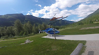
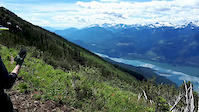
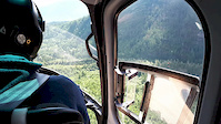
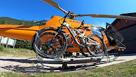
SaveThe Mount Cartier recreation trail has been used for many years as a great early season mountain bike ride. The lower section is one of the first trails to melt out in the spring. More recently, the potential of this trail has begun to show itself…the hardiest of riders are riding/pushing up to the summit of Mount Cartier and the more adventurous are getting a heli-drop to the summit and down-hilling it.The summit views are all time
This trail is managed by the Canadian Enduro Series.
This trail is managed by the Canadian Enduro Series.
source: Revelstoke Cycling Association
Primary Trail Type: All-Mountain & Downhill
eBikes Allowed:
No
 google parking directions
 Access Info:
From Revelstoke drive about 10km south on Airport Way, there is a brown trailhead kiosk on the east side of the road and parking for about 10 cars, please angle park only.
Disclaimer:
*This is a multi-use trail*
This trail is managed by the Canadian Enduro Series, if you'd like to make a donation to the trail please email [email protected]
This trail is managed by the Canadian Enduro Series, if you'd like to make a donation to the trail please email [email protected]
Activities Click to view
- Hike
2 trails
- Mountain Bike
1 trails
- Trail Running
2 trails
Region Details
- 1
Region Status
Caution as of May 3, 2026Stats
- Avg Trail Rating
- Trails (view details)
- 1
- Trails Mountain Bike
- 2
- Trails E-Bike
- 2
- Trails Hike
- 2
- Trails Trail Running
- 2
- Total Distance
- 9 miles
- Total Descent
- 6,767 ft
- Total Vertical
- 6,985 ft
- Highest Trailhead
- 8,517 ft
- Reports
- 197
- Photos
- 448
- Ridden Counter
- 843
Popular Cartier Mountain Biking Trails
• 35 ★ 4.0 • 1 mile • 726 ft • 352 • • hike
Great but challenging early season out and back ride to a lookout (the snow goes early on this side of the valley). Some steep tight switchbacks and punchy climbs. For more of a challenge continue to push/ride your bike to the top of...
• 15 ★ 4.4 • 8 miles • 103 ft • 301 • • hike
Hiking trail to the alpine. Multi-use trail, so please yield to hikers. The top section is rough single track with tight hiker corners. The bottom section is faster, rooty, slightly less technical unless wet. Note: This trail is NOT...
Photos of Cartier Mountain Bike
Videos of Cartier Mountain Bike
trail: Mt. Cartier Upper
11:05 |
44 |
Mar 26, 2021

trail: Mt. Cartier Upper
0:07 |
16 |
Sep 4, 2020
trail: Mt. Cartier Upper
0:29 |
28 |
Aug 26, 2020
trail: Mt. Cartier Upper
0:18 |
17 |
Aug 26, 2020
trail: Mt. Cartier Upper
6:09 |
1671 |
Aug 31, 2019

trail: Mt. Cartier Lower
2:00 |
63 |
Mar 31, 2019

trail: Mt. Cartier Upper
5:01 |
97 |
Jan 2, 2019

trail: Mt. Cartier Upper
3:07 |
171 |
Dec 29, 2017
Recent Trail Reports
| status | trail | date | condition | info | user |
|---|---|---|---|---|---|
| Mt. Cartier Lower | Mar 18, 2024 @ 10:21am Mar 18, 2024 | Variable | axcooper RCA |
Activity Feed
| username | action | type | title | date |
|---|---|---|---|---|
| Bike1022 | wishlist | trail | activity #96902492 | Jun 13, 2026 @ 11:53am Jun 13, 2026 |
| BrianTrafford | wishlist | region | activity #90882423 | Mar 19, 2026 @ 2:41pm Mar 19, 2026 |
| undermyownpower | wishlist | trail | activity #87060909 | Jan 11, 2026 @ 6:51pm Jan 11, 2026 |
| cableguy | wishlist | trail | activity #78622833 | Aug 21, 2025 @ 11:51am Aug 21, 2025 |
| rybotron3000 | vote | trail | activity #77945804 | Aug 11, 2025 @ 8:47pm Aug 11, 2025 |
Recent Comments
| username | type | title | comment | date |
|---|---|---|---|---|
| trail | definitely a must trail in revy, one of the... | Aug 3, 2020 @ 11:42am Aug 3, 2020 | ||
| report | Why is it closed? | Jun 6, 2020 @ 6:11pm Jun 6, 2020 | ||
| report | STAY OFF CLOSED | May 31, 2020 @ 10:09am May 31, 2020 | ||
| report | this trail is closed. What is wrong with you... | May 30, 2020 @ 9:52pm May 30, 2020 | ||
| trail | The original lower trail is heavily used by... | Sep 4, 2019 @ 1:16pm Sep 4, 2019 |
Nearby Areas
| name | distance | ||||
|---|---|---|---|---|---|
| Sunnyside | 3 | 1.7 km | |||
| Mount Mackenzie | 1 | 2 | 3.7 km | ||
| Revelstoke Mountain Resort | 1 | 13 | 8 | 1 | 3.8 km |
| Mount Macpherson | 23 | 44 | 21 | 5.8 km | |
| City/Greenbelt Trails | 6.1 km |
Activity Type Stats
| activitytype | trails | distance | descent | descent distance | total vertical | rating | global rank | state rank | photos | reports | routes | ridelogs |
|---|---|---|---|---|---|---|---|---|---|---|---|---|
| Mountain Bike | 1 | 9 miles | 6,768 ft | 8 miles | 6,985 ft | #5,402 | #227 | 445 | 197 | 898 | ||
| E-Bike | 2 | 9 miles | 6,768 ft | 8 miles | 6,985 ft | 136 | 8 | |||||
| Hike | 2 | 9 miles | 6,768 ft | 8 miles | 6,985 ft | 193 | 190 | |||||
| Trail Running | 2 | 9 miles | 6,768 ft | 8 miles | 6,985 ft | #8,427 | #314 | 3 | 193 | 108 |
- By brenthillier
 NSMBA TRAILFORKS & contributors
 - Admins: RCA, RNSC
- #4185 - 9,317 views
- cartier activity log | embed map of Cartier mountain bike trails | cartier mountain biking points of interest
Downloading of trail gps tracks in kml & gpx formats is enabled for Cartier.
You must login to download files.