close
-
Layers w
- Weather Layers
- Pro
- Pro
- Pro
- Pro
- Pro
- Pro
- More Layers
- Pro
- Pro
- Pro
- Pro
-
Upgrade to

3D
Trail Conditions
- Unknown
- Snow Groomed
- Snow Packed
- Snow Covered
- Snow Cover Partial
- Freeze/thaw Cycle
- Icy
- Prevalent Mud
- Wet
- Variable
- Ideal
- Dry
- Very Dry
Trail Flow (Ridden Direction)
Trailforks scans users ridelogs to determine the most popular direction each trail is ridden. A good flowing trail network will have most trails flowing in a single direction according to their intension.
The colour categories are based on what percentage of riders are riding a trail in its intended direction.
The colour categories are based on what percentage of riders are riding a trail in its intended direction.
- > 96%
- > 90%
- > 80%
- > 70%
- > 50%
- < 50%
- bi-directional trail
- no data
Trail Last Ridden
Trailforks scans ridelogs to determine the last time a trail was ridden.
- < 2 days
- < 1 week
- < 2 weeks
- < 1 month
- < 6 months
- > 6 months
Trail Ridden Direction
The intended direction a trail should be ridden.
- Downhill Only
- Downhill Primary
- Both Directions
- Uphill Primary
- Uphill Only
- One Direction
Contribute Details
Colors indicate trail is missing specified detail.
- Description
- Photos
- Description & Photos
- Videos
Trail Popularity ?
Trailforks scans ridelogs to determine which trails are ridden the most in the last 9 months.
Trails are compared with nearby trails in the same city region with a possible 25 colour shades.
Think of this as a heatmap, more rides = more kinetic energy = warmer colors.
- most popular
- popular
- less popular
- not popular
ATV/ORV/OHV Filter
Max Vehicle Width
inches
US Cell Coverage
Legend

Radar Time
Activity Recordings
Trailforks uses anonymized public activity data.
?
Activity Recordings
Trailforks uses anonymized public activity data.
?
Personal Heatmap
▶
Activity Types
all
/
none
▶
Options
2
Date range
month
–
Winter Trails
Warning
A routing network for winter maps does not exist. Selecting trails using the winter trails layer has been disabled.
Missing Trails
Most Popular
Least Popular
Trails are colored based on popularity. The more popular a trail is, the more red. Less popular trails trend towards green.
Jump Magnitude Heatmap
Heatmap of where riders jump on trails. Zoom in to see individual jumps, click circles to view jump details.
BC Backroad Status
![map legend]()
Service Road Atlas is a free to use, community-driven service for viewing and creating reports on the numerous back-country service roads around B.C. and Alberta.

Slope Aspect
Direction the slope faces
Trails Deemphasized
Trails are shown in grey.
Only show trails with no bike usage.
Suggested Layers
Based on selected activity type
Save the current map location and zoom level as your default home location whenever this page is loaded.
Save
No description for Casselman has been added yet!
Login or register to submit one.
Activities Click to view
- Mountain Bike
85 trails
- E-Bike
81 trails
- Adaptive Bike
0 trails
- Winter Fat Bike
0 trails
- Hike
36 trails
- Trail Running
36 trails
- Dirtbike/Moto
6 trails
- ATV/ORV/OHV
2 trails
Region Details
- 43
- 32
- 7
Region Status
Open as of Jun 13, 2026Local Trail Association
Stats
- Avg Trail Rating
- Trails (view details)
- 84
- Trails Mountain Bike
- 85
- Trails E-Bike
- 81
- Trails Hike
- 36
- Trails Trail Running
- 36
- Trails Dirtbike/Moto
- 6
- Trails ATV/ORV/OHV
- 2
- Total Distance
- 32 miles
- Total Descent
- 790 ft
- Total Vertical
- 73 ft
- Highest Trailhead
- 280 ft
- Reports
- 3,346
- Photos
- 89
- Ridden Counter
- 31,258
Sub Regions
-
Larose Forest
- 41
- 29
- 7
-
Larose Forest ORM
- 2
- 3
Popular Casselman Mountain Biking Trails
• 95 ★ 3.8 • 1,220 ft • 10 ft • 924 •
Popular green difficulty family friendly singletrack. This mountain bike primary trail can be used both directions and has a easy overall physical rating with a 10 ft green climb. It features pump track. On average it takes 1 minutes to complete this trail.
• 100 ★ 3.5 • 633 ft • 0 ft • 917 •
Popular green difficulty family friendly singletrack. This mountain bike primary trail can be used both directions and has a easy overall physical rating with a 0 ft green climb. It features bridge. On average it takes minutes to complete this trail.
• 100 ★ 3.7 • 4,413 ft • 26 ft • 900 •
Popular green difficulty family friendly singletrack. This mountain bike primary trail can be used both directions and has a easy overall physical rating with a 26 ft green climb. It features other. On average it takes 5 minutes to complete this trail.
• 95 ★ 3.6 • 3,091 ft • 10 ft • 885 •
Popular green difficulty family friendly singletrack. This mountain bike primary trail can be used both directions and has a easy overall physical rating with a 10 ft green climb. On average it takes 4 minutes to complete this trail.
• 95 ★ 3.6 • 3,573 ft • 12 ft • 879 •
Popular green difficulty family friendly singletrack. This mountain bike primary trail can be used both directions and has a easy overall physical rating with a 12 ft green climb. It features other. On average it takes 5 minutes to complete this trail.
• 90 ★ 3.2 • 1,919 ft • 5 ft • 868 •
Popular green difficulty family friendly singletrack. This mountain bike primary trail can be used both directions and has a easy overall physical rating with a 5 ft green climb. On average it takes 6 minutes to complete this trail.
• 95 ★ 3.8 • 5,030 ft • 10 ft • 867 •
Popular green difficulty singletrack. This mountain bike primary trail can be used both directions and has a easy overall physical rating with a 10 ft green climb. Adaptive MTB rating: amtb green. On average it takes 5 minutes to complete this trail.
• 100 ★ 3.6 • 2,598 ft • 2 ft • 866 •
Popular green difficulty family friendly singletrack. This mountain bike primary trail can be used both directions and has a easy overall physical rating with a 2 ft green climb. It features pump track and other. On average it takes 5 minutes to complete this trail.
Casselman Mountain Bike Routes
★ 3.0 • 4 miles • 79 ft • 13 • Loop •
South Western loop of the Larose Forest Trails on the 15-14-11-10 trails.
6 miles • 80 ft • 13 • Loop •
Created a route to follow around the inner circuit of trails.
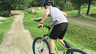
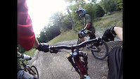
Photos of Casselman Mountain Bike
Videos of Casselman Mountain Bike
trail: Pump Track
0:32 |
980 |
Aug 28, 2015

trail: Trail 11
2:49 |
668 |
Jul 23, 2015

trail: Pump Track
0:43 |
76 |
Jun 6, 2015

trail: Pump Track
0:51 |
395 |
Mar 7, 2015
trail: Pump Track
6:15 |
503 |
Nov 25, 2014

trail: Feature
2:25 |
273 |
Jun 10, 2012

trail: Feature
2:46 |
249 |
Apr 14, 2012
trail: Trail 14
7:07 |
245 |
Nov 24, 2011
Current Trail Warnings
| status | trail | date | condition | user | info |
|---|---|---|---|---|---|
| 205 | Jun 13, 2026 @ 9:42am (America/Toronto) Jun 13, 2026 | Variable | jclarknet | E-Bike Fallen tree | |
| 203 | Jun 13, 2026 @ 9:42am (America/Toronto) Jun 13, 2026 | Variable | jclarknet | E-Bike Fallen tree | |
| 212 | Jun 13, 2026 @ 9:42am (America/Toronto) Jun 13, 2026 | Variable | jclarknet | E-Bike Fallen tree |
Recent Trail Reports
| status | trail | date | condition | info | user |
|---|---|---|---|---|---|
| Trail 1 | May 25, 2026 @ 6:09pm (America/Toronto) May 25, 2026 | Ideal | jamespburger | ||
| Trail 3 | May 25, 2026 @ 6:09pm (America/Toronto) May 25, 2026 | Ideal | jamespburger | ||
| Trail 4 | May 25, 2026 @ 6:09pm (America/Toronto) May 25, 2026 | Ideal | jamespburger | ||
| Trail 5 | May 25, 2026 @ 6:09pm (America/Toronto) May 25, 2026 | Ideal | jamespburger | ||
| Side Winder | May 25, 2026 @ 6:09pm (America/Toronto) May 25, 2026 | Ideal | jamespburger | ||
| Trail 6 | May 25, 2026 @ 6:09pm (America/Toronto) May 25, 2026 | Ideal | jamespburger | ||
| Feature Trail #6 | May 25, 2026 @ 6:09pm (America/Toronto) May 25, 2026 | Ideal | jamespburger | ||
| Trail 6 | May 25, 2026 @ 6:09pm (America/Toronto) May 25, 2026 | Ideal | jamespburger | ||
| Trail 7 | May 25, 2026 @ 6:09pm (America/Toronto) May 25, 2026 | Ideal | jamespburger | ||
| Trail 8 | May 25, 2026 @ 6:09pm (America/Toronto) May 25, 2026 | Ideal | jamespburger |
Activity Feed
| username | action | type | title | date |
|---|---|---|---|---|
| Sauljea | vote | trail | activity #97056147 and 4 more | Jun 15, 2026 @ 11:41am 3 days |
| telecoaster | wishlist | route | activity #97032149 | Jun 15, 2026 @ 4:26am 3 days |
| jclarknet | add | report | activity #96889068 and 2 more | Jun 13, 2026 @ 9:44am Jun 13, 2026 |
| Robby1139 | update | route | activity #95651913 | May 27, 2026 @ 12:01pm May 27, 2026 |
| jamespburger | add | report | activity #95562522 and 14 more | May 26, 2026 @ 7:13am May 26, 2026 |
Recent Comments
| username | type | title | comment | date |
|---|---|---|---|---|
| trail | Même après la pluie les sentiers sont bien,... | Sep 21, 2022 @ 4:26pm Sep 21, 2022 | ||
| trail | Les features dans la 6 sont vraiment bien ,... | Sep 5, 2022 @ 8:12pm Sep 5, 2022 | ||
| trail | C’est parfait pour l’introduction au vélo... | Sep 5, 2022 @ 8:05pm Sep 5, 2022 | ||
| trail | As stated before, the trail is now one way. | Oct 24, 2021 @ 4:23pm Oct 24, 2021 | ||
| report | The next trrrrtrrtrrt. The next time you i M... | May 16, 2021 @ 11:14am May 16, 2021 |
Local Badges
-

10 Green Trails673 awarded -

10 Blue Trails170 awarded -

Epic Ride Climb 2k0 awarded -

Climbing 10k Badge4 awarded -

Climbing 100k Badge0 awarded -

Epic Ride Descent 2k0 awarded
Activity Type Stats
| activitytype | trails | distance | descent | descent distance | total vertical | rating | global rank | state rank | photos | reports | routes | ridelogs |
|---|---|---|---|---|---|---|---|---|---|---|---|---|
| Mountain Bike | 85 | 29 miles | 778 ft | 6 miles | 66 ft | #654 | #21 | 85 | 3,346 | 4 | 10,916 | |
| E-Bike | 81 | 25 miles | 413 ft | 5 miles | 56 ft | #3,632 | #67 | 3,008 | 1 | 204 | ||
| Hike | 36 | 8 miles | 157 ft | 2 miles | 39 ft | #9,539 | #174 | 4 | 2,002 | 149 | ||
| Trail Running | 36 | 8 miles | 157 ft | 2 miles | 39 ft | #9,096 | #156 | 2,002 | 40 | |||
| Dirtbike/Moto | 6 | 8 miles | 384 ft | 3 miles | 72 ft | #707 | #13 | 380 | 10 | |||
| ATV/ORV/OHV | 2 | 3 miles | 10 ft | 1 mile | 49 ft | #845 | #24 | 380 | 6 |
Frequently Asked Questions About Casselman
▼
What are the best places to ride in Casselman?
Casselman has 2 areas to explore for mountain biking. The top rated areas are:
▼
What are the highest rated mountain biking trails in Casselman?
The highest rated mountain biking trails in Casselman are:
- Trail 16 (4.4/5)
- Feature (4.3/5)
- Side Winder (4.2/5)
- Feature Trail #6 (4.2/5)
- 21 (4.2/5)
▼
What is the best time of the year to ride in Casselman?
Based on ride log data, the most popular months to ride in Casselman are:
- September (328 activities)
- August (315 activities)
- July (309 activities)
▼
Where can I park to ride in Casselman?
There are 2 parking locations listed in Casselman. The most popular parking spots are:
Activities
Trails
Points of Interest
- By brenthillier
 NSMBA TRAILFORKS & contributors
 - Admins: OMBA
- #21536 - 4,642 views
- casselman activity log | embed map of Casselman mountain bike trails | casselman mountain biking points of interest
Downloading of trail gps tracks in kml & gpx formats is enabled for Casselman.
You must login to download files.