close
-
Layers w
- Weather Layers
- Pro
- Pro
- Pro
- Pro
- Pro
- Pro
- More Layers
- Pro
- Pro
- Pro
- Pro
-
Upgrade to

3D
Trail Conditions
- Unknown
- Snow Groomed
- Snow Packed
- Snow Covered
- Snow Cover Partial
- Freeze/thaw Cycle
- Icy
- Prevalent Mud
- Wet
- Variable
- Ideal
- Dry
- Very Dry
Trail Flow (Ridden Direction)
Trailforks scans users ridelogs to determine the most popular direction each trail is ridden. A good flowing trail network will have most trails flowing in a single direction according to their intension.
The colour categories are based on what percentage of riders are riding a trail in its intended direction.
The colour categories are based on what percentage of riders are riding a trail in its intended direction.
- > 96%
- > 90%
- > 80%
- > 70%
- > 50%
- < 50%
- bi-directional trail
- no data
Trail Last Ridden
Trailforks scans ridelogs to determine the last time a trail was ridden.
- < 2 days
- < 1 week
- < 2 weeks
- < 1 month
- < 6 months
- > 6 months
Trail Ridden Direction
The intended direction a trail should be ridden.
- Downhill Only
- Downhill Primary
- Both Directions
- Uphill Primary
- Uphill Only
- One Direction
Contribute Details
Colors indicate trail is missing specified detail.
- Description
- Photos
- Description & Photos
- Videos
Trail Popularity ?
Trailforks scans ridelogs to determine which trails are ridden the most in the last 9 months.
Trails are compared with nearby trails in the same city region with a possible 25 colour shades.
Think of this as a heatmap, more rides = more kinetic energy = warmer colors.
- most popular
- popular
- less popular
- not popular
ATV/ORV/OHV Filter
Max Vehicle Width
inches
US Cell Coverage
Legend

Radar Time
Activity Recordings
Trailforks uses anonymized public activity data.
?
Activity Recordings
Trailforks uses anonymized public activity data.
?
Personal Heatmap
▶
Activity Types
all
/
none
▶
Options
2
Date range
month
–
Winter Trails
Warning
A routing network for winter maps does not exist. Selecting trails using the winter trails layer has been disabled.
Missing Trails
Most Popular
Least Popular
Trails are colored based on popularity. The more popular a trail is, the more red. Less popular trails trend towards green.
Jump Magnitude Heatmap
Heatmap of where riders jump on trails. Zoom in to see individual jumps, click circles to view jump details.
BC Backroad Status
![map legend]()
Service Road Atlas is a free to use, community-driven service for viewing and creating reports on the numerous back-country service roads around B.C. and Alberta.

Slope Aspect
Direction the slope faces
Trails Deemphasized
Trails are shown in grey.
Only show trails with no bike usage.
Suggested Layers
Based on selected activity type
Save the current map location and zoom level as your default home location whenever this page is loaded.
Save
No description for Castle Rock has been added yet!
Login or register to submit one.
Activities Click to view
- Mountain Bike
141 trails
- E-Bike
124 trails
- Adaptive Bike
0 trails
- Winter Fat Bike
0 trails
- Hike
144 trails
- Trail Running
144 trails
Region Details
- 99
- 3
- 14
- 23
- 1
- 1
Region Status
Open as of Jun 8, 2026Local Trail Association
Stats
- Avg Trail Rating
- Trails (view details)
- 149
- Trails Mountain Bike
- 141
- Trails E-Bike
- 124
- Trails Hike
- 144
- Trails Trail Running
- 144
- Total Distance
- 81 miles
- Total Descent
- 7,386 ft
- Total Vertical
- 754 ft
- Highest Trailhead
- 6,775 ft
- Reports
- 331
- Photos
- 57
- Ridden Counter
- 6,216
Sub Regions
-
Gateway Mesa Open Space
-
Memmen Ridge Open Space
- 1
-
Metzler Family Open Space
- 4
- 7
-
Phillip Miller Park
- 3
- 10
-
Quarry Mesa Open Space
- 2
- 4
- 5
- 1
- 1
Popular Castle Rock Mountain Biking Trails
• 100 ★ 4.0 • 3,228 ft • 81 ft • 756 •
Popular blue difficulty singletrack. This mountain bike primary trail. On average it takes 3 minutes to complete this trail.
• 100 ★ 5.0 • 1,752 ft • 61 ft • 688 •
Popular blue difficulty singletrack. This mountain bike primary trail. On average it takes 1 minutes to complete this trail.
• 100 ★ 4.4 • 1 mile • 166 ft • 669 •
Popular blue difficulty singletrack. This mountain bike primary trail. On average it takes 9 minutes to complete this trail.
• 100 ★ 5.0 • 1,499 ft • 52 ft • 608 •
Popular blue difficulty singletrack. This mountain bike primary trail. On average it takes 1 minutes to complete this trail.
• 95 ★ 5.0 • 2,260 ft • 44 ft • 579 •
Popular blue difficulty singletrack. This mountain bike primary trail. On average it takes 2 minutes to complete this trail.
• 100 ★ 5.0 • 1,312 ft • 46 ft • 506 •
Popular green difficulty singletrack. This mountain bike primary trail. On average it takes 1 minutes to complete this trail.
Castle Rock Mountain Bike Routes
★ 5.0 • 6 miles • 647 ft • 5 • Loop •
The course is a 6.5 mile loop of flowy, playful trails with consistent terrain changes, short climbs and...
4 miles • 447 ft • 7 •
Relatively flat course behind Target in Castle Rock
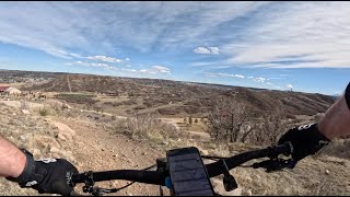
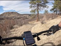
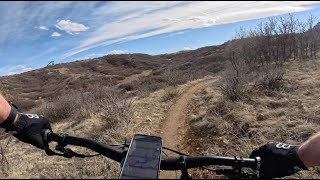
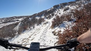
Photos of Castle Rock Mountain Bike
Videos of Castle Rock Mountain Bike
trail: Gold Loop - West
3:36 |
91 |
Mar 18, 2025 , Castle Rock
trail: Purple Loop - North
5:16 |
52 |
Mar 18, 2025 , Castle Rock
trail: Green Loop
4:02 |
97 |
Mar 18, 2025 , Castle Rock
trail: Gold Loop - East
2:01 |
80 |
Jan 15, 2025 , Castle Rock
trail: Purple Loop - South
2:26 |
87 |
Jan 15, 2025 , Castle Rock
Recent Trail Reports
| status | trail | date | condition | info | user |
|---|---|---|---|---|---|
| Purple Loop - South | Jun 8, 2026 @ 4:44pm (America/Denver) Jun 8, 2026 | Ideal | TicoMarley420 | ||
| Green Loop | Jun 8, 2026 @ 4:44pm (America/Denver) Jun 8, 2026 | Dry | TicoMarley420 | ||
| Red Loop | Jun 8, 2026 @ 4:44pm (America/Denver) Jun 8, 2026 | Dry | TicoMarley420 | ||
| Advanced Jump Line | Mar 14, 2026 @ 1:58pm (America/Denver) Mar 14, 2026 | Ideal | scottridesemtbusa | ||
| Session Zone Intermediate | Mar 14, 2026 @ 1:58pm (America/Denver) Mar 14, 2026 | Dry | scottridesemtbusa | ||
| Beginner DH Flow | Mar 14, 2026 @ 1:58pm (America/Denver) Mar 14, 2026 | Dry | scottridesemtbusa | ||
| Session Zone Advanced | Mar 14, 2026 @ 1:58pm (America/Denver) Mar 14, 2026 | Dry | scottridesemtbusa | ||
| Ridgeline Connector | Dec 24, 2025 @ 11:09am (America/Denver) Dec 24, 2025 | Dry | andycochran | ||
| Gold Loop Bonus | Nov 26, 2025 @ 2:57pm (America/Denver) Nov 26, 2025 | Dry | redfoxrun | ||
| Gold Loop - East | Nov 26, 2025 @ 2:57pm (America/Denver) Nov 26, 2025 | Dry | redfoxrun |
Activity Feed
| username | action | type | title | date |
|---|---|---|---|---|
| TicoMarley420 | add | report | activity #96585826 and 2 more | Jun 8, 2026 @ 10:31pm Jun 8, 2026 |
| LayneqJbAvC | ridden | trail | activity #94607248 | May 12, 2026 @ 8:39pm May 12, 2026 |
| redfoxrun | add | photo | activity #94177558 | May 6, 2026 @ 2:21pm May 6, 2026 |
| MarcioXVbtTw | wishlist | route | activity #94045892 | May 4, 2026 @ 1:43pm May 4, 2026 |
| redfoxrun | comment | trail | activity #93714904 | Apr 30, 2026 @ 8:35am Apr 30, 2026 |
Recent Comments
| username | type | title | comment | date |
|---|---|---|---|---|
| trail | This trail has a lot of potential but in its... | Apr 30, 2026 @ 8:35am Apr 30, 2026 | ||
| trail | This was a bit of a letdown, very loose and... | Oct 2, 2024 @ 11:51am Oct 2, 2024 | ||
| trail | I’mafewWww | Aug 7, 2023 @ 12:37pm Aug 7, 2023 | ||
| trail | All cyclocross features are blocked off or... | Jul 13, 2022 @ 12:58pm Jul 13, 2022 | ||
| trail | Super fun line with very boostable jumps,... | Jul 13, 2022 @ 11:39am Jul 13, 2022 |
Local Badges
-

Epic Ride Climb 2k28 awarded -

Climbing 10k Badge19 awarded -

Climbing 100k Badge0 awarded -

Epic Ride Descent 2k27 awarded -

Descent 10k Badge19 awarded -

Descent 100k Badge0 awarded
Bike & Skill Parks
| name | type | city | rating |
|---|---|---|---|
| Rhyolite Bike Park | skill park | Castle Rock |
Activity Type Stats
| activitytype | trails | distance | descent | descent distance | total vertical | rating | global rank | state rank | photos | reports | routes | ridelogs |
|---|---|---|---|---|---|---|---|---|---|---|---|---|
| Mountain Bike | 141 | 76 miles | 6,985 ft | 32 miles | 755 ft | #1,408 | #534 | 60 | 330 | 2 | 4,916 | |
| E-Bike | 124 | 64 miles | 5,696 ft | 27 miles | 686 ft | #2,137 | #945 | 305 | 137 | |||
| Hike | 144 | 80 miles | 7,047 ft | 33 miles | 755 ft | #753 | #344 | 312 | 1,305 | |||
| Trail Running | 144 | 80 miles | 7,047 ft | 33 miles | 755 ft | #2,028 | #653 | 312 | 923 |
Frequently Asked Questions About Castle Rock
▼
What are the best places to ride in Castle Rock?
Castle Rock has 6 areas to explore for mountain biking. The top rated areas are:
▼
What are the highest rated mountain biking trails in Castle Rock?
The highest rated mountain biking trails in Castle Rock are:
- Uphill Access (4.2/5)
- Rhyolite (4.2/5)
- Advanced Jump Line (4.2/5)
- Gold Loop Access (4.1/5)
- Red Loop (4.1/5)
▼
What is the best time of the year to ride in Castle Rock?
Based on ride log data, the most popular months to ride in Castle Rock are:
- June (45 activities)
- July (24 activities)
- September (22 activities)
▼
Where can I park to ride in Castle Rock?
Activities
Trails
Points of Interest
- By canadaka
 Trailforks & contributors
 - Admins: apply
- #5213 - 8,160 views
- castle rock activity log | embed map of Castle Rock mountain bike trails | castle rock mountain biking points of interest
Downloading of trail gps tracks in kml & gpx formats is enabled for Castle Rock.
You must login to download files.