close
-
Layers w
- Weather Layers
- Pro
- Pro
- Pro
- Pro
- Pro
- Pro
- More Layers
- Pro
- Pro
- Pro
- Pro
-
Upgrade to

3D
Trail Conditions
- Unknown
- Snow Groomed
- Snow Packed
- Snow Covered
- Snow Cover Partial
- Freeze/thaw Cycle
- Icy
- Prevalent Mud
- Wet
- Variable
- Ideal
- Dry
- Very Dry
Trail Flow (Ridden Direction)
Trailforks scans users ridelogs to determine the most popular direction each trail is ridden. A good flowing trail network will have most trails flowing in a single direction according to their intension.
The colour categories are based on what percentage of riders are riding a trail in its intended direction.
The colour categories are based on what percentage of riders are riding a trail in its intended direction.
- > 96%
- > 90%
- > 80%
- > 70%
- > 50%
- < 50%
- bi-directional trail
- no data
Trail Last Ridden
Trailforks scans ridelogs to determine the last time a trail was ridden.
- < 2 days
- < 1 week
- < 2 weeks
- < 1 month
- < 6 months
- > 6 months
Trail Ridden Direction
The intended direction a trail should be ridden.
- Downhill Only
- Downhill Primary
- Both Directions
- Uphill Primary
- Uphill Only
- One Direction
Contribute Details
Colors indicate trail is missing specified detail.
- Description
- Photos
- Description & Photos
- Videos
Trail Popularity ?
Trailforks scans ridelogs to determine which trails are ridden the most in the last 9 months.
Trails are compared with nearby trails in the same city region with a possible 25 colour shades.
Think of this as a heatmap, more rides = more kinetic energy = warmer colors.
- most popular
- popular
- less popular
- not popular
ATV/ORV/OHV Filter
Max Vehicle Width
inches
US Cell Coverage
Legend

Radar Time
Activity Recordings
Trailforks uses anonymized public activity data.
?
Activity Recordings
Trailforks uses anonymized public activity data.
?
Personal Heatmap
▶
Activity Types
all
/
none
▶
Options
2
Date range
month
–
Winter Trails
Warning
A routing network for winter maps does not exist. Selecting trails using the winter trails layer has been disabled.
Missing Trails
Most Popular
Least Popular
Trails are colored based on popularity. The more popular a trail is, the more red. Less popular trails trend towards green.
Jump Magnitude Heatmap
Heatmap of where riders jump on trails. Zoom in to see individual jumps, click circles to view jump details.
BC Backroad Status
![map legend]()
Service Road Atlas is a free to use, community-driven service for viewing and creating reports on the numerous back-country service roads around B.C. and Alberta.

Slope Aspect
Direction the slope faces
Trails Deemphasized
Trails are shown in grey.
Only show trails with no bike usage.
Suggested Layers
Based on selected activity type
Save the current map location and zoom level as your default home location whenever this page is loaded.
Save
No description for Castlewellan has been added yet!
Login or register to submit one.
AKA: Caisleán Uidhilín
This region uses the Uk/Euro style trail grading system.
Activities Click to view
- Mountain Bike
44 trails
- E-Bike
43 trails
- Gravel Bike
0 trails
- Adaptive Bike
0 trails
- Winter Fat Bike
0 trails
- Horse
18 trails
- Hike
20 trails
- Trail Running
20 trails
Region Details
- 18
- 3
- 18
- 5
Region Status
Open as of Apr 18, 2026Local Trail Association
Stats
- Avg Trail Rating
- Trails (view details)
- 45
- Trails Mountain Bike
- 44
- Trails E-Bike
- 43
- Trails Horse
- 18
- Trails Hike
- 20
- Trails Trail Running
- 20
- Total Distance
- 23 miles
- Total Descent
- 3,375 ft
- Total Vertical
- 585 ft
- Highest Trailhead
- 882 ft
- Reports
- 749
- Photos
- 71
- Ridden Counter
- 8,189
Sub Regions
-
Castlewellan Forest Park
- 3
- 17
- 4
Popular Castlewellan Mountain Biking Trails
• 95 ★ 1.8 • 1,804 ft • 26 ft • 379 •
Popular red difficulty machine groomed. This mountain bike primary trail can be used one direction and has a moderate overall physical rating with a 26 ft blue climb. It features rock garden. Trail visibility is always easy to follow. On average it takes 2 minutes to complete this trail.
• 95 ★ 3.0 • 3,028 ft • 11 ft • 374 •
Popular blue difficulty machine groomed. This mountain bike primary trail can be used one direction and has a easy overall physical rating with a 11 ft blue climb. Trail visibility is always easy to follow. On average it takes 3 minutes to complete this trail.
• 85 ★ 2.8 • 1,368 ft • 24 ft • 363 •
Popular red difficulty machine groomed. This mountain bike primary trail can be used one direction and has a easy overall physical rating with a 24 ft green climb. It features berm and drop. Trail visibility is always easy to follow. On average it takes 1 minutes to complete this trail.
• 80 ★ 2.2 • 1,913 ft • 59 ft • 360 •
Popular red difficulty machine groomed. This mountain bike primary trail can be used one direction and has a moderate overall physical rating with a 59 ft blue climb. It features berm and jump. Trail visibility is always easy to follow. On average it takes 4 minutes to complete this trail.
• 90 ★ 2.4 • 801 ft • 44 ft • 340 •
Popular red difficulty machine groomed. This mountain bike primary trail can be used one direction and has a moderate overall physical rating with a 44 ft blue climb. It features jump. Trail visibility is always easy to follow. On average it takes 1 minutes to complete this trail.
• 100 ★ 3.5 • 3,376 ft • 56 ft • 332 •
Popular red difficulty machine groomed. This mountain bike primary trail can be used one direction and has a moderate overall physical rating with a 56 ft blue climb. It features berm, jump and rock garden. Trail visibility is always easy to follow. On average it takes 4 minutes to complete this trail.
• 45 ★ 2.5 • 4,587 ft • 63 ft • 326 •
Moderately popular red difficulty machine groomed. This mountain bike primary trail can be used one direction and has a moderate overall physical rating. It features berm and rock garden. Trail visibility is always easy to follow. On average it takes 5 minutes to complete this trail.
• 80 ★ 3.6 • 1,693 ft • 26 ft • 323 •
This enjoys the initial flowing singletrack and incredible panoramic views found on Castlewellan's blue trail before splitting off and ascending behind Castlewellan Castle and past a number of little known smaller lakes. The fun then...
Castlewellan Mountain Bike Routes
★ 4.0 • 9 miles • 949 ft • 42 • Loop •
This enjoys the initial flowing singletrack and incredible panoramic views found on Castlewellan's blue...
★ 3.0 • 13 miles • 1,527 ft • 56 • Loop •
This loop includes both the red and black trail centre loops, while overlapping as little as possible.
3 miles • 152 ft • 13 • Loop •
3 miles • 156 ft • 11 • Loop •
• 13 miles • 2,028 ft • 21 •
• 12 miles • 1,932 ft • 16 •
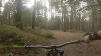
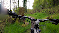
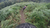
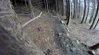
Photos of Castlewellan Mountain Bike
Videos of Castlewellan Mountain Bike

trail: Helter Skelter upper
2:56 |
79 |
Mar 25, 2022

trail: Red Trail 10
5:34 |
170 |
Sep 20, 2019
trail: Naturalist
0:47 |
276 |
Oct 6, 2018
trail: Red Trail 12
0:01 |
246 |
May 23, 2018

trail: Red Trail 10
5:24 |
910 |
Sep 21, 2017
trail: Naturalist
0:15 |
248 |
Sep 13, 2015

trail: Naturalist
5:26 |
377 |
Jul 29, 2015
trail: Red Trail 10
0:03 |
157 |
Mar 15, 2015
Recent Trail Reports
| status | trail | date | condition | info | user |
|---|---|---|---|---|---|
| Black Trail 3 | Apr 12, 2026 @ 11:19am (Europe/Isle_of_Man) Apr 12, 2026 | Wet | Screwjack81 | ||
| Red Trail 10 | Apr 12, 2026 @ 11:19am (Europe/Isle_of_Man) Apr 12, 2026 | Wet | Screwjack81 | ||
| Red Trail 9 | Apr 12, 2026 @ 11:19am (Europe/Isle_of_Man) Apr 12, 2026 | Variable | Screwjack81 | ||
| The Hurt Locker Bottom | Apr 12, 2026 @ 11:19am (Europe/Isle_of_Man) Apr 12, 2026 | Variable | Screwjack81 | ||
| Blue Trail 2 | Apr 12, 2026 @ 11:19am (Europe/Isle_of_Man) Apr 12, 2026 | Wet | Screwjack81 | ||
| The Hurt Locker Top | Apr 12, 2026 @ 12:22pm (Europe/London) Apr 12, 2026 | Unknown | Robbo89 | ||
| Red Trail 8 | Mar 2, 2026 @ 11:20am (Europe/London) Mar 2, 2026 | Ideal | cleggycyclist | ||
| Red Trail 11 | Feb 4, 2026 @ 6:28pm (Europe/London) Feb 4, 2026 | Unknown | jonathancross | ||
| Red Trail 12 | Nov 16, 2025 @ 1:37pm (Europe/London) Nov 16, 2025 | Unknown | typhoongb | ||
| Forest Road | Aug 22, 2025 @ 4:27pm (Europe/London) Aug 22, 2025 | Dry | chrisnolongerinleedsuk |
Activity Feed
| username | action | type | title | date |
|---|---|---|---|---|
| DanielMTB123456789 | ridden | trail | activity #95882876 and 12 more | May 30, 2026 @ 1:29pm May 30, 2026 |
| PhilipcT8W73 | vote | route | activity #95104375 | May 20, 2026 @ 6:45am May 20, 2026 |
| Screwjack81 | add | report | activity #92483220 and 4 more | Apr 12, 2026 @ 10:31am Apr 12, 2026 |
| Screwjack81 | comment | trail | activity #92476771 | Apr 12, 2026 @ 8:38am Apr 12, 2026 |
| Robbo89 | add | report | activity #92460147 | Apr 12, 2026 @ 4:22am Apr 12, 2026 |
Recent Comments
| username | type | title | comment | date |
|---|---|---|---|---|
| trail | Don’t bother. It’s over grown and not rideable | Apr 12, 2026 @ 8:38am Apr 12, 2026 | ||
| trail | WOULD NOT RIDE THIS TRAIL Spent a good 20... | Jul 23, 2022 @ 7:34am Jul 23, 2022 | ||
| trail | Attempted to ride wingnut today. Brambles have... | Jul 18, 2021 @ 2:59pm Jul 18, 2021 | ||
| trail | Haven't ridden many pump tracks but not... | Apr 13, 2021 @ 1:44am Apr 13, 2021 |
Local Badges
-

Epic Ride Climb 2k8 awarded -

Climbing 10k Badge21 awarded -

Climbing 100k Badge1 awarded -

Epic Ride Descent 2k8 awarded -

Descent 10k Badge21 awarded -

Descent 100k Badge1 awarded
Activity Type Stats
| activitytype | trails | distance | descent | descent distance | total vertical | rating | global rank | state rank | photos | reports | routes | ridelogs |
|---|---|---|---|---|---|---|---|---|---|---|---|---|
| Mountain Bike | 44 | 23 miles | 3,307 ft | 12 miles | 554 ft | #3,051 | #97 | 71 | 749 | 5 | 3,818 | |
| E-Bike | 43 | 23 miles | 3,366 ft | 12 miles | 584 ft | #965 | #50 | 721 | 3 | 481 | ||
| Horse | 18 | 13 miles | 1,493 ft | 6 miles | 554 ft | #1,233 | #59 | 68 | ||||
| Hike | 20 | 13 miles | 1,572 ft | 6 miles | 584 ft | #7,154 | #202 | 710 | 40 | |||
| Trail Running | 20 | 13 miles | 1,572 ft | 6 miles | 584 ft | #6,504 | #181 | 710 | 170 |
Frequently Asked Questions About Castlewellan
▼
What are the best places to ride in Castlewellan?
Castlewellan has 1 areas to explore for mountain biking. The top rated areas are:
▼
What are the highest rated mountain biking trails in Castlewellan?
The highest rated mountain biking trails in Castlewellan are:
- Naturalist (4.1/5)
- Black Trail 1 (4/5)
- Helter Skelter upper (4/5)
- Wingnut (4/5)
- Red Trail 8 (3.8/5)
▼
What is the best time of the year to ride in Castlewellan?
Based on ride log data, the most popular months to ride in Castlewellan are:
- June (38 activities)
- October (32 activities)
- July (30 activities)
▼
Where can I park to ride in Castlewellan?
There are 2 parking locations listed in Castlewellan. The most popular parking spots are:
Activities
- By brenthillier
 NSMBA TRAILFORKS & contributors
 - Admins: GRASS
- #4366 - 7,751 views
- castlewellan activity log | embed map of Castlewellan mountain bike trails | castlewellan mountain biking points of interest
Downloading of trail gps tracks in kml & gpx formats is enabled for Castlewellan.
You must login to download files.