close
-
Layers w
- Weather Layers
- Pro
- Pro
- Pro
- Pro
- Pro
- Pro
- More Layers
- Pro
- Pro
- Pro
- Pro
-
Upgrade to

3D
Trail Conditions
- Unknown
- Snow Groomed
- Snow Packed
- Snow Covered
- Snow Cover Partial
- Freeze/thaw Cycle
- Icy
- Prevalent Mud
- Wet
- Variable
- Ideal
- Dry
- Very Dry
Trail Flow (Ridden Direction)
Trailforks scans users ridelogs to determine the most popular direction each trail is ridden. A good flowing trail network will have most trails flowing in a single direction according to their intension.
The colour categories are based on what percentage of riders are riding a trail in its intended direction.
The colour categories are based on what percentage of riders are riding a trail in its intended direction.
- > 96%
- > 90%
- > 80%
- > 70%
- > 50%
- < 50%
- bi-directional trail
- no data
Trail Last Ridden
Trailforks scans ridelogs to determine the last time a trail was ridden.
- < 2 days
- < 1 week
- < 2 weeks
- < 1 month
- < 6 months
- > 6 months
Trail Ridden Direction
The intended direction a trail should be ridden.
- Downhill Only
- Downhill Primary
- Both Directions
- Uphill Primary
- Uphill Only
- One Direction
Contribute Details
Colors indicate trail is missing specified detail.
- Description
- Photos
- Description & Photos
- Videos
Trail Popularity ?
Trailforks scans ridelogs to determine which trails are ridden the most in the last 9 months.
Trails are compared with nearby trails in the same city region with a possible 25 colour shades.
Think of this as a heatmap, more rides = more kinetic energy = warmer colors.
- most popular
- popular
- less popular
- not popular
ATV/ORV/OHV Filter
Max Vehicle Width
inches
US Cell Coverage
Legend

Radar Time
Activity Recordings
Trailforks uses anonymized public activity data.
?
Activity Recordings
Trailforks uses anonymized public activity data.
?
Personal Heatmap
▶
Activity Types
all
/
none
▶
Options
2
Date range
month
–
Winter Trails
Warning
A routing network for winter maps does not exist. Selecting trails using the winter trails layer has been disabled.
Missing Trails
Most Popular
Least Popular
Trails are colored based on popularity. The more popular a trail is, the more red. Less popular trails trend towards green.
Jump Magnitude Heatmap
Heatmap of where riders jump on trails. Zoom in to see individual jumps, click circles to view jump details.
BC Backroad Status
![map legend]()
Service Road Atlas is a free to use, community-driven service for viewing and creating reports on the numerous back-country service roads around B.C. and Alberta.

Slope Aspect
Direction the slope faces
Trails Deemphasized
Trails are shown in grey.
Only show trails with no bike usage.
Suggested Layers
Based on selected activity type
Save the current map location and zoom level as your default home location whenever this page is loaded.
Save
No description for Cathedral has been added yet!
Login or register to submit one.
 google parking directions
google parking directions Region Supporters & Maintainers
Activities Click to view
- Mountain Bike
27 trails
- Horse
10 trails
- Hike
29 trails
- Trail Running
29 trails
Region Details
- 9
- 13
- 2
Region Status
Open as of Jun 4, 2026Local Trail Association
Stats
- Avg Trail Rating
- Global Ranking
- #371
- Trails (view details)
- 26
- Trails Mountain Bike
- 27
- Trails Horse
- 10
- Trails Hike
- 29
- Trails Trail Running
- 29
- Total Distance
- 21 miles
- Total Descent
- 3,220 ft
- Total Vertical
- 841 ft
- Highest Trailhead
- 4,800 ft
- Reports
- 2,724
- Photos
- 701
- Ridden Counter
- 12,416
Popular Cathedral Mountain Biking Trails
• 90 ★ 4.6 • 3 miles • 300 ft • 6,648 •
Beginner 20%, intermediate 40%, advanced 20% and expert 20%, 2.62 mile very technical MTB trail which is a bi-directional singletrack, that is up and down with about 400 yards of technical exposed and really steep sections a lesser...
• 95 ★ 4.5 • 2 miles • 106 ft • 6,525 •
Beginner 10%, intermediate 70% and advanced 20%, twisty with numerous up and down sections of trail that cross a number of dry washes. The trail tread is mostly packed dirt mixed with rocks. There are also several sections of slickrock...
• 100 ★ 3.4 • 1,555 ft • 0 ft • 6,090 •
Intermediate 90% and advanced 10%, 1/3 mile MTB trail which is a bi-directional singletrack that is a slightly twisty trail with a couple of slightly technical spots that will be a little challenging to a lesser skilled rider. The trail...
• 90 ★ 4.5 • 1 mile • 15 ft • 6,003 •
Mostly downhill, fast and fun, with some rocks thrown in here and there. This section is really fun as a downhill, but also goes just fine as an uphill. Keep in mind if you ride down, you get closer and closer to the trail head, and...
• 85 ★ 3.9 • 4,104 ft • 46 ft • 4,236 •
Beginner 20%, intermediate 70% and advanced 10%, .78 mile MTB trail which is a bi-directional singletrack that is twisty and up and down. There are some technical sections that lesser skilled riders will walk to a avoid injury.. The...
• 85 ★ 3.4 • 856 ft • 37 ft • 4,213 •
This short 900' connector singletrack takes you from the point parking lot to the trail on a narrow packed dirt trail. It also takes you to the lower south end of the Vista trail. The trail makes for a good connector trail and is used...
• 85 ★ 3.7 • 1,946 ft • 88 ft • 3,700 •
Intermediate 90% and advanced 10%, 1/3 mile MTB trail which is a bi-directional singletrack that is a slightly twisty trail with a couple of slightly technical spots that will be a little challenging to a lesser skilled rider. The trail...
• 80 ★ 3.7 • 702 ft • 64 ft • 2,932 •
The Point Trail is broken up into 2 parts. This is the upper part which is OK for bikes and is a challenge up and a lot of fun down. The trail appears very short on the map, and it is if you just ride straight down it, which is fun...
Cathedral Mountain Bike Routes
★ 4.0 • 10 miles • 897 ft • 7 • Loop •
Sedona Classics! Featuring some long standing favorites like Slim Shady, , Llama, and trails. There are a...
12 miles • 1,136 ft • 6 • Loop •
Moderate route that starts at the Parking Area. There are small brown signs through the neighborhood to...
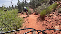
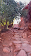
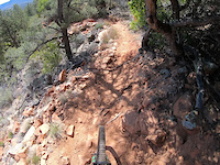
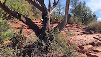
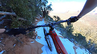
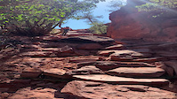
Photos of Cathedral Mountain Bike
Videos of Cathedral Mountain Bike
trail: Easy Breezy
0:10 |
24 |
May 8, 2026

trail: Hardline
0:12 |
52 |
Jan 16, 2026
trail: Hiline
0:16 |
34 |
Nov 1, 2025
trail: Made In The Shade
5:59 |
38 |
Apr 12, 2025
trail: Hiline
0:46 |
68 |
Dec 28, 2024
trail: Hiline
0:16 |
71 |
Jun 23, 2024
trail: Hiline
0:10 |
|
Sep 20, 2022

trail: Hiline
12:03 |
35 |
Jan 20, 2022
Recent Trail Reports
| status | trail | date | condition | info | user |
|---|---|---|---|---|---|
| Temp - Easy | Jun 4, 2026 @ 9:18am (America/Phoenix) Jun 4, 2026 | Very Dry | ultrarunnergirl | ||
| Yavapai Point | May 23, 2026 @ 9:42am (America/Phoenix) May 23, 2026 | Dry | YekaiLuke | ||
| Kaibab | May 23, 2026 @ 9:42am (America/Phoenix) May 23, 2026 | Dry | YekaiLuke | ||
| Hermit | May 23, 2026 @ 9:42am (America/Phoenix) May 23, 2026 | Dry | YekaiLuke | ||
| Templeton North | May 23, 2026 @ 9:42am (America/Phoenix) May 23, 2026 | Dry | YekaiLuke | ||
| Cathedral Rock | May 19, 2026 @ 5:36am (Pacific/Midway) May 19, 2026 | Dry | steuer | ||
| Ht Trail | May 19, 2026 @ 5:36am (Pacific/Midway) May 19, 2026 | Dry | steuer | ||
| Easy Breezy | May 13, 2026 @ 2:51pm (America/Phoenix) May 13, 2026 | Very Dry | ultrarunnergirl | ||
| Hiline | Apr 3, 2026 @ 3:23pm (America/Phoenix) Apr 3, 2026 | Ideal | Bricklin69 | ||
| Coconino | Apr 3, 2026 @ 3:23pm (America/Phoenix) Apr 3, 2026 | Ideal | Bricklin69 |
Activity Feed
| username | action | type | title | date |
|---|---|---|---|---|
| Jimmylevans | wishlist | route | activity #97637660 | Jun 23, 2026 @ 10:40am 2 days |
| Pjstrns | wishlist | route | activity #97604966 | Jun 22, 2026 @ 9:56pm 2 days |
| RicardoRKZZBY | wishlist | trail | activity #97475053 | Jun 21, 2026 @ 5:34am Jun 21, 2026 |
| absolutebikes1 | difficultyvote | trail | activity #97141509 and 1 more | Jun 16, 2026 @ 3:30pm Jun 16, 2026 |
| cindit | wishlist | trail | activity #96973509 and 3 more | Jun 14, 2026 @ 8:45am Jun 14, 2026 |
Recent Comments
| username | type | title | comment | date |
|---|---|---|---|---|
| trail | Skip. No shade. Blown out a little. Just not... | May 11, 2026 @ 2:19pm May 11, 2026 | ||
| trail | Still one of my faves. Many super sketch dh... | May 11, 2026 @ 2:17pm May 11, 2026 | ||
| trail | The skill required is similar to hiline and... | Apr 10, 2026 @ 2:44pm Apr 10, 2026 | ||
| trail | The first 15% of the trail is a solid black... | Apr 7, 2026 @ 10:57am Apr 7, 2026 | ||
| trail | Recent trail work has made this trail better... | Feb 24, 2026 @ 12:09pm Feb 24, 2026 |
Nearby Areas
| name | distance | ||||
|---|---|---|---|---|---|
| Turkey Creek | 7 | 10 | 1.7 km | ||
| Bell Rock | 3 | 7 | 2 | 1.8 km | |
| Broken Arrow | 1 | 5 | 7 | 2 | 2.1 km |
| Carroll Canyon | 9 | 9 | 2.2 km | ||
| Red Rock State Park | 1 | 2.3 km |
Local Badges
-

Completionist0 awarded
Activity Type Stats
| activitytype | trails | distance | descent | descent distance | total vertical | rating | global rank | state rank | photos | reports | routes | ridelogs |
|---|---|---|---|---|---|---|---|---|---|---|---|---|
| Mountain Bike | 27 | 21 miles | 3,219 ft | 10 miles | 689 ft | #371 | 710 | 2,719 | 1 | 2,820 | ||
| Horse | 10 | 10 miles | 1,168 ft | 4 miles | 381 ft | #2,762 | #1,561 | 1 | 1,815 | 1 | ||
| Hike | 29 | 21 miles | 3,219 ft | 10 miles | 840 ft | #2,265 | #863 | 22 | 2,680 | 1 | 1,028 | |
| Trail Running | 29 | 21 miles | 3,219 ft | 10 miles | 840 ft | #5,509 | #1,697 | 2,680 | 1 | 139 |
Frequently Asked Questions About Cathedral
▼
What are the highest rated mountain biking trails in Cathedral?
The highest rated mountain biking trails in Cathedral are:
- Hiline (4.5/5)
- Slim Shady (North) (4.5/5)
- Slim Shady (South) (4.5/5)
- Hardline (4.3/5)
- Baldwin (4.2/5)
▼
Where can I park to ride in Cathedral?
There are 4 parking locations listed in Cathedral. The most popular parking spots are: View all parking and trailhead locations on the map to plan your visit.
▼
What is the longest trail in Cathedral?
The longest trail in Cathedral is Transept at 3.2 miles. View all trails sorted by distance.
▼
What are the best & highest rated hiking trails in Cathedral?
The best hiking trails in Cathedral are: View all hiking trails sorted by popularity score.
Activities
Trails
- By msmcfate
 TRAILFORKS & contributors
 - Admins: apply
- #70106 - 1,048 views
- cathedral activity log | embed map of Cathedral mountain bike trails | cathedral mountain biking points of interest
Downloading of trail gps tracks in kml & gpx formats is enabled for Cathedral.
You must login to download files.