close
-
Layers w
- Weather Layers
- Pro
- Pro
- Pro
- Pro
- Pro
- Pro
- More Layers
- Pro
- Pro
- Pro
- Pro
-
Upgrade to

3D
Trail Conditions
- Unknown
- Snow Groomed
- Snow Packed
- Snow Covered
- Snow Cover Partial
- Freeze/thaw Cycle
- Icy
- Prevalent Mud
- Wet
- Variable
- Ideal
- Dry
- Very Dry
Trail Flow (Ridden Direction)
Trailforks scans users ridelogs to determine the most popular direction each trail is ridden. A good flowing trail network will have most trails flowing in a single direction according to their intension.
The colour categories are based on what percentage of riders are riding a trail in its intended direction.
The colour categories are based on what percentage of riders are riding a trail in its intended direction.
- > 96%
- > 90%
- > 80%
- > 70%
- > 50%
- < 50%
- bi-directional trail
- no data
Trail Last Ridden
Trailforks scans ridelogs to determine the last time a trail was ridden.
- < 2 days
- < 1 week
- < 2 weeks
- < 1 month
- < 6 months
- > 6 months
Trail Ridden Direction
The intended direction a trail should be ridden.
- Downhill Only
- Downhill Primary
- Both Directions
- Uphill Primary
- Uphill Only
- One Direction
Contribute Details
Colors indicate trail is missing specified detail.
- Description
- Photos
- Description & Photos
- Videos
Trail Popularity ?
Trailforks scans ridelogs to determine which trails are ridden the most in the last 9 months.
Trails are compared with nearby trails in the same city region with a possible 25 colour shades.
Think of this as a heatmap, more rides = more kinetic energy = warmer colors.
- most popular
- popular
- less popular
- not popular
ATV/ORV/OHV Filter
Max Vehicle Width
inches
US Cell Coverage
Legend

Radar Time
Activity Recordings
Trailforks uses anonymized public activity data.
?
Activity Recordings
Trailforks uses anonymized public activity data.
?
Personal Heatmap
▶
Activity Types
all
/
none
▶
Options
2
Date range
month
–
Winter Trails
Warning
A routing network for winter maps does not exist. Selecting trails using the winter trails layer has been disabled.
Missing Trails
Most Popular
Least Popular
Trails are colored based on popularity. The more popular a trail is, the more red. Less popular trails trend towards green.
Jump Magnitude Heatmap
Heatmap of where riders jump on trails. Zoom in to see individual jumps, click circles to view jump details.
BC Backroad Status
![map legend]()
Service Road Atlas is a free to use, community-driven service for viewing and creating reports on the numerous back-country service roads around B.C. and Alberta.

Slope Aspect
Direction the slope faces
Trails Deemphasized
Trails are shown in grey.
Only show trails with no bike usage.
Suggested Layers
Based on selected activity type
Save the current map location and zoom level as your default home location whenever this page is loaded.
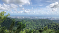
SaveQueen city of the south welcome to cebu!
Activities Click to view
- Mountain Bike
36 trails
- E-Bike
3 trails
- Adaptive Bike
0 trails
- Winter Fat Bike
0 trails
- Hike
40 trails
- Trail Running
40 trails
Region Details
- 14
- 14
- 7
Region Status
Caution as of Feb 12, 2026Stats
- Avg Trail Rating
- Trails (view details)
- 38
- Trails Mountain Bike
- 36
- Trails E-Bike
- 3
- Trails Hike
- 40
- Trails Trail Running
- 40
- Total Distance
- 79 miles
- Total Descent
- 36,379 ft
- Total Vertical
- 2,373 ft
- Highest Trailhead
- 2,405 ft
- Reports
- 15
- Photos
- 144
- Ridden Counter
- 214
Sub Regions
-
Adlaon
- 3
-
Barili
- 1
- 1
-
Buhisan Trial Head
- 1
-
Liloan/Lacion
- 4
- 2
-
Mount Babag
- 1
-
Soltana Bike Run Park
Popular Cebu City Mountain Biking Trails
• 90 ★ 5.0 • 2 miles • 169 ft • 17 •
This is an old xTERRA Bike Route way back 2013-2015.
• 100 ★ 0.0 • 2 miles • 20 ft • 16 •
Bajang trail an access road from Pardo to Toong, but the road is still not completely fixed yet, there are parts here that has pave already or cement, but major of the area is still off road mixed of loose rocks, steep terrain, Muddy...
• 85 ★ 5.0 • 3 miles • 449 ft • 11 •
Snake Road route. loose ground, Fire Roads, with lots of descends and uphill climbs... Good for XC or Enduro.
• 5 ★ 5.0 • 2 miles • 54 ft • 10 •
All Mountain trail, unmanaged single track trail with huge rock gardens, drops and snakes. really watch out for the snakes.
• 5 ★ 5.0 • 5 miles • 388 ft • 10 •
From Kan-irag exiting to Pulangbato near Talamban. It's good for newbies wanted to experience a good enduro ride.
• 5 ★ 5.0 • 4,615 ft • 47 ft • 8 •
River crossing XC ride, this ride features loose and fire roads.
• 5 ★ 5.0 • 3 miles • 653 ft • 7 •
if you plan to ride this bike all the way, the route starts at busay, going to RCPI tower whatever ways you can go to RCPI as long as you reach RCPI, go straight after reaching RCPI tower going to BOCAUE Peak there is no other trail...
Cebu City Mountain Bike Routes
★ 5.0 • 2 miles • 247 ft • 0 •
if you want a quick XC-Enduro trail sa walay pagduha2x marecommend ni namo with a nice city view and sea...
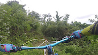
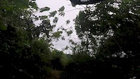
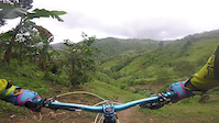
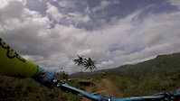
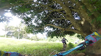
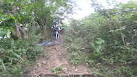
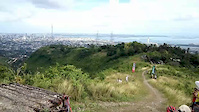
Photos of Cebu City Mountain Bike
Videos of Cebu City Mountain Bike
trail: Mt. Babag to Napo
0:05 |
|
Sep 14, 2024
trail: Bitlang - Batoon
0:55 |
244 |
Mar 5, 2017
trail: Bitlang - Batoon
0:56 |
158 |
Mar 5, 2017
trail: Sudlon 2 a.k.a Radar
0:57 |
205 |
Mar 5, 2017
trail: Sibugay
0:58 |
169 |
Mar 5, 2017
trail: Bitlang - Batoon
0:58 |
113 |
Mar 5, 2017
trail: Sudlon 2 a.k.a Radar
0:30 |
220 |
Mar 5, 2017
trail: Bitlang - Batoon
5:20 |
229 |
Dec 9, 2016
Recent Trail Reports
| status | trail | date | condition | info | user |
|---|---|---|---|---|---|
| Bajang Trail in Buhisan | Feb 12, 2026 @ 10:24pm (Asia/Manila) Feb 12, 2026 | Unknown | mtbridesincebu | ||
| Passing TuloTulo Cave Trail | May 31, 2022 @ 3:10pm May 31, 2022 | Ideal | mtbridesincebu | ||
| xTerra Liloan XC/ENDURO Trail(Mini Chocolate hills in cebu) | Mar 31, 2022 @ 3:44pm Mar 31, 2022 | Ideal | mtbridesincebu | ||
| Pitogo 3 | Mar 20, 2021 @ 11:49am Mar 20, 2021 | Dry | vyap87 | ||
| La tegola Trail | Dec 5, 2020 @ 9:54pm Dec 5, 2020 | Wet | mtbridesincebu | ||
| Lataban XC Ride | Jun 7, 2019 @ 2:19am Jun 7, 2019 | Variable | vyap87 | ||
| Kan-irag Exit to Pulangbato | Oct 6, 2018 @ 2:28pm Oct 6, 2018 | Unknown | mtbridesincebu | ||
| M Lhuillier Trail - River Exit | Aug 18, 2018 @ 4:10pm Aug 18, 2018 | Wet | mtbridesincebu |
Activity Feed
| username | action | type | title | date |
|---|---|---|---|---|
| Deogenes6y8Y6F | wishlist | region | activity #94484755 | May 11, 2026 @ 3:05am May 11, 2026 |
| jeypss | ridden | trail | activity #92295750 | Apr 9, 2026 @ 6:42pm Apr 9, 2026 |
| rtrsdsmknndhy | wishlist | trail | activity #91743391 | Apr 1, 2026 @ 9:01pm Apr 1, 2026 |
| mtbridesincebu | add | report | activity #88776961 | Feb 12, 2026 @ 6:25am Feb 12, 2026 |
| trailforks | add | video | activity #87293678 | Jan 16, 2026 @ 12:00pm Jan 16, 2026 |
Recent Comments
| username | type | title | comment | date |
|---|---|---|---|---|
| trail | Doesn't exist anymore! It's a road now. | Mar 7, 2025 @ 1:12pm Mar 7, 2025 | ||
| trail | Hi Brad, just saw your comment... first of... | Aug 13, 2021 @ 8:18am Aug 13, 2021 | ||
| trail | ridable when the river starts | Jan 6, 2021 @ 5:14pm Jan 6, 2021 | ||
| report | check this video. https://youtu.be/ol2j62VQL9w | Sep 29, 2020 @ 6:54am Sep 29, 2020 | ||
| trail | trail isnt ride able anymore. from Mlhullier... | Sep 29, 2020 @ 6:51am Sep 29, 2020 |
Local Badges
-

10 Green Trails3 awarded -

10 Blue Trails3 awarded -

Epic Ride Climb 2k88 awarded -

Climbing 10k Badge30 awarded -

Climbing 100k Badge5 awarded -

Epic Ride Descent 2k92 awarded
Activity Type Stats
| activitytype | trails | distance | descent | descent distance | total vertical | rating | global rank | state rank | photos | reports | routes | ridelogs |
|---|---|---|---|---|---|---|---|---|---|---|---|---|
| Mountain Bike | 36 | 73 miles | 34,898 ft | 52 miles | 2,372 ft | #1,252 | #1 | 144 | 15 | 3 | 6,333 | |
| E-Bike | 3 | 5 miles | 1,165 ft | 2 miles | 1,050 ft | #1,799 | #15 | 11 | 105 | |||
| Hike | 40 | 79 miles | 36,378 ft | 54 miles | 2,372 ft | #1,314 | #4 | 15 | 366 | |||
| Trail Running | 40 | 79 miles | 36,378 ft | 54 miles | 2,372 ft | #963 | #3 | 15 | 1 | 76 |
Frequently Asked Questions About Cebu City
▼
What are the best places to ride in Cebu City?
Cebu City has 5 areas to explore for mountain biking. The top rated areas are:
▼
What are the highest rated mountain biking trails in Cebu City?
The highest rated mountain biking trails in Cebu City are:
- xTerra Liloan XC/ENDURO Trail(Mini Chocolate hills in cebu) (4.1/5)
- Passing TuloTulo Cave Trail (4.1/5)
- Kan-irag Exit to Pulangbato (4.1/5)
- Snake Road (back of SM Consolacion) (4.1/5)
- Kan-Irag (4.1/5)
▼
What is the best time of the year to ride in Cebu City?
Based on ride log data, the most popular months to ride in Cebu City are:
- April (18 activities)
- December (16 activities)
- May (15 activities)
▼
Where can I park to ride in Cebu City?
There are 1 parking locations listed in Cebu City. The most popular parking spots are:
Trails
- By jj011185 & contributors
- Admins: apply
- #10180 - 14,723 views
- cebu city activity log | embed map of Cebu City mountain bike trails | cebu city mountain biking points of interest
Downloading of trail gps tracks in kml & gpx formats is enabled for Cebu City.
You must login to download files.